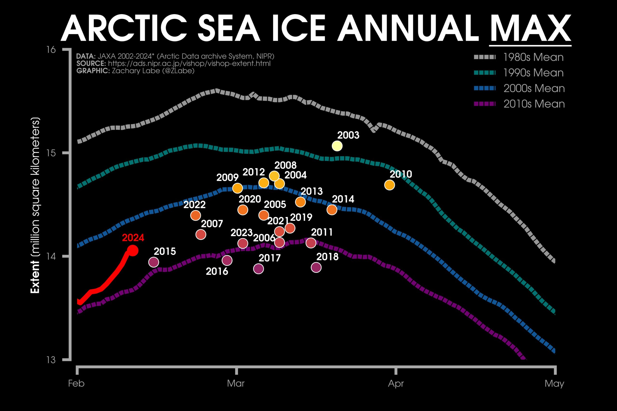
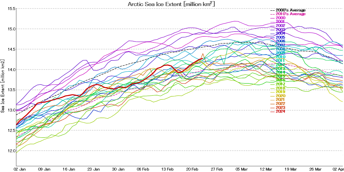
Zack’s graph displays the JAXA/ViSHOP version of Arctic extent, so here too is JAXA’s own graph of the current sea ice extent:
JAXA extent is based on data from the AMSR2 instrument on the GCOM-W satellite, and shows no evidence yet of a local maximum, let alone an annual one for 2024.
A change is perhaps even better than a rest? Let’s start February with a reminder that following close behind another recent Arctic cyclone, Storm Ingunn caused red weather warnings for high winds and avalanches in Norway two days ago:
By yesterday evening another long period, storm driven swell was arriving at the sea ice edge in the Fram Strait, and to a lesser extent in the Barents Sea:
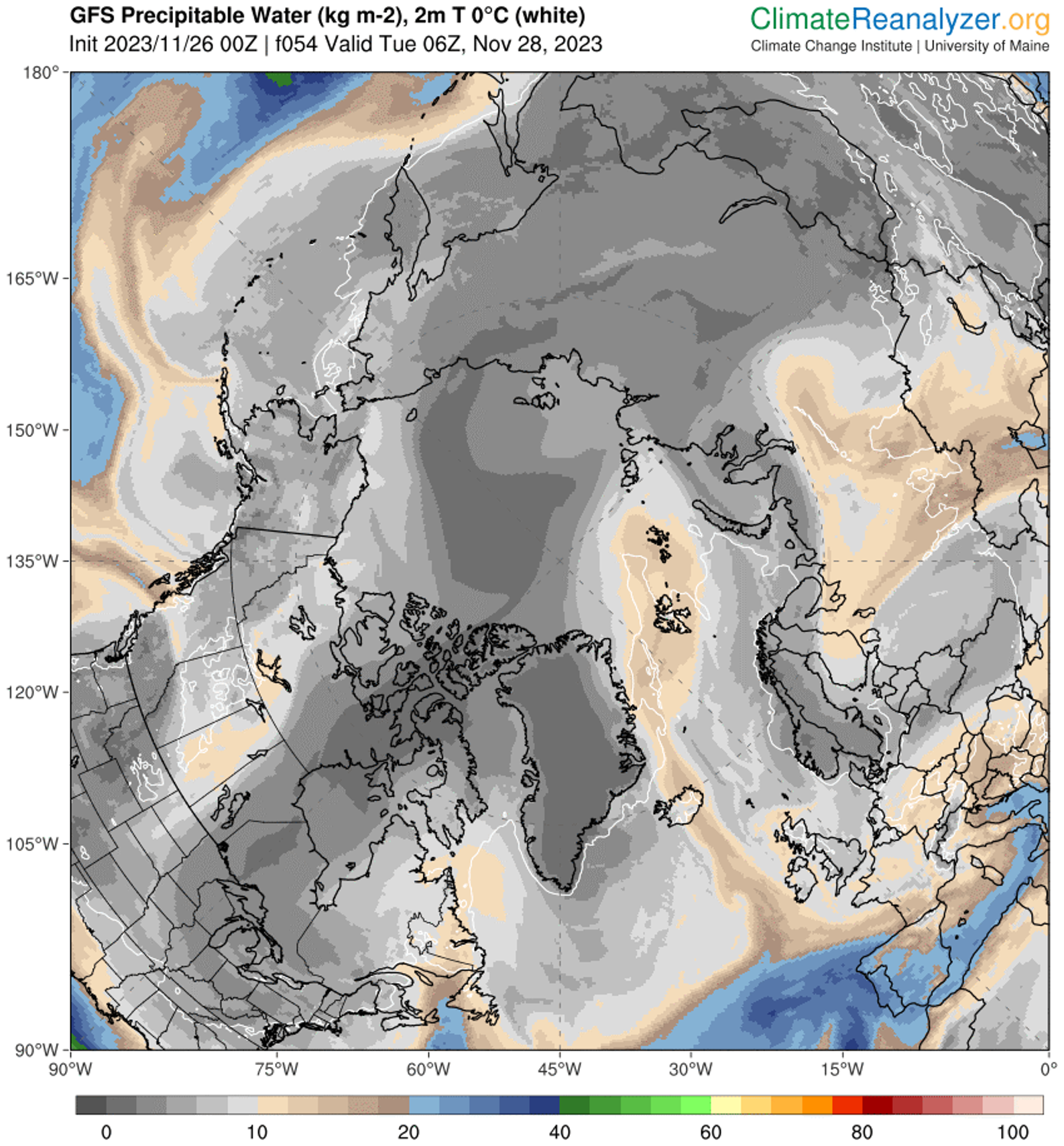
By this morning Ingunn had merged with the remnants of the prior cyclone, as revealed in Climate Reanalyzer’s visualisation of the latest GFS model run::
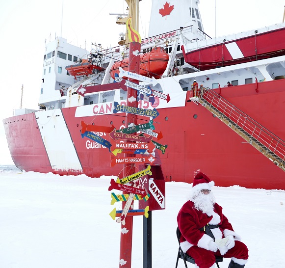
Christmas is rapidly approaching, and Santa and Snow White send festive greetings to one and all from the North Pole:
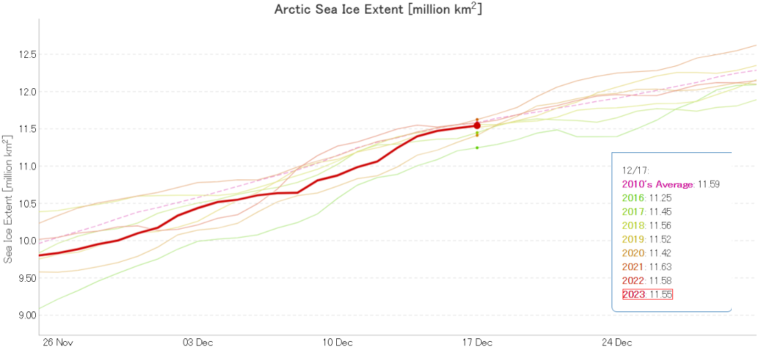
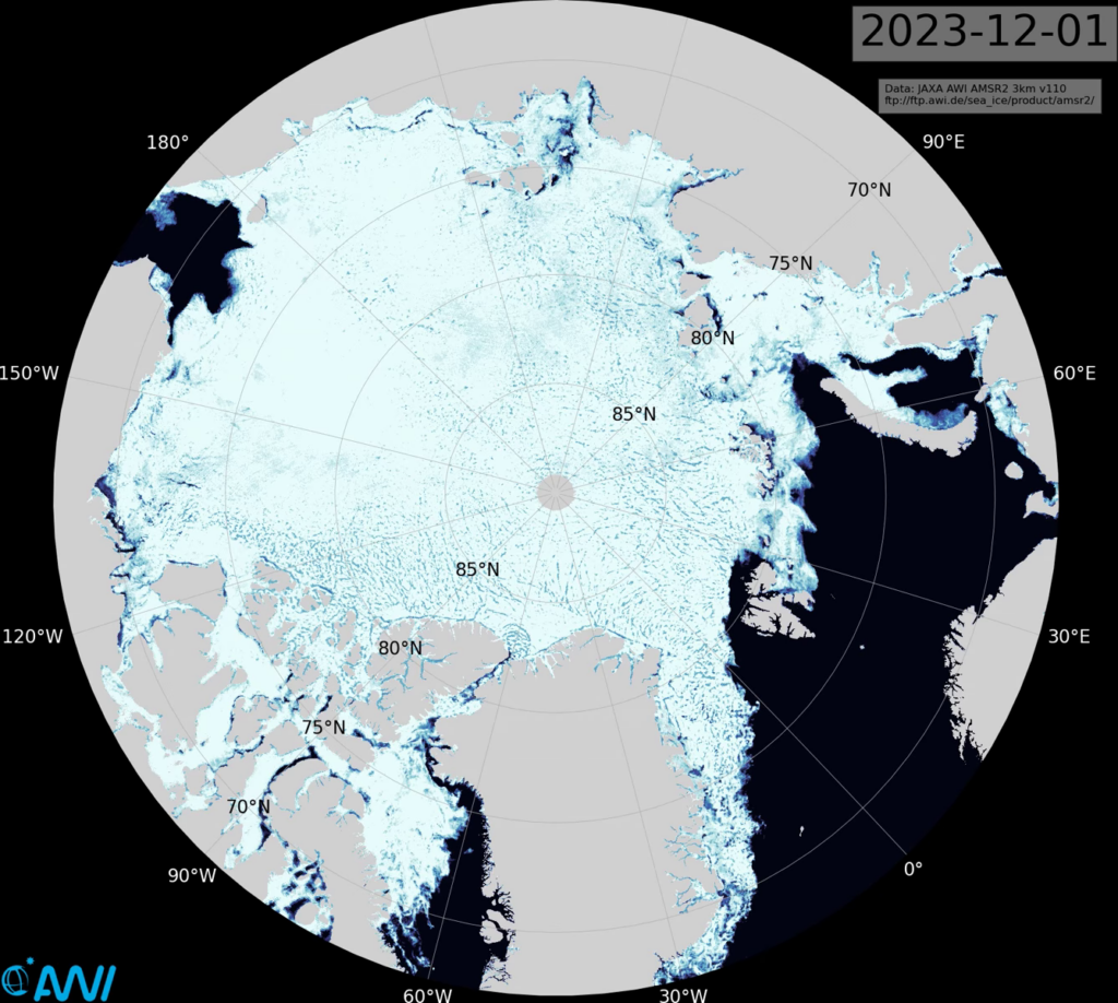
JAXA extent currently seems to be stuck on December 17th, but here’s how it looked a couple of days ago:
Having been comfortably in 3rd lowest position in the satellite era a few days ago, AMSR2 extent is now 5th lowest and very close to the 2010s average for the date.
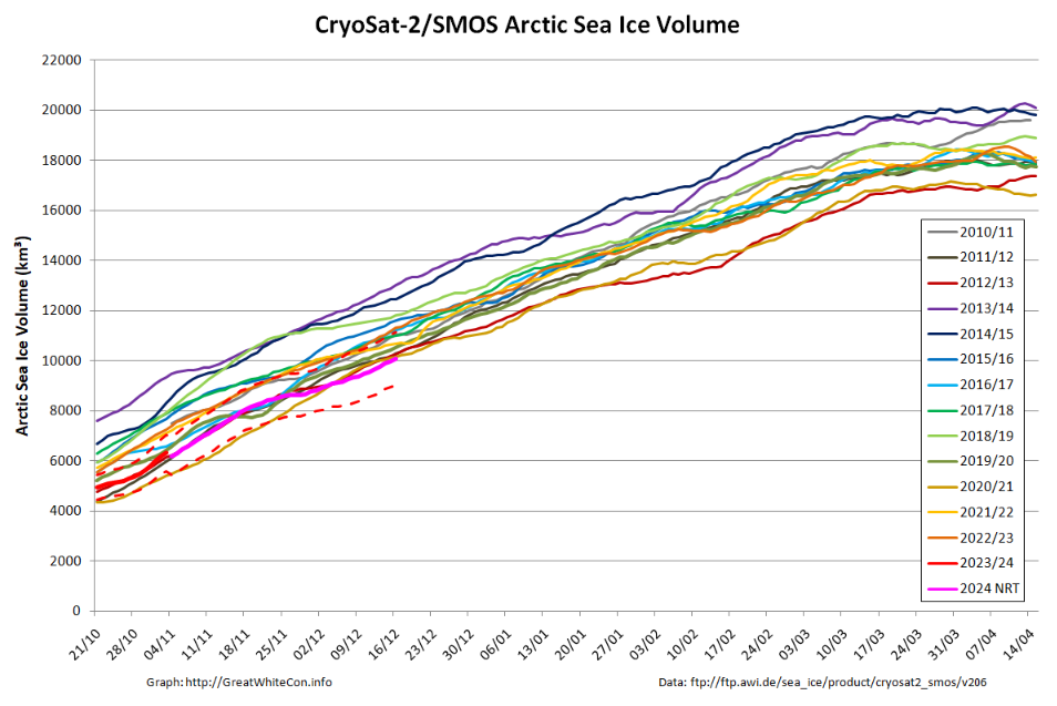
The Alfred Wegener Institute have been releasing reanalysed CryoSat-2/SMOS merged thickness data for a few days, and here is the resulting Arctic sea ice volume chart:
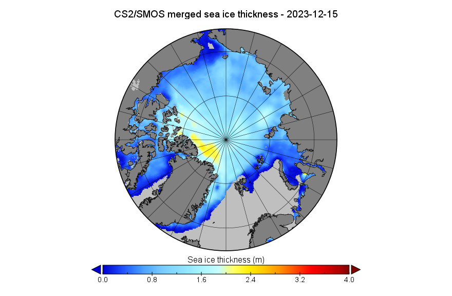
Near real time volume is currently lowest for the date in the CS2 record, but is likely to be revised upwards when the reanalysed data is eventually released. The associated NRT thickness map looks like this for December 15th:
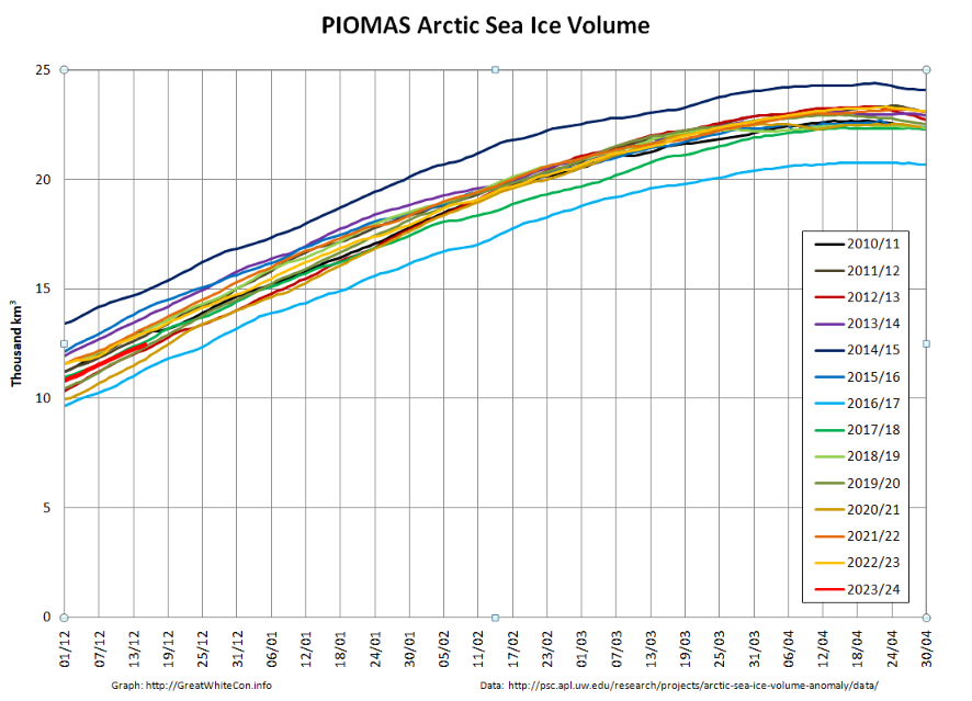
The mid-month PIOMAS modelled gridded thickness data has also been released. The calculated volume is 5th lowest in the satellite era:
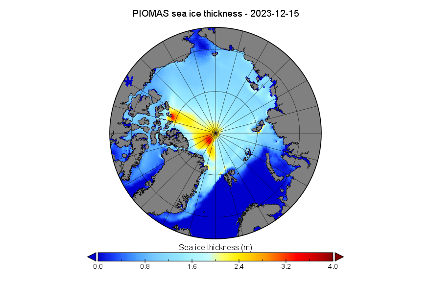
Here too is the PIOMAS thickness map for December 15th:
[Update – December 24th]
Merry Xmas everyone, especially Matt! Here’s a couple of images from the National Snow and Ice Data Center’s latest edition of Arctic Sea Ice News. In the short term sea ice is always melting somewhere:
From November 21 to 28, a series of three extratropical cyclones followed a common track from the northeast coast of Greenland eastward along the northern edge of the Barents, Kara, and Laptev Seas. As each storm moved into the Arctic Ocean, it merged with its predecessors, creating a persistent cyclonic (counter clockwise) wind regime. The first and third of these storms originated in the Icelandic Low region before migrating up the east side of Greenland. The second storm originated just north of Greenland. Simultaneously, a center of high pressure developed over the ice-free part of the Barents Sea, becoming especially strong on November 26 to 28.
This combination of persistent low pressure to the north and west of Svalbard and a high-pressure center to the southeast created a strong, persistent flow from the south of relatively warm and moist air from the North Atlantic Ocean toward Svalbard, which then turned eastward along the marginal ice zone. This is seen as an extension of an atmospheric river into the Arctic. Atmospheric rivers are long narrow corridors that carry a large amount of water vapor. A recent study suggests that atmospheric rivers lead to ice loss by transporting warm, moist air into the Arctic that can limit sea ice growth. This is consistent with the observed pause in seasonal ice growth in late November.
And over the longer term:
[Update – December 26th]
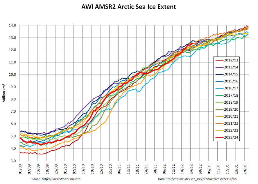
From being near the bottom of the recent pack at the end of November, Arctic sea ice extent is now edging towards the top of the 2010s range. Here’s the AWI high resolution AMSR2 metric:
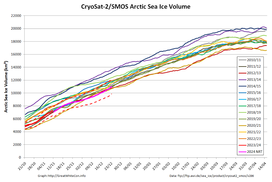
However sea ice volume has not followed suit, and remains near the bottom of the range:
Here’s an animation of sea ice motion over the last month, revealing amongst other things the recent rapid refreeze of the Chukchi Sea (click to animate):
[Update – December 29th]
Matt is getting very excited about the allegedly “high Arctic sea ice extent” over on XTwitter. So is Tony Heller, although he has also helpfully provided convincing empirical evidence that the IPCC’s global warming “predictions” are correct!
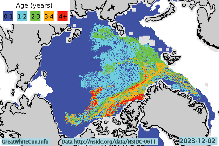
However neither of them seem to be at all interested in the age of Arctic sea ice. Here’s the early December update:
Drifting off topic only slightly, whilst perusing social media I also found this animation from Kev Pluck highly amusing:
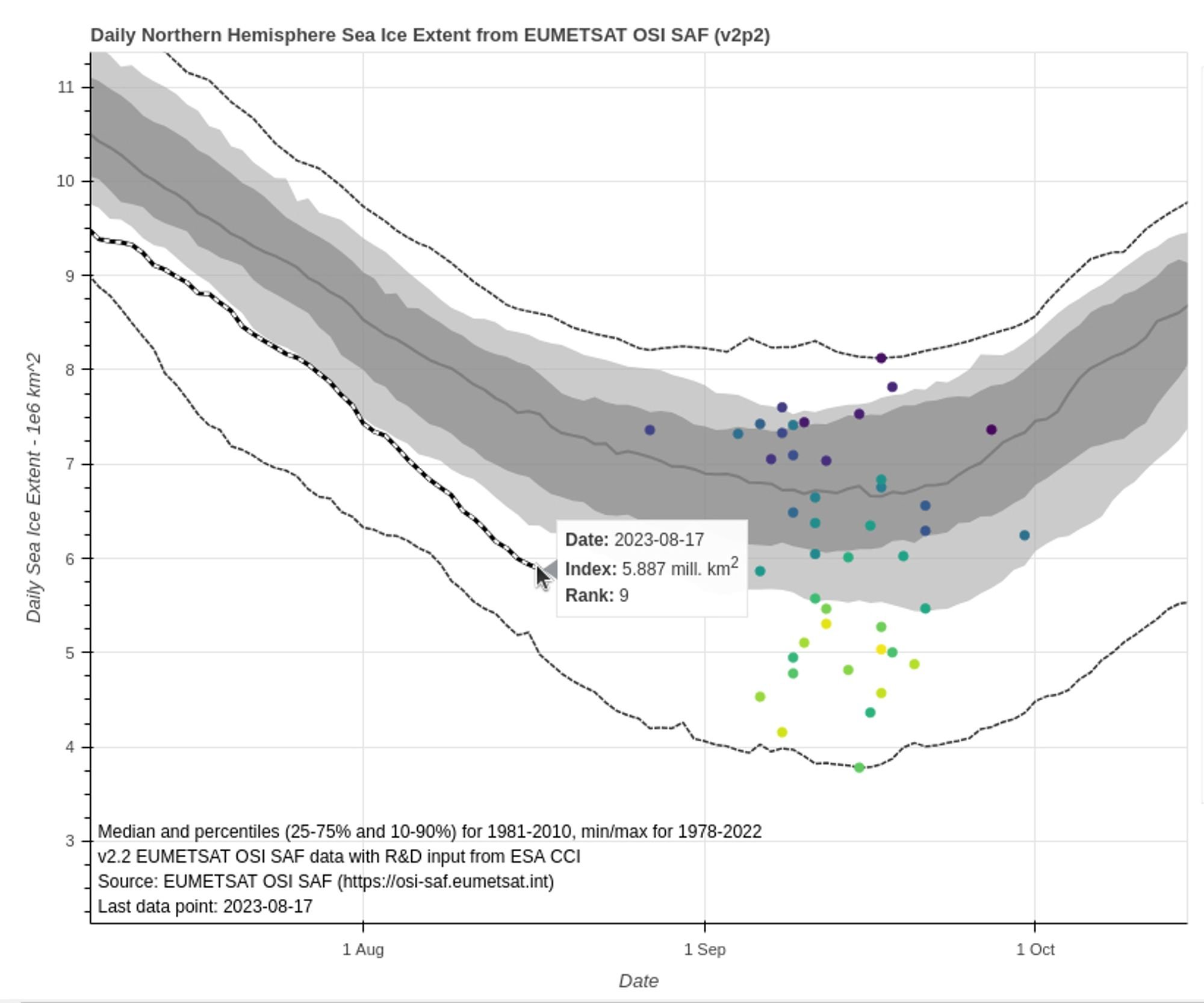
It’s that time of year again! Tony Heller has been asserting that “summer is over at the North Pole” for several weeks now, and the 2023 Arctic sea ice minimum extent will occur at some point over the next four or five weeks. The exact date and level will almost certainly vary from one extent metric to the next.
To get the minimum extent ball rolling, here’s Signe Aaboe’s graph of previous summer minima based on OSI SAF data:
Here too is Zack Labe’s equivalent, based on JAXA data:
We have grandchildren visiting this week, so it seems prudent to get the new open thread started a day early, and before they wake up!
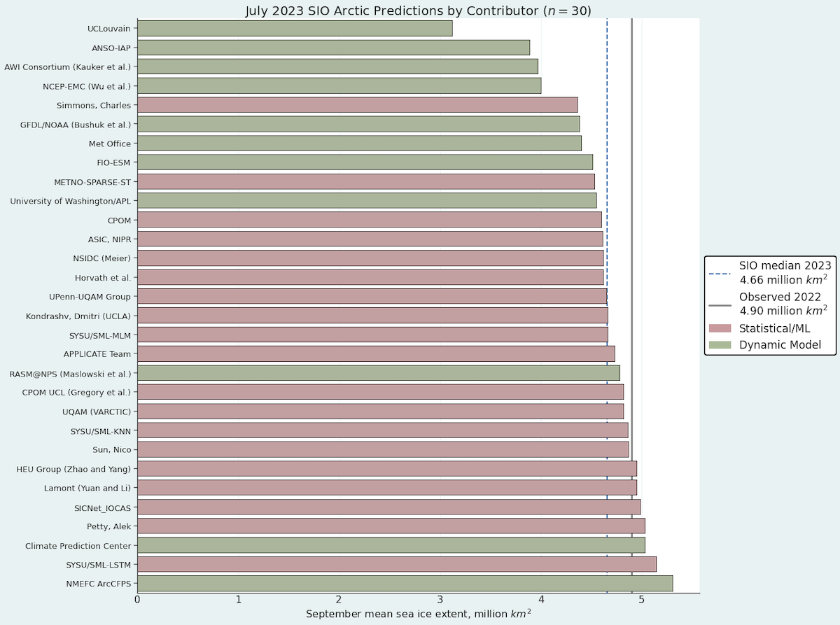
The ARCUS Sea Ice Prediction Network July report has recently been published. Here’s the graphic overview of the 30 predictions for September sea ice monthly average extent:
The July median forecasted value for pan-Arctic September sea-ice extent is 4.66 million square kilometers with interquartile values of 4.51 and 4.87 million square kilometers, while individual forecasts range from 3.12 and 5.30 million square kilometers. We note the lowest forecast is an outlier, and the only forecast that predicts a new record September sea-ice extent value (current record is September 2012, with a sea-ice extent of 3.57 million square kilometers).
My Arctic alter ego was checking out the new “X” rated edition of Twitter when “she” couldn’t help but notice that Elon Musk had allowed Tony Heller back into the climate “debate” thereon, albeit with a new handle.
“Snow White” also noticed that for some strange reason Tony was telling lots of porky pies about Arctic sea ice again! Hence:
Here's @TonyClimate demonstrating yet again that either:
1) He has no understanding of all things #Arctic, or
2) He understands well enough, but he pulls the wool over the eyes of his faithful flock of followers.https://t.co/yYNhpSncLE
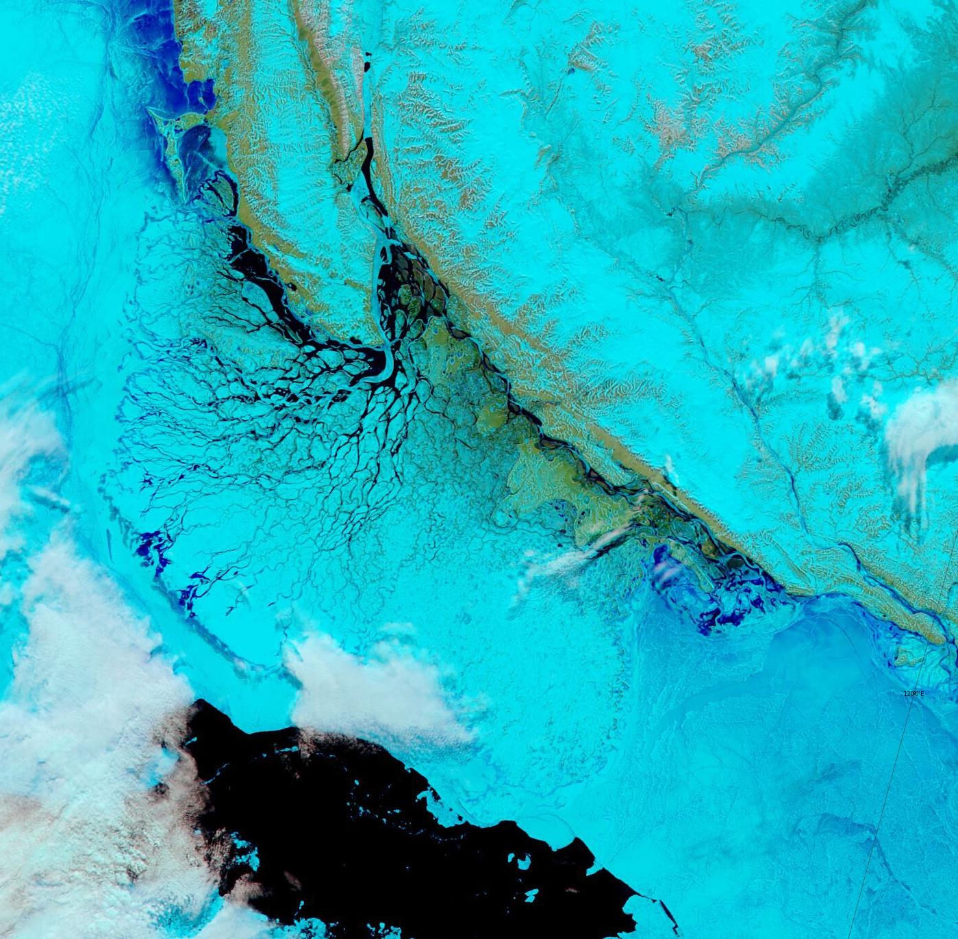
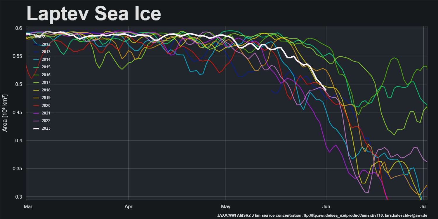
By way of a change, which is allegedly as good as a rest, let’s start the new month with a very pretty and almost cloud free “pseudo-colour” image of the Lena Delta and adjacent areas of the Laptev Sea:
“False colour” image of the Lena Delta on June 1st from the MODIS instrument on the Aqua satellite
I should of course add “in the satellite era”, but the title is pretty unwieldy as it is!
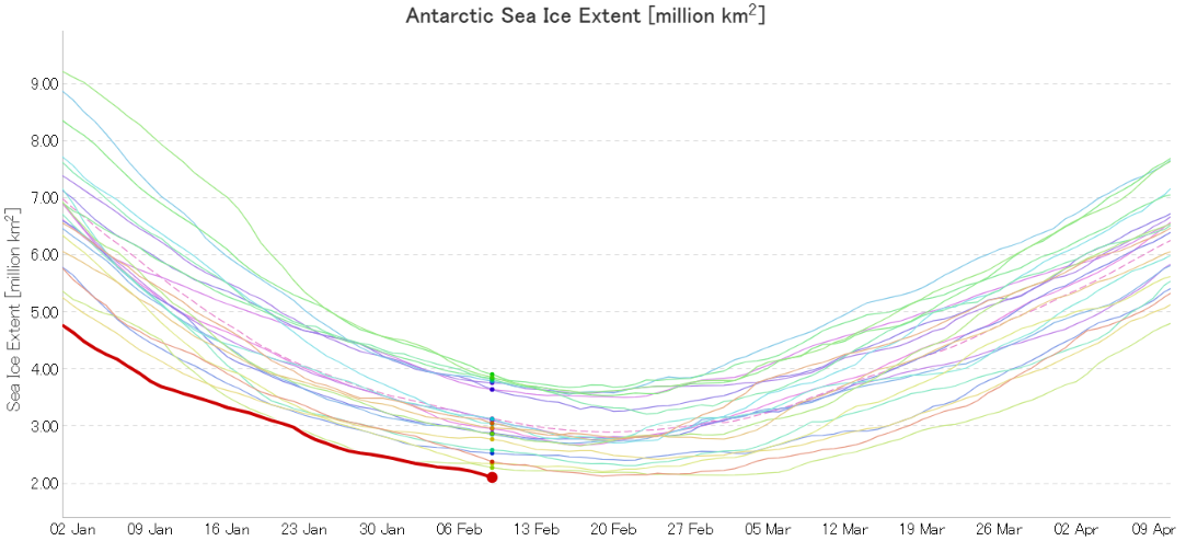
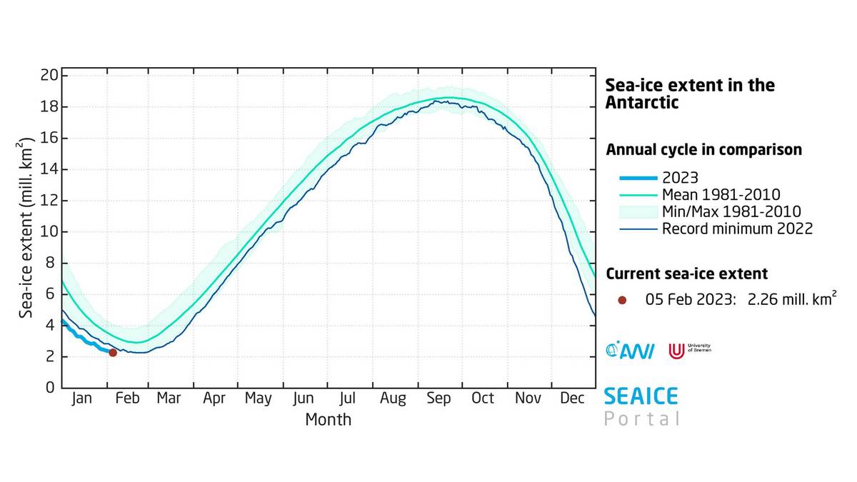
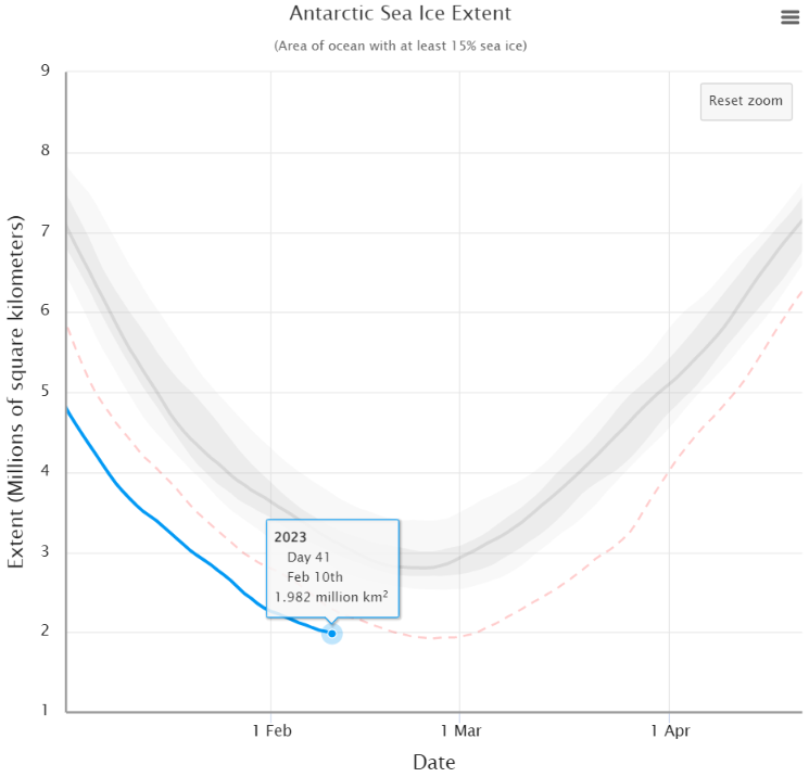
I was up early (UTC) to check the latest JAXA data, and sure enough that confirmed a new record minimum Antarctic sea ice extent of 2.11 million km² was reached yesterday:
Having added a note to that effect the Arctic open thread, Lars Kaleschke from the Alfred Wegener Institute pointed out over on Mastodon that the AWI had published a press release about the event this morning:
Let’s take a closer look at what the AWI had to say:
On 8 February 2023, at 2.20 million square kilometres, the Antarctic sea ice extent had already dropped below the previous record minimum from 2022 (2.27 million square kilometres on 24 February 2022). Since the sea ice melting in the Antarctic will most likely continue in the second half of the month, we can’t say yet when the record low will be reached or how much more sea ice will melt between now and then,” says Prof Christian Haas, Head of the Sea Ice Physics Section at the Alfred Wegener Institute, Helmholtz Centre for Polar and Marine Research (AWI), with regard to the current developments in the Antarctic. “The rapid decline in sea ice over the past six years is quite remarkable, since the ice cover hardly changed at all in the thirty-five years before. It is still unclear whether what we are seeing is the beginning of a rapid end to summer sea ice in the Antarctic, or if it is merely the beginning of a new phase characterised by low but still stable sea ice cover in the summer.”
Here’s how that news looks in the AWI’s official press release:
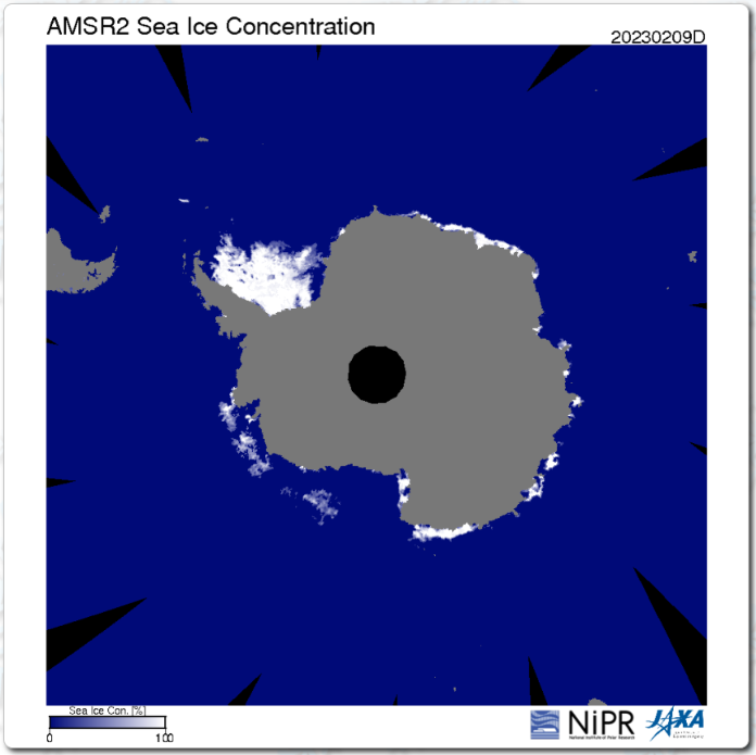
By way of prognostication here too is the current JAXA AMSR2 concentration map:
There are some low concentration areas which suggest further extent reductions still to come, despite the recent uptick in the high resolution graph.
Getting back to the AWI’s text:
The melting has progressed since December 2022, especially in the Bellingshausen and Amundsen Seas in the West Antarctic; the former is virtually ice-free. That is also where the research vessel Polarstern currently is, exploring the evidence left behind of past glacials and interglacials. According to expedition leader and AWI geophysicist Prof Karsten Gohl, who is now in the region for the seventh time, having first come in 1994: “I have never seen such an extreme, ice-free situation here before. The continental shelf, an area the size of Germany, is now completely ice-free. Though these conditions are advantageous for our vessel-based fieldwork, it is still troubling to consider how quickly this change has taken place.”
Polarstern in ice free Bellingshausen Sea, West Antarctica, in January 2023. (Photo: Daniela Röhnert)
Analyses of the current sea ice extent, conducted by the Sea Ice Portal team, show that, for the entire month of January 2023, the ice was at its lowest-ever extent recorded for the time of year since the beginning of record-keeping in 1979. The monthly mean value was 3.22 million square kilometres, ca. 478,000 square kilometres (an area roughly the size of Sweden) below the previous minimum from 2017. With regard to its long-term development, the Antarctic sea ice shows a declining trend of 2.6 percent per decade. This is the eighth consecutive year in which the mean sea-ice extent in January has been below the long-term trend.
But what has caused the current lack of Antipodean sea ice? The press release continues:
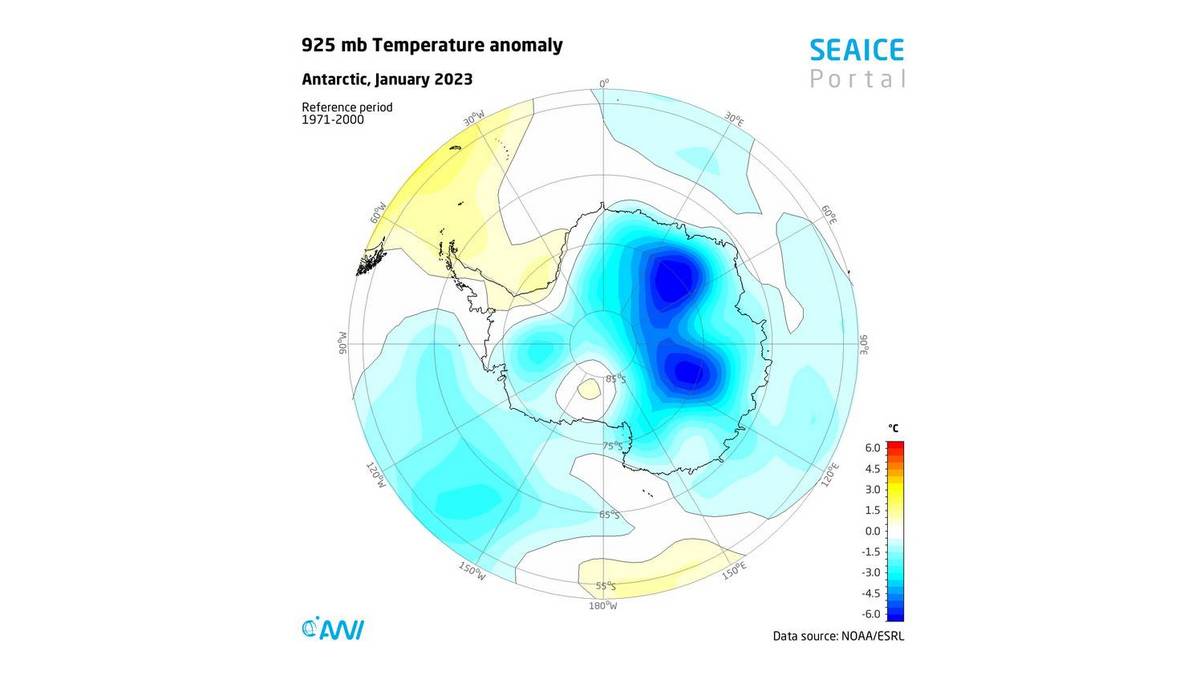
This intense melting could be due to unusually high air temperatures to the west and east of the Antarctic Peninsula, which were ca. 1.5 °C above the long-term average. In addition, the Southern Annular Mode (SAM) is in a strongly positive phase, which influences the prevailing wind circulation in the Antarctic. In a positive SAM phase (like today), a low-pressure anomaly forms over the Antarctic, while a high-pressure anomaly develops over the middle latitudes. This intensifies the westerly winds and causes them to contract toward the Antarctic. As a result, upwelling of circumpolar deep water on the continental shelf intensifies in the Antarctic, promoting sea-ice retreat. More importantly, it also intensifies the melting of ice shelves, an essential aspect for future global sea-level rise.
Air temperature anomalies in °C at 925 hPa pressure level in Antarctica in January 2023 compared to the long-term mean 1971-2000. (Graphic: meereisportal.de)
The press release concludes:
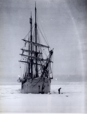
Historical records also reflect the tremendous changes. For example, in the Antarctic summer 125 years ago, the Belgian research vessel Belgica was trapped in the massive pack ice for more than a year – in exactly the same region where the Polarstern can now operate in completely ice-free waters. The photographs and diaries of the Belgica’s crew offer a unique chronicle of the ice conditions in the Bellingshausen Sea at the dawn of the industrial age, which climate researchers often use as a benchmark for comparison with today’s climate change.
Belgica became ice bound near Peter I island on February 28th 1898. On board was second officer Roald Amundsen. The leader of the expedition, Adrien de Gerlache, published a French language book about the voyage in 1902: “Quinze mois en Antarctique“.
Belgica ice bound in the Bellingshausen Sea
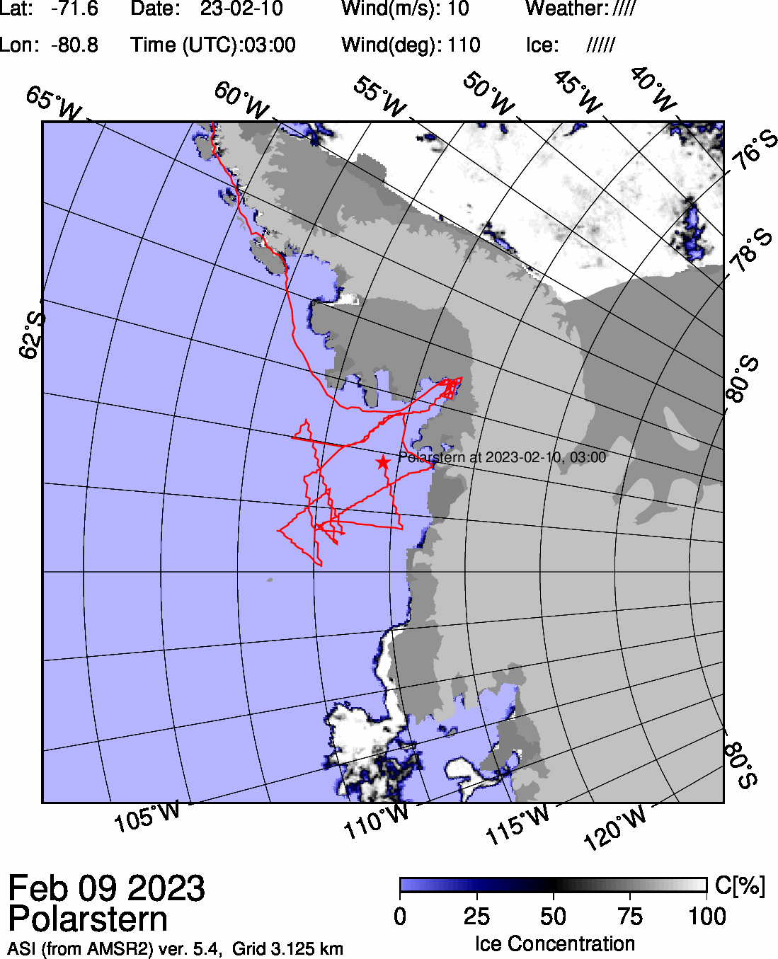
Finally, for the moment at least, here is the University of Bremen’s map of Polarstern’s current location and the sea ice concentration in the vicinity thereof:
[Edit – February 11th]
JAXA Antarctic sea ice extent is now down to 2.06 million km². Accompanied by a significant fall in Arctic extent, JAXA’s flavour of global sea ice extent has now also reached the lowest level ever recorded in the satellite era, at 15.51 million km² :
P.S. The NSIDC’s 5 day averaged extent hasn’t quite reached a record minimum yet:
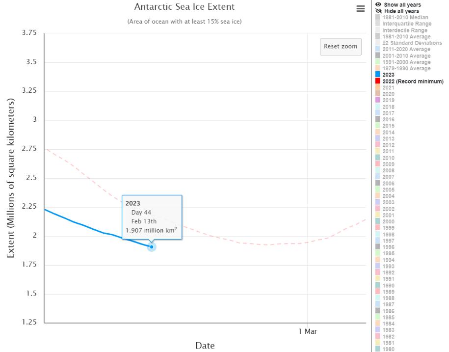
However their daily extent has reached a new satellite era record minimum:
The reality is that @NSIDC daily #Antarctic#SeaIce extent for February 10th is 1.90 million km².
The NSIDC’s 5 day average Antarctic sea ice extent metric has duly reached a new record low level of 1.91 million km² :
P.S. The NSIDC has now published itsown article about the record minimum:
With a couple more weeks likely left in the melt season, the extent is expected to drop further before reaching its annual minimum. Much of the Antarctic coast is ice free, exposing the ice shelves that fringe the ice sheet to wave action and warmer conditions…
Extent has tracked well below last year’s melt season levels since mid-December. As noted in our previous post, a positive Southern Annular Mode has led to stronger-than-average westerly winds. Along with a strong Amundsen Sea Low, the weather conditions have brought warm air to the region on both sides of the Antarctic Peninsula. This has largely cleared out the ice cover in the Amundsen and Bellingshausen Seas, and reduced the sea ice extent in the northwestern Weddell Sea. Sea ice is patchy and nearly absent over a long stretch of the Pacific-facing coastline of Antarctica. Earlier studies have linked low sea ice cover with wave-induced stresses on the floating ice shelves that hem the continent, leading to break up of weaker areas.
Antarctic sea ice extent has been highly variable over the last several years. While 2022 and 2023 have had record low minimum extent, four out of the five highest minimums have occurred since 2008. Overall, the trend in Antarctic minimum extent over 1979 to 2023 is near zero. The current downward linear trend in the Antarctic minimum extent from 1979 to 2023 is 2,400 square kilometers per year, or 0.9 percent per decade, which is currently not statistically significant. Nevertheless, the sharp decline in sea ice extent since 2016 has fueled research on potential causes and whether sea ice loss in the Southern Hemisphere is developing a significant downward trend.
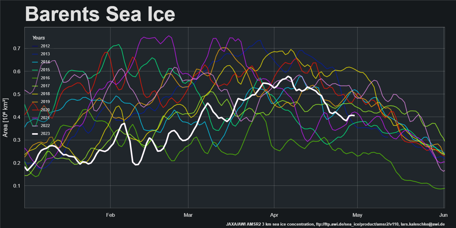
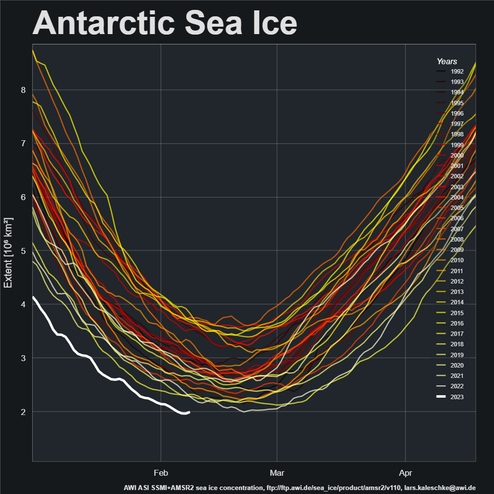
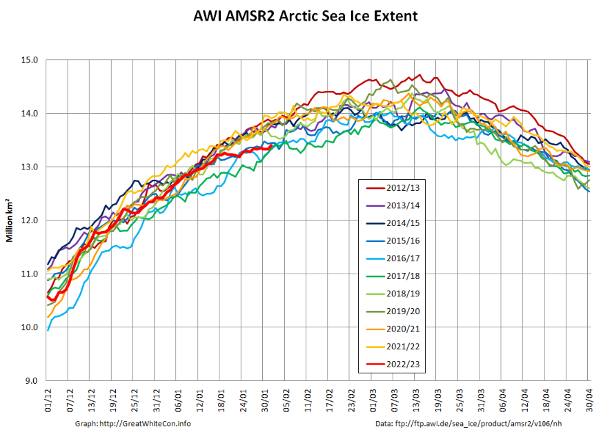
A new month has arrived, and during January several Arctic sea ice metrics have been drifting towards the bottom of their respective decadal ranges. To begin with here is AWI’s high resolution AMSR2 extent graph, which is currently very close to being lowest for the date in the AMSR2 record:
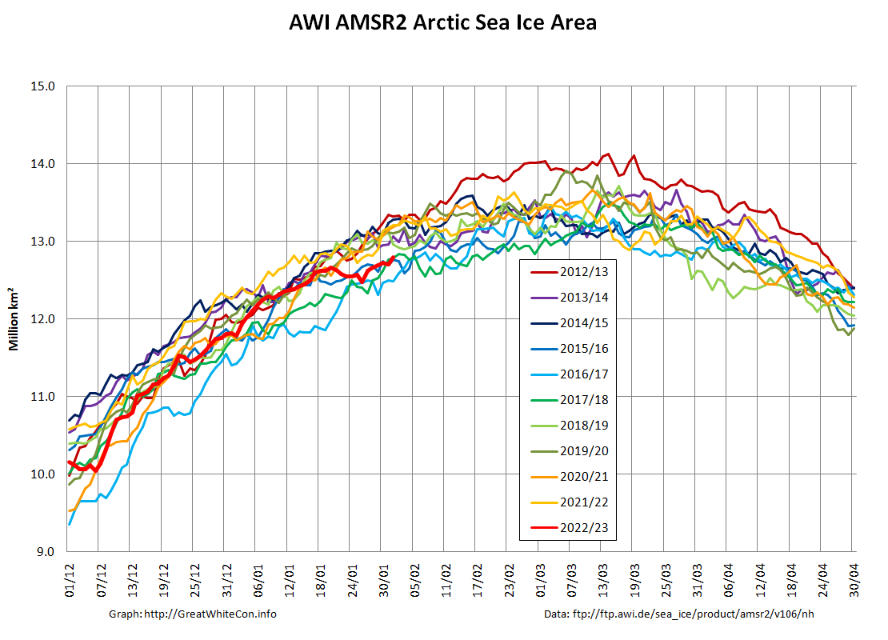
However that is less the case for area:
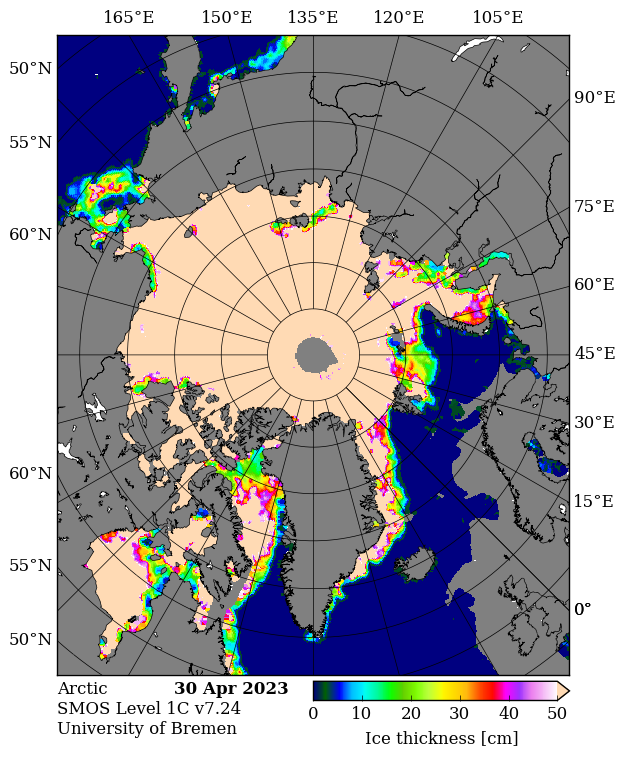
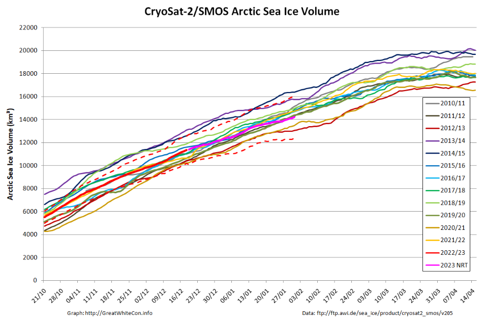
Taylor is keen to see the PIOMAS volume data for January, but whilst we wait for the latest Polar Science Center update here is the CryoSat-2/SMOS volume graph, which now includes a couple of month’s worth of reanalysed results as well as more recent near real time numbers:
Here too is the start of month CS2/SMOS thickness map:
This website uses cookies to improve your experience. We'll assume you're ok with this, but you can opt-out if you wish. Cookie settingsACCEPT
Privacy & Cookies Policy
Privacy Overview
This website uses cookies to improve your experience while you navigate through the website. Out of these, the cookies that are categorized as necessary are stored on your browser as they are essential for the working of basic functionalities of the website. We also use third-party cookies that help us analyze and understand how you use this website. These cookies will be stored in your browser only with your consent. You also have the option to opt-out of these cookies. But opting out of some of these cookies may affect your browsing experience.
Necessary cookies are absolutely essential for the website to function properly. This category only includes cookies that ensures basic functionalities and security features of the website. These cookies do not store any personal information.
Any cookies that may not be particularly necessary for the website to function and is used specifically to collect user personal data via analytics, ads, other embedded contents are termed as non-necessary cookies. It is mandatory to procure user consent prior to running these cookies on your website.