After a quiet couple of years due to the Covid-19 pandemic there are numerous cruises through the Northwest Passage planned for the summer of 2022. Some (very!) small vessels are also currently scheduled to attempt that perilous journey. First of all let’s take a look at a map of the assorted routes through the Canadian Arctic Archipelago:

plus another map which includes a few more place names:

Next comes news of the expeditions planned by a variety of intrepid adventurers. According to Karl Kruger’s web site :
In 2022, Karl will attempt to become the first human to paddle 1,900 miles of the Northwest Passage on a standup paddleboard.
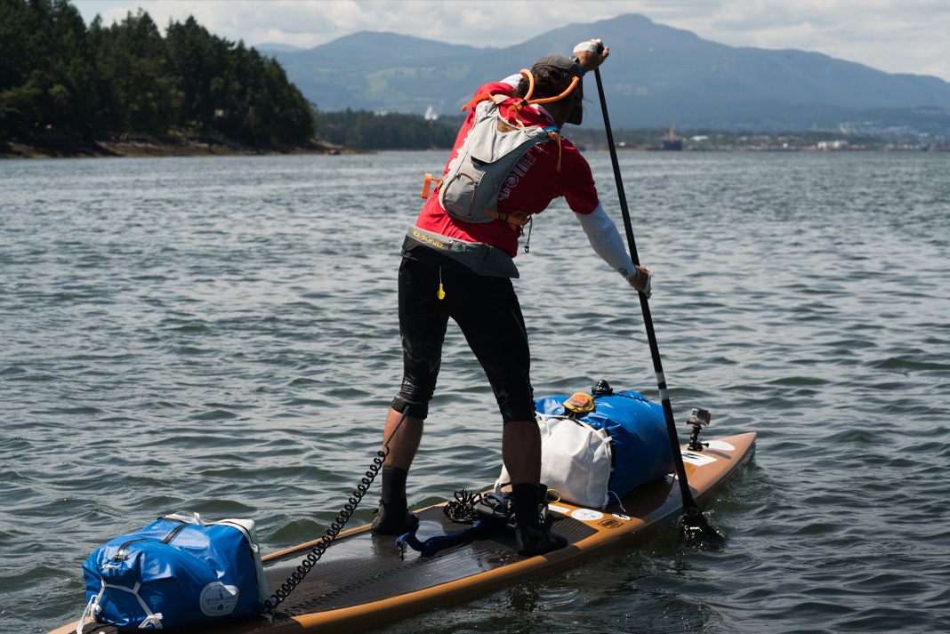
The article at the link is undated, but suggests that Karl initially intended to set off for Pond Inlet from Tuktoyaktuk in July 2019, but postponed the trip until the summer of 2020. By then Covid restrictions were in place, so next month provides the first opportunity for him to attempt the journey once again.
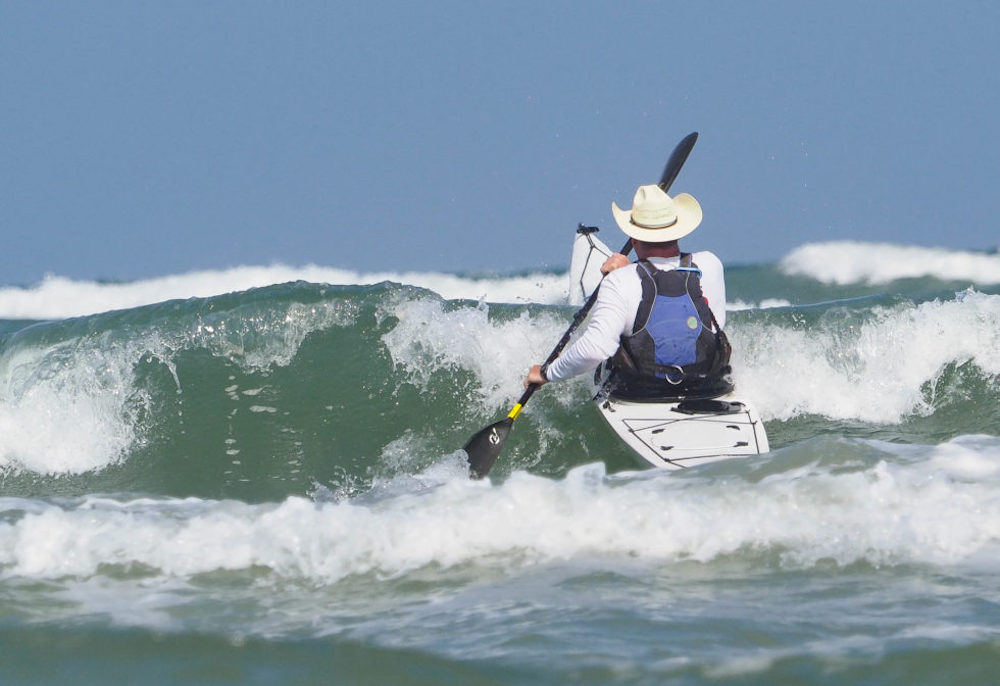
Another previously postponed trip is planned for this summer by the Arctic Cowboys, paddling in kayaks:
Until Roald Amundsen made the first successful sea crossing of the Northwest Passage (1903 – 06), this labyrinth of ice took hundreds of lives as explorers attempted to break through the icy barriers, hull crushing rocks and violent arctic storms to make the journey across the top of the world.
Since then, many sailboats and ships have successfully plied the Passage, though modern sailors still fall prey to the desolate elements. A handful of kayakers have attempted the journey and completed parts of the route in multi-year attempts, going over land and over ice, but no kayaker has made the journey in one single season and without portaging over land.
This is the goal for the Arctic Cowboys.
1900 miles in 60 days, across the top of North America.
Also relying on muscle power will be the Northwest Passage Expedition. According to the expedition web site:
In 2022 an international team of adventurers and ocean rowers will attempt to row the Northwest Passage, the arctic route between the Atlantic and Pacific Oceans considered the Last Great First. This expedition is only possible because the regions climate is changing, and the sea ice is retreating each year gradually opening the route from July to September.
The expedition will follow the 3,700km arctic route from Baffin Island, Canada, to Point Barrow, Alaska and will draw attention to the changing environment, collecting meaningful data for climate scientists at New York University and Big Blue Ocean Cleanup.

However earlier this month it was announced on the expedition’s blog that:
We are postponing the expedition until next summer (2023). We have had reports that the ice is not favourable this year and also we have had several supply line issues and are still waiting on kit ordered before Christmas in some instances.
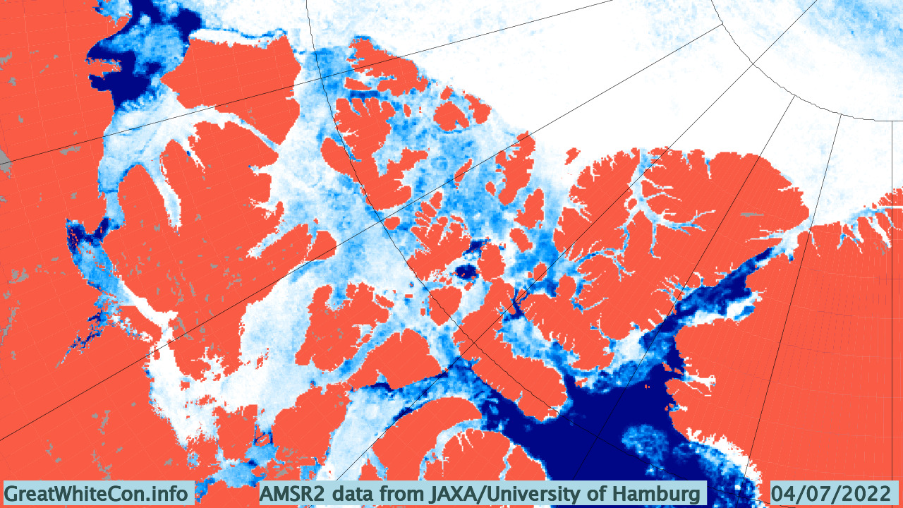
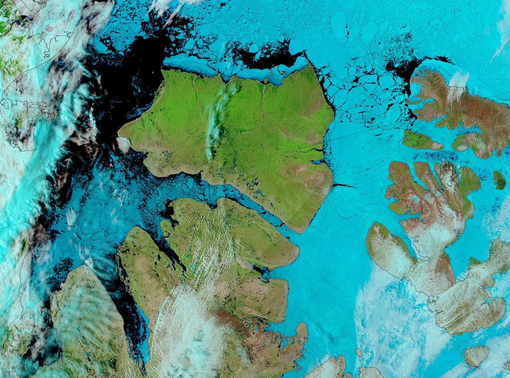
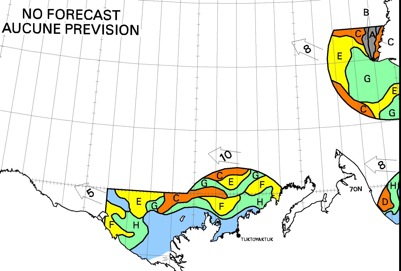
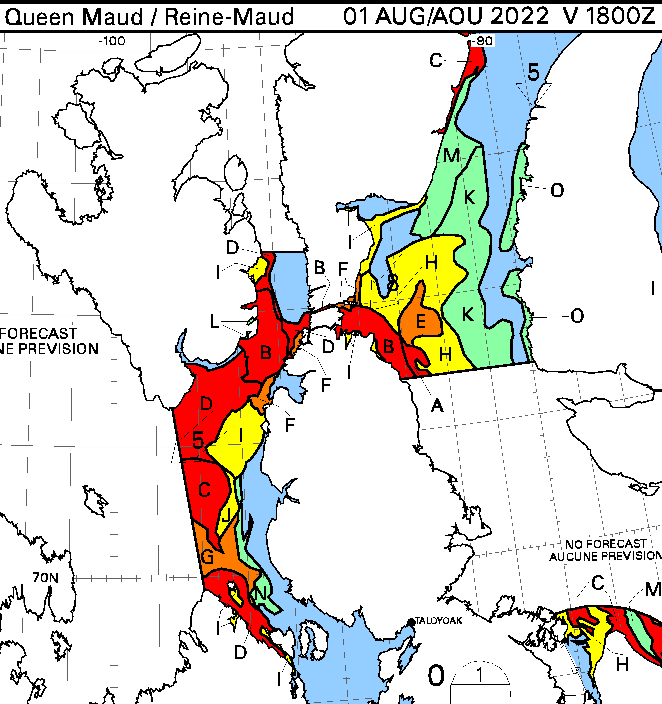
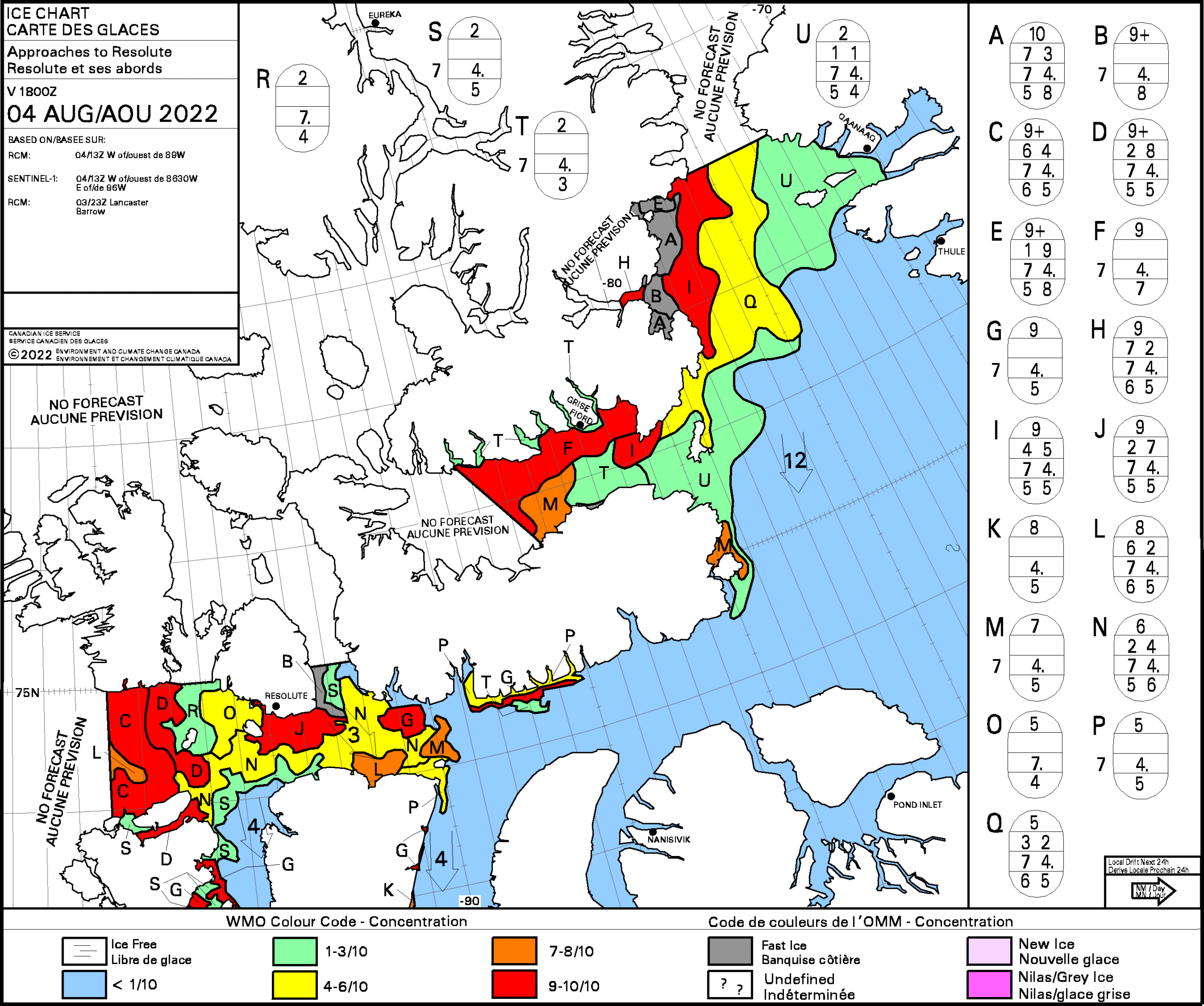
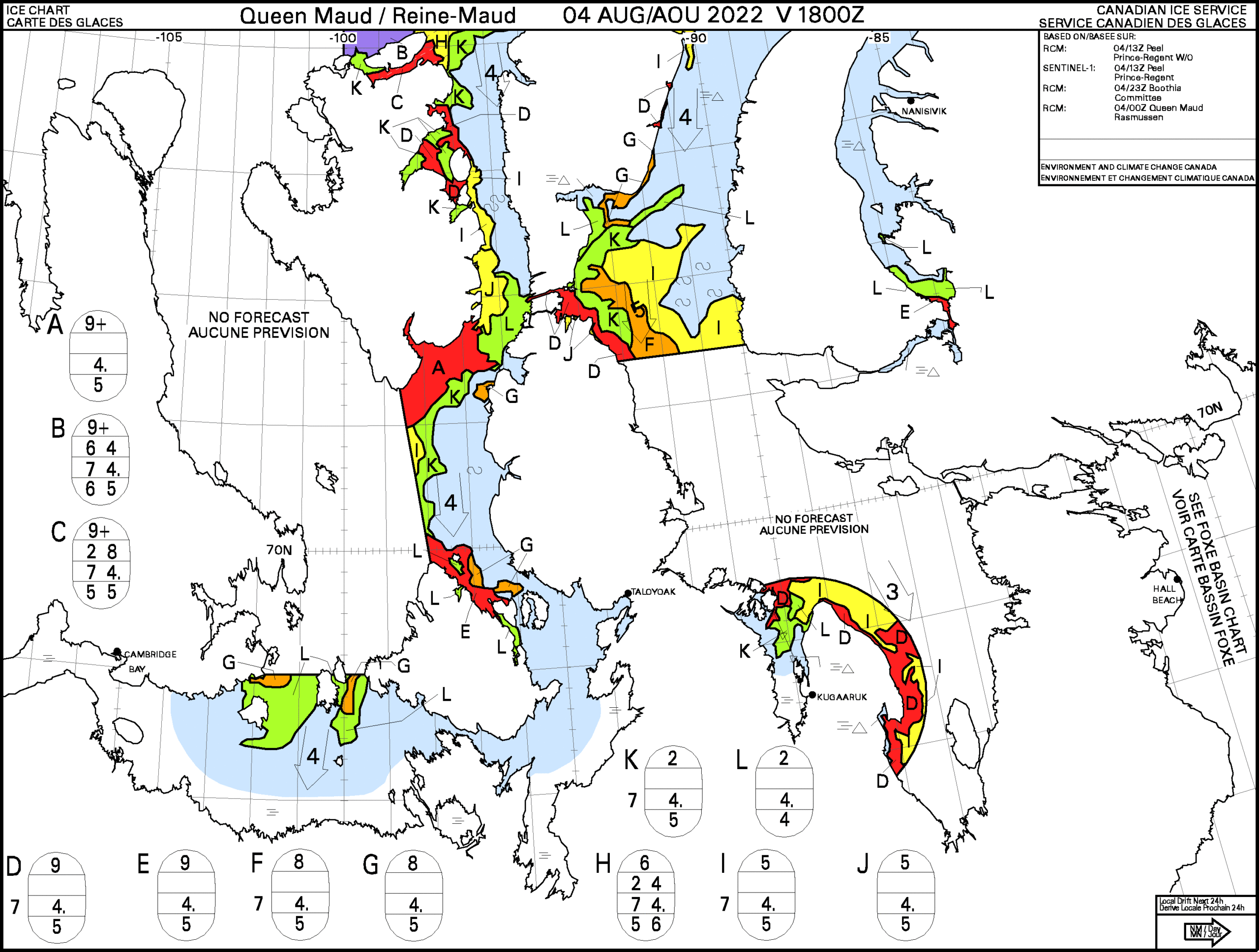
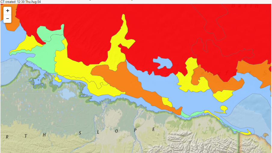
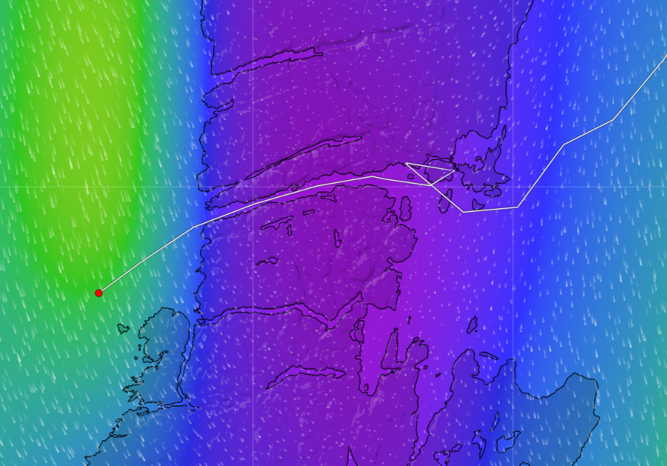
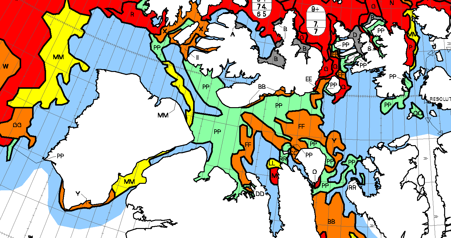
I don’t know where those reports of unfavourable ice conditions came from, but to start our coverage of the Northwest Passage in 2022 here are the most recent Canadian Ice Service sea ice type maps:
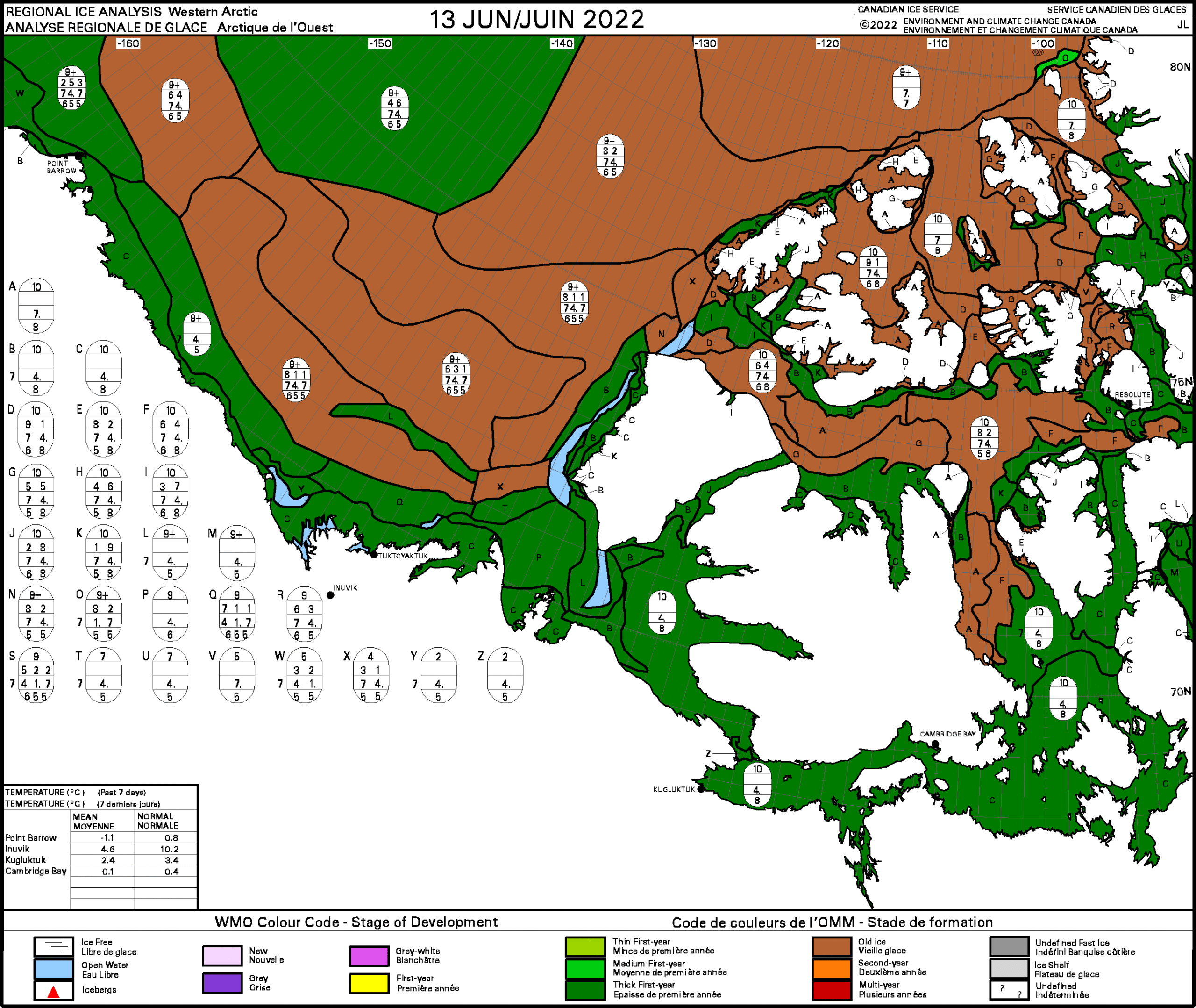
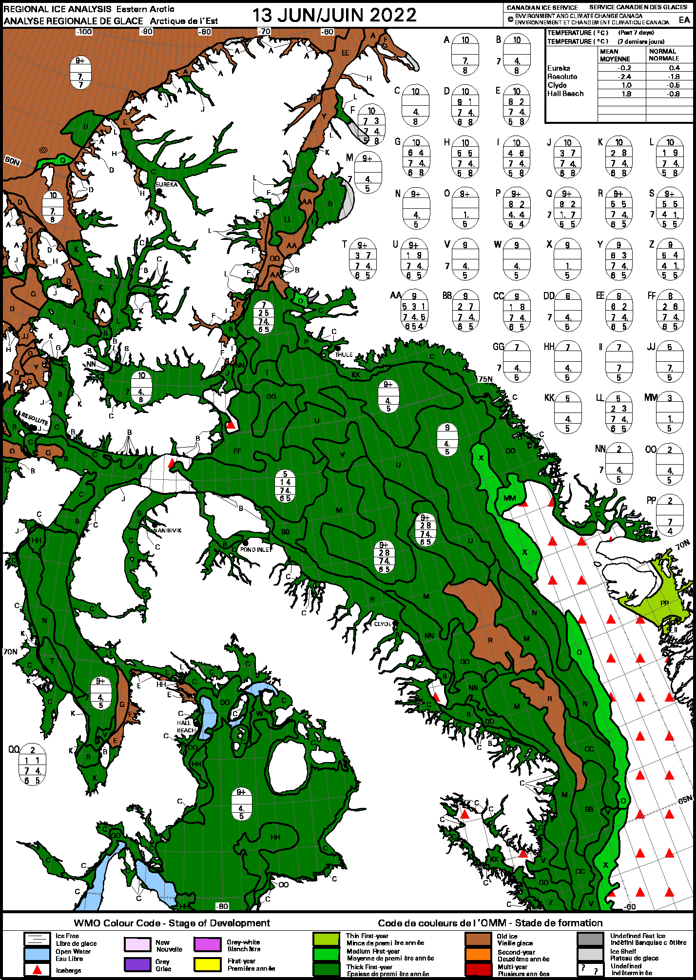
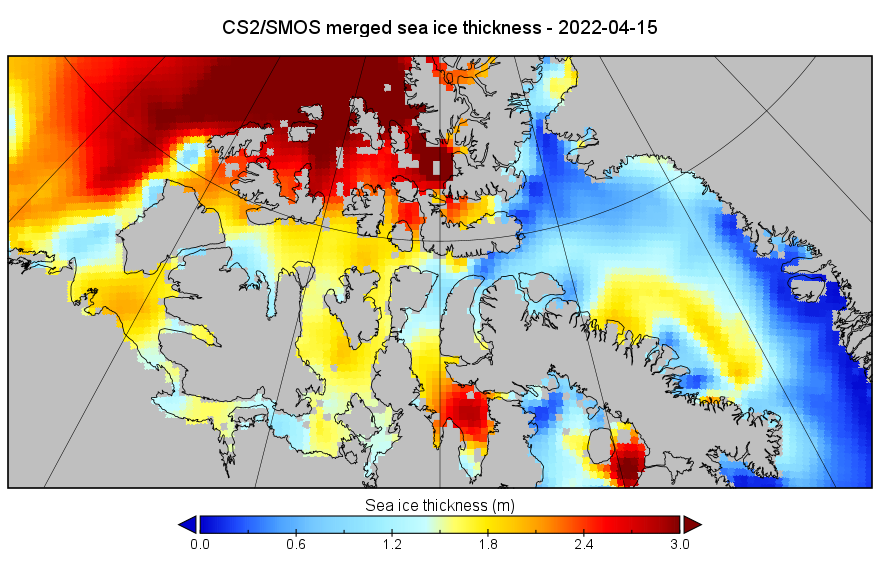
There is currently no “old ice” near routes 5 and 6 via Bellot Strait. For more insight into the thickness of the “thick first year ice” en route here is the Alfred Wegener Institute’s CryoSat-2/SMOS merged thickness map from mid April:
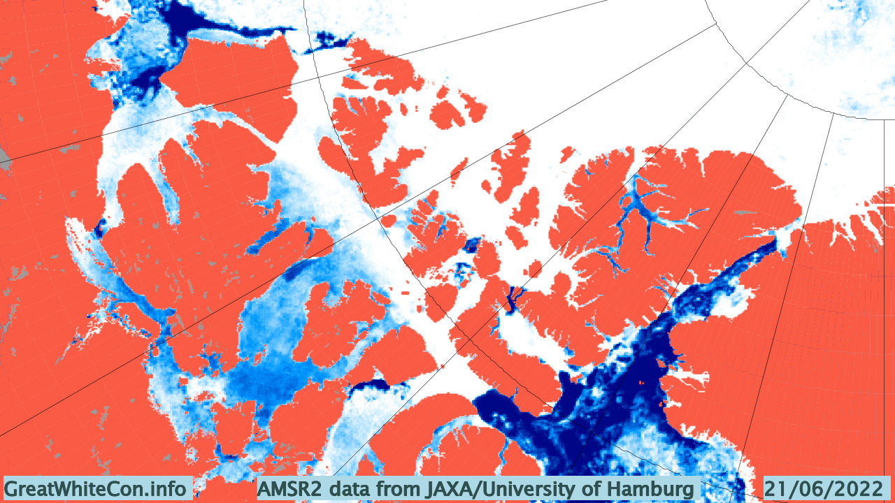
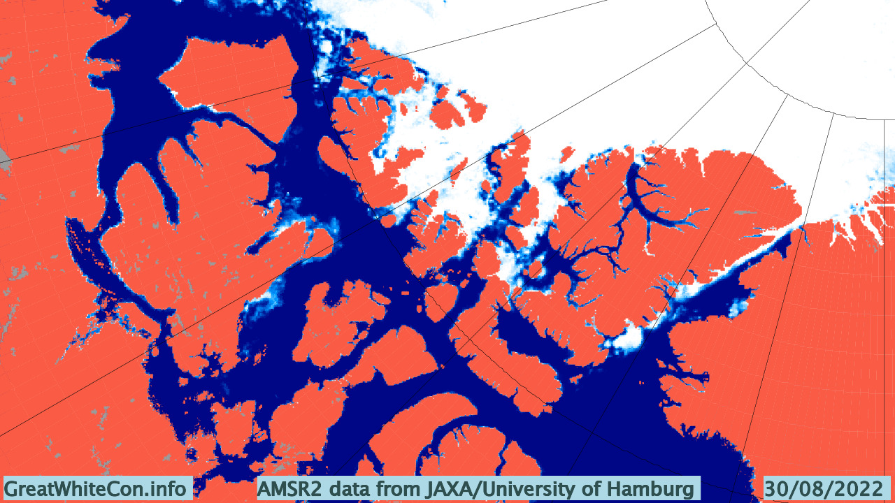
Here too is the latest AMSR2 concentration map of the CAA:
All in all I currently see no reason why the passage won’t be open for “small vessels” later this summer. Whether it will be open for long enough to row or paddle through it is another matter entirely!
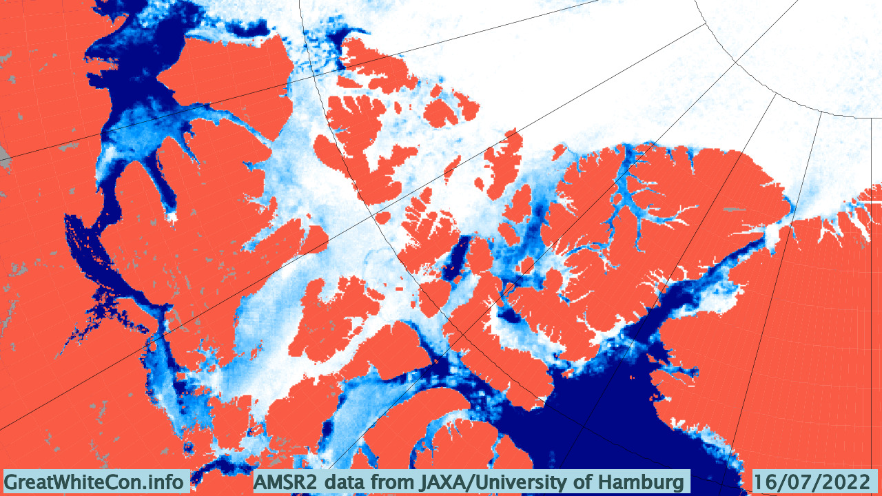
[Edit – June 25th]Surface melt has now spread across almost the entire Northwest Passage:
The sea ice is disintegrating across Lancaster Sound and Prince Regent Inlet:
Amundsen’s route (number 6 on the map at the top) via Rae and Simpson Straits is also beginning to break up. Albeit not part of the passage itself, the same applies to the sea ice in the Queens Channel north of Cornwallis Island.
Here too is the current AMSR2 sea ice concentration map of the Northwest Passage:
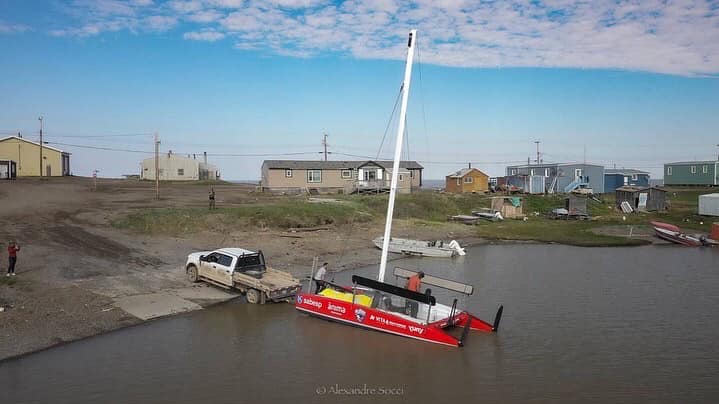
Several more traditional “small craft” are also attempting a voyage through the Northwest Passage this summer. First in the queue is Alberto “Beto” Pandiani in his catamaran “Igloo”. Beto has cut off a large section of the route by driving Igloo to Tuktoyaktuk behind a motor home. Here’s a picture of Igloo’s launch on July 1st via Beto’s Facebook page:
Igloo has already explored the local sea ice situation off Tuk:
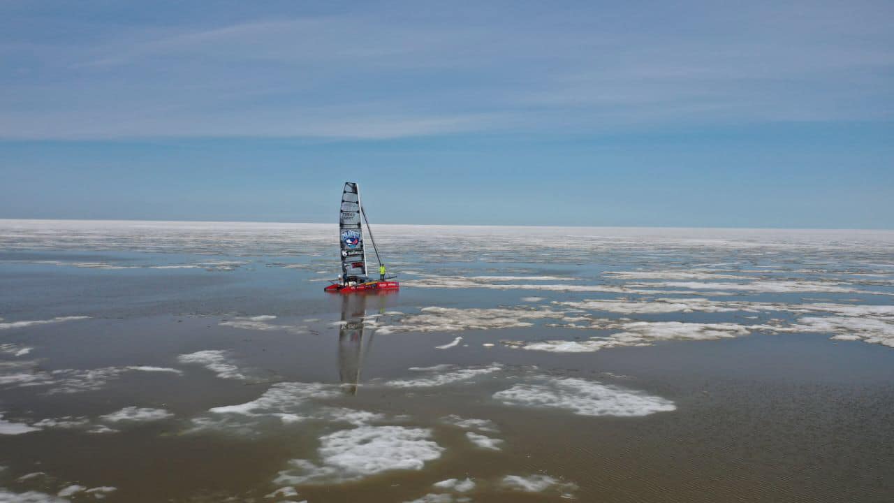
However Beto is sensibly waiting for conditions to improve before setting out on the “Rota Polar” expedition proper. Here’s the current state of play in the CAA according to AMSR2:
Beto has announced on his Facebook feed that he’s intending to depart tomorrow:
Heading out Tuesday afternoon for favorable wind conditions, but as far as the ice we already know we won’t be sluggish on our way to Paulatuk. We expect to arrive between 4-5 days
Auto Translated From the original Portuguese
It’s unlikely that he intends to take either of these two routes, but here’s a fairly clear view of the ice breaking up in the McClure and Prince of Wales Straits:
Here’s hoping Beto manages to squeeze past Cape Bathurst successfully, since that area is not yet covered by the Canadian Ice Service:
Igloo has successfully rounded Cape Bathurst and entered the Amundsen Gulf:

Not without encountering ice and fog en route however!
Meanwhile “passenger vessels” and “pleasure craft” are queuing up on the other side of the Canadian Arctic Archipelago:
The Marine Traffic map reveals that National Geographic Resolution has just entered Lancaster Sound.
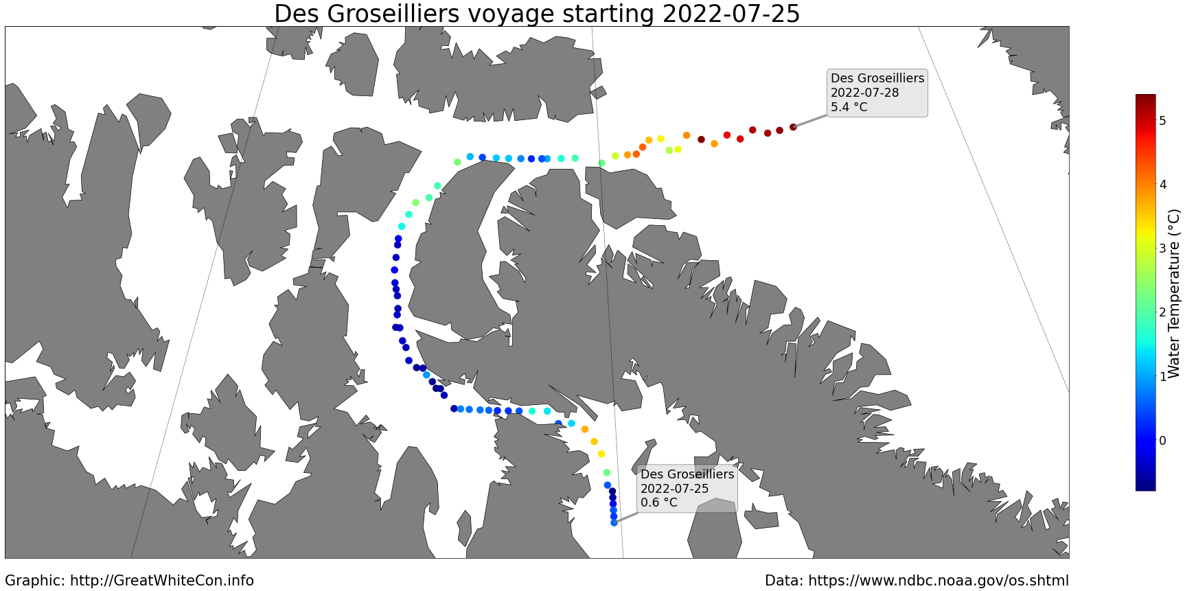
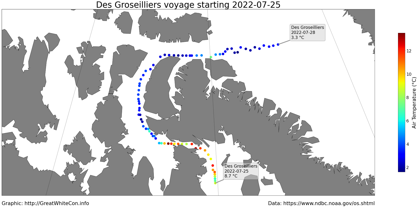
[Edit – July 28th]Canadian icebreaker CCGS Des Groseilliers has emerged into Baffin Bay after a voyage through the eastern Canadian Arctic Archipelago. Here are visualisations of both water and air temperatures measured along the way:
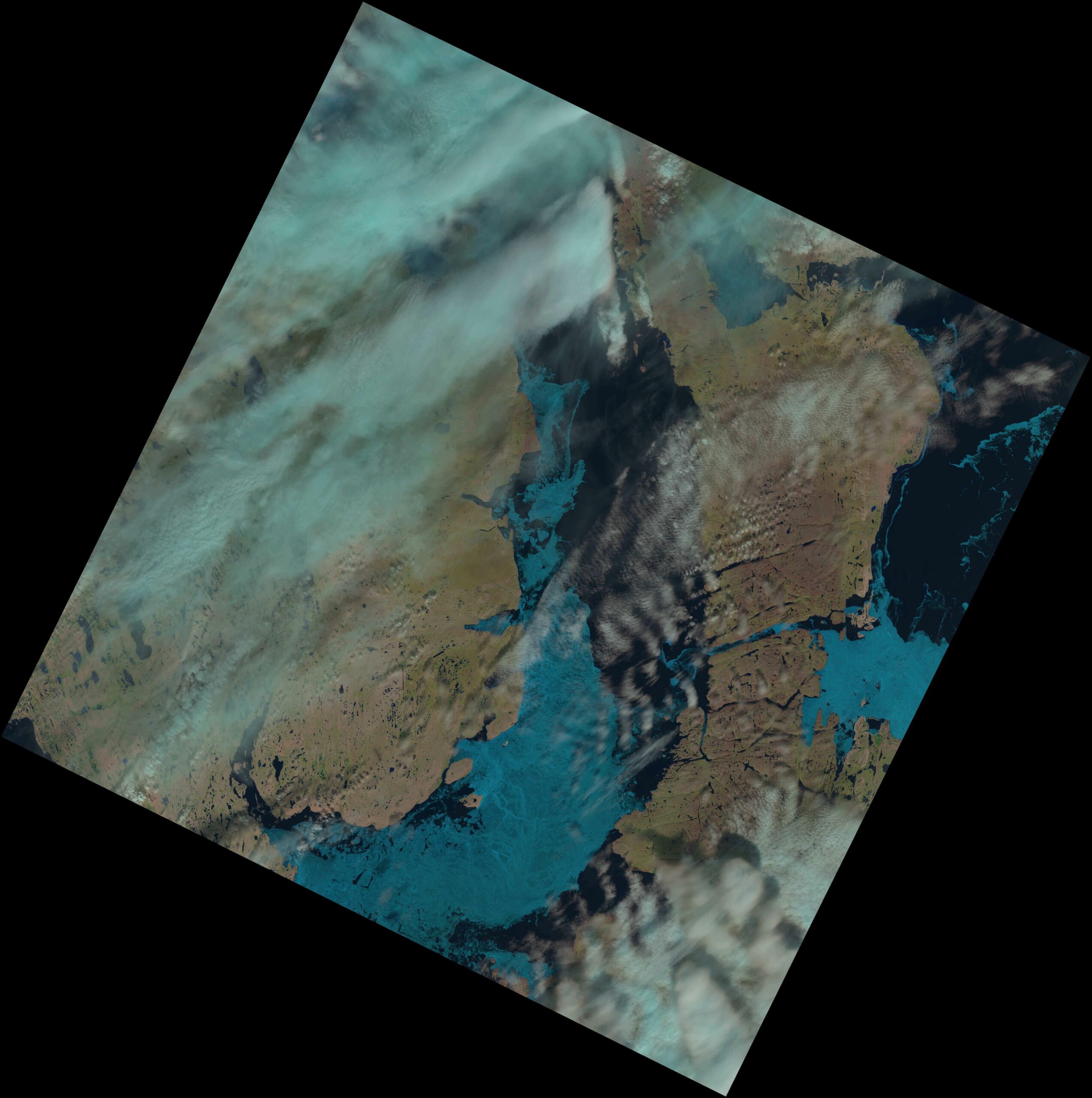
There was a clear satellite view of route 1 through the Northwest Passage via the Parry Channel yesterday. Click the image for a (much!) closer view:
Much of “Amundsen’s” route 6 was also visible. The troublesome patch of ice near Cape Bathurst is visible in the top left, but after that the way is clear as far as Gjoa Haven and beyond. And beyond that if you’re an ice hardened cruise ship!
[Edit – August 2nd]There is still no CIS coverage of Peel Sound, but the clouds parted over Bellot Strait yesterday:

Here too is the official chart for further south:
It looks as though the Northwest Passage will be “open” for “small craft” in the not too distant future, possibly via a variety of routes!
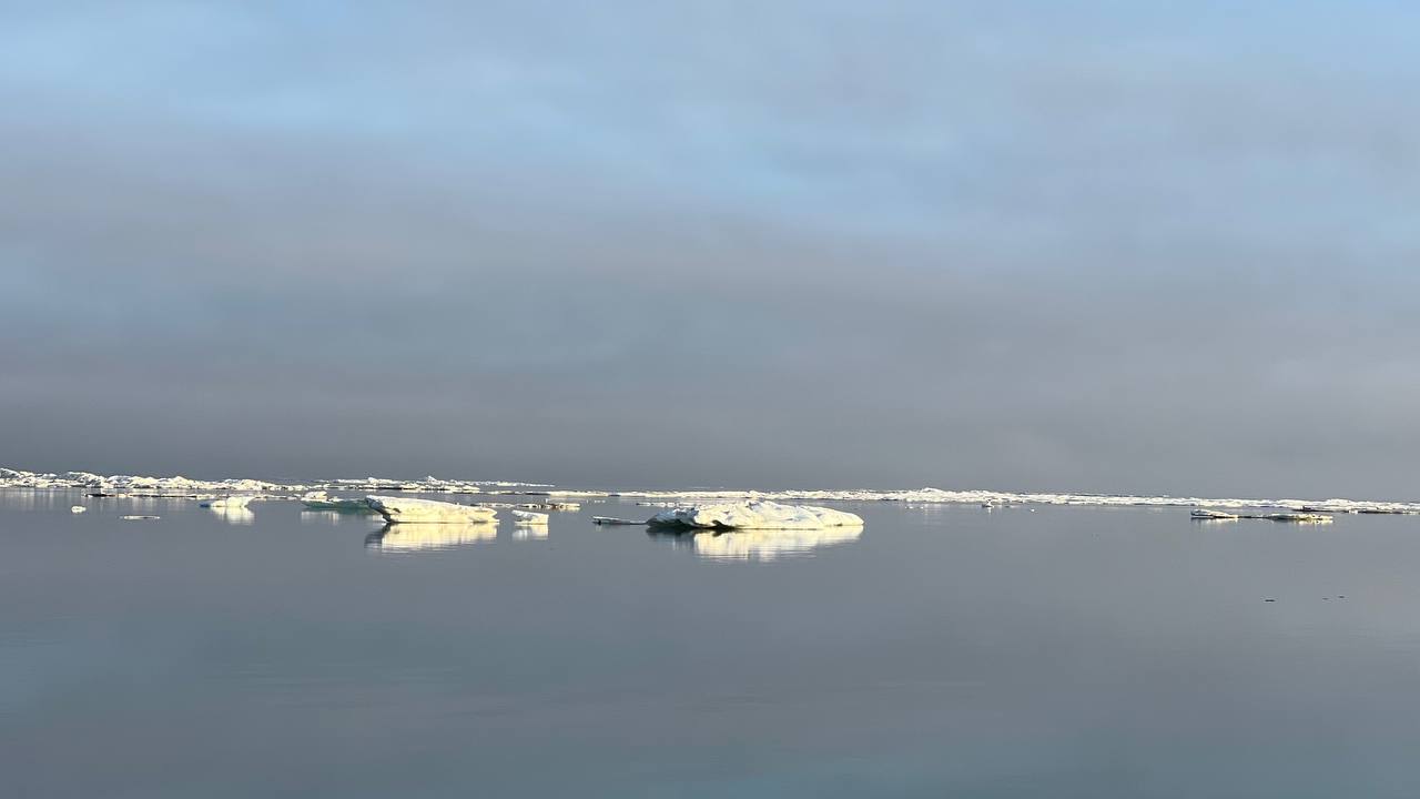
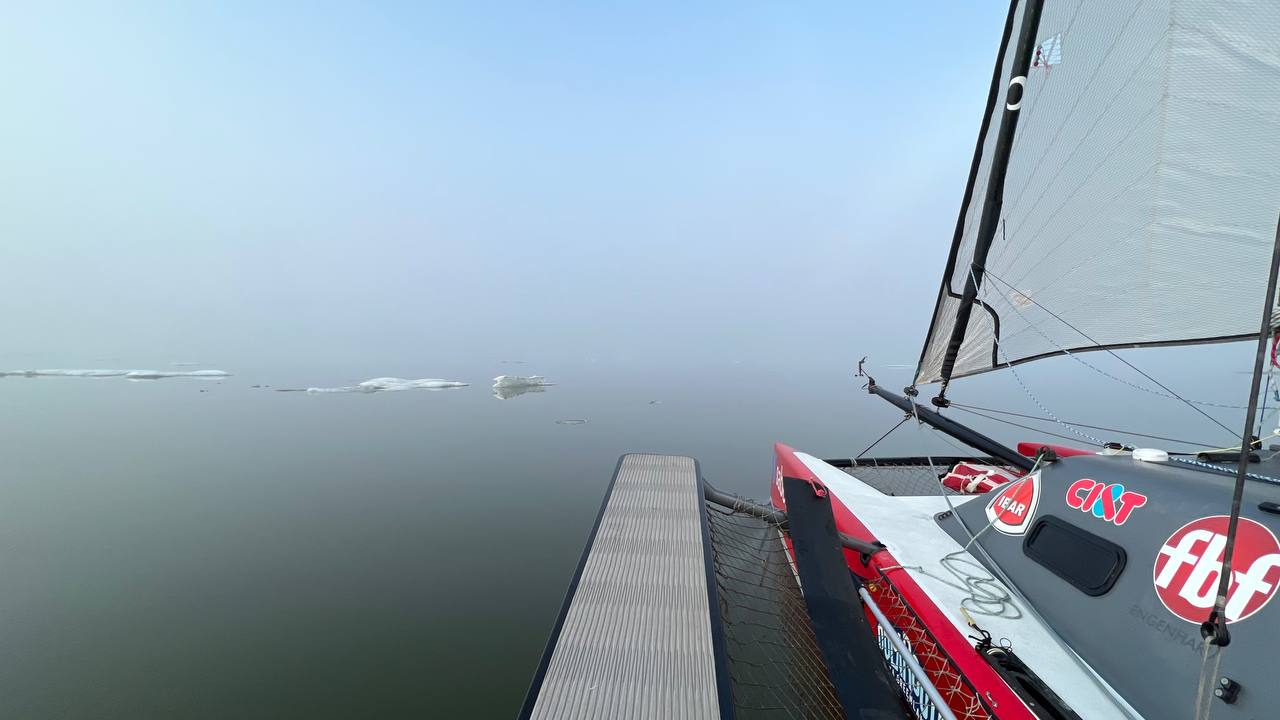
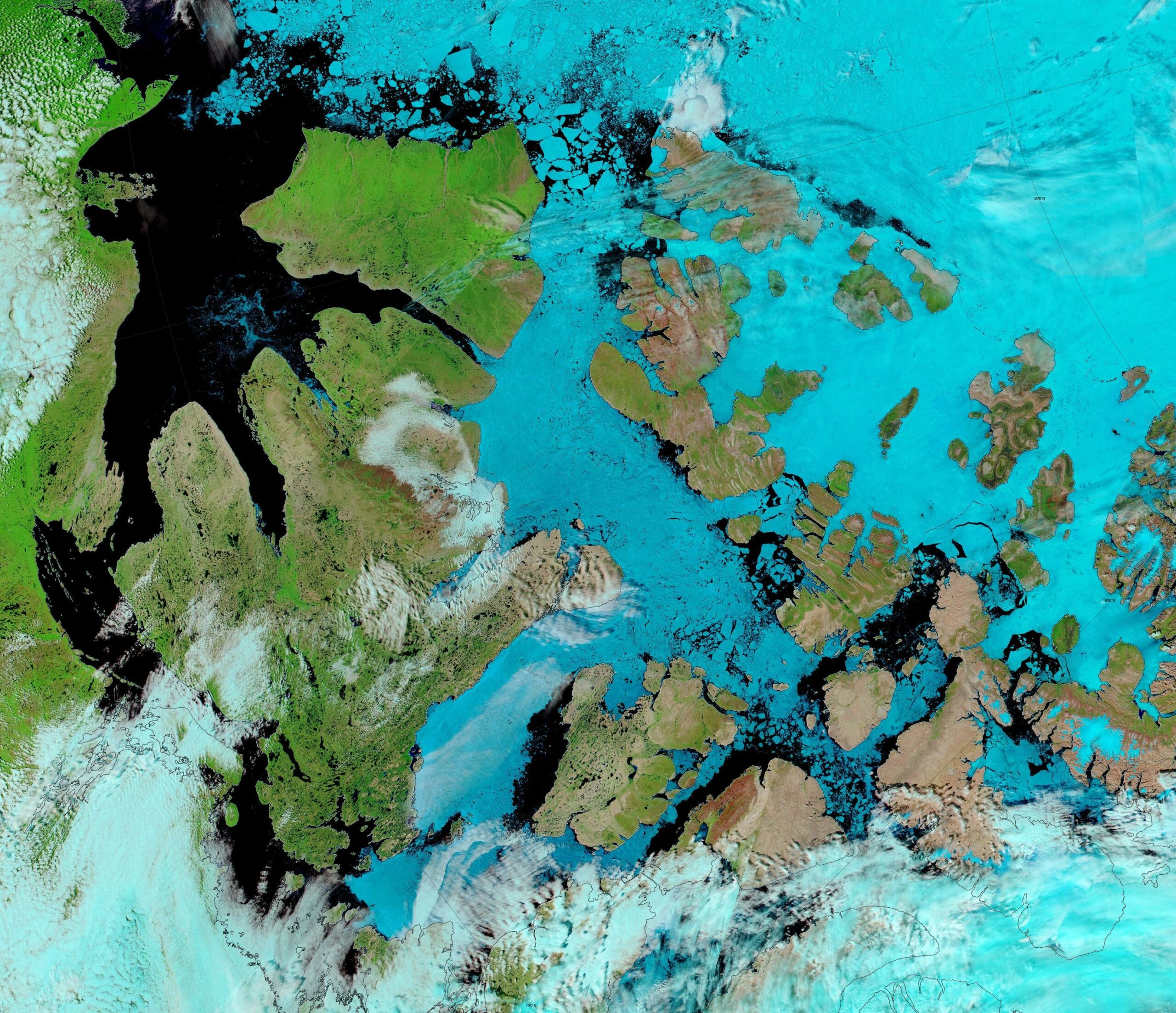
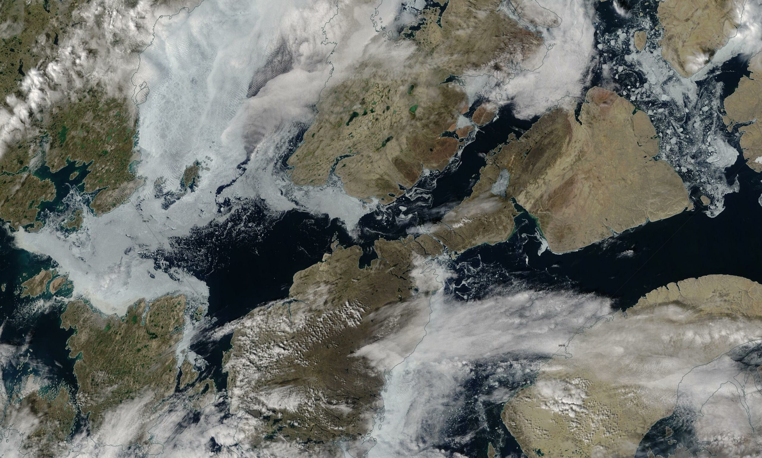
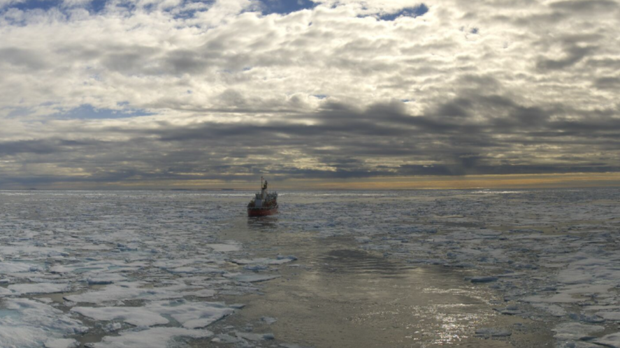
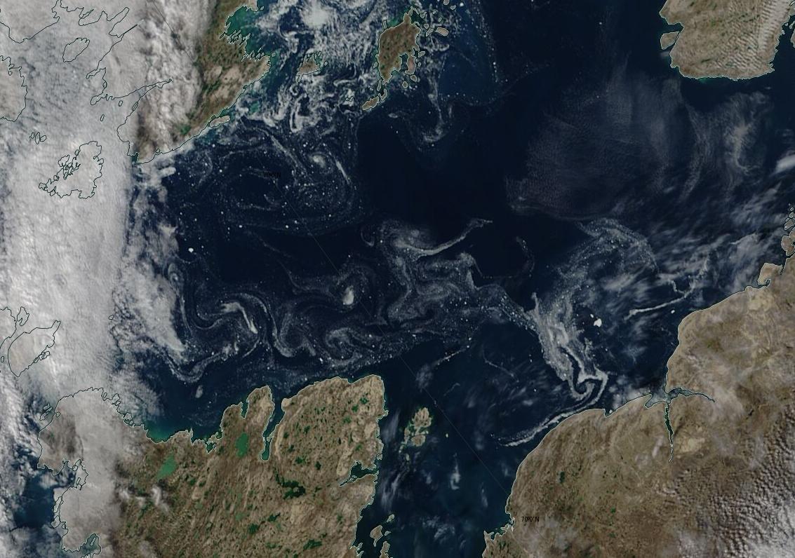
Meanwhile here are some recent pictures from the midst of Baffin Bay:
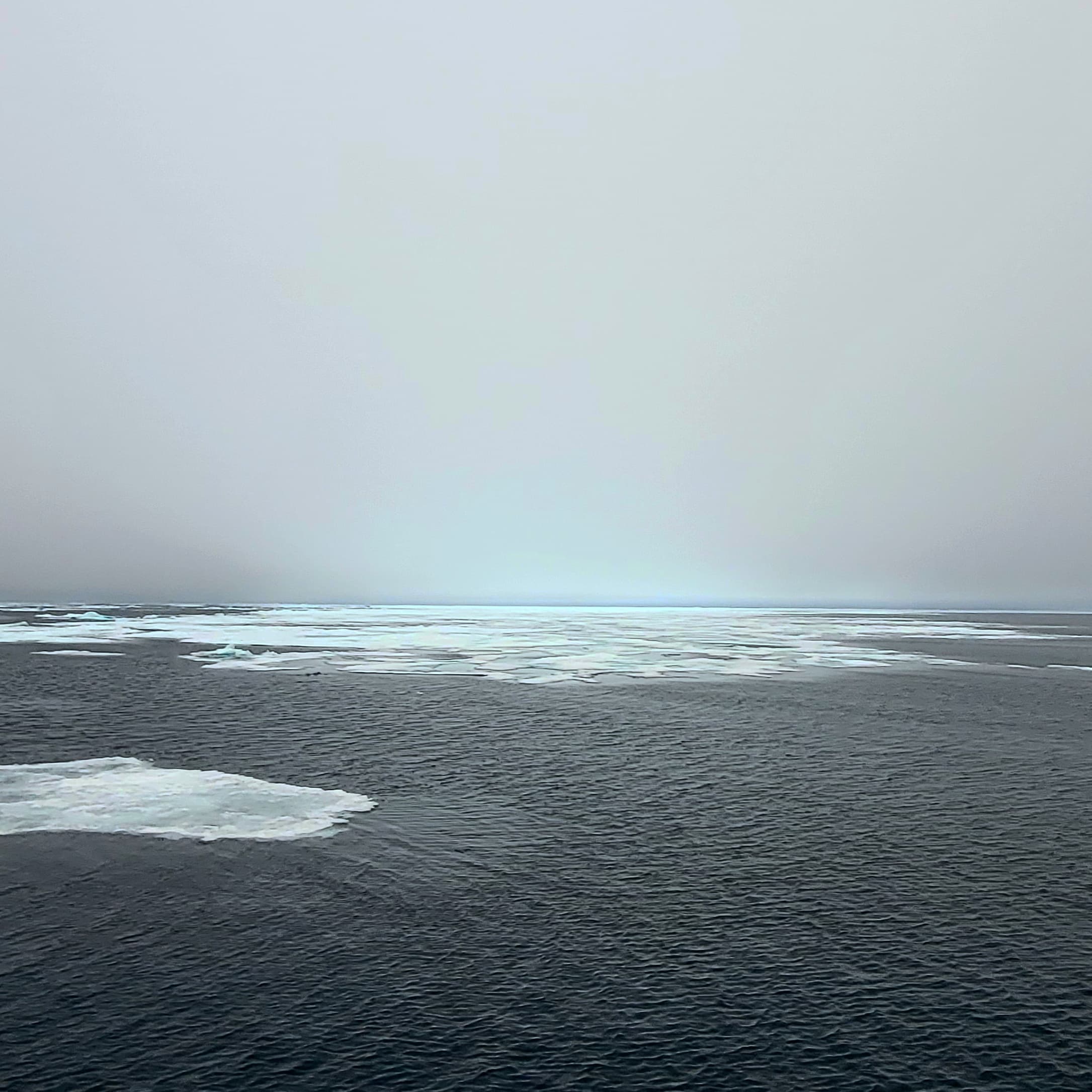
The sea ice in Baffin Bay has been replenished from the Central Arctic all winter, because the usual ice arches never formed in the Nares Strait this year. Here’s what it looks like bobbing about en route from Greenland to Pond Inlet:
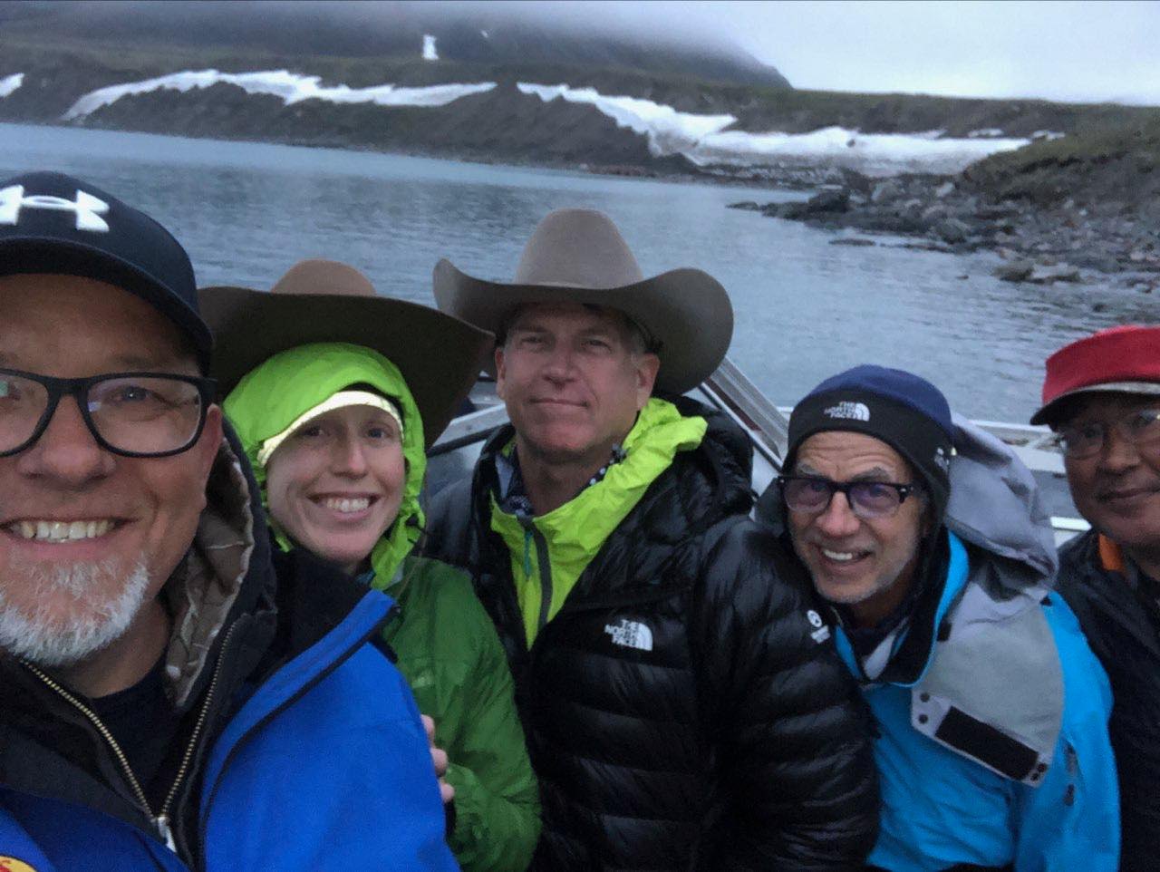
The Arctic Cowboys are on the move! After a variety of trials and tribulations Jeff, Rebekah and West are now paddling their kayaks through the Northwest Passage. According to their blog yesterday:
The Arctic Cowboys had a nice day of paddling with the wind at their backs. Final distance was about 13.7 miles. Heading out early in the morning after a little re-working of gear weight distribution.
Here’s a largely cloud free view of the central CAA from on high today:
The Bellot Strait is still the fly in the <= 6/10 concentration ointment. Nevertheless an adventurous “pleasure craft” is going to investigate:
STOP PRESS!!
The CIS started coverage of Peel Sound this evening (UTC):
It’s a tight squeeze, but using the <= 6/10 concentration criterion the Northwest Passage is open for small craft unusually early this year:
Mind you, here is a very recent example of allegedly 2/10 ice on routes 3/4:

Noorderzon is the first “pleasure craft” to transit Bellot Strait this year. It has done so remarkably early, and is now heading down Franklin Strait:
Meanwhile the flood of cruise ships is starting in earnest, with two nearing Pond Inlet as we speak:
SV Draco is already there, and no doubt currently plotting their own course through the central CAA.
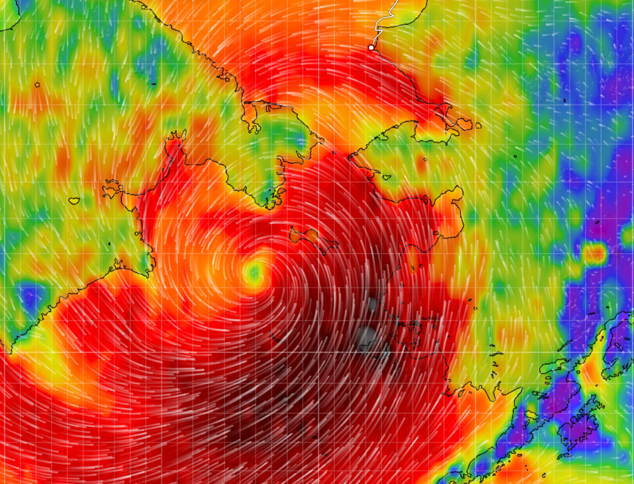
[Edit – August 10th]The GFS model is predicting a 978 hPa minimum MSLP cyclone over the Canadian Arctic Archipelago on Friday morning (UTC):
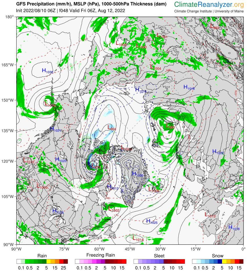
There will be plenty of wind and rain, so several “small craft” are already finding shelter from the forthcoming storm. See below!
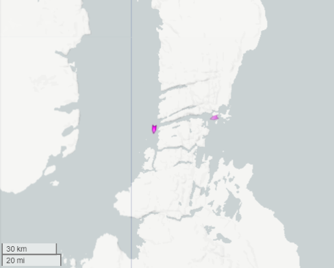
[Edit – August 14th]SV Draco has become the second “pleasure craft” to successfully transit Bellot Strait from east to west this summer. Here’s an extract from Draco’s tracking map:
There is much speculation about the possibility of Route 1 through McClure Strait being “open” this year. That may happen, but it hasn’t happened yet. Here’s Sentinel 1A’s view of things yesterday afternoon:

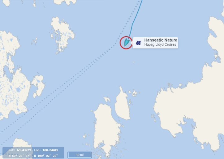
Hanseatic Nature is currently following CCGS Pierre Radisson through the remaining sea ice near the northern entrance to Victoria Strait:
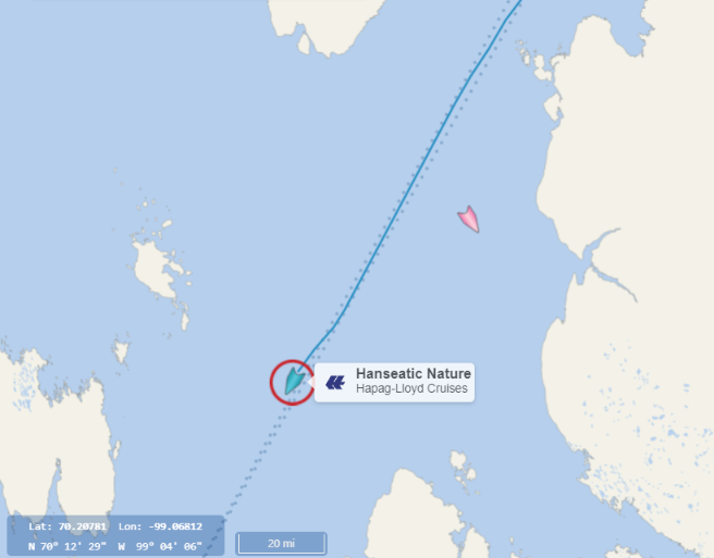
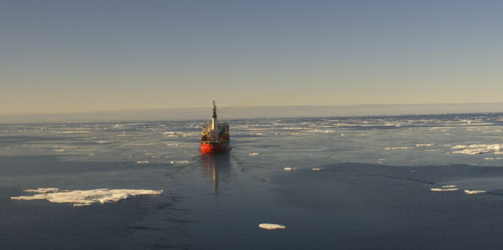
Here’s a recent snapshot from Nature’s webcam:
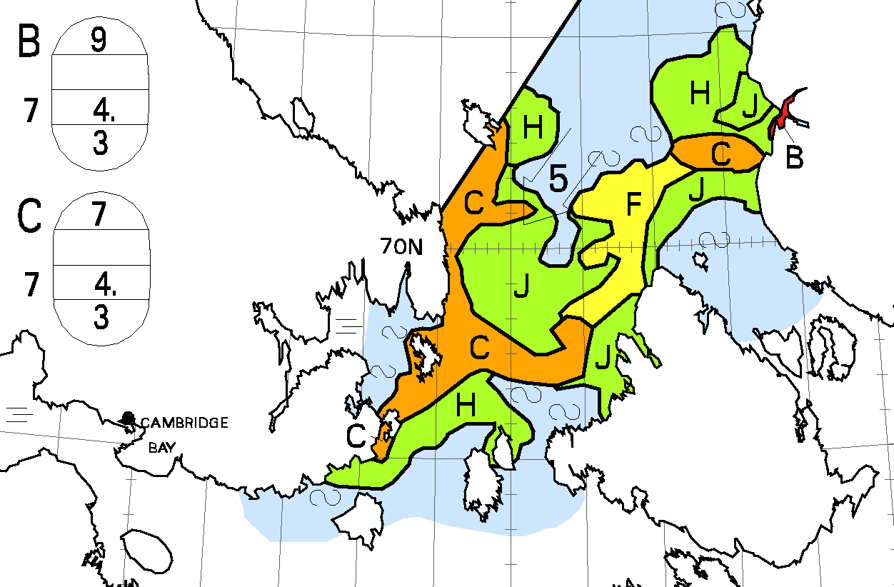
This allows comparison with other data, first of all last night’s CIS ice concentration chart:
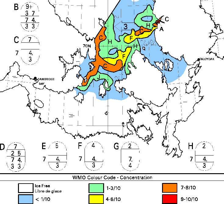
This classifies area H as mostly 2/10 concentration thick first year ice,
Another view of the area comes via the University of Hamburg’s high resolution AMSR2 concentration map:
This shows no sea ice at Hanseatic Nature’s current location, although part of the band of 7-8/10 ice on the CIS map is visible further south-west. The AMSR2 map also suggests that there is now a clear path along route 1 through the McClure Strait. More on that topic later.
[Edit – August 31st 21:15 UTC]Hanseatic Nature now looks to be crossing the band of 7/10 concentration ice in the Victoria Strait:
By way of additional information here is the latest CIS chart:
plus the view from Terra earlier in the day:
Unfortunately the view of the thickest ice is obscured by the clouds visible in the webcam image above.
[Edit – September 7th]The weekly Canadian Ice Service concentration chart reveals that route 1 through the Northwest Passage was “open” on September 5th, with a way through possible without encountering > 3/10 concentration sea ice:
Ex Typhoon Merbok is currently barrelling its way towards the Bering Strait generating huge waves and a large storm surge. See the September open thread and the comments below for further details, but this morning Mark Synnott in Polar Sun reports from the Chukchi Sea:
[Edit – September 25th]Storm of the Decade
This was the headline from the National Weather Service that someone just sent us. I guess information is power, but I think in this case I might have preferred not to hear every detail as to how serious a storm we are currently weathering…
The funny (or not so funny) thing was that the story actually mentioned Point Hope, where we are currently at anchor on the north side of the spit. Yesterday when we got here we nosed in as close to shore as we could get and anchored in about 20 feet of water. We have some protection from the southeast beneath a 20-foot bluff of crumbling permafrost, but I have never had to ride out a storm this big with so little shelter.Currently we’re seeing gusts over 30 and the snubber, to which I just added another layer of chafing gear, is creaking and groaning and generally letting it be known that it is under a tremendous strain…
The good news is that if we do drag, which I think is unlikely at this point, there is nothing but open sea downwind. And we pre rigged the third reef in the main so that if we lose our anchor, our plan is to heave to on the port tack and let this thing blow us out to sea…
It’s warm and cozy down here in the cabin and the motion aboard, which is not exactly mellow, is tolerable, at least for now. In a little while, I’ll check the snubber again and do another tour around the deck to make sure everything is properly buttoned up. Storm is supposed to peak tonight and tomorrow morning, so send us some good vibes, if you are so inclined.
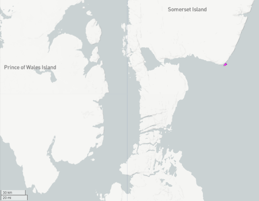
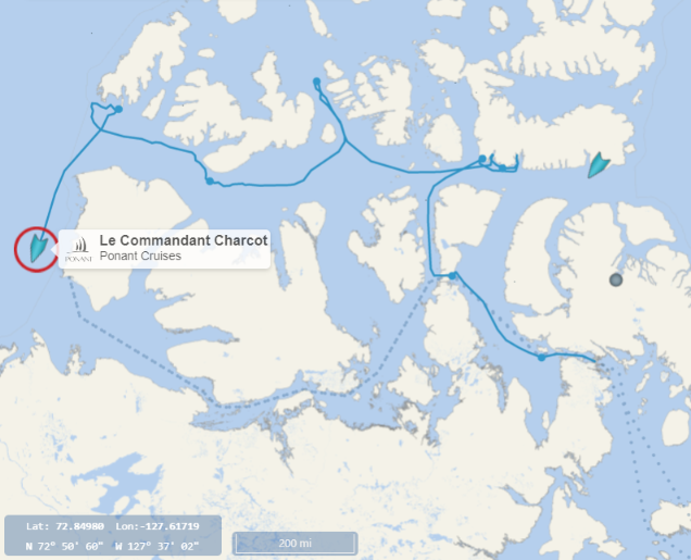
Le Commandant Charcot has caused a problem for the Scott Polar Research Institute. He has taken a route through the Canadian Arctic Archipelago that is not numbered on their map!
Voyaging from east to west he started on route 7, took an unusual northerly excursion, and then exited the CAA using route 1 through McClure Strait:
There is also another novelty for the Scott Polar Research Institute to record this year. Here is a picture of downtown Vancouver, kindly provided by Maiwenn Beadle who is the captain of the “pleasure craft” Noorderzon:
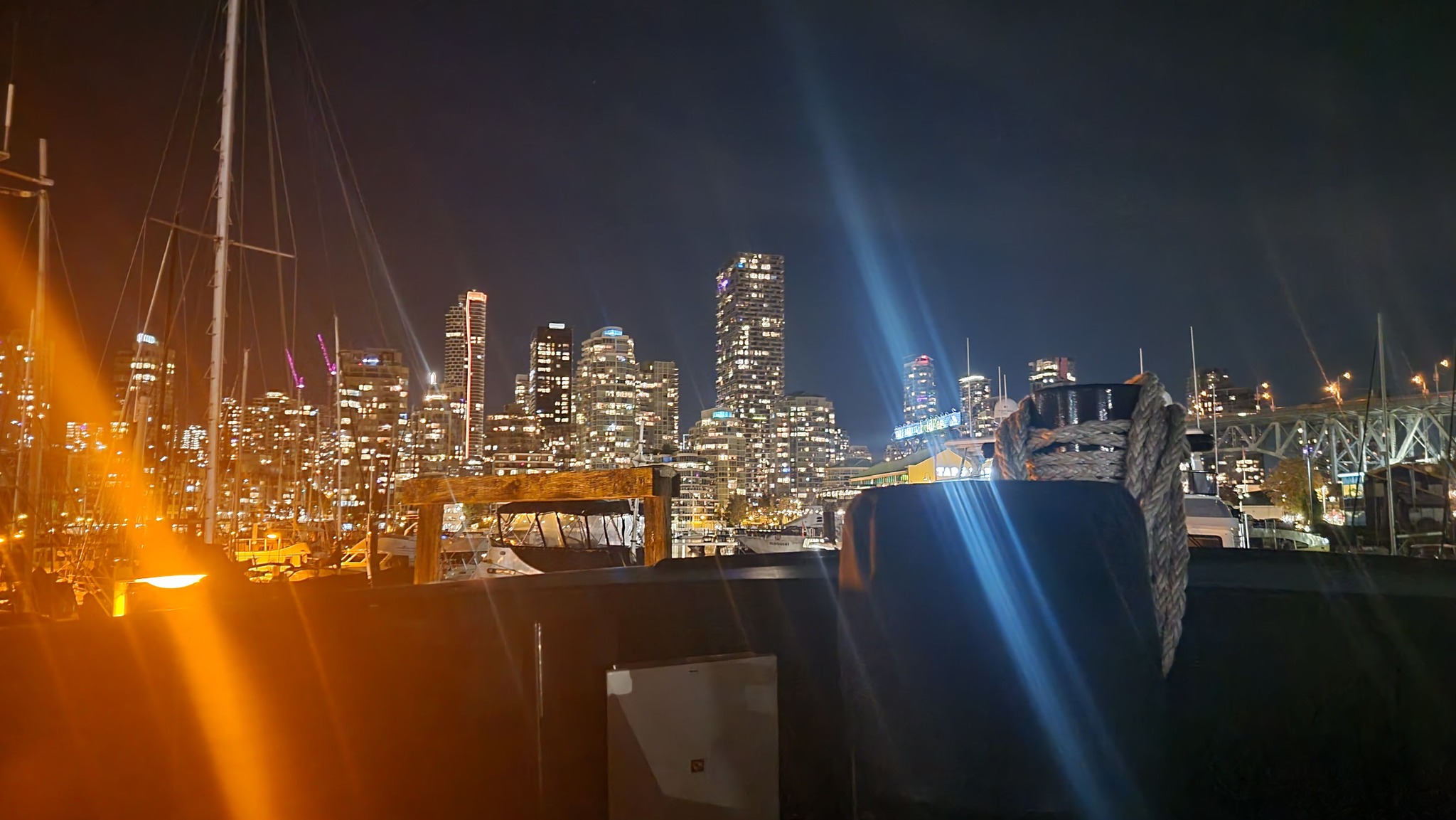
As far as I can ascertain Maiwenn is the first ever professional female captain of a vessel that has successfully negotiated the Northwest Passage. What’s more Noorderzon was the first “small craft” to achieve the feat in 2022!
Maiwenn assures me that she couldn’t have done it without the assistance of her amazing crew. She is now looking forward to a nice rest before deciding on her next adventure.
Watch this space!
It’s good to know that ‘climate change’ over the past 119 years has enabled small boats to once again make the Northwest Passage. Per Canadian Geographic:
“On September 9, 1903, Amundsen sailed into Simpson Strait, south of King William Island in Canada’s central Arctic. The strait was free of ice to the west, and while he could have continued through the Northwest Passage in only one season, he was looking for a good wintering place, having decided to stay for two years to take continuous readings of the North Magnetic Pole”.
His ship was 47 tons, crew of 6, considerably larger than these rowing expeditions, and they are benefiting from even shallower draft than the one meter draft of his vessel. Funny how much has changed in that 119 years, right?
These days “small boats” can circumnavigate the entire Arctic in one summer!
A slightly different interpretation of Gjøa’s voyage from the Fram Museum:
“It seems possible that the Gjøa could have sailed through the Northwest Passage in one season, because Simpson Strait was free from ice when the eastern entrance was reached on the 9th September.”
Not to mention:
“As early as September 2 [1905] progress was stopped at King Point, near Herschel Island, and within a week it was evident that another winter had to be spent in the Arctic. This time the Gjøa had much company because no fewer than 12 ships had been caught at Herschel Island.”
Would you care to play “Spot the difference”?
I’ll take “Spot the Difference” for $200, Alex (Tribute to ‘Jeopardy’).
Answer (as a question): “What is Summer of 1903, when the passage was open westward, and Summer 1905, when cooler, icier conditions closed the passage?”
In other words, by stopping to conduct his geomagnetic studies that winter of 1903-4, he missed the chance to go straight through. That’s climate variability for you. Maybe his climate models said it’s getting warmer every year, so he just assumed he could go anytime he wanted. Wouldn’t be the first person to be fooled by model results…/sarc
Oh, and BTW, Jim. I’m sure you remember that the Polar Ocean Challenge made that voyage in Summer 2016, a year that was famous for another event: the last Super El Niño. Lucky timing, that. We’ll see if anybody repeats the feat this year…
Please remind me when somebody eventually managed to repeat Amundsen’s feat.
Excellent question, Jim. After a bit of searching and reading accounts, I can’t find a story about who was second to cross straight through, as Amundsen did. Lots of references to 2012 and 2016, when folks thought it would be routine. I’ll keep looking, but if you know the answer, please point me to it.
As luck would have it I do Taylor. Henry Larsen in St. Roch made it west to east over 1940–1942:
https://en.wikipedia.org/wiki/St._Roch_(ship)
Wow, thanks for the reference. I note with special interest:
“ …first vessel to make a return trip through the Northwest Passage, traversing the more northerly route considered the true Northwest Passage, and was also the first to navigate the passage in a single season.”
So 1944 after the late 30’s-early 40’s global temperature rise, was the first known season since 1903 when a single-season transit was possible. Interesting that the ‘northern route’ was open – there must have been considerably less ice that year than recently, or wind patterns and the Beaufort Gyre weren’t operating as they do now. I’ll do a bit more digging…
The “more northerly route” taken by St. Roch was actually route 2 via Prince of Wales Strait.
In case you’ve forgotten, last year USCGC Healy sailed through the Prince of Wales Strait where sea ice was conspicuous by its absence and water temperatures were over 3 °C the whole way. What’s more CCGS Amundsen took quite a while to locate some sea ice in McClure Strait later in the season:
And your suggestion that “a single-season transit was possible” in 1903 is speculative to say the least!
I don’t blame Beto for hauling his boat to Tuktoyaktuk to “start” the Northwest Passage journey. Per some maps, there’s considerable amounts of thick ice near shore west of that point. His boat may get through if the eastward lower routes open up, but given the current ice conditions, it can hardly be called making the real Northwest Passage journey. Time will tell, I suppose.
Beto and Igor in Igloo has departed Tuktoyaktuk heading east. Here’s their current live tracking map:
It seems that when the wind drops Igloo possesses an auxiliary pedal propulsion system:
Meanwhile the CIS have still not initiated coverage of the Cape Bathurst area!
Igloo is nearing Cape Bathurst:
The CIS have still not initiated coverage of the Cape Bathurst area, but this slightly out of date RAMMB image suggests that there will be room to spare between the cape and the ice:
Igloo has reached Paulatuk:
According to Beto’s latest log entry:
The Cruise Mapper map reveals that National Geographic Resolution has entered Prince Regent Inlet, and is now inspecting Jackson Inlet on the Brodeur Peninsula of Baffin Island:
According to the latest Canadian Ice service chart that will have involved navigating through an area of 9/10 concentration ice:
This evening’s CIS charts reveal fast ice still blocking the western entrance to Bellot Strait:
Nevertheless National Geographic Resolution is still heading in that direction, and her sister ship National Geographic Endurance has now entered Lancaster Sound:
And there is still no CIS coverage of Cape Bathurst and thereabouts!
National Geographic Resolution is approaching the eastern entrance to Bellot Strait:
Resolution’s destination is currently listed as Depot Bay, so presumably this is as far as she will get through the Northwest Passage until later in the season.
Meanwhile further west Karl Kruger’s tracking map reveals that he has reached Inuvik:
Despite my former supposition, National Geographic Resolution is currently exploring Bellot Strait:
Meanwhile Karl Kruger is paddling out into the Beaufort Sea:
National Geographic Resolution is now en route to Gjoa Haven:
Karl Kruger appears to have parked his SUP on the beach north of Tuk, presumably in order to try and get some sleep:
Meanwhile it seems as though the Arctic Cowboys team are still stuck in Ottowa trying to get themselves and their gear flown to Pond Inlet:
National Geographic Endurance is now exploring Depot Bay, and presumably Fort Ross as well:
Meanwhile CCGS Des Groseilliers is heading north through the Gulf of Boothia.
The Arctic Cowboys and their kayaks have finally all arrived in Pond Inlet:
National Geographic Resolution has reached Gjoa Haven. Meanwhile her sister ship Endurance has made it through Bellot Strait:
National Geographic Resolution has reached Cambridge Bay, whilst Endurance is near Gjoa Haven:
Travelling in the opposite direction the “small vessel” Jaca is about to enter Canadian waters for the first time on its trip east:
Well, Jim, I should hope that Resolution got through! It’s a PC5 vessel: “PC 5: Year-round operation in medium first-year ice, which may include old ice inclusions”. In other words, fragmented ice should be no issue, since it can plow through medium first year ice even in winter. Far cry from the wooden ships of old, but a good idea for passenger safety. I’m sure other small boats will get through as well, since they can dodge any floating ice or hug the shore. NSIDC still gives the passage a reasonable possibility of opening in their August note, but doesn’t seem to be completely convinced.
I fear my comment about “ice hardened cruise ships” wasn’t awfully prominent?!
Perhaps the NSIDC were actually thinking of the “northern route” through McClure Strait? There is no doubt that the southern route will be open to all and sundry for quite some time this summer.
Whether SUPers and kayakers make it through remains to be seen however.
Jaca is still anchored in Demarcation Bay and Beto Pandiani’s “support boat” Fraternidade is making progress towards Canadian waters:
Comments on Jaca’s tracking map suggest she will be upping anchor and heading east later today:
Meanwhile Imaqa and Inook seem to be travelling in convoy, and have just rounded Point Barrow:
The CIS still haven’t started coverage of Cape Bathurst, where all these “small vessels” are heading. However a bit further ahead Amundsen’s route round King William Island via Gjoa Haven is already looking eminently navigable:
Hello,
Where did you find the info that Fraternidade is our support boat. This info I’m not correct so I would like to know the source and ask for correction.
Hi Igor,
Thanks very much for taking the time to pop in here! Things seem to going well for Igloo? Apart from the mast!
I linked to my source above, but here is where I found the evidently erroneous article in question:
Igloo has reached Kugluktuk:
The CIS covered Cape Bathurst last night (UTC)!
Here’s what the assorted “small craft” heading in that direction will have to contend with:
Karl Kruger seems to be resting on the beach at Cape Bathurst:
Meanwhile Igloo is entering the Coronation Gulf:
Further east Jaca and Fraternidade are nearing Tuktoyaktuk:
Imaqa and Inook have returned to the vicinity of Elson Lagoon:
There are a number of “pleasure craft” currently cruising around the Pond Inlet vicinity, but none of them have yet taken the plunge and set sail for Bellot Strait:
Karl Kruger has passed Cape Bathurst and is currently in a rather exposed position hugging the coast past the famous smoking hills:
Igloo on the other hand has found a sheltered spot in the Coronation Gulf:
National Geographic Resolution has passed Cape Bathurst and is heading west across the Beaufort Sea. Endurance is currently near Ulukhaktok on the west coast of Victoria Island:
Jaca remains in Tuktoyaktuk, but Fraternidade has pushed on past Cape Bathurst and will shortly be passing Karl Kruger:
The CIS still hasn’t started coverage of Peel Sound!
Things are looking tantalisingly close to opening up either side of Bellot Strait however:
There was a glimpse through the clouds over Bellot Strait once again today:
Still not quite there, and still no CIS coverage of Peel Sound!
Inook and Imaqa have just set off from Point Barrow once again:
Robert Youens set off from Tuk yesterday and has reached Cape Bathurst:
He reports that:
At this rate he will quickly catch up with Karl Kruger on his SUP, but it will be quite a while before he meets up with the Arctic Cowboys.
Karl Kruger is now ashore near Cape Parry:
A recent article from ExplorersWeb reveals that:
Robert Youens has reached Paulatuk:
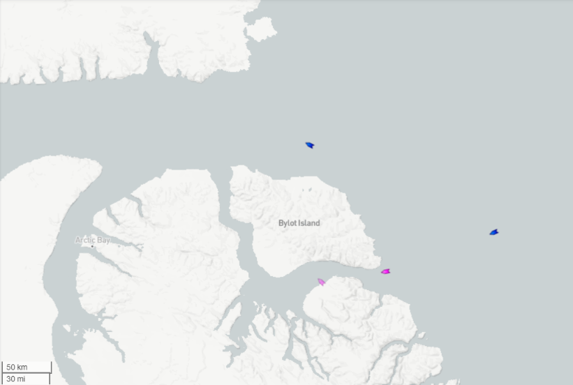
Heading in the opposite direction the Arctic Cowboys are paddling their way around Bylot Island:
Amongst the other “small vessels” heading east Fraternidade is nearing Cambridge Bay:
where Igloo remains after a multi-day stay:
Meanwhile Jaca has rounded Cape Bathurst:
and Inook and Imaqa are sheltering together at Herschel Island:
Noorderzon is the first “pleasure craft” of 2022 to successfully negotiate Bellot Strait heading west:
Arrived in Nome this morning aboard the NG Resolution. Awesome trip and first passage of the season. Once we got in, Bellot was clear of ice and full of Narwhals. Drone proved very useful in finding leads thru the ice. More pics and commentary @ orcella.org
[Added link – Mod]
Thanks very much for the pictures Ken! And for your interesting web site.
Do you mind if I post copies of the images on the Arctic Sea Ice Forum?
Jim. I don’t mind you using the pictures. The NG Endurance arrived here in Nome this morning which I assume is the second transit of the season. They we following a day behind us. We got into Bellot Strait just before an ice floe moving north blocked it and they had to wait a day or two around Fort Ross before theygot thru. The Endurance is heading back thru the passage tonight. There is also a 60 m yacht Blue Moon that has been anchored outside the harbor since we arrived and I wonder if they are planning on following the Endurance can’t think of another reason they would be this far north.
Looks like the yacht Blue Moon is heading to Cambridge Bay. They were in Nome when we arrived on the Resolution then entered the harbor to take on fuel after the Endurance left the pier and are now behind them.
Yup. Endurance in dark blue. Blue Moon in pink.
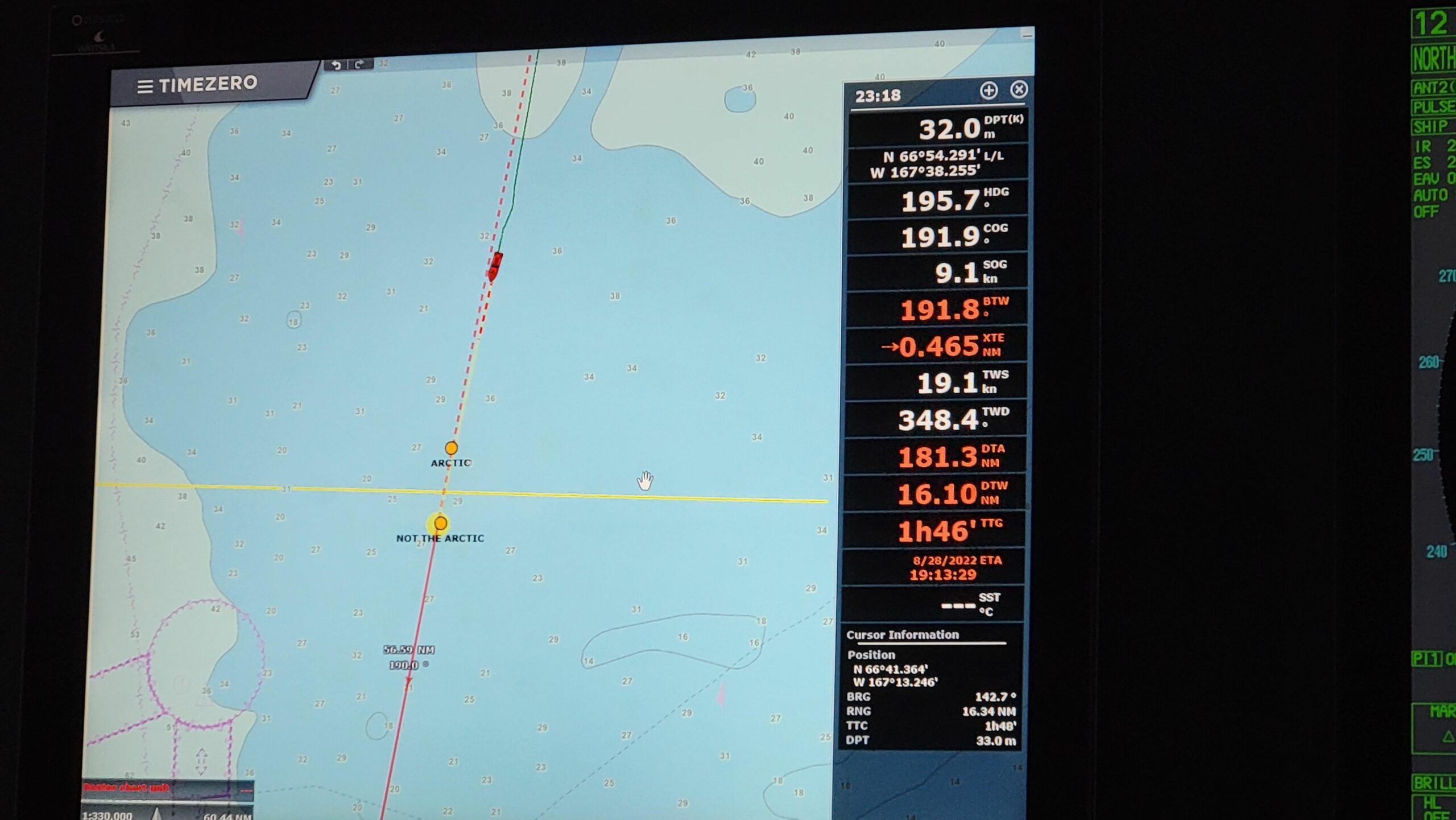
We are passengers on the Roald Amundsen . We board tomorrow in Vancouver BC
Thanks for the information Bob.
If you have the time, and an internet connection en route, please keep us posted on the Amundsen’s progress.
Karl Kruger has reached Paulatuk:
National Geographic Endurance has just left Nome for the return journey through the Canadian Arctic Archipelago:
Robert Youens has reached Kugluktuk:
Heading in the opposite direction the Arctic Cowboys are ashore on Baffin Island:
Somewhat belatedly I’ve just come across this report from Cabin Radio:
The National Geographic Resolution, voyaging between Greenland and Alaska, is no longer calling at the NWT community on Monday [August 1st]. Sister ship National Geographic Endurance is still expected in Ulukhaktok on Tuesday..
Denise Okheena, Ulukhaktok’s economic development officer and corporate manager, said the ship had reported 14 confirmed cases of Covid-19 and was asked not to arrive in Ulukhaktok for the community’s safety.
Beto reports that Igloo has met up with Fraternidade in Cambridge Bay:
I assume this is what he has in mind:
Noorderzon is nearing Gjoa Haven heading west:
Jaca is passing through the Dolphin and Union Strait:
According to their log from Bernard Harbour yesterday:
SV Draco has set sail from Pond Inlet, and is now heading north towards Lancaster Sound before heading west:
Imaqa and Inook have both rounded Cape Bathurst:
As a variety of “pleasure craft” remain in safe harbours, the Canadian icebreaker CCGS Henry Larsen is crossing Victoria Strait:
Meanwhile the latest CIS chart shows the western entrance to Bellot Strait is now free of 7/10 concentration sea ice:
Hence route 6 is officially “open” at last!
SV Draco has now entered Prince Regent Inlet, and is presumably heading for the eastern entrance to Bellot Strait:
Meanwhile Imaqa and Inook are braving the winds and approaching Jaca at anchor:
Draco is making progress towards Bellot Strait:
Jaca is now at sea once again:
Draco has reached Bellot Strait, and is currently waiting in Depot Bay:
Meanwhile SV Polar Sun’s tracking map reveals it has departed Pond Inlet and is now heading west along Lancaster Sound:
It has also been reported by 24Kurier.pl that Grzegorz Węgrzyn has reached Pond Inlet in Regina R. II on a single handed east to west voyage through the Northwest Passage.
News about the first “commercial” voyage through the CAA this summer:
Last year the first Royal Wagenborg vessel successfully made it through the CAA at the end of August:
https://GreatWhiteCon.info/2021/05/the-northwest-passage-in-2021/#comment-471711
Draco has reached Gjoa Haven as the wind picks up again in Rae Strait:
Meanwhile Polar Sun is the first “pleasure craft” of the summer to take the Peel Sound route south:
Taya has also now passed through Bellot Strait heading west, and has caught up with Polar Sun at Pasley Bay:
According to Mark Synnott on Polar Sun:
This is the current CIS ice concentration map for the area:
Draco heading west has passed Jaca heading east in Simpson Strait today:
Meanwhile Inook heading north managed to squeeze past the ice that drifted across the James Ross Strait:
We are on the Roald Amundsen. We should be in Nome tonight .
Thanks for the heads up Bob.
MS Roald Amundsen is now heading for the Bering Strait:
The cruise ships are coming!
National Geographic Endurance has now returned to Pond Inlet via Peel Sound:
Meanwhile Scenic Eclipse has just made it through Bellot Strait heading west:
Several small craft heading east are still waiting at Gjoa Haven for better weather. Further ahead Inook has now exited the CAA via Pond Inlet, and is now crossing Baffin Bay.
Draco is now making progress in a westerly direction:
Meanwhile Mae West has successfully negotiated Peel Sound:
Jaca, Imaqa and Fraternidade all left Gjoa Haven in convoy earlier today:
Igloo departed too, but doesn’t seem to be part of the convoy:
Polar Sun and Taya have finally managed to extricate themselves from the ice in Pasley Bay:
According to Polar Sun’s log:
Jaca has successfully negotiated Bellot Strait heading east:
Heading in the opposite direction Draco has rounded Cape Bathurst and reached the Beaufort Sea:
Igloo has made it through the ice that has drifted across Larsen Sound:
Auto translated from Beto Pandiani’s original Portuguese, here is his report from Larsen Sound:
Igloo has followed in Jaca’s footsteps and successfully negotiated Bellot Strait heading east:
Meanwhile Draco has reached Tuktoyaktuk heading west:
Mae West has left Gjoa Haven and made it through Simpson Strait:
Further north MS Fram is waiting in Depot Bay before heading west through Bellot Strait, with Hanseatic Nature not far behind:
Here’s a couple of snaps from Hanseatic Nature’s webcam. MS Fram setting off for Bellot Strait:
and Fort Ross from Depot Bay:
MS Fram is now safely through Bellot Strait. Hanseatic Nature is still in Depot Bay, with sister ship Hanseatic Inspiration heading in that direction:
Pierre Radisson and Hanseatic Nature have just entered another band of ice:
Mae West heading west has reached Cambridge Bay. Confirmed by this image from Hanseatic Nature’s webcam:
Meanwhile SV Jaca has reached Pond Inlet heading east:
Igloo is anchored at Port Leopold:
After visiting Fitzjames Island in Terror Bay Polar Sun has now joined Mae West in Cambridge Bay:
So has Roald Amundsen!
Cruise ships are now flocking towards the Northwest Passage. L’Austral is currently heading west through Bellot Strait:
Meanwhile Hanseatic Nature is now heading back east and has reached Pasley Bay, where Polar Sun and Taya were trapped in the ice a few days ago:
Also heading east is Roald Amundsen, now anchored at Gjoa Haven:
Amongst the smaller vessels Draco is approaching Point Barrow heading west:
Although her track doesn’t quite reach there, Igloo seems to have reached Arctic Bay earlier today:
P.S. Visual confirmation from Igloo!
Another report by 24Kurier.pl reveals that after Regina R. II suffered equipment failure Grzegorz Węgrzyn has returned to Pond Inlet after reaching Fort Ross:
Draco has rounded Point Barrow and is now heading for the Bering Strait:
Meanwhile Taya (pretty in pink) is nearing the Beaufort Sea:
As indeed is Trinityborg (gorgeous in green) en route to Taiwan with a commercial cargo. Also currently heading west are Mae West:
and Polar Sun:
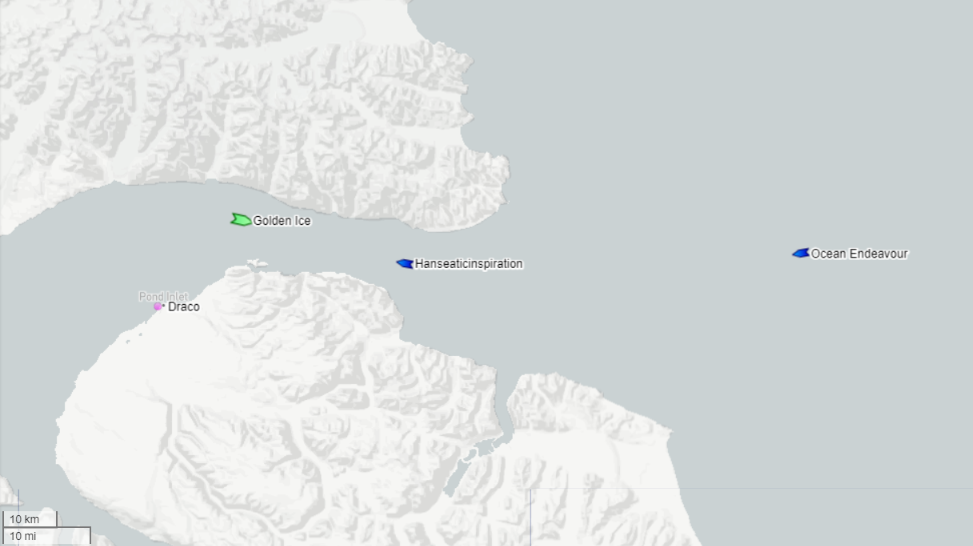
CruiseMapper reveals a selection of ships currently cruising the CAA:
From south-west to north-east there is Silver Wind, L’Austral, Ocean Endeavour, Greg Mortimer passing Fram, Roald Amundsen, Hanseatic Nature and Quark Ultramarine.
Draco has reached Nome, and hence become the second “pleasure craft” this year to complete an east to west transit of the Northwest Passage, including crossing the Arctic Circle twice:
Draco has (hopefully!) managed to avoid the worst of the storm currently raging in the Bering Sea:
As ex Typhoon Merbok heads for the Bering Strait Draco has reached some shelter off Unimak Island in the Aleutians:
Meanwhile the much larger L’Austral and Silver Wind appear to be riding out the storm in Port Clarence Bay:
Le Commandant Charcot is at an unusually northern latitude for a transit of the Northwest Passage!