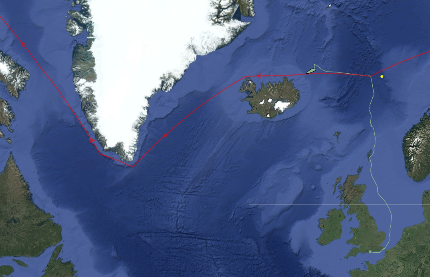
I mentioned the start of Ella Hibbert‘s long voyage in her yacht Yeva over on this year’s Northwest Passage thread. Ella and Yeva have now crossed north of the Arctic Circle near Iceland and have begun their attempt to circumnavigate the Arctic in a single summer by sailing past the north of Iceland in a westerly direction:
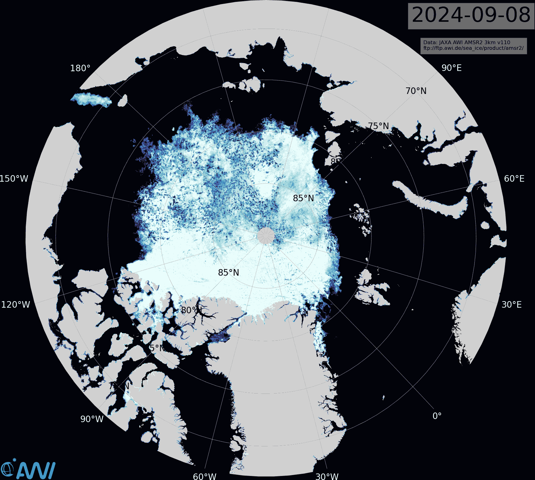
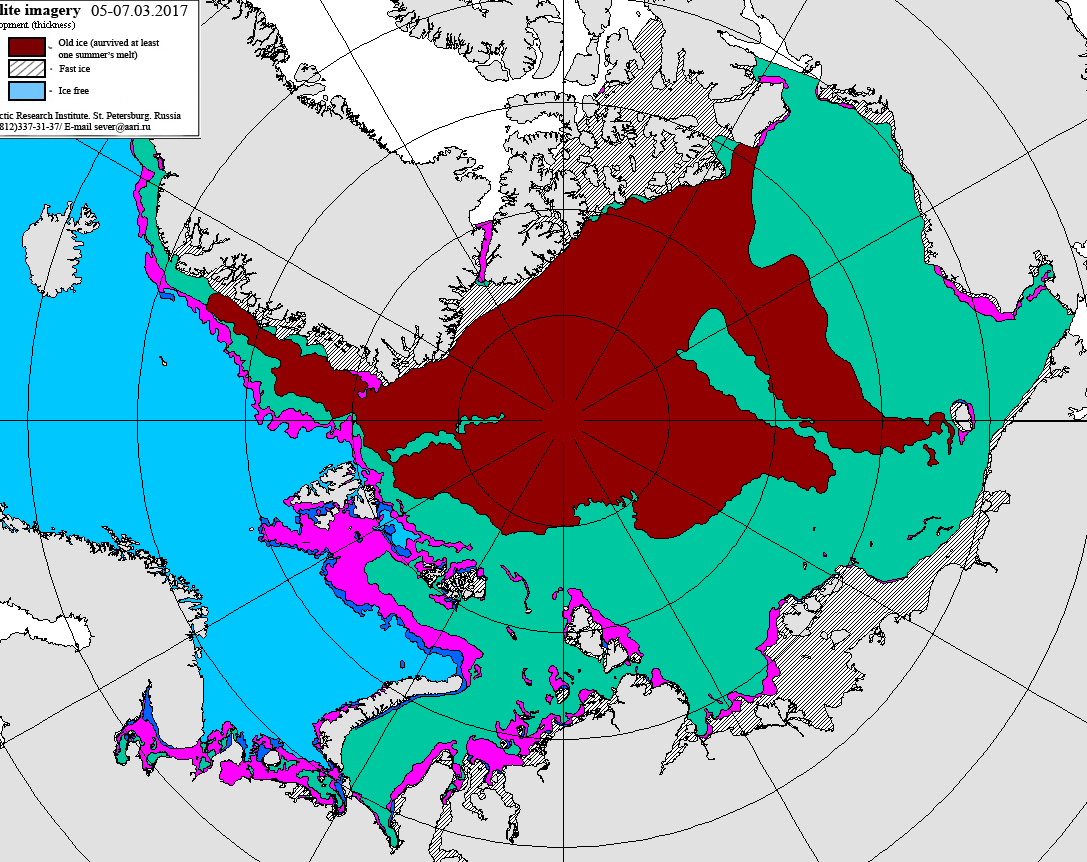
The JAXA extent graph is currently not updating, so let’s begin this month with the latest AMSR2 sea ice concentration map from the Alfred Wegener Institute. Click the image to see a ~10 Mb animation of the last four weeks:
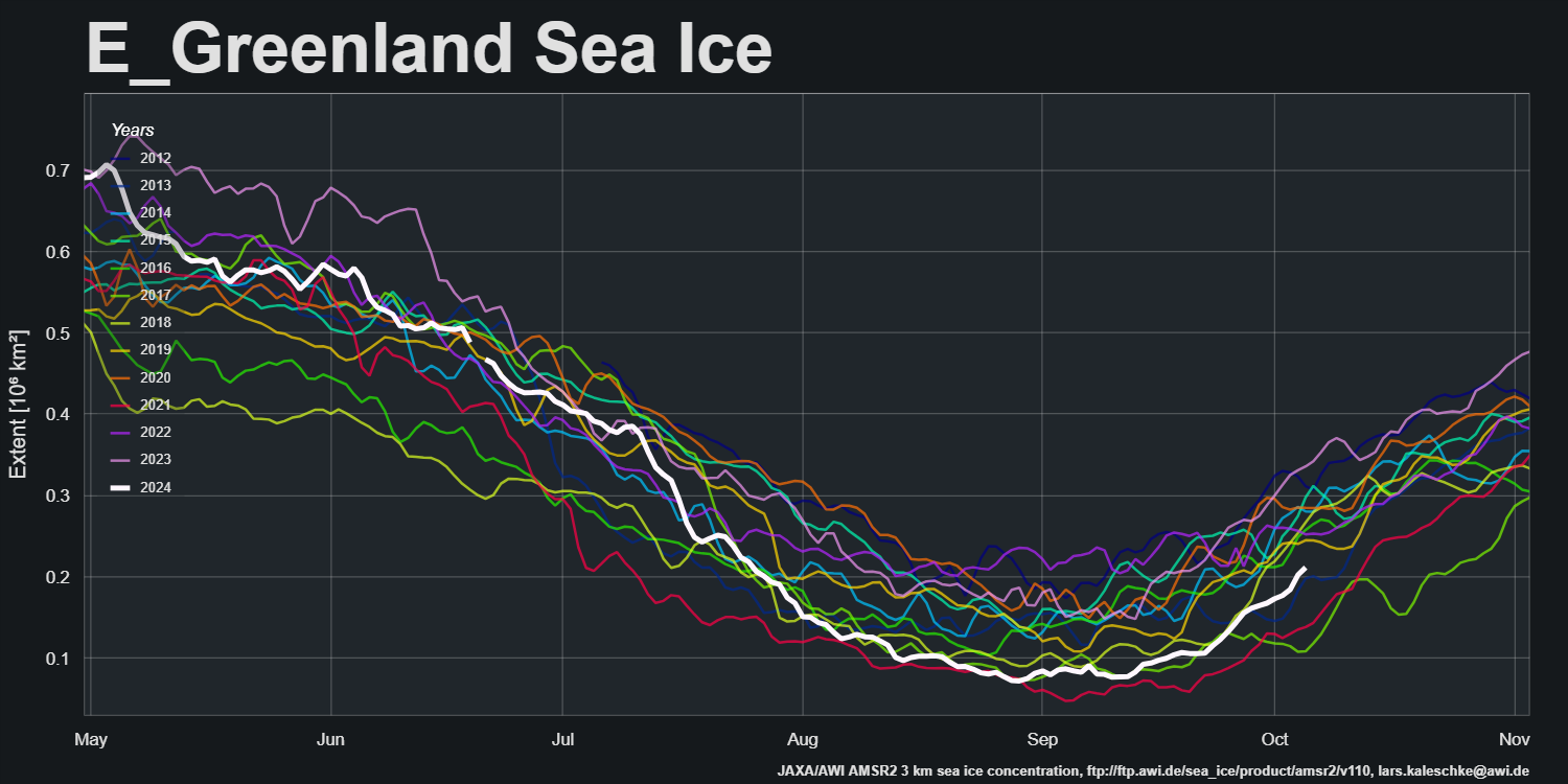
Note in particular the restart of export into the East Greenland Sea via the Fram Strait:
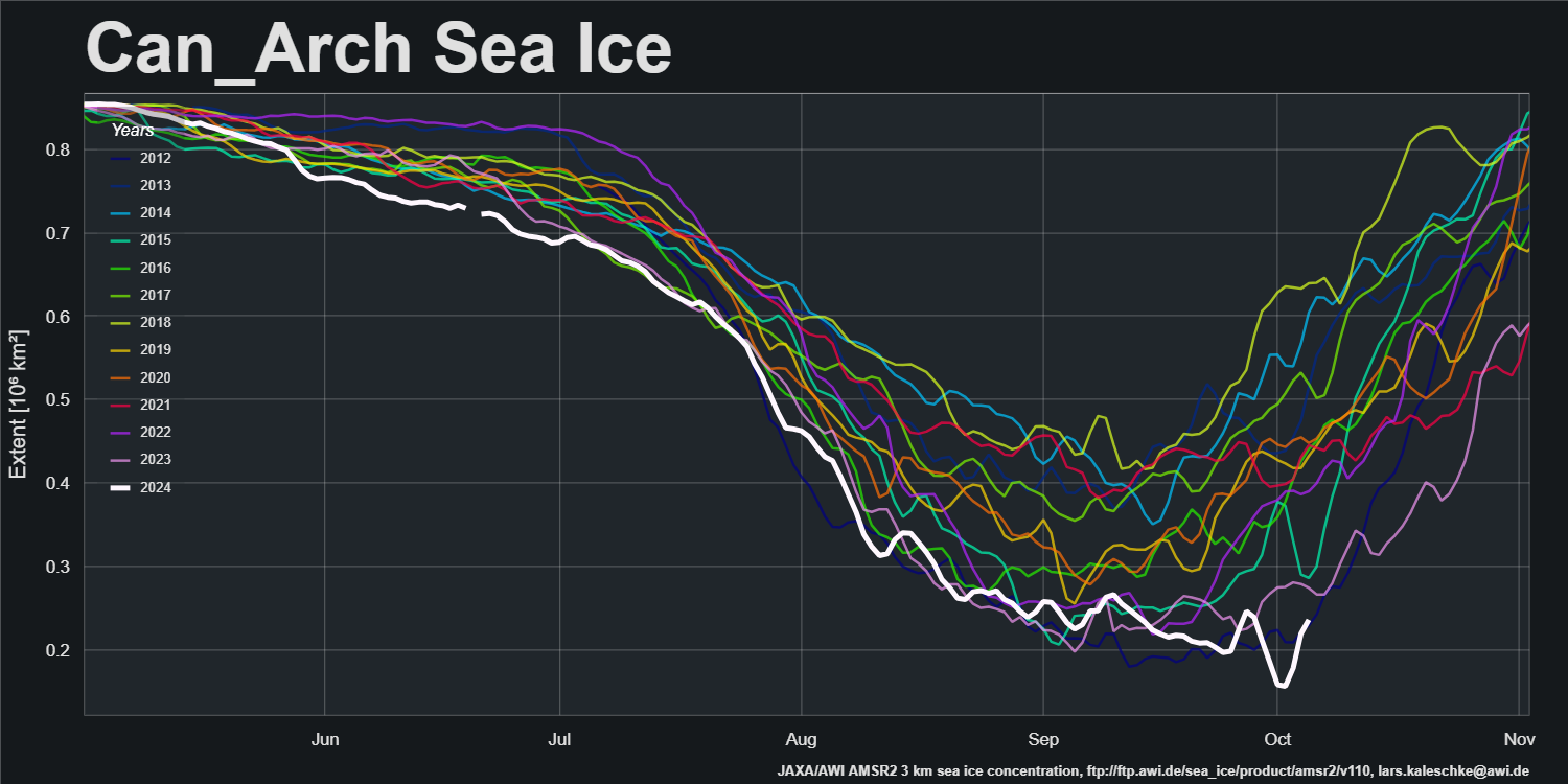
and the movement of ice within the Canadian Arctic Archipelago:
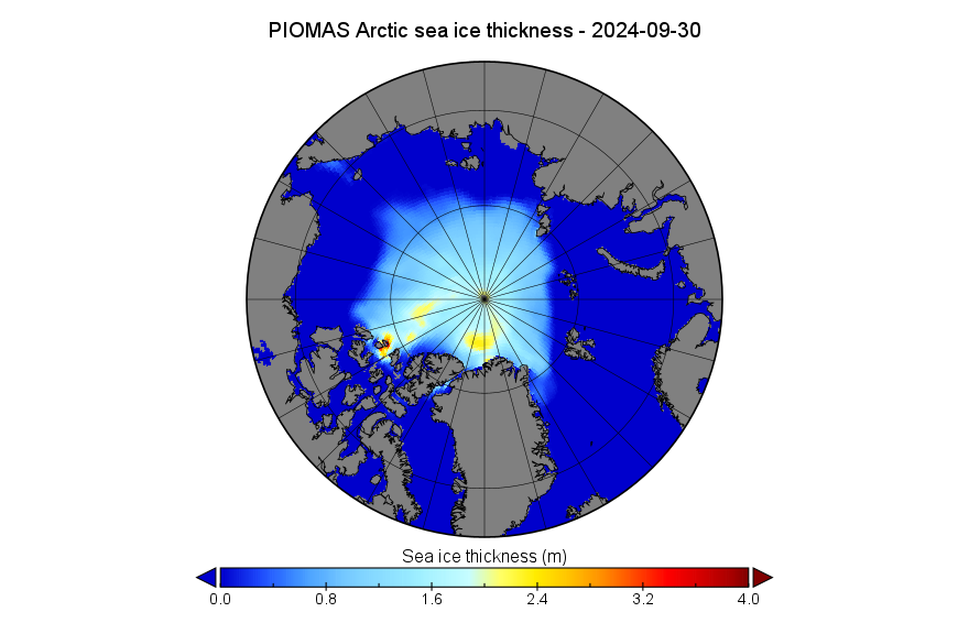
The PIOMAS gridded thickness data for September 2024 has been released:
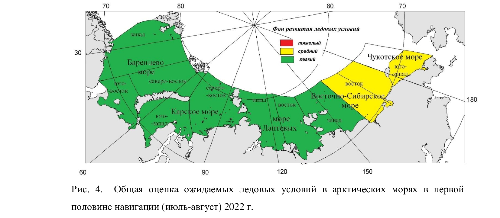
On June 17th the Northern Sea Route Administration published the Arctic and Antarctic Research Institute forecast of ice conditions for June to August 2022. Here’s the summary:
“Favorable” conditions in most areas, but “average” in the eastern East Siberian Sea and south west Chukchi Sea.
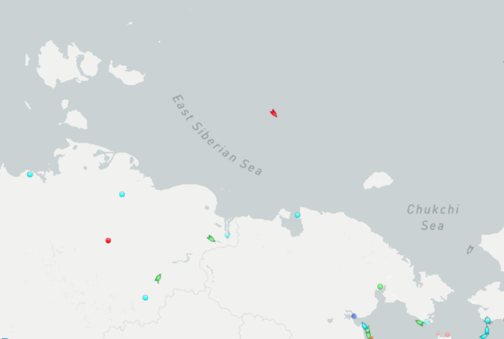
Traffic along the main Northern Sea Route has already begun. Marine Traffic reveals that the liquified natural gas carrier Nikolay Yevgenov is heading for the Bering Strait and has already sailed north of the New Siberian Islands. He is now entering the “average” ice area in the eastern ESS:
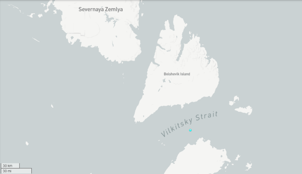
Meanwhile the recently commissioned nuclear powered icebreaker Sibir is patiently waiting in the Vilkitsky Strait:
The Northern Sea Route is evidently already “open” for ice hardened LNG tankers, but not yet for more conventional vessels. Here is the current AMSR2 sea ice concentration map:
Back in 2013 I sat around a table with the Chinese delegation during lunch at the Economist’s Arctic Summitin Oslo. In the evening there was a reception with the British Ambassador to Norway, where amongst other people I met Kevin Vallely.
Fast forwarding to July 2021, the Chinese icebreaker Xue Long 2 (which translates to Snow Dragon 2) set sail from Shanghai to do some research in the Central Arctic Basin:
According to a report by the China Global Television Network (CGTN):
The expedition plans to monitor sea, marine ice, atmosphere, microplastics and ocean acidification in the high seas of the Arctic through navigation observation, cross-sectional survey and satellite remote sensing to obtain hydrological, meteorological and biological data of the region.
It will also conduct scientific surveys in the Gakkel Ridge in the Arctic Ocean to learn about the formation of rocks and magma and the geomorphic features there to further enhance knowledge of the natural environment in the North Pole.
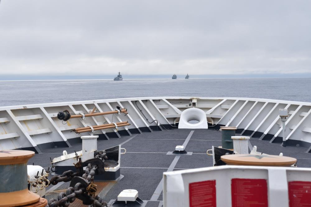
The U.S. Coast Guard demonstrated its commitment to the Bering Sea and Arctic region with deployments of national security cutters Bertholf and Kimball, and a U.S. Arctic patrol by icebreaker Healy.
“Security in the Bering Sea and the Arctic is homeland security,” said Vice Adm. Michael McAllister, commander Coast Guard Pacific Area. “The U.S. Coast Guard is continuously present in this important region to uphold American interests and protect U.S. economic prosperity.”
Crews interacted with local, national and international vessels throughout the Arctic. During the deployment, Bertholf and Kimball observed four ships from the People’s Liberation Army Navy (PLAN) operating as close as 46 miles off the Aleutian Island coast. While the ships were within the U.S. exclusive economic zone, they followed international laws and norms and at no point entered U.S. territorial waters.
The PLAN task force included a guided missile cruiser, a guided missile destroyer, a general intelligence vessel, and an auxiliary vessel. The Chinese vessels conducted military and surveillance operations during their deployment to the Bering Sea and North Pacific Ocean.
All interactions between the U.S. Coast Guard and PLAN were in accordance with international standards set forth in the Western Pacific Naval Symposium’s Code for Unplanned Encounters at Sea and Convention on the International Regulations for Preventing Collisions at Sea.
Now comes more news via CGTN, which according to YouTube “is funded in whole or in part by the Chinese government”, that:
Chinese captain Zhai Mo’s sailing boat is currently on the Northwest Passage of the Arctic Ocean.
According to the CGTN video it was “streamed live on Sep 15, 2021” from “Ilulissat, Denmark”. Then on September 16th CGTN reported that:
Canada has illegally stopped Chinese captain Zhai Mo and his crew while circumnavigating their sailboat in the Arctic Ocean near Lancaster Sound, a part of the northwest passage.
The United Nations defines the “right of innocent passage” as a vessel’s right to enter and pass through another’s territory as long as it is not prejudicial to the peace, good order or security of the other state.
Ilulissat is of course a long way from Denmark, and also a considerable distance from Lancaster Sound. Which perhaps explains why CBC reported on September 17th that:
Canadian officials are disputing reports in Chinese media that a famous sailor from that country attempting to circumnavigate the Arctic was turned back in the Northwest Passage…
Transport Canada told CBC News in an email on Friday that it was aware of Zhai’s vessel, but said “at this point, it has not entered Canada’s Arctic Waters.” The Northwest Passage has been off limits to foreign pleasure craft since March 2020 due to an interim order from the Canadian government intended to limit the risk of introducing COVID-19 in remote Arctic communities.
Transport Canada said it was in touch with Zhai via email to inform him of the rule.
“Transport Canada has since seen public reports that Captain Zhai Mo no longer plans to pass through Canadian Arctic waters and the department continues to monitor the situation,” the department said in a second statement to CBC News on Friday evening.
It seems to me that no longer planning to pass through Canadian Arctic waters is very prudent on Zhai Mo‘s part, since navigating the Northwest Passage without support from Xue Long 2 or a Canadian icebreaker is currently fraught with difficulty:
[Edit – September 21st]
By way of some additional background information, on January 26th 2018 China published a “white paper” on China’s Arctic Policy:
China is an important stakeholder in Arctic affairs. Geographically, China is a “Near-Arctic State”, one of the continental States that are closest to the Arctic Circle. The natural conditions of the Arctic and their changes have a direct impact on China’s climate system and ecological environment, and, in turn, on its economic interests in agriculture, forestry, fishery, marine industry and other sectors.
China is also closely involved in the trans-regional and global issues in the Arctic, especially in such areas as climate change, environment, scientific research, utilization of shipping routes, resource exploration and exploitation, security, and global governance. These issues are vital to the existence and development of all countries and humanity, and directly affect the interests of non-Arctic States including China. China enjoys the freedom or rights of scientific research, navigation, overflight, fishing, laying of submarine cables and pipelines, and resource exploration and exploitation in the high seas, the Area and other relevant sea areas, and certain special areas in the Arctic Ocean, as stipulated in treaties such as the UNCLOS and the Spitsbergen Treaty, and general international law. As a permanent member of the UN Security Council, China shoulders the important mission of jointly promoting peace and security in the Arctic. The utilization of sea routes and exploration and development of the resources in the Arctic may have a huge impact on the energy strategy and economic development of China, which is a major trading nation and energy consumer in the world. China’s capital, technology, market, knowledge and experience is expected to play a major role in expanding the network of shipping routes in the Arctic and facilitating the economic and social progress of the coastal States along the routes. China has shared interests with Arctic States and a shared future with the rest of the world in the Arctic.
Followed by:
The Arctic shipping routes comprise the Northeast Passage, Northwest Passage, and the Central Passage. As a result of global warming, the Arctic shipping routes are likely to become important transport routes for international trade. China respects the legislative, enforcement and adjudicatory powers of the Arctic States in the waters subject to their jurisdiction. China maintains that the management of the Arctic shipping routes should be conducted in accordance with treaties including the UNCLOS and general international law and that the freedom of navigation enjoyed by all countries in accordance with the law and their rights to use the Arctic shipping routes should be ensured. China maintains that disputes over the Arctic shipping routes should be properly settled in accordance with international law.
China hopes to work with all parties to build a “Polar Silk Road” through developing the Arctic shipping routes. It encourages its enterprises to participate in the infrastructure construction for these routes and conduct commercial trial voyages in accordance with the law to pave the way for their commercial and regularized operation.
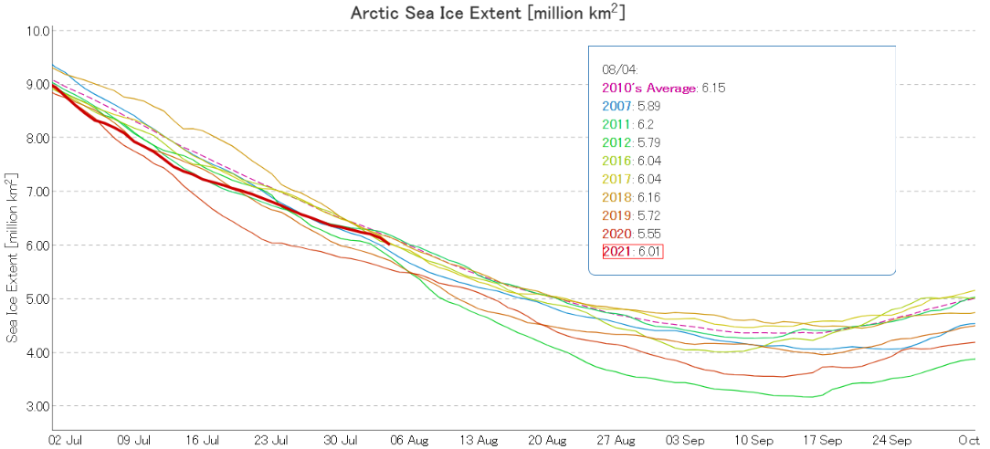
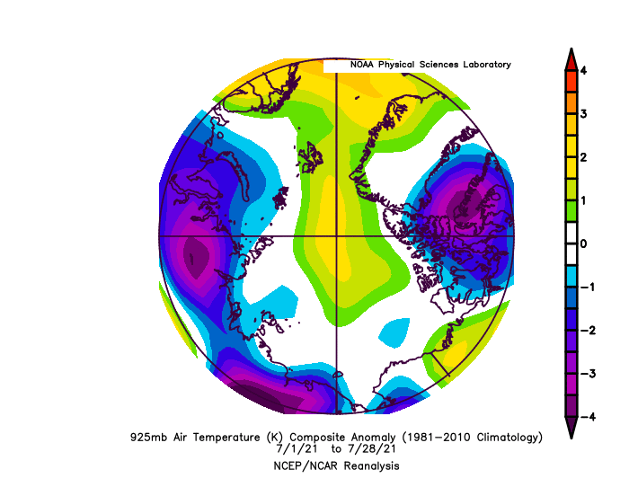
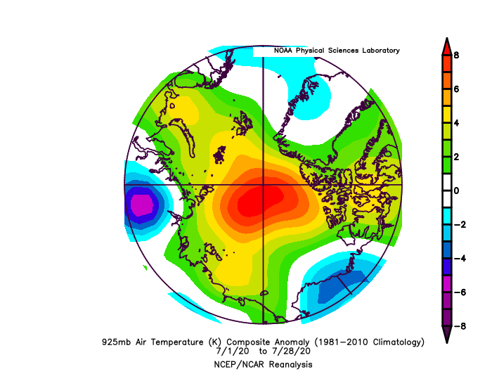
Let’s first of all take a look at JAXA’s flavour of Arctic sea ice extent:
After reaching lowest extent for the date in early July, the weather in the Arctic Basin was stormy, cloudy and cool compared to other recent years until the last few days of the month:
Here’s the same period in 2020 for comparison purposes:
Consequently the rate of extent loss in the second half of July was significantly less than last year.
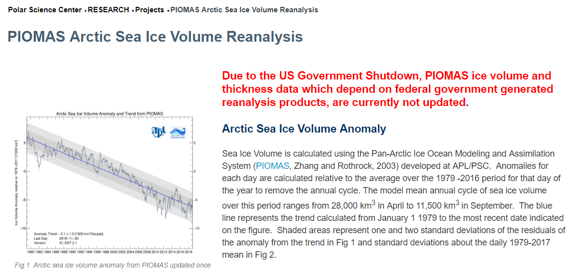
We generally write our periodic reports on the state of Arctic sea ice around the time the PIOMAS volume numbers are published. It seems as though we’ll have a long wait for that to happen at the moment though. According to The Economist today:
America’s government shutdown has become the longest in history. Hundreds of thousands of federal workers remain either stuck at home or forced to work without pay. To reopen the government President Donald Trump is demanding $5.7bn for his border wall. Nancy Pelosi, who presides over the most polarised House of Representatives in recent memory, does not want to give it to him.
Due to the US Government Shutdown, PIOMAS ice volume and thickness data which depend on federal government generated reanalysis products, are currently not updated.
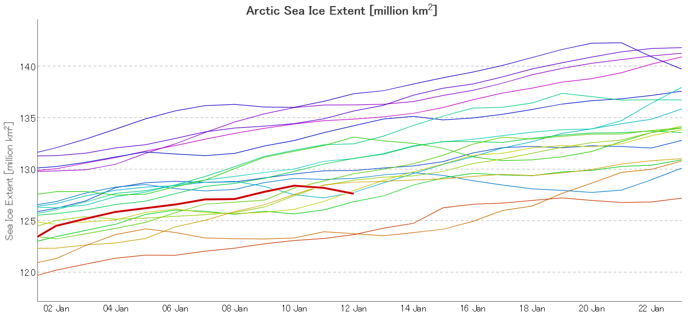
Instead of PIOMAS, let’s start instead with the January 2019 edition of the National Snow and Ice Data Center’s Arctic Sea Ice News:
As 2018 came to a close, Arctic sea ice extent was tracking at its third lowest level in the satellite record, while sea ice in the Antarctic remained at historic lows. Slightly faster growth in the first few days of the new year, mostly in the Pacific sea ice areas, has the daily sea ice extent at fifth lowest as of this post.
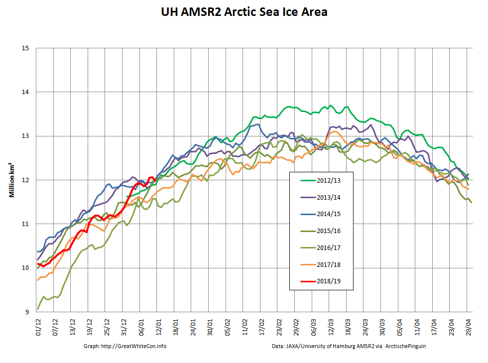
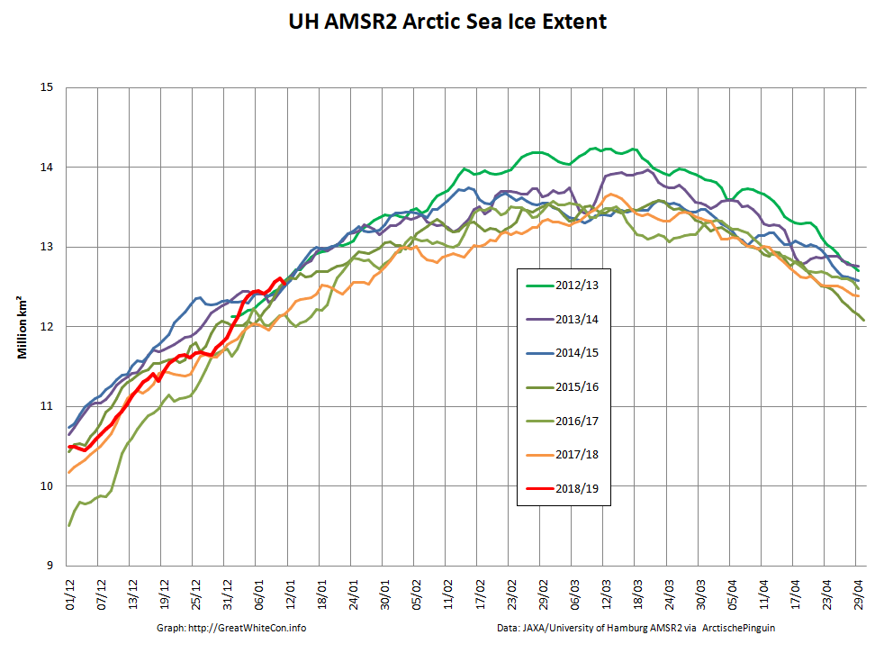
Now let’s take a look at our favourite high resolution AMSR2 area and extent metrics:
You can see that towards the end of December Arctic sea ice extent was verging on lowest for the date, since when it has risen quickly to reach highest for the date in the brief AMSR2 records a few days ago.
The NSIDC also mention the US Government shutdown:
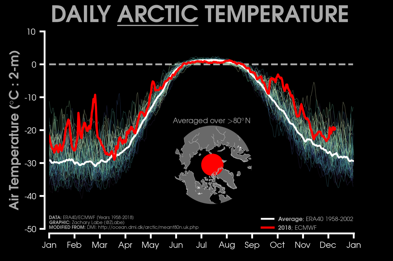
Unfortunately, as a result of the partial government shutdown, we are unable to access the National Oceanic and Atmospheric Administration (NOAA) pages to retrieve information on atmospheric air temperatures and sea level pressure patterns. Instead, we turn to daily (2 meters above the surface) mean air temperatures north of 80 degrees North from the European Centre for Medium-Range Weather Forecasts (ECMWF) operational model. This analysis shows that air temperatures remained above the 1958 to 2002 average for all of December.
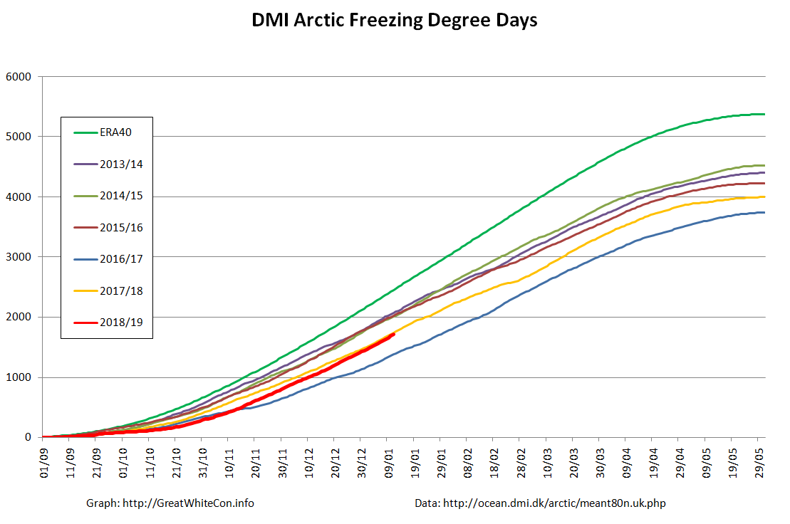
That brings us on to our Arctic freezing degree days graph, based on DMI data:
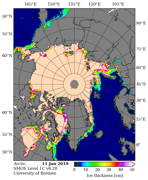
After a very slow start to the freezing season the FDD numbers are now vying for second place with last year, behind the astonishingly warm winter of 2016/17. In the absence of the PIOMAS volume numbers we can at least take a look at sea ice thickness. Here’s CryoSat-2:
All those sources seem to be agreed that large areas of both the Barents and Kara Seas are currently covered by young thin ice. Finally, for the moment at least, let’s take a look at some extracts from the NSIDC’s review of 2018:
January 2018 began the year with record low sea ice extents for the Arctic as a whole.
The seasonal maximum, reached on March 17, 2018, was the second lowest in the satellite record. While low extent persisted through April and May, sea ice loss during early summer was unremarkable despite above average 925 hPa air temperatures over the Arctic Ocean and Eurasia.
Air temperatures over the Arctic Ocean in July were below average, followed by above average temperatures in August. In fact, on average, August temperatures were higher than July temperatures in 2018. This is highly unusual in the Arctic and something not seen in at least 40 years.
The September 2018 seasonal minimum extent ended up slightly above the long-term linear trend line, tying with 2008 for the sixth lowest in the satellite record. After the minimum, the ocean was slow to freeze up, and October sea ice extent ended up as the third lowest. However, ice growth was very rapid in November, such that November 2018 extent approached the interquartile range of the 1981 to 2010 median. Nevertheless, large amounts of open water remained in the Barents and Chukchi Seas. By the end of December, ice conditions in the Chukchi Sea were back to average, while extent remained unusually low in the Barents Sea.
Coverage of old ice (greater than 4 years old) over the Arctic continued to decline. Such old ice covers only 5 percent of the area it used to in 1980s.
[Edit – January 13th]
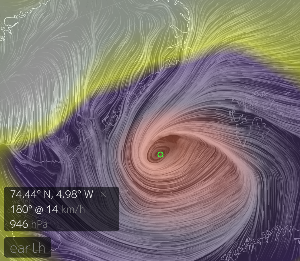
Arctic sea ice area and extent have both been falling over the last few days, possibly as a result of the recent cyclone which created strong northerly winds in the Fram Strait. This is from Earth at 09:00 UTC on January 10th, showing a MSLP of 946 hPa:
Here’s what used to be referred to as JAXA extent:
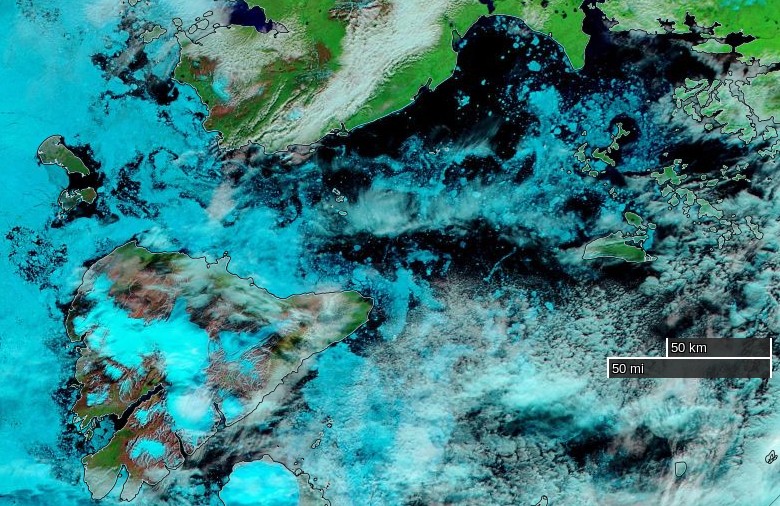
Depending on whether you’re reading an “alarmist” or a “skeptical” web site you may have been told either that the Northern Sea Route is already “open” or that the “icebreaker stuck in the sea ice off Pevek” escaped very late this summer. Here at Great White Con we like to think of ourselves as “realists”, so what are the actual facts of the matter.
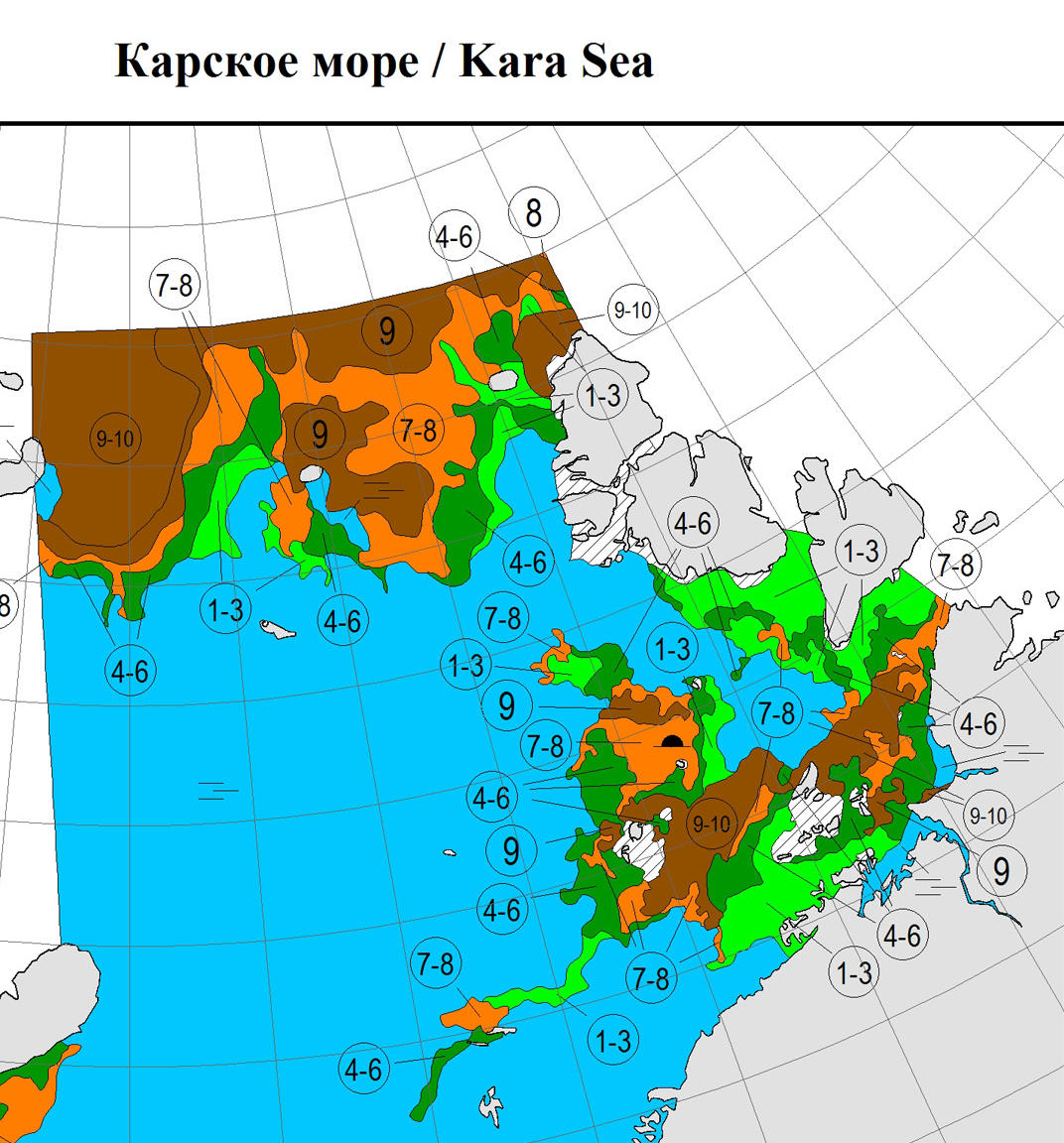
Our customary way of looking at such things is to use the Canadian Ice Service’s definition of “open” for the Northwest Passage, which seems to be 3/10 or less concentration along the entire route. That would allow an intrepid little yacht like Northabout through without too much trouble, but that point has not quite been reached yet this year. The NSR looks to be eminently “open” already if you only look at an AMSR2 concentration map:
However according to the Russian Arctic and Antarctic Research Institute (AARI for short) there is still not a suitably simple way through Vilkitsky Strait. Here’s their latest ice chart of the area:
Convoys led by nuclear powered icebreakers have already passed through the Vilkitsky Strait this summer. See for example this tracking map of Yamal from a few days ago:
Also an unaccompanied liquid natural gas carrier has made it through the Vilkitsky Strait already this year. According to a Total press release:
After loading its cargo at the Snøhvit LNG export terminal in Norway, in which Total has an 18.4% interest, the Christophe de Margerie is taking the Northern Sea Route to Boryeong in South Korea, where it will deliver a cargo for Total Gas & Power. It’s the first unescorted merchant LNG vessel ever to take this route, which makes it possible to reach Asia via the Bering Strait in 15 days versus 30 days via the Suez Canal.
This technological feat was made possible through the participation of Total teams to the design of these next-generation LNG carriers. Compilations of technology, they efficiently transport large quantities of LNG year-round, without requiring escort icebreakers during the period from July to November. The Christophe de Margerie is the first of a total of 15 planned LNG carriers that will be gradually deployed.
As you can see, whilst it travels forwards in open water the Christophe de Margerie goes into reverse when breaking ice! Little yachts and other unaccompanied vessels lacking an ice class certificate will have to wait just a little longer however, unless of course they are inclined to be “intrepid”.
[Edit – August 19th]
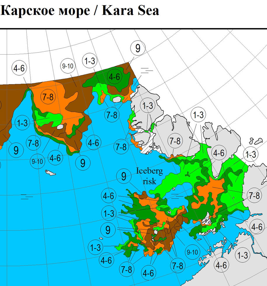
As Cesium points out below, there is now a <= 3/10 concentration channel through the Vilkitsky Strait on the AARI maps.
Here’s a couple of Sentinel 1A tiles from this morning stitched together:
We can now safely declare the Northern Sea Route “open”, even for less intrepid little yachts.
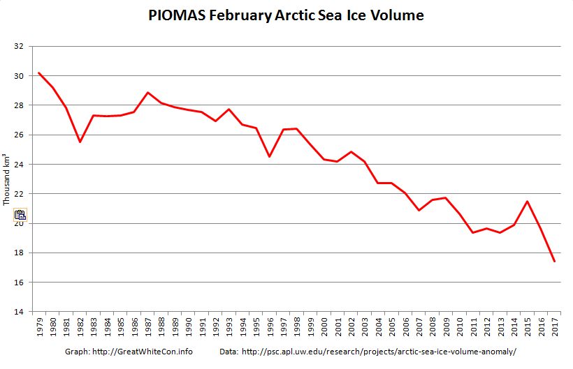
The February 2017 PIOMAS Arctic sea ice volume numbers are out. It’s no longer surprising to report that they are the lowest ever for the month of February in records going back to 1979:
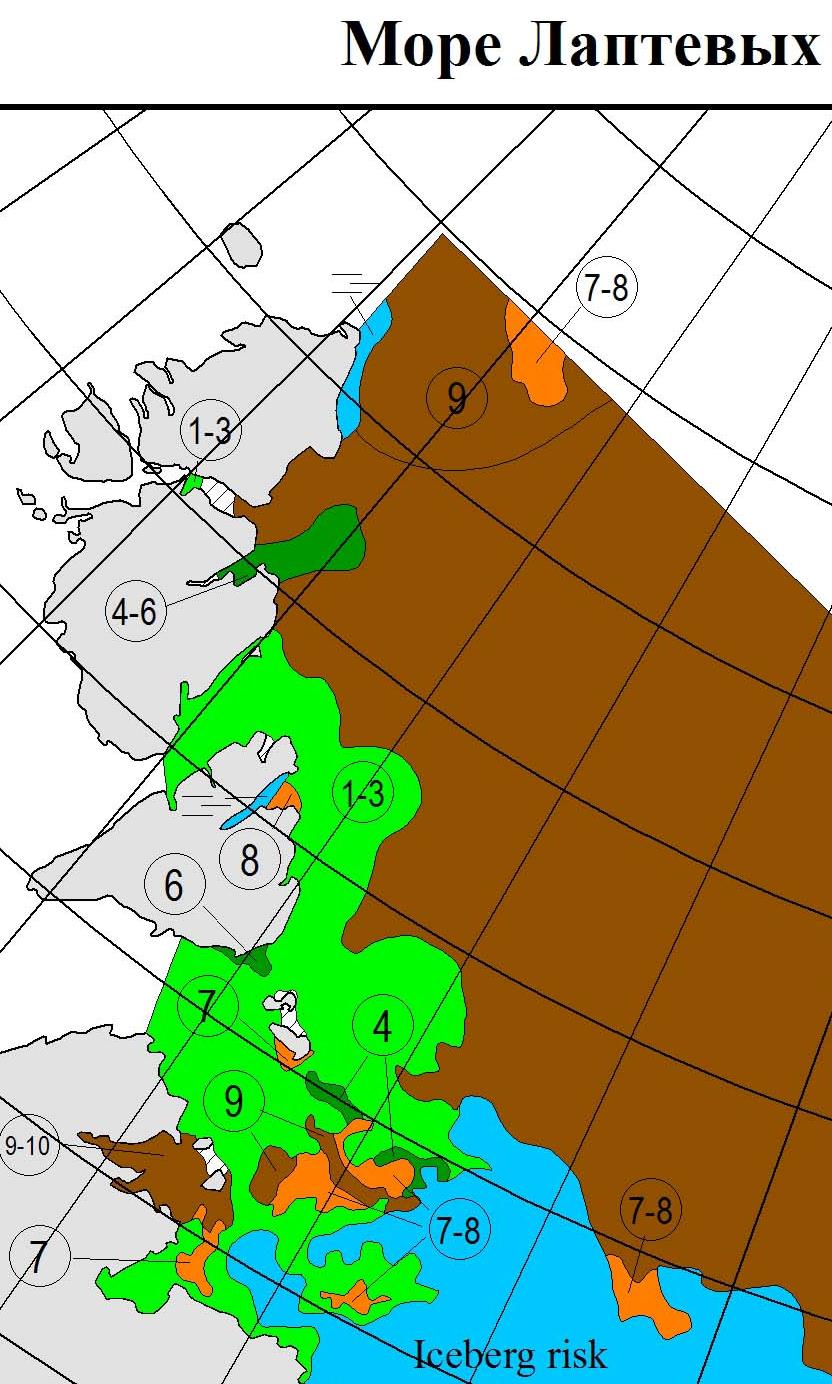
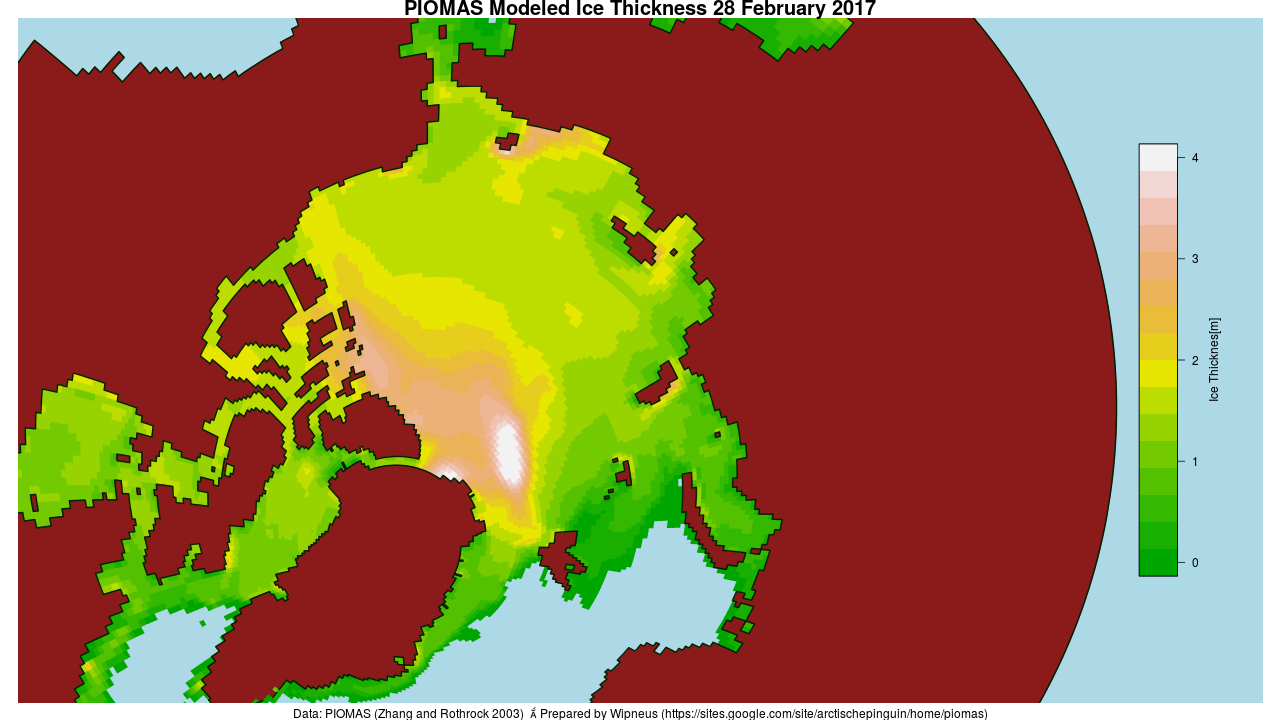
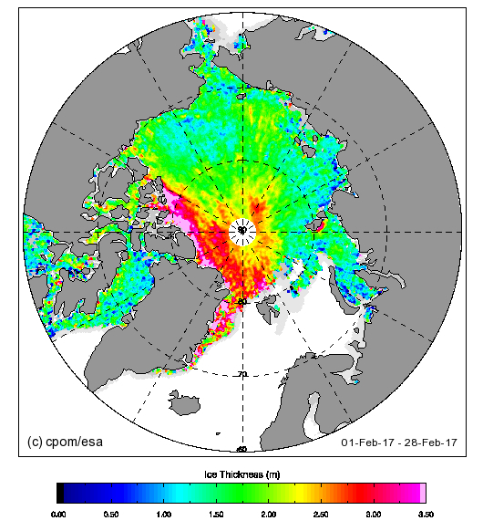
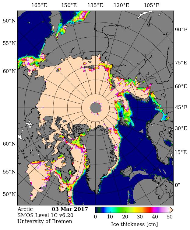
Here’s the PIOMAS gridded thickness map for February 28th:
There does seem to be a small patch of slightly thicker ice in the East Siberian Sea off Chaunskaya Bay, but there’s still a much larger area of sub 0.5 meter thick ice in the Laptev and Kara Seas.
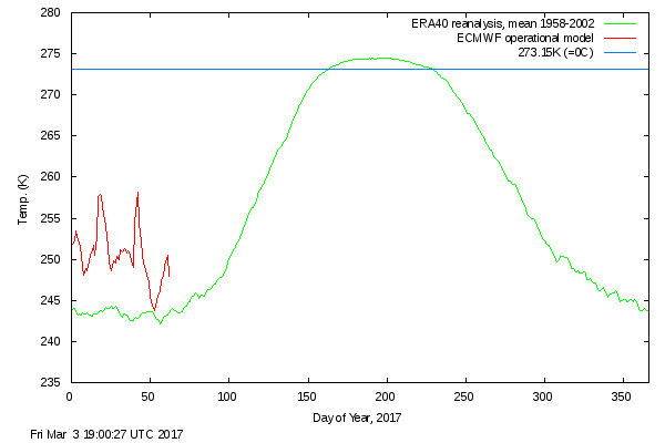
The Danish Meteorological Institute’s temperatures for the “Arctic area north of the 80th northern parallel” graph shows somewhat more “normal” readings in February 2017, but still without falling below the ERA40 climatology this year or in 2016:
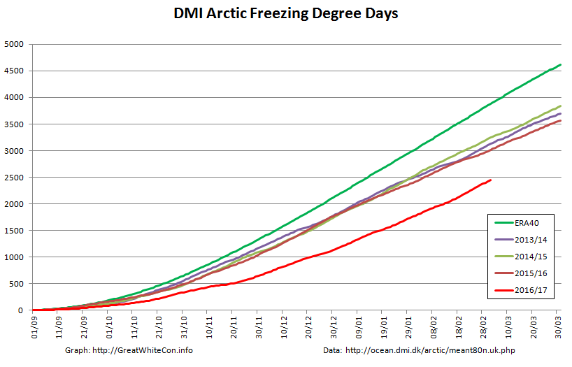
The graph of cumulative Freezing Degree Days (FDD for short) is still far below all previous years in DMI’s records going back to 1958:
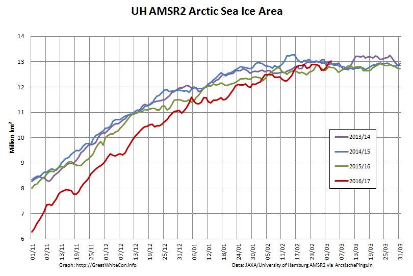
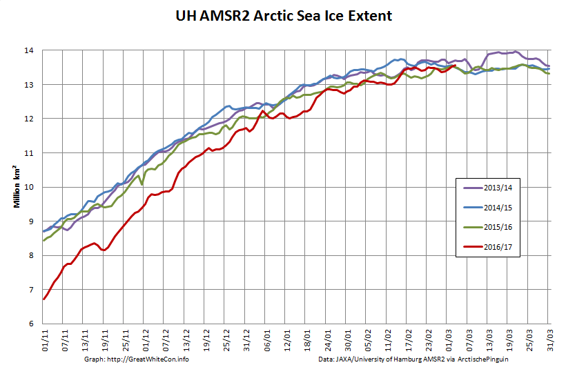
Finally, for the moment at least, here’s the high resolution AMSR2 Arctic sea ice area and extent:
I’m going to have to eat some humble pie, or crow pie as I gather it’s usually referred to across the Atlantic, following my tentative “2017 maximum prediction” a couple of weeks ago. Both area and extent posted new highs for the year yesterday, with area creeping above 13 million square kilometers for the first time this year.
[Edit – March 7th]
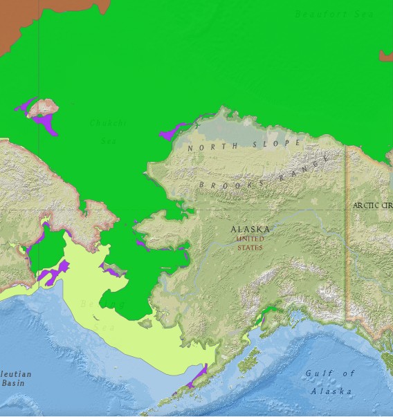
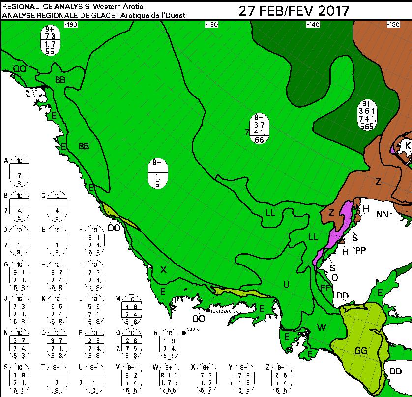
Commenter Michael Olsen suggests that “thicker ice being pushed into the Alaskan and Russian parts of the Arctic Ocean”. Here’s some evidence:
The United States’ National Weather Service current sea ice stage of development map for Alaskan waters:
This week’s Canadian Ice Service sea ice stage of development map is expected later today, so for now here’s last week’s:
Especially for Michael, a visual image of all the “thicker ice [that’s been] pushed into the Russian parts of the Arctic Ocean” courtesy of the nice folks at NASA:
NASA Worldview “true-color” image of the Chukchi Sea on March 10th 2017, derived from the MODIS sensor on the Aqua satellite
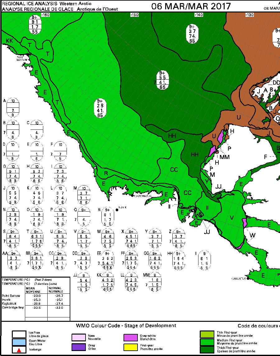
[Edit – March 12th]
Yet another strong Arctic cyclone has been battering the sea ice in the Arctic Basin. According to Environment Canada this one bottomed out at 971 hPa at 06:00 UTC today.
I recently found myself in an extended discussion on Professor Judith Curry’s “Climate Etc.” blog with Tony Brown. Tony asserts that:
In 1932, a Soviet expedition led by Professor Otto Yulievich Schmidt was the first to sail all the way from Arkhangelsk to the Bering Strait in the same summer without wintering en route. After a couple more trial runs, in 1933 and 1934, the Northern Sea Route was officially defined and open and commercial exploitation began in 1935. The next year, part of the Baltic Fleet made the passage to the Pacific where armed conflict with Japan was looming.
and asks:
Are you SERIOUSLY suggesting that the northern sea route was not operable from the 1930’s onwards?
My response?
I’m still awaiting your pick of the year in the 1930s in which the NSR was most “open”. I have a sneaking suspicion it won’t conform to, for example, the current Canadian Ice Service definition.
I won’t bore you with the long list of questions I asked Tony that he has thus far failed to answer. Instead let’s take a closer look at the history of the Northern Sea Route than Tony is willing and/or able to undertake. Perhaps the most obvious place to start is the “History of the Northern Sea Route“? However this does rather gloss over the 1930s. For our initial reference let’s see what Bill Barr has to say in his “The Drift of Lenin’s Convoy in the Laptev Sea, 1937 – 1938″, published in 1980.
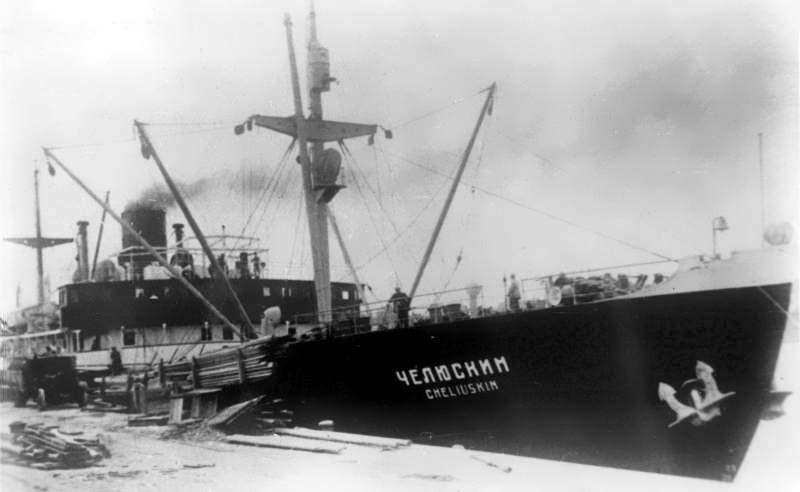
Only a few months after Sibiryukov‘s limited success in her attempt at a one-season passage of the Northern Sea Route, so eloquently embodied in her final emergence from the ice of the Chukchi Sea under improvised sails, on December 17, 1932 Sovnurkom (the Soviet of Peoples’ Commissars) took the momentous step of forming the Chief Administration of the Northern Sea Route (Gluvnoye Upruvleniye Severnogo Morskogo Puli), more commonly known as Gluvsevmorput’. Its primary task was to establish safe, reliable navigation from the White Sea to Bering Strait, but in a series of subsequent decrees over the next few years it also acquired a remarkable array of ancillary functions, and along with them, remarkably wide powers. In effect Gluvsevmorput’ was given almost complete control of the entire vast area of Siberia north of 62″ (the latitude of Yakutsk) not only in terms of transport and economic development, but also education, health services and cultural development. Even with these extensive powers, however, the new organization’s first attempt at demonstrating that it was capable of tackling its primary task was a disastrous failure. In her attempt at making a one-season passage of the Northern Sea Route in the summer of 1933 the steamer Chelyuskin became beset in the ice of the Chukchi Sea, and after drifting helplessly for several months, was ultimately crushed and sank on February 13, 1934. However, the new organization’s reputation was definitely redeemed the following year when the icebreaker Fyodor Litke reached Murmansk on September 20, 1934, having succeeded where Chelyuskin had so utterly failed.
To summarise, one of Tony’s “trial runs in 1933” was “a disastrous failure”!
On 1 October 1932 the icebreaking steamer Sibiryukov emerged from the ice in Bering Strait having completed the first one-season passage of the Northern Sea Route from Arkhangelsk. It was not an unqualified success, however; Sibiryakov had lost her propeller two weeks previously and had managed to reach the edge of the ice only under improvised sails and with a large measure of luck.
Moving on to another 1933 “trial run” Bill informs us that:
In 1933 the newly-formed Gluvsevmorput’ dispatched the first convoy of freighters via the Northern Sea Route to the mouth of the Lena to deliver cargoes bound for the Yakut ASSR. It consisted of three freighters and was escorted by the icebreaker Krasin. Despite heavy ice conditions in the Kara Sea two of the ships reached Tiksi, their destination, and unloaded their cargoes. The third ship, bound for Bukhta Nordvik with an oil exploration expedition, ran aground near its destination and turned back. Severe ice conditions in Proliv Vil’kitskogo forced all three ships to winter at the Ostrova Samuila. A shore station was built and a full scientific programme maintained all winter. Urvantsev, the chief scientist, took the opportunity to make a winter reconnaissance survey of the northern portion of Poluostrov Taymyr using half-tracks. The convoy was freed from the ice by the icebreaker Fyodor Litke in the summer of 1934 and having completed their tasks all three ships ultimately returned safely to Arkhangel’sk.
Not exactly an unqualified success either then, and certainly not a single season transit of the full Northern Sea Route! However despite all her assorted trials and tribulations the icebreaker Fyodor Litke did manage to complete a single season transit from Vladivostok to Murmansk, and according to Wikipedia “became a Soviet propaganda icon”.
Returning to Barr 1980, we discover that:
In the summer of 1935 Fyodor Litke escorted the first two laden freighters, Vantsetti and Iskra, through the Sea Route from west to east; sailing from Leningrad on July 8, they reached Vladivostok on October 8. Meanwhile two other steamers, Anadyr’ and Stalingrad, made the through-passage in the opposite direction, sailing from Vladivostok on July 23 and 25 and reaching Leningrad on October 16.
The following season (1936) saw a spectacular increase in activity along the Northern Sea Route; a total of 160 ships travelled parts of the route (the bulk of them from the west to the mouth of the Yenisey and back), while 16 vessels made the through-passage, 14 from west to east, and 2 from east to west, the latter being Vantsetti and Iskra homeward bound to Leningrad. The ships heading east included the first Soviet warships to utilize the Northern Sea Route, the destroyers Voykov and Stalin, escorted once again by Fyodor Litke
Hence 1935 and 1936 were far more successful years than the previous two, but then we come to 1937. Quoting Barr 1980 once again:
The plans for the 1937 season were equally ambitious, but by then the run of luck had ended. Due to a combination of abnormally severe ice conditions and some very unfortunate decisions as to routing of convoys and deployment of icebreakers towards the end of the season, 25 ships were obliged to winter on an emergency basis at various points in the Soviet Arctic. Perhaps the most critical aspect, however, was that of Gluvsevmorput’s fleet of icebreakers; only one, the veteran Yermak was not forced to winter in the Arctic.
One of the other questions I asked Tony Brown over at Prof. Judy’s was:
It would be helpful if you selected an ice chart from the 1930s to illustrate your point.
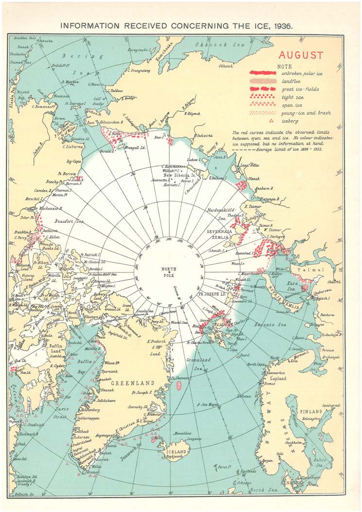
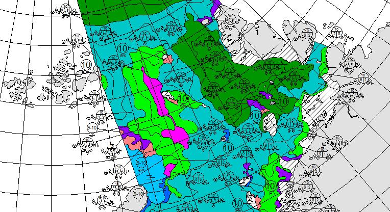
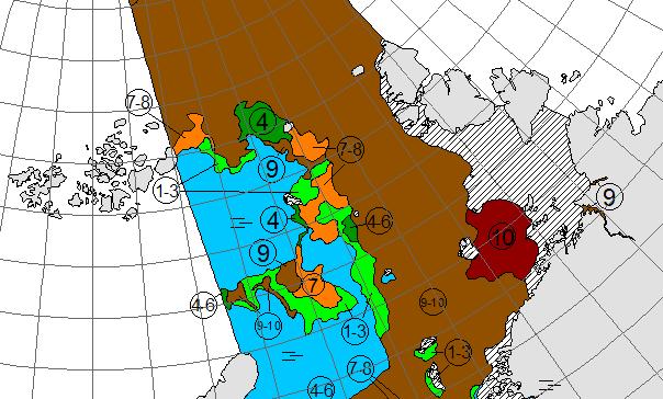
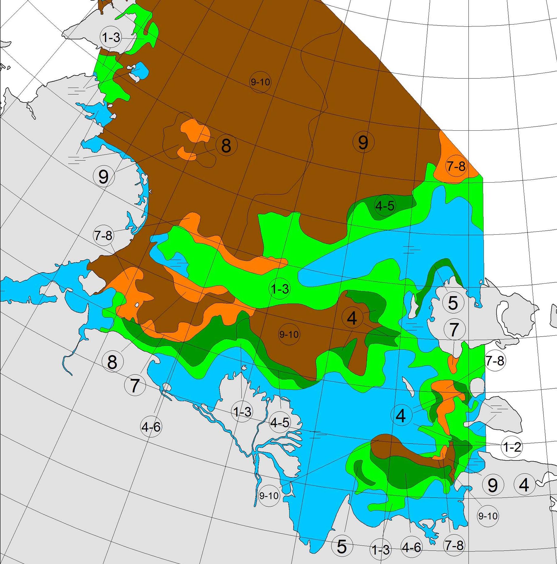
Tony still hasn’t got around to doing that, so why don’t we take a look at the August 1936 chart from the archives of the Danish Meteorological Institute:
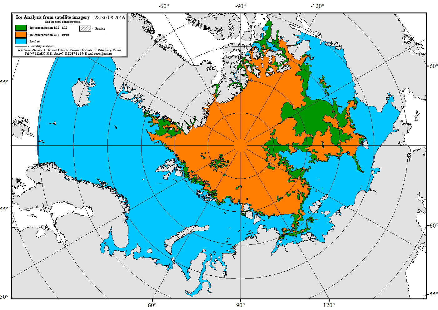
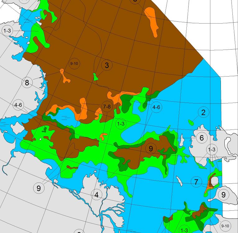
It certainly doesn’t look to me as though the entire Northern Sea Route was covered by no more than 3/10 concentration sea ice in August 1936. For comparison purposes here’s the Russian Arctic and Antarctic Research Institute ice chart for the end of August 2016:
For an eyewitness account of conditions along the Northern Sea Route in 2016 see our series of articles on the voyage of the yacht Northabout
I had an interesting watch this morning. Just crawled out of bed, rocking and rolling getting ready. I even put my second thermals on, checked the log to see what was happening. clipped on before leaving the saloon, and clipped on behind the wheel.
Just sitting down, put my leg up for stability and a wave came across the boat. Didn’t see it or hear it. For a fraction of a second, my whole body was under water, and it was only my leg stopping me going out of the side, and hopefully my tether would have stopped me going over completely.
I actually had a mouth full of sea water which was novel. Nikolai thought it was hilarious. I’m just very pleased it was me and not one of the lighter ladies.
Here’s brief video showing some slightly smaller waves:
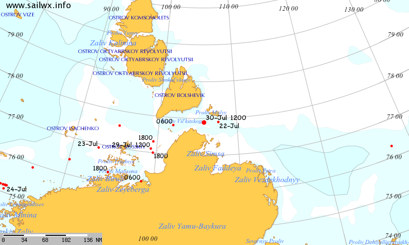
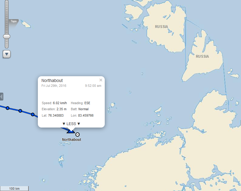
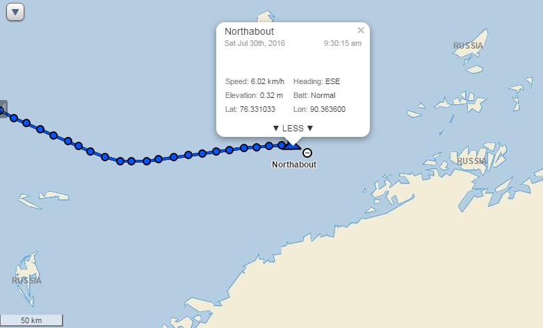
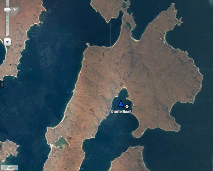
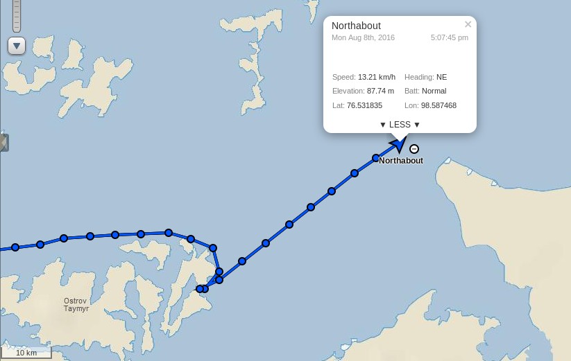
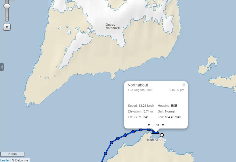
Their live tracking map reveals that they have passed Ostrov Troynoy and are now heading east in the general direction of the Nordenskiöld Archipelago:
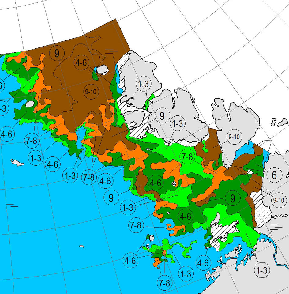
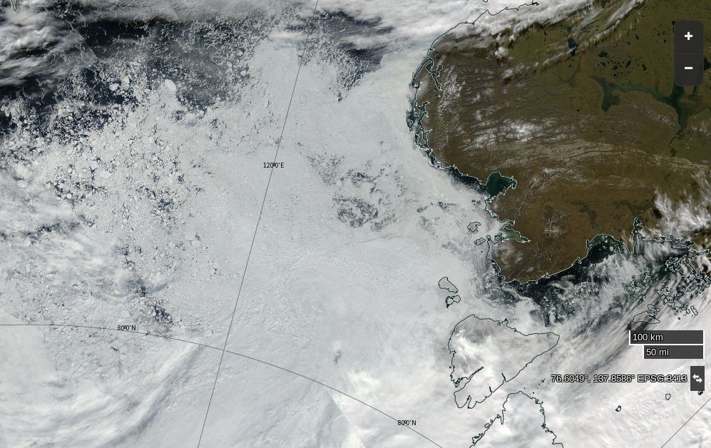
The latest sea ice map of the north eastern Kara Sea reveals some open water in the Vilkitsky Strait, but as yet no way through for a small yacht like Northabout:
A bit further afield the University of Hamburg’s AMSR2 imagery reveals the current ice conditions along the rest of the Northern Sea Route:
All in all it doesn’t look as though Northabout’s crew will beaming videos back to us from the Laptev Sea over the next few days, but never say “never” in the Arctic!
N76 20 E083 28 Pressure 998 water temp 4 outside temp 5 cloud 6/8 sea state 3 winds 15 knots.
Making steady progress east. I always love it when we click over degree of longitude. Of course, they are pretty close together up here. ( I have been dreaming of the 180 long), for weeks.
The winds will slowly take us north east today and tomorrow. Hopefully find our island with the Palm trees and wait for the Ice to break up. Looking forward to seeing an Ice update today and see if this storm has changed anything. Fingers crossed.
The Vilkitsky Strait is covered in thick clouds this morning, so here once again is the view from on high using passive microwaves:
Today’s sea ice update is that concentration in the Nordenskiöld Archipelago and Vilkitsky Strait seems to be falling fast. Visual confirmation of that is eagerly awaited.
Making steady progress East. We had the latest ice charts for the Vilkitskogo straight. Still blocked and the Laptev still blocked, but big changes from the last set of charts, and encouraging.
Nikolai and Dennis are having bets. Nikolai thinks it will be free on his birthday, the 9th Aug, and Dennis on his, 6th Aug . Either way, would mean a few days rest. We are heading for a small sheltered Island. Different to the first choice, as the ice from the North has come down and blocked it, so trying for another Island closer to shore and closer to the straight. So if anything dramatic changed quickly, we would be close to react. Ie, A strong southerly taking the ice from the shore.
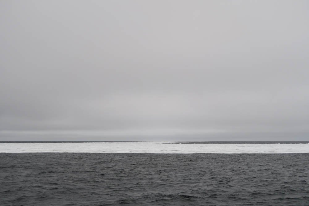
Saw our first ICE today on my watch, just an hour ago. What is slightly worrying, it didn’t show up on the Radar. It’s probably good for the big icebergs, but not low ice in the water. I think we will see a lot more of that before the trip is out. You can’t beat that old eyeball.
[Edit – July 31st]
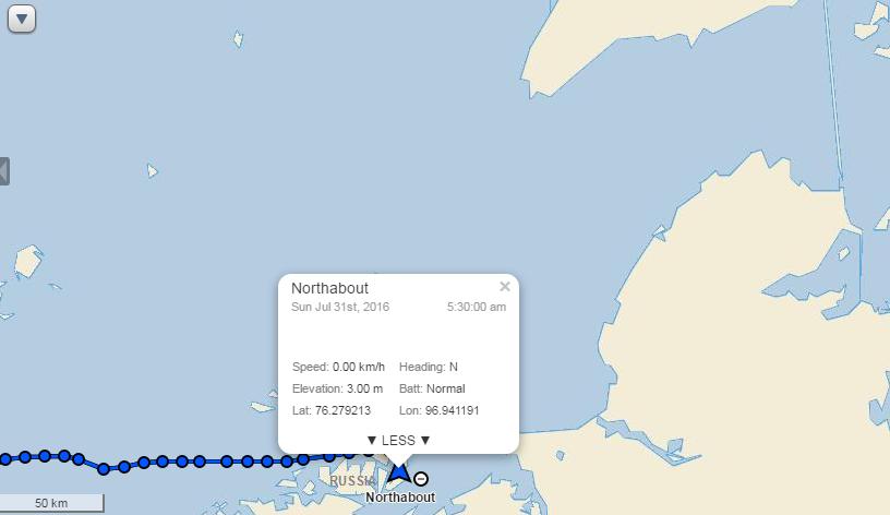
In a brief update this morning the crew of Northabout report they are:
Anchored! for rest repairs and to wait for favourable ice conditions in the NE passage and for the new ice charts. Proper shipslog update coming later with some photos (which take ages to upload) But for now we’re getting a bit of a rest & having a cuppa.
They have found some shelter in the convoluted coastline of Ostrov Pilota Makhotkina, just off the shores of Siberia and within striking distance of their exit from the Kara Sea:
As Reggie points out below, the sea ice in the Vilkitsky Strait broke up remarkably early this year. Here’s his view from June 23rd:
NASA Worldview “false-color” image of the Vilkitsky Strait on June 23rd 2016, derived from the VIIRS sensor on the Suomi satellite
and if you watch our latest Northern Sea Route animation carefully you’ll note that the ice was already mobile at the beginning of June:
In actual fact the Vilkitsky Strait never became blocked with land-fast ice last winter. Compare this ice chart from the Russian Arctic and Antarctic Research Institute for May 4th 2016:
Three years ago the island where Northabout is now sheltering was still encased in land fast ice at the beginning of July, as was the Vilkitsky Strait itself. By August 25th when the yacht Tara passed around Cape Chelyuskin into the Laptev Sea on her own Polar circumnavigation the Strait looked like this:
[Edit – August 1st]
The latest video from the crew of Northabout reveals them anchoring off Ostrov Pilota Makhotkina:
The skies have cleared over the Vilkitsky Strait this morning! Here’s a “false colour” image from the MODIS instrument aboard the Aqua satellite:
NASA Worldview “false-color” image of the Vilkitsky Strait on August 1st 2016, derived from the MODIS sensor on the Aqua satellite
On “true colour” images sea ice looks white, and so do clouds. Using a different set of wavelengths reveals the ice in pale blue, with the clouds still white. Northabout remains anchored, and it’s easy to see why!
[Edit – August 2nd]
The latest AARI ice charts are out, but don’t reveal a way through to the Laptev Sea for Northabout just yet:
Here’s a fairly cloud free satellite image of what lies ahead:
NASA Worldview “true-color” image of the Laptev Sea on August 2nd 2016, derived from the MODIS sensor on the Aqua satellite
The crew of Northabout report that some of that ice has made its way into their anchorage:
Whilst at anchor we have a respite from our normal watch routine and it is replaced with Anchor Watch, which is an hour and half slot, mine is from 12.30am to 2am. The other crew and Northabout are in a deep slumber, perfect quiet interspersed with gentle snoring from contented crew! Last night was an exception, as the wind picked up and changed direction, resulting in some bits of drifting ice coming into the bay, ‘crashing’ into the boat at about 4am, giving all the crew an alarming wake up call. There was no danger, it was simply the deafening noise of ice and aluminium in the still of the night! Dennis was soon on the job with the ice poles, keeping all at bay!
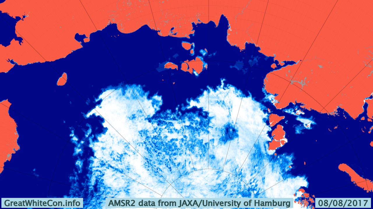
[Edit – August 8th]
As Bill points out below, Northabout is now heading in the direction of Vilkitsky Strait:
Perhaps they’ve had an early look at the latest AARI ice charts of the Laptev Sea? The Northern Sea Route Administration web site is still displaying the ones from August 5th, which showed the route blocked by 9/10 ice coverage in places:
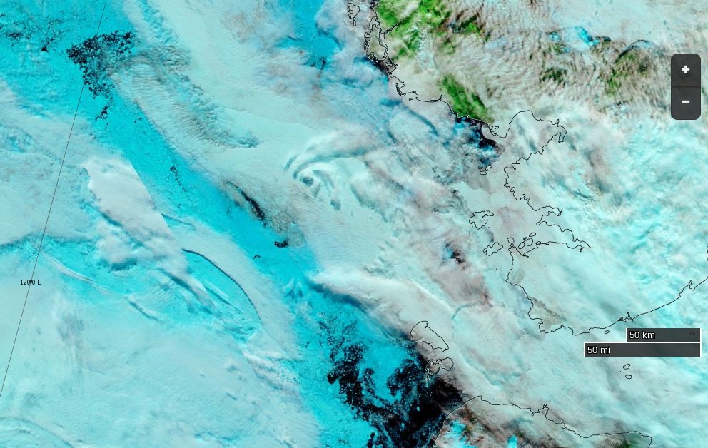
Satellite imagery at visual frequencies is rather cloudy again today:
NASA Worldview “false-color” image of the Laptev Sea on August 8th 2016, derived from the VIIRS sensor on the Suomi satellite
but there’s still no obvious way through to the East Siberian Sea that I can see.
[Edit – August 9th]
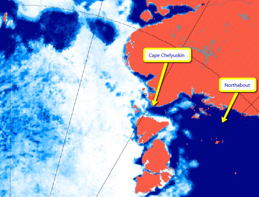
Northabout has just rounded Cape Chelyuskin and is now heading into the Laptev Sea!
Here’s the new ice chart for the Laptev Sea:
A navigable strip does seem to be opening up around the coast, but there’s still a stubborn patch of 9/10 concentration sea ice blocking Northabout’s way.
This website uses cookies to improve your experience. We'll assume you're ok with this, but you can opt-out if you wish. Cookie settingsACCEPT
Privacy & Cookies Policy
Privacy Overview
This website uses cookies to improve your experience while you navigate through the website. Out of these, the cookies that are categorized as necessary are stored on your browser as they are essential for the working of basic functionalities of the website. We also use third-party cookies that help us analyze and understand how you use this website. These cookies will be stored in your browser only with your consent. You also have the option to opt-out of these cookies. But opting out of some of these cookies may affect your browsing experience.
Necessary cookies are absolutely essential for the website to function properly. This category only includes cookies that ensures basic functionalities and security features of the website. These cookies do not store any personal information.
Any cookies that may not be particularly necessary for the website to function and is used specifically to collect user personal data via analytics, ads, other embedded contents are termed as non-necessary cookies. It is mandatory to procure user consent prior to running these cookies on your website.