Prompted by a comment on the Northwest Passage thread from last year I’m opening the 2021 equivalent earlier than usual, in part because there’s already a lot going on of interest. First of all let’s get our bearings with the help of this map of the area:

and another map detailing the routes through Canadian Arctic Archipelago that have previously been successfully traversed:

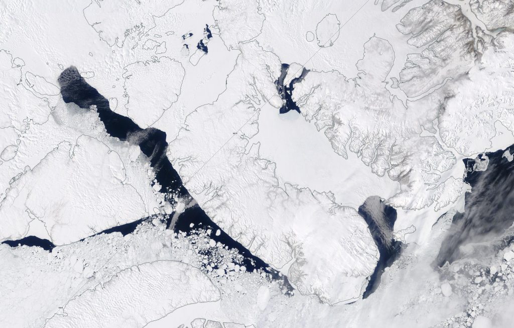
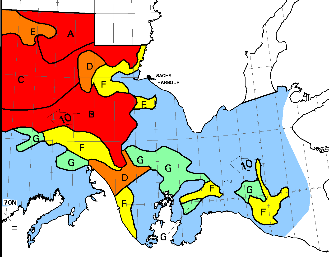
The forecast high pressure has arrived and the skies have cleared over the Beaufort Sea, which reveals that the land-fast ice off the Mackenzie Delta has started breaking up:
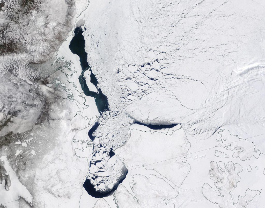
In addition the snow has been melting along the valley of the Mackenzie River, and the resulting increased flow at the mouth of the delta is flooding the fast ice:
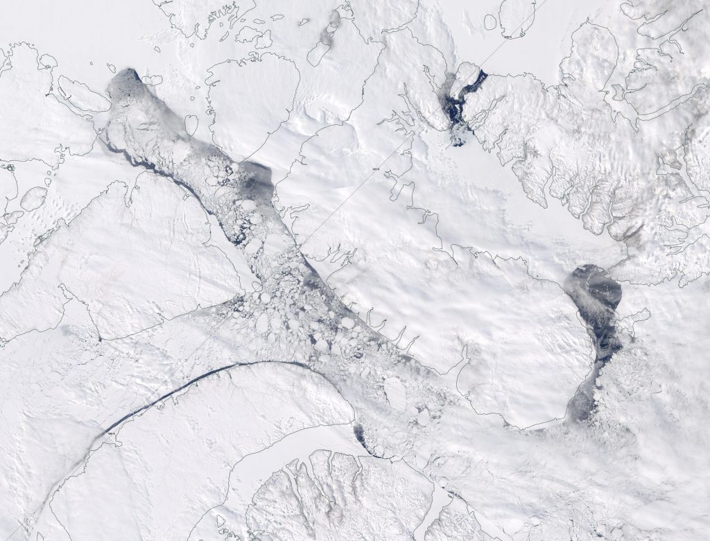
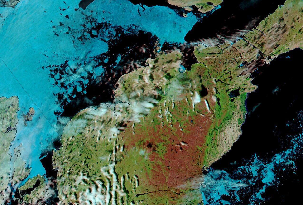
Further east Barrow Strait and Lancaster Sound are also crumbling:
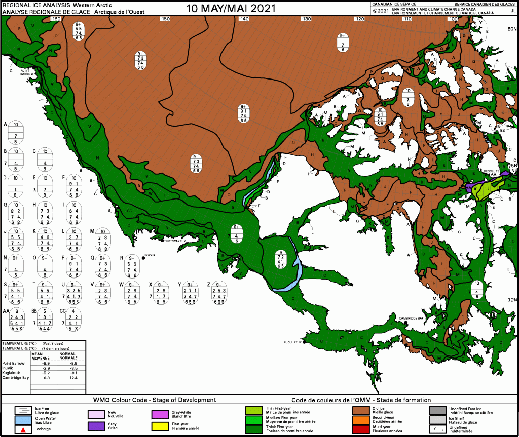
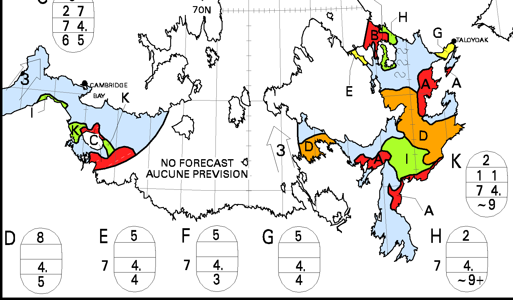
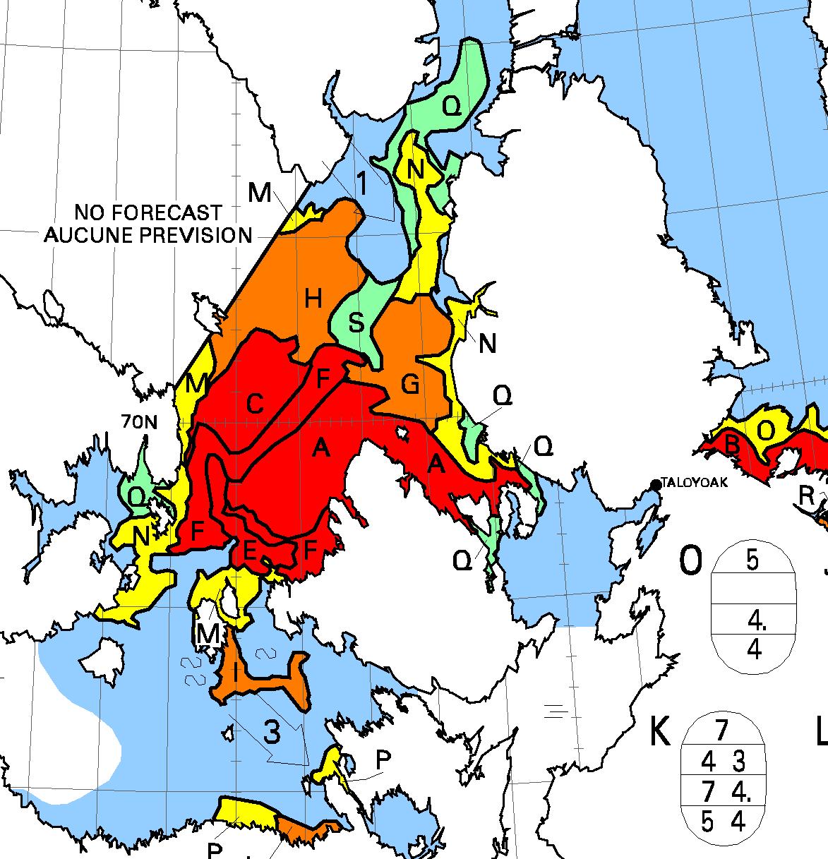
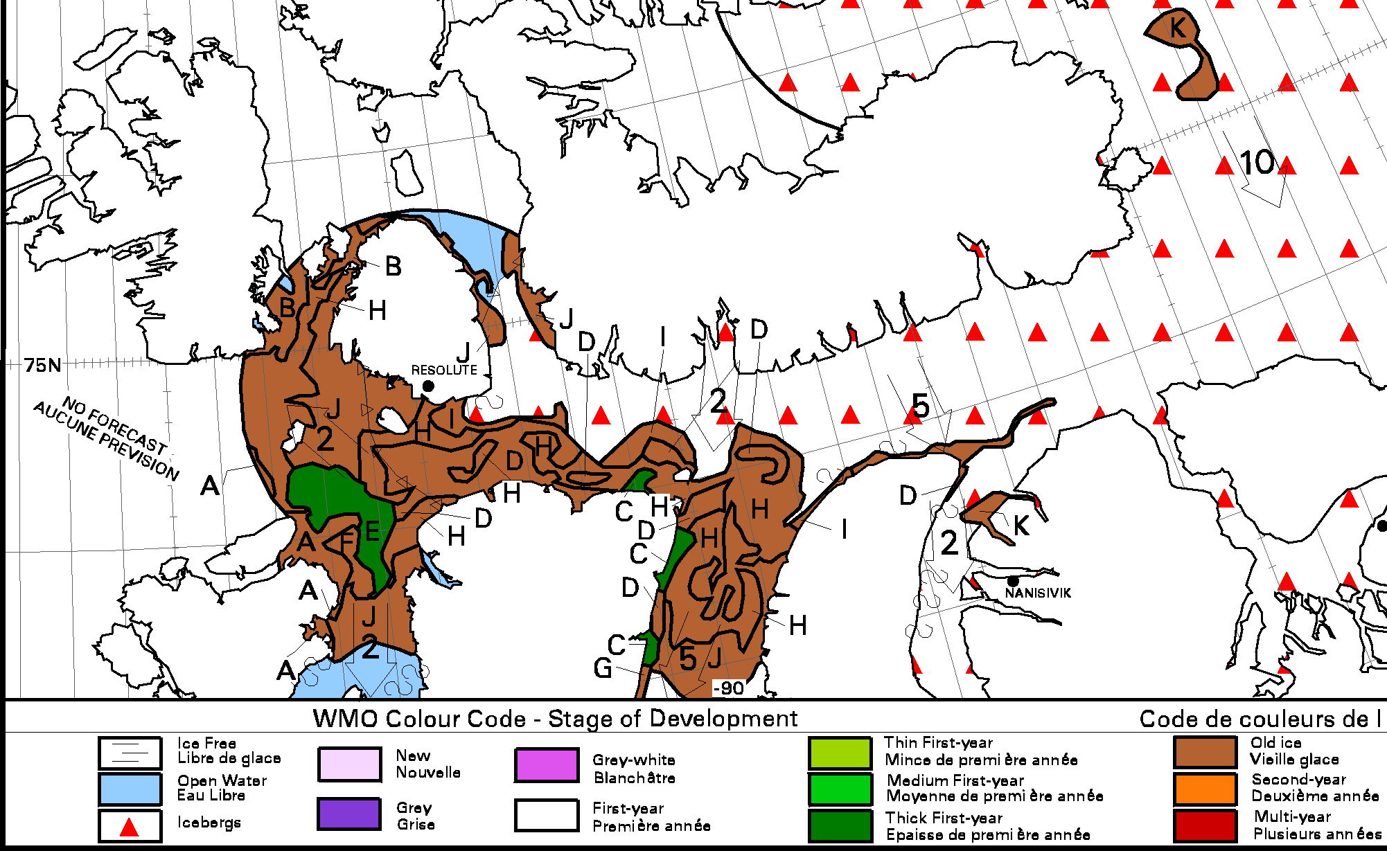
But what about the sea ice in the Canadian Arctic Archipelago that isn’t already falling apart at the seams? To get a feel for what might happen during the coming melting season let’s take a look at the Canadian Ice Service‘s “stage of development” charts. Here’s the most recent one, from May 10th:
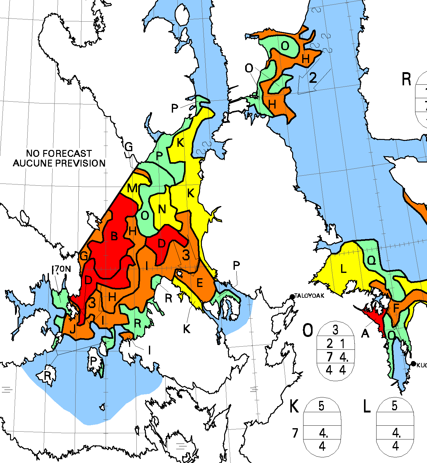
Several of the assorted routes along the Northwest Passage are currently clear of multi-year ice, so let’s also try and check the thickness of the ice along those routes. Here is the latest available merged CryoSat-2/SMOS thickness map for the Canadian Arctic Archipelago :
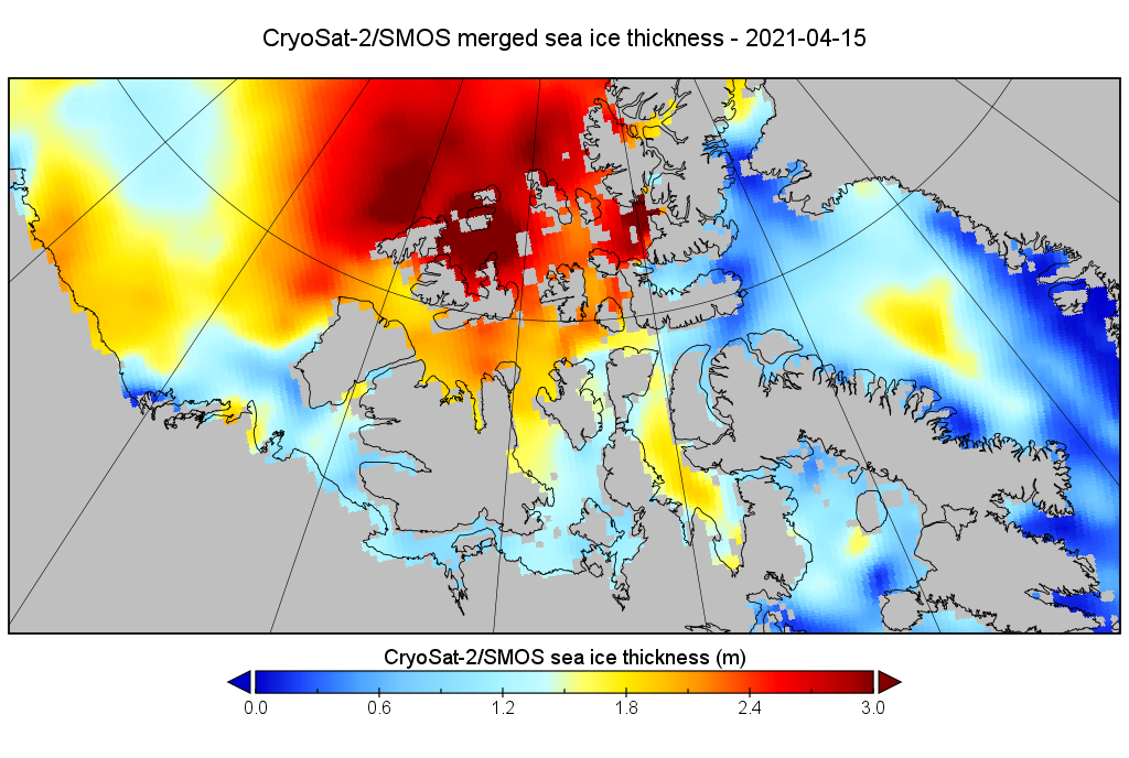
All in all it looks to me as though the Northwest Passage will open earlier than “normal” this year, but as always everything depends on the summer weather.
[Edit – May 28th]The skies were clear over the Canadian Arctic Archipelago yesterday, which revealed several patches of open water across the CAA and a long stretch of Route 1 already “open for business”:
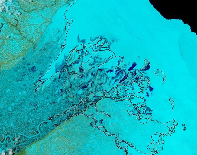
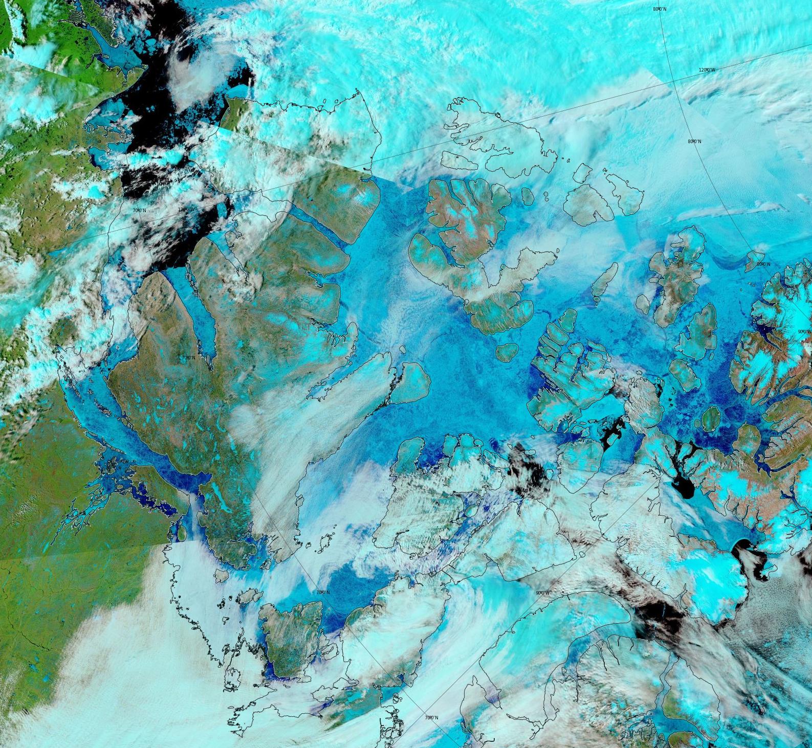
Melt ponds are currently visible across most of the Canadian Arctic Archipelago:
As a consequence sea ice area in the Canadian Arctic Archipelago is now the lowest for the date in the nearly 10 year AMSR2 record:
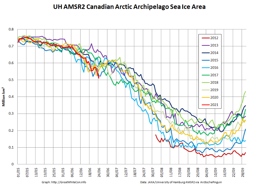
AMSR2 concentration data for 2012 doesn’t begin until August, so it’s conceivable that area on June 25th 2012 was lower than this year.
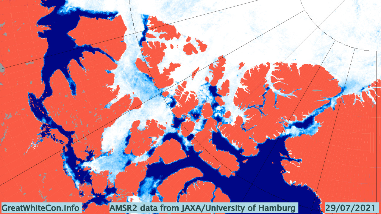
[Edit – July 30th]Here’s AMSR2’s current overview of the Canadian Arctic Archipelago:
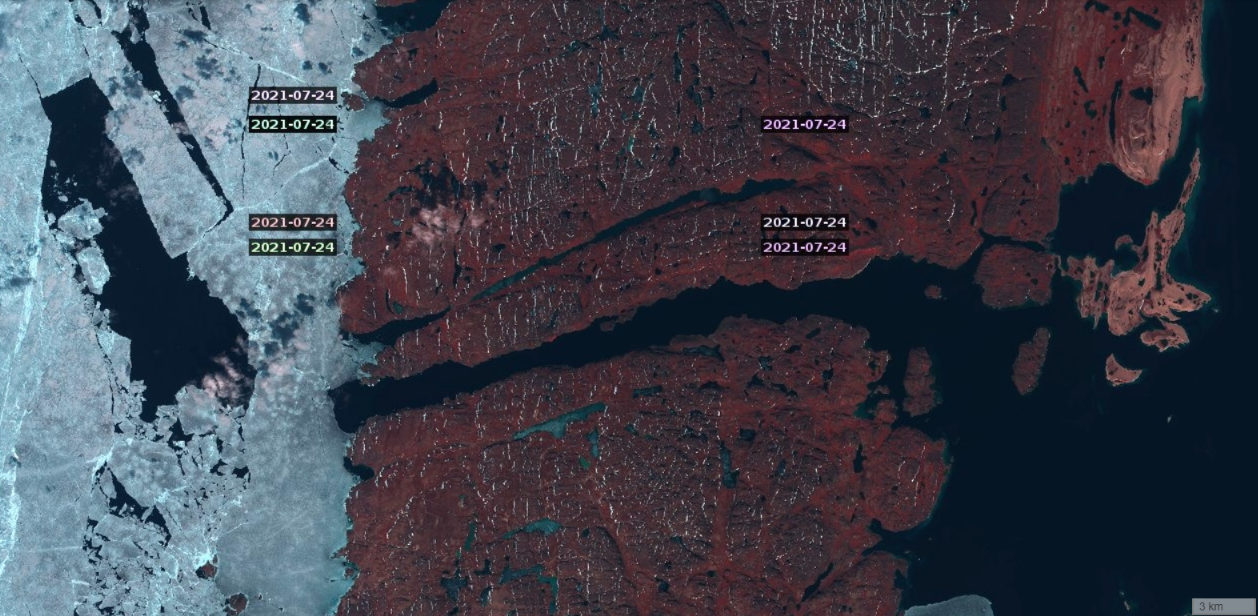
The route from Baffin Bay as far as the eastern entrance of Bellot Strait looks to be navigable, but what about the Strait itself? Sentinel 2 reveals that the way is clear as far as the western entrance:
The Canadian Ice Service has started coverage of the Queen Maud Gulf area, which currently looks like this:
It looks to me as though route 6 will be the first to open, in a couple of weeks or so. However depending upon winds and weather that could quickly change.
[Edit – August 5th]The CIS haven’t extended their coverage to the Franklin Strait yet, but MODIS suggests that it’s now almost possible to squeeze along the coast to Gjoa Haven and beyond:
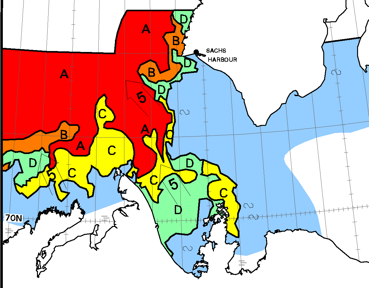
On the other hand getting past Cape Bathurst is becoming a trifle tricky:
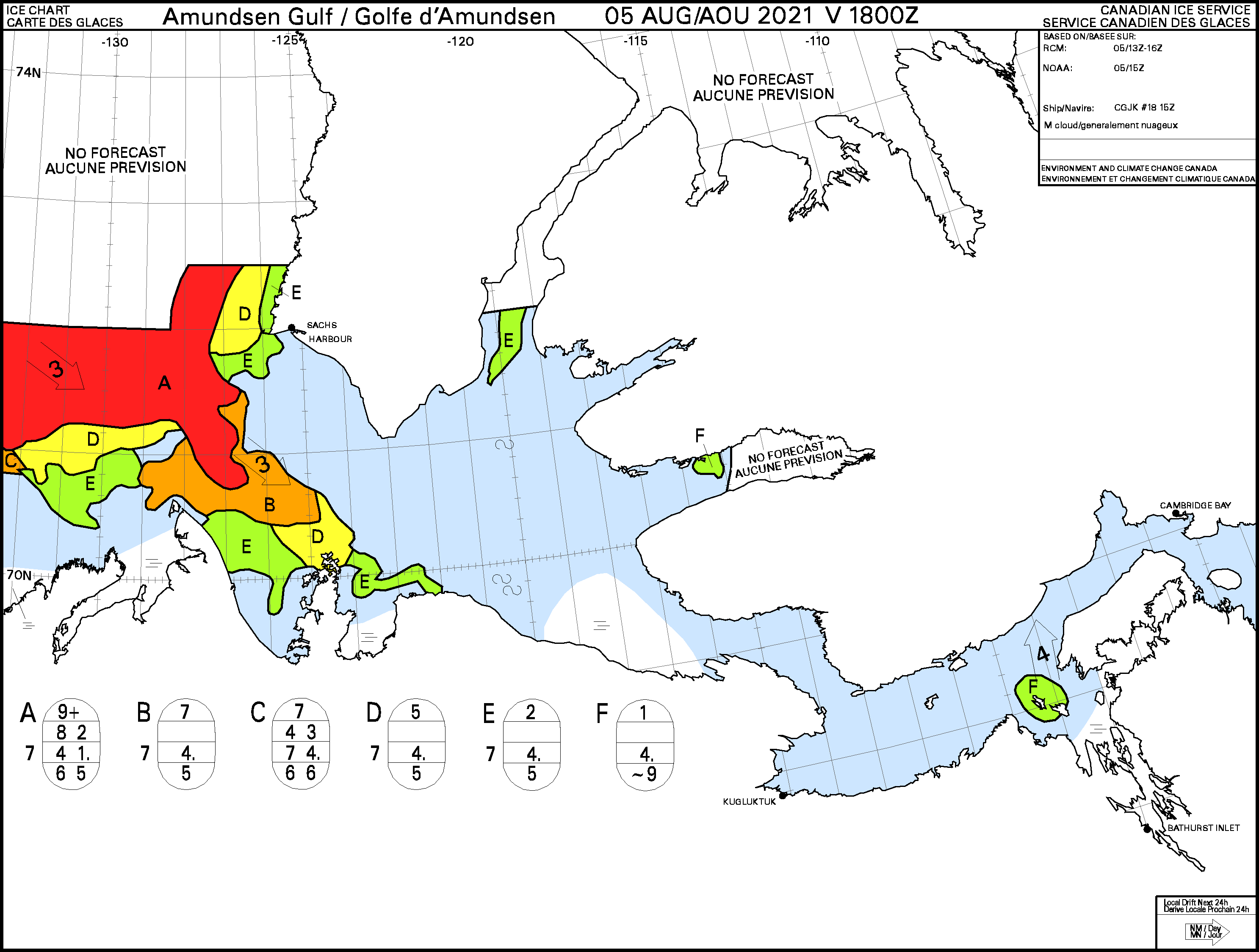
Using our traditional criterion of sea ice concentration <= 6/10 on the CIS charts route 6 through the Northwest Passage is now open, albeit only just! We’ve been waiting on CIS coverage of the Franklin Strait area, and here it is:
Here too are the “choke points” at Cape Bathurst:
and Point Barrow:
Route 4 is still suffering from a section of 7-8/10 concentration near Resolute:

Here’s a very clear view from on high of the remaining sea ice on the southern routes through the Northwest Passage:

The Canadian Ice Service’s map of the area reveals that a narrow passage of <= 6/10 concentration ice is indeed open again east of King William Island:
After oscillating between “open” and “closed” every day or two, the Northwest Passage has now been “open” for 3 consecutive days. However that looks as though it might well change again in the not too distant future:
The Canadian Ice Service has started coverage of the Parry Channel, quite possibly for the benefit of USCGC Healy:

Meanwhile further south, as one narrow door opens to Gjoa Haven:

another one closes at Cape Bathurst:
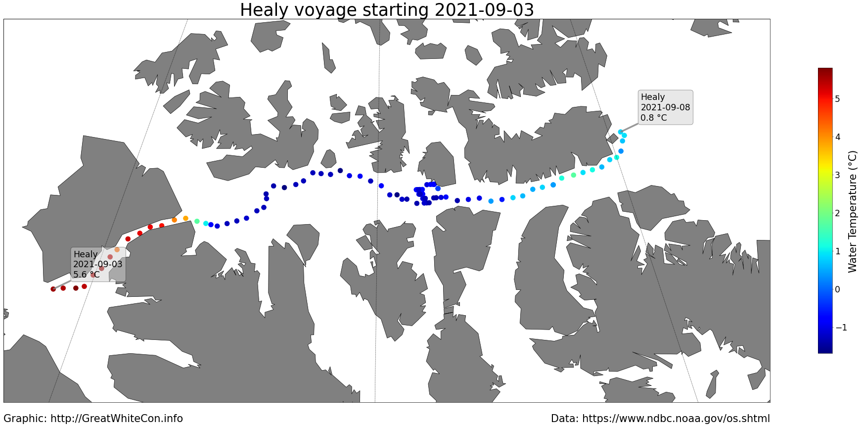
USCGC Healy has completed its voyage through the CAA using route 2 and has emerged into Baffin Bay. Here is a map of the water temperature measured along the way:
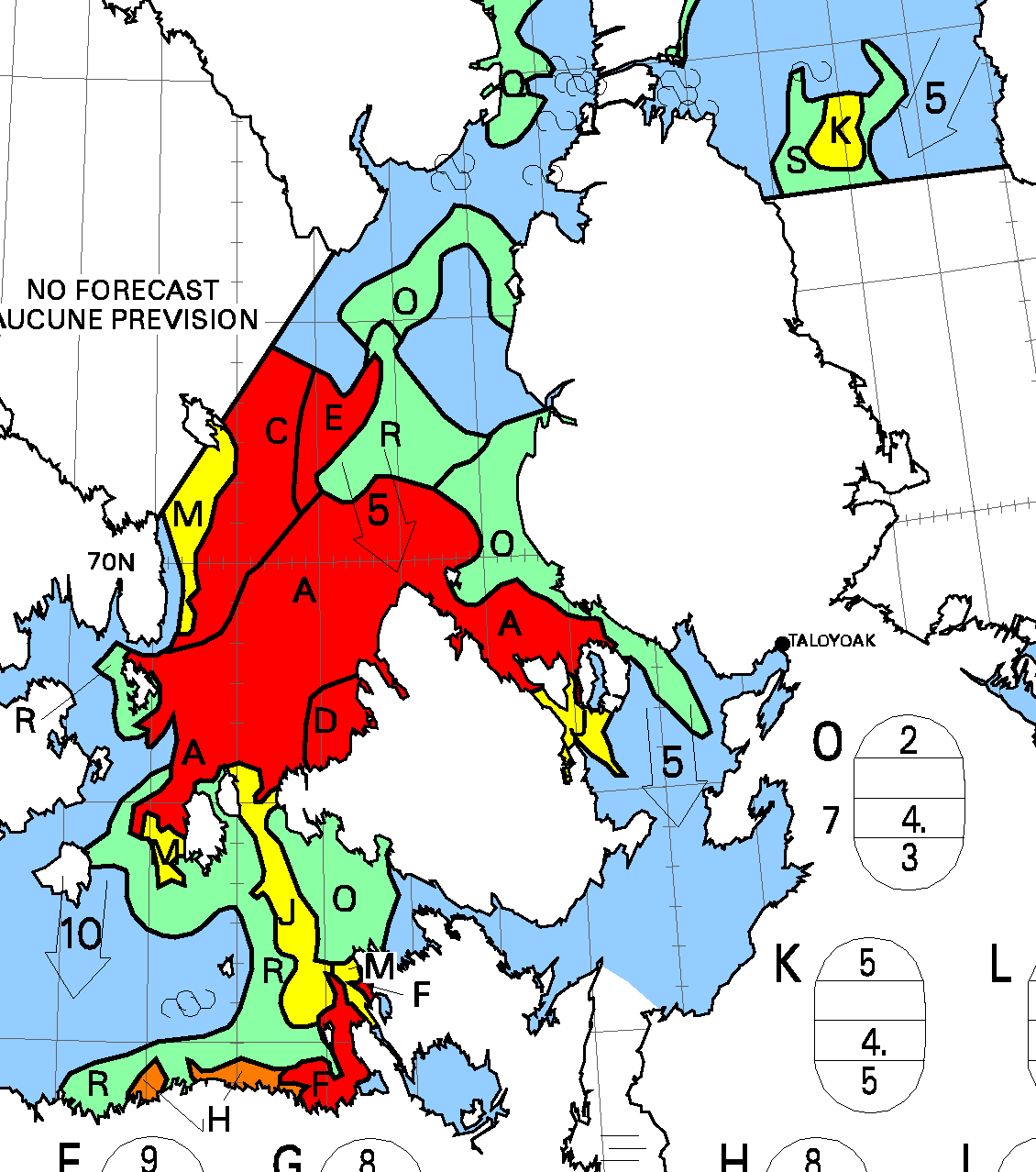
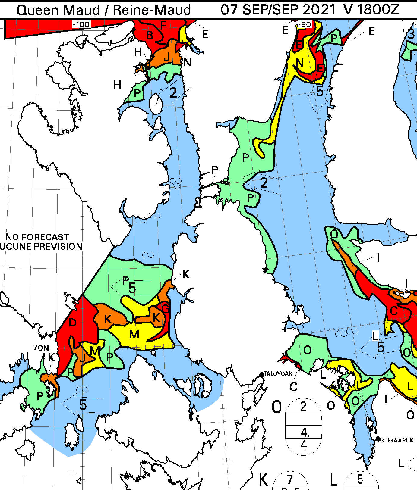
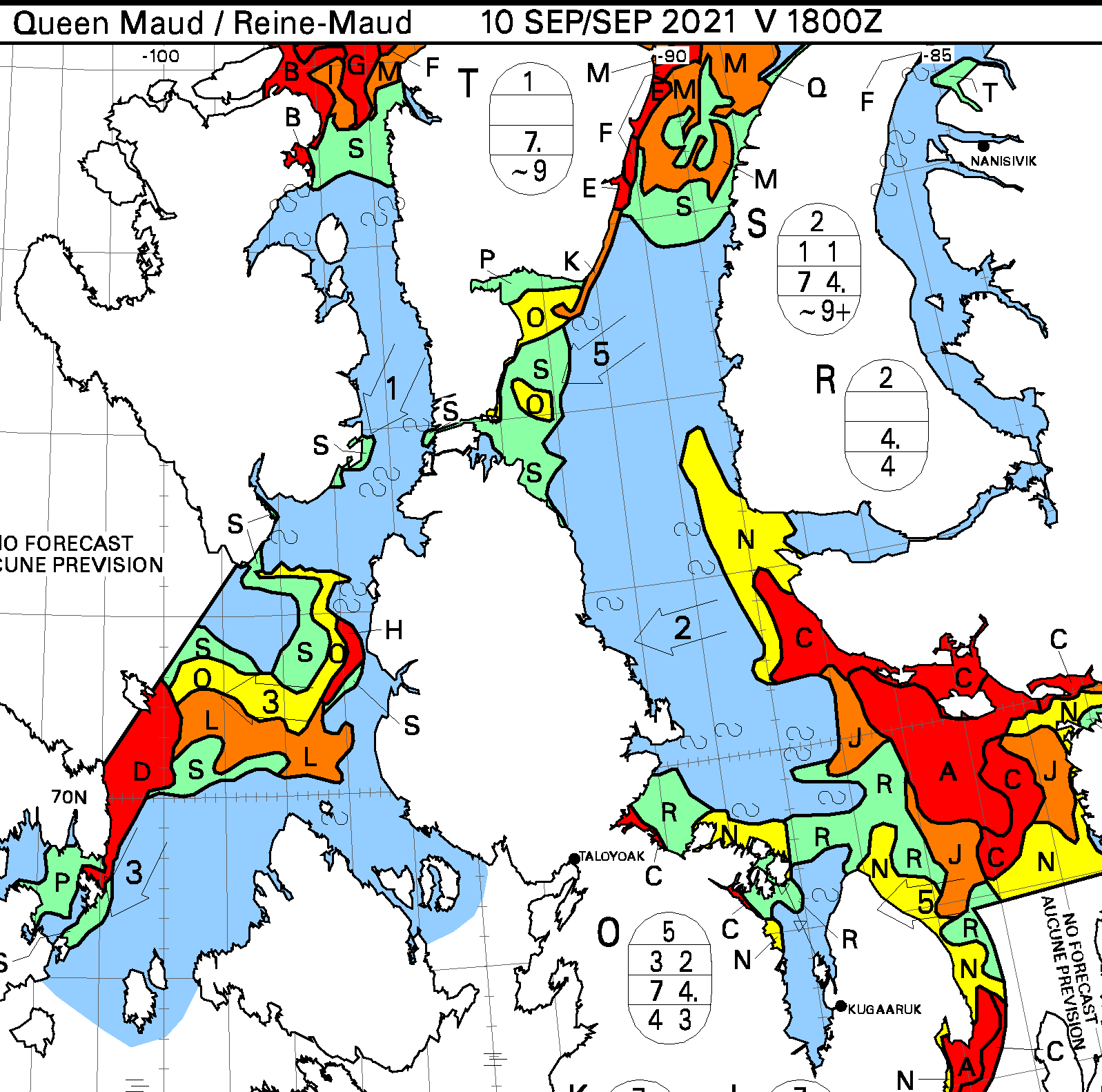
The northern entrance to Peel Sound is now blocked, but there is still a route via Prince Regent Inlet. Further south the ice in the Victoria and Franklin Straits is starting to disintegrate. The route along the coast of the Boothia Peninsula is blocked once again, but a <= 6/10 passage has opened through Larsen Sound and Victoria Strait on route 5:
The northern entrances to both Peel Sound and Prince Regent Inlet are now both blocked by old ice that has been flushed through the Canadian Arctic Archipelago:
Another Royal Wagenborg ice hardened cargo vessel, Amazoneborg, is currently approaching the western entrance to Bellot Strait, as is CCGS Terry Fox:

Given that the northern exits to both Peel Sound and Prince Regent Inlet are full of old ice it will be interesting to see where Amazoneborg heads next, and whether she will be accompanied by an icebreaker:

A clear(ish) view of the iciest bits of the southern route through the Northwest Passage, using false colour to help distinguish ice from clouds:
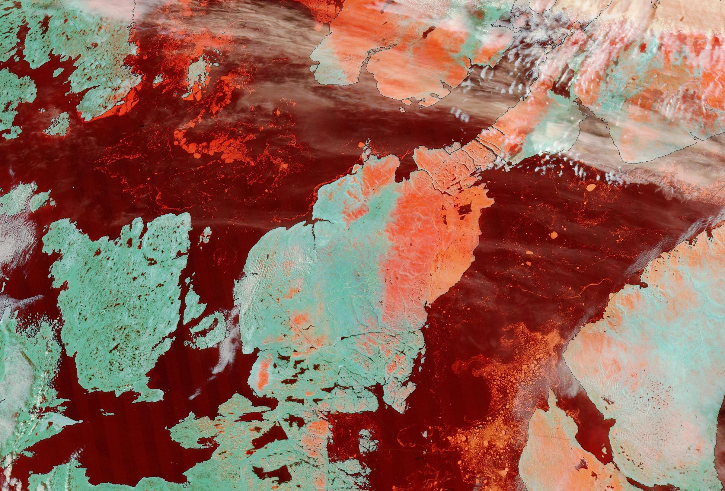
For comparison purposes here too is the Canadian Ice Service’s chart of the same region, albeit rotated somewhat:

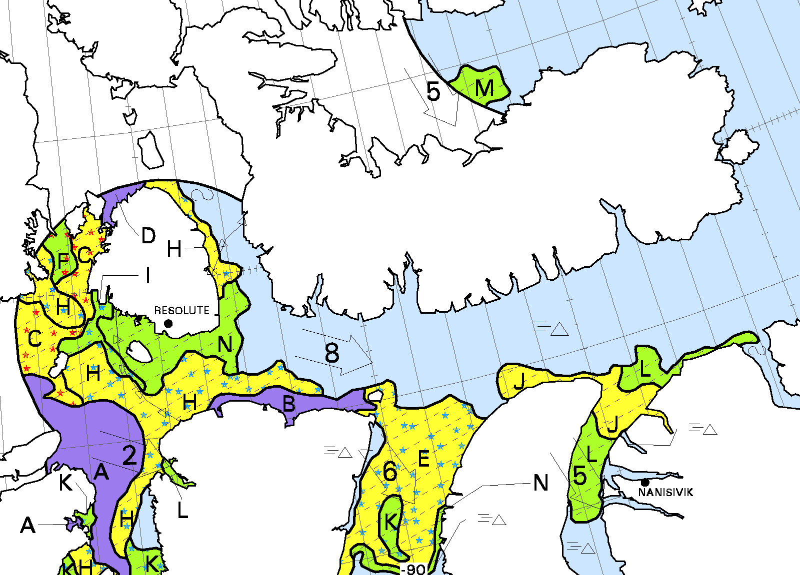
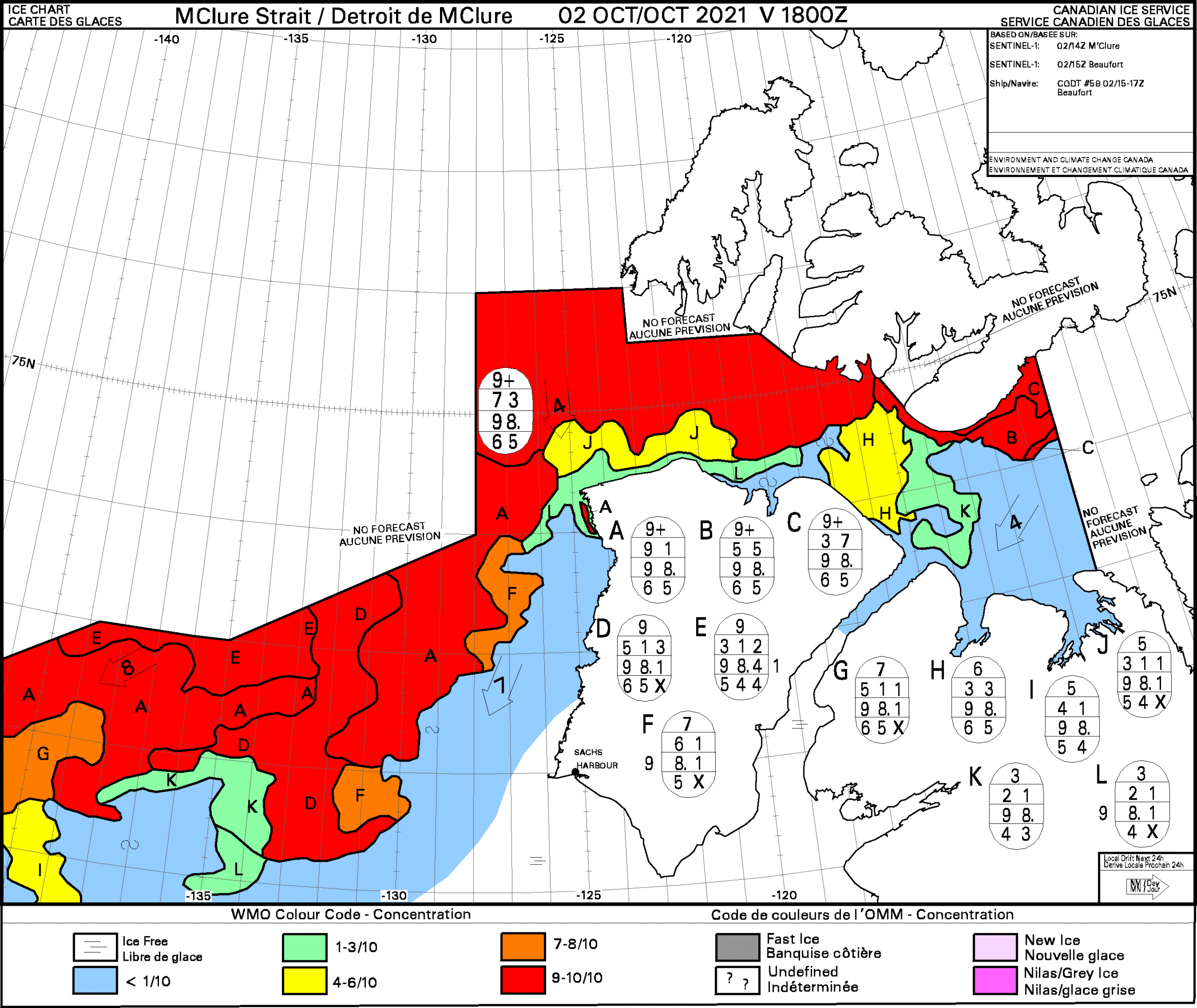
The Canadian Ice Service started coverage of the McClure Strait a few days ago. Here’s today’s concentration chart:
I’ve finally discovered why. Here is the latest tracking map for CCGS Amundsen:

An hour or so ago Amundsen hadn’t yet encountered any sea ice. Here’s the evidence:

Christian Katlein from the Alfred Wegener Institute caught up with CCGS Amundsen last night:
Here’s episode one of his video log of the forthcoming “Dark Edge” expedition:
Watch this space!
2017 – 32 transits
2018 – 3 transits
2019 – 27 transits
2020 – 7 transits
2021 – ?
A good question Neil!
Will Covid-19 constraints keep the “pleasure craft” out of the CAA this year, as they (almost!) did in 2020?
It seems as if they will. From February 4th:
https://www.canada.ca/en/transport-canada/news/2021/02/government-of-canada-announces-one-year-ban-for-pleasure-craft-and-cruise-vessels.html
The Canadian Ice Service have begun detailed coverage of (a small part of!) the CAA:
After the fire that cut short her Arctic activities last year the US Coast Guard icebreaker Healy will be passing through the Northwest Passage in September as part of a circumnavigation of North America:
https://content.govdelivery.com/accounts/USDHSCG/bulletins/2e87c45
In possibly related news see also:
https://www.canada.ca/en/department-national-defence/news/2021/06/her-majestys-canadian-ship-harry-dewolf-becomes-the-first-arctic-and-offshore-patrol-ship-commissioned-by-the-royal-canadian-navy.html
For the first time in nearly 25 years, the Royal Canadian Navy (RCN) will commission a new warship. Her Majesty’s Canadian Ship (HMCS) Harry DeWolf will enter active service following a commissioning ceremony in Halifax on June 26. The ship is the first of six Arctic and Offshore Patrol Ships (AOPS) set to be delivered to the Navy over the coming years, bringing with it new capabilities and a renewed focus on operations in the Arctic region. It’s the RCN’s first ice-capable vessel since the former HMCS Labrador was transferred away from DND in 1958 — a move signed off on by Vice-Admiral Harry DeWolf himself…
HMCS Harry DeWolf is scheduled to participate in the maritime portion of Operation NANOOK in August 2021, following which it will transit through the Northwest Passage, and carry on to circumnavigate North America.
In the latest edition of Arctic Sea Ice News the NSIDC say that:
Meanwhile recent winds seem to have done a fairly good job at clearing out a coastal path along “Amundsen’s Route” through the Northwest Passage:
That seems “meaningful” to me!
Route 5 might be doable, but the ice looks pretty choked on the southeastern tip of Victoria Island. Maybe it opens, maybe not. Other routes not looking good, IMHO, but do you see some possibilities?
Route 6 to the east of King William Island “opened” for a day according to the criterion in the OP, albeit not for commercial traffic unsupported by an icebreaker! However it has now closed again:
Much like last year, I was idly glancing at the MarineTraffic web site today when I spotted a “pleasure craft” located at the western entrance to Bellot Strait:
Unlike last year a Google search has yet to reveal to me the name of the “small vessel” in question.
Glancing at MarineTraffic once again I spotted a “cargo vessel” successfully passing east to west through the Bellot Strait:
There is now no sign of the alleged “pleasure craft” displayed on August 16th
The cargo vessel in question is now following closely behind an ice breaker as it crosses Larsen Sound:
I suspect the positions of the two vessels were logged at different times.
It seems that the cargo vessel in question is the Nunalik, whose track is visible via Sentinel 2:
A second “cargo vessel” is currently crossing Larsen Sound:
In this case accompanied by CCGS Terry Fox:
According to the latest CIS ice concentration map the Northwest Passage has still not “reopened” for “adventurous pleasure craft”:
Nunalik appears to have stopped off at Bathurst Inlet:
Cargo vessel #2 has reached Taloyoak:
Meanwhile a variety of “pleasure craft” and “cargo vessels” can be found near the eastern entrance to the Northwest Passage:
One of the latter is Royal Wagenborg’s ice class 1A Albanyborg, whose destination is listed as Onsan, Korea.
In the absence of a paid subscription to a satellite tracking service this is supposition on my part. That said, it looks to me as though Albanyborg has successfully made her way through the CAA.
In addition sister ship Atlanticborg has passed through the Bellot Strait en route to Osaka, Japan:
Albanyborg has negotiated all the potential “choke points” and is now heading for the Bering Strait. Atlanticborg is in the Amundsen Gulf heading for Cape Bathurst:
Meanwhile CCGS Terry Fox is leading what I presume is NEAS’s Sinaa (AKA cargo vessel #2), engaged in the 2021 sealift, back through the Bellot Strait:
One of the “pleasure craft near the eastern entrance to the Northwest Passage” is now exploring Lancaster Sound:
As surmised above, the Northwest Passage is now “closed” yet again east of King William Island:
USCGC Healy is currently making her way through the Canadian Arctic Archipelago, and appears to be using Route 2 via the Prince of Wales Strait:
Two more commercial vessels have made their way safely through Bellot and Victoria Straits, including the tanker Gaïa Desgagnés which has joined Harry DeWolf in Kugluktuk:
Another tanker is approaching the eastern entrance to Bellot Strait:
So, were there any full crossings of the NW passage this year?
In brief, yes. Assuming that “full” means crossing the Arctic Circle twice then at a minimum:
Completed “commercial”: Albanyborg and Atlanticborg, east to west
Completed “research”: Healy, west to east
En route “military”: Harry DeWolf, east to west
En route “commercial”: Amazoneborg, west to east
In the latest exciting news from the Northwest Passage an intrepid Chinese artist has sensibly decided that discretion is the better part of valour when it comes to navigating the CAA at this time of year in a solar powered vessel with a broken solar panel.
In more “Shock News!” that’s not how the Chinese media report the story. Much more at:
https://GreatWhiteCon.info/2021/09/chinas-arctic-ambitions/
In answer to the question I posed earlier today, Amazoneborg has headed through the Bellot Strait and is now following Terry Fox towards the ice currently blocking the north of Prince Regent Inlet:
Terry Fox has obviously concluded that Amazoneborg is now past the worst of the old ice:
Sadly Terry does not report water temperature, but the coldest air temperature he experienced on his recent trip north is -1.3 °C
Amazoneborg has now emerged safely from Lancaster Sound into Baffin Bay:
Intriguingly the MarineTraffic live tracking map suddenly shows a “pleasure craft” heading for Cambridge Bay.
Amundsen encountered some sea ice in the McClure Strait at midnight UTC.
Then the sun went down!
Amundsen has been heading north, and has now found some serious ice at long last:
A fine view of the sun setting over McClure Strait, courtesy of CCGS Amundsen:
An interesting satellite image of McClure Strait via the CIS.
Click on the image to zoom in:
https://twitter.com/ECCC_CIS/status/1446087924878127110