Tag Archives: Greenland Sea

Facts About the Arctic in May 2025

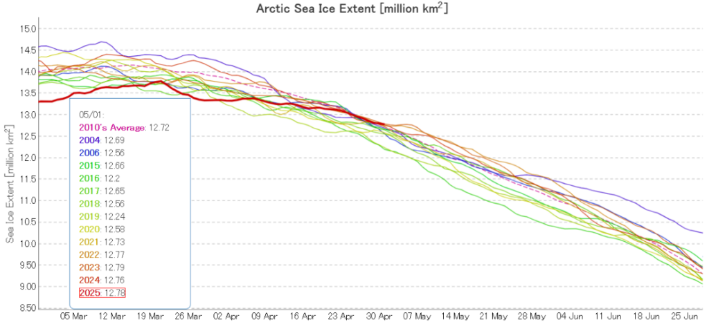
JAXA/ViSHOP extent is no longer “lowest for the date”! After “flatlining” for most of April the metric is now in the midst of a close knit group of the other years in the 2020s:

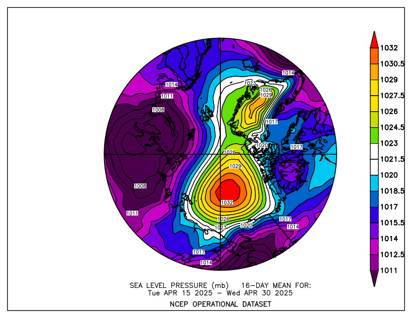
The high pressure area over the Central Arctic persisted through the second half of April, and so did the consequent drift of ice from the Pacific side of the Arctic to the Atlantic periphery:

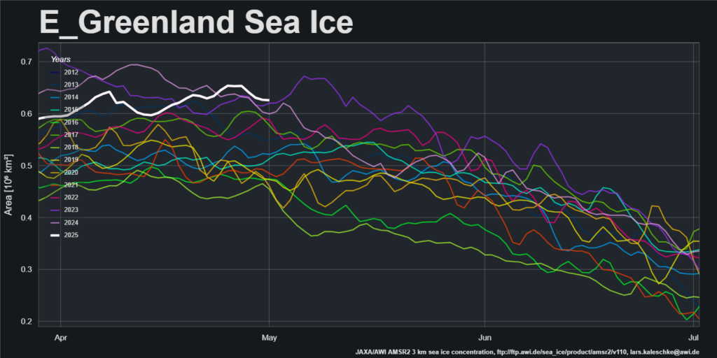
AWI’s sea ice area for the Greenland Sea is currently “highest for the date” in the AMSR2 record that started in July 2012:

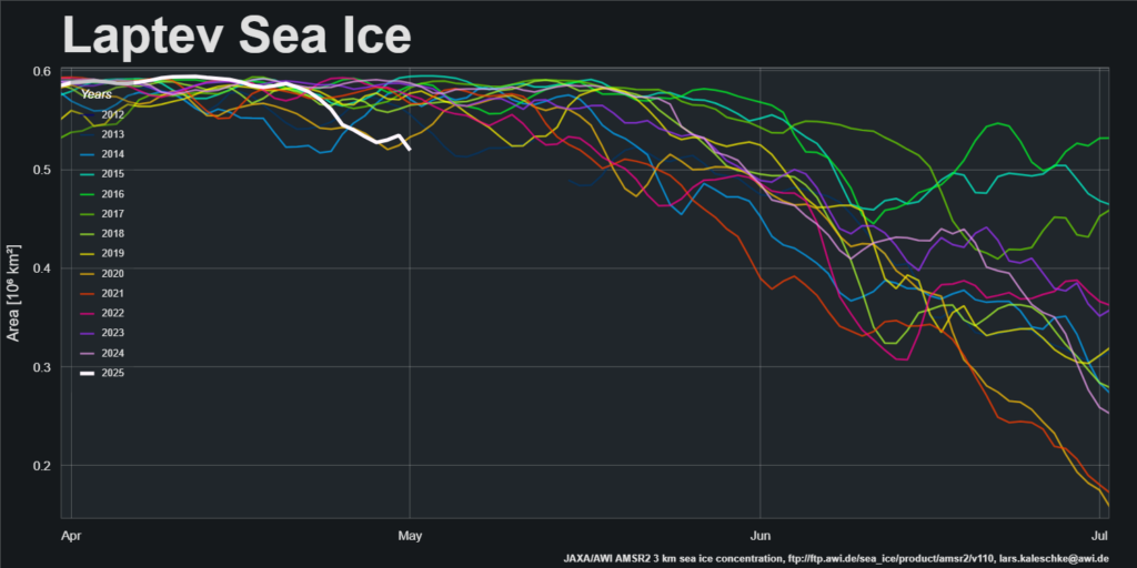
The offshore winds along the Laptev Sea coast have continued, and sea ice area is now “lowest for the date”:

The first signs of a break in the high pressure dominance are appearing. GFS currently forecasts that a low pressure area will enter the Central Arctic, bring above zero temperatures over the Kara Sea on Sunday:

Continue reading Facts About the Arctic in May 2025

Facts About the Arctic in October 2024

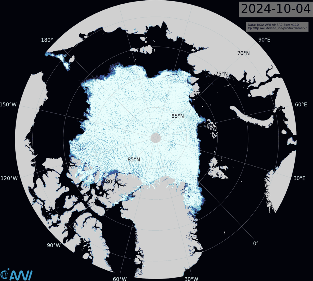
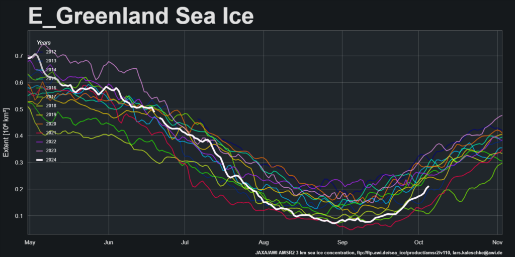
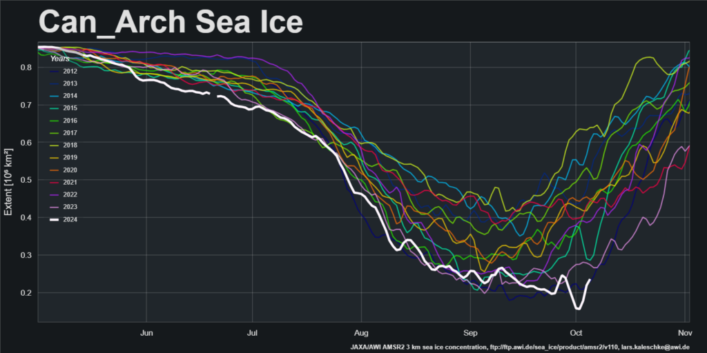
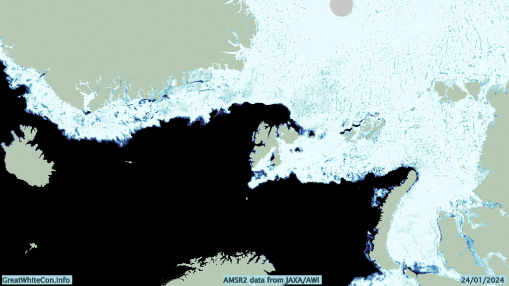
The JAXA extent graph is currently not updating, so let’s begin this month with the latest AMSR2 sea ice concentration map from the Alfred Wegener Institute. Click the image to see a ~10 Mb animation of the last four weeks:

Note in particular the restart of export into the East Greenland Sea via the Fram Strait:

and the movement of ice within the Canadian Arctic Archipelago:

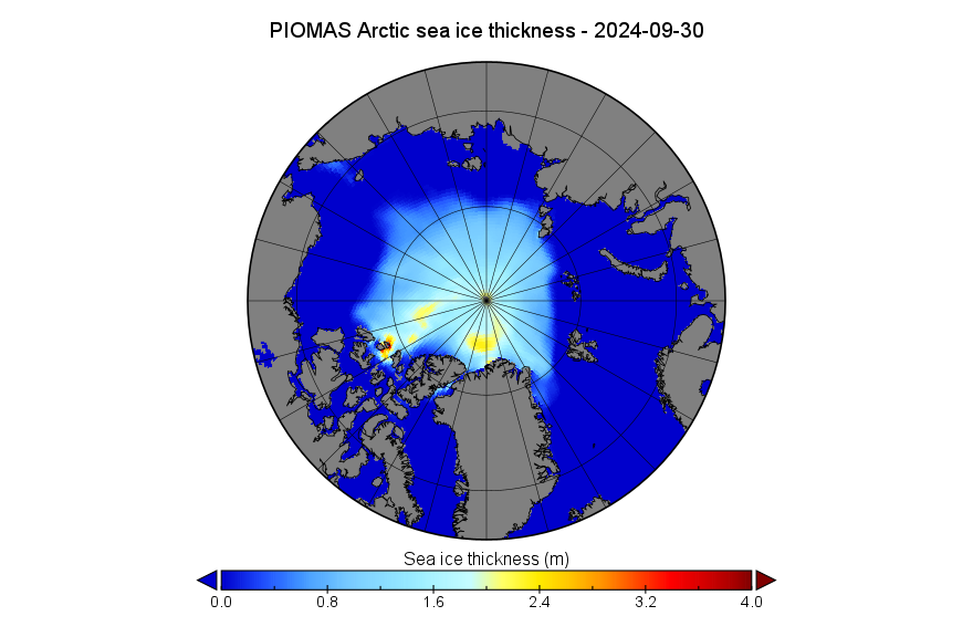
The PIOMAS gridded thickness data for September 2024 has been released:

Continue reading Facts About the Arctic in October 2024

Facts About the Arctic in March 2024

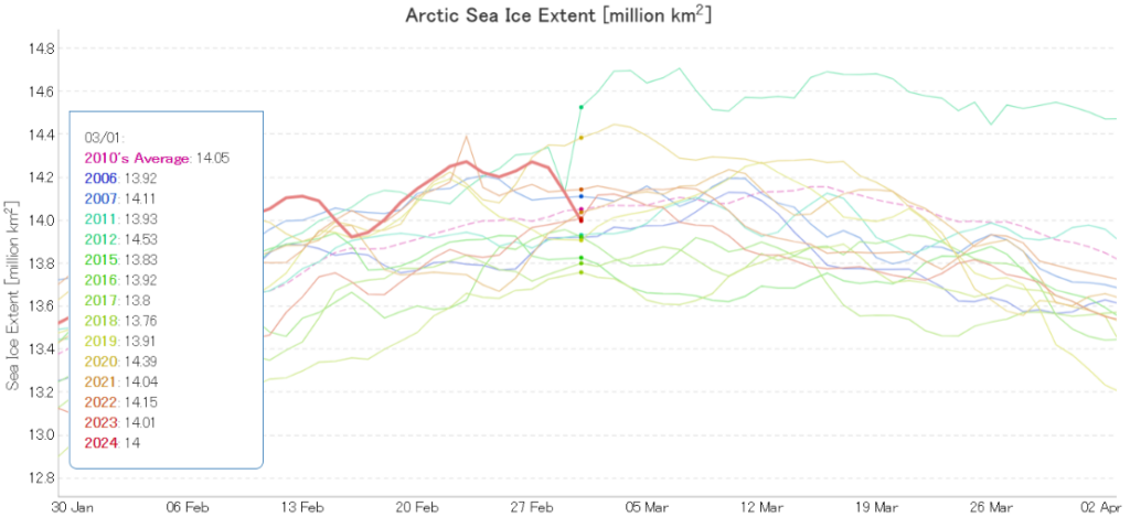
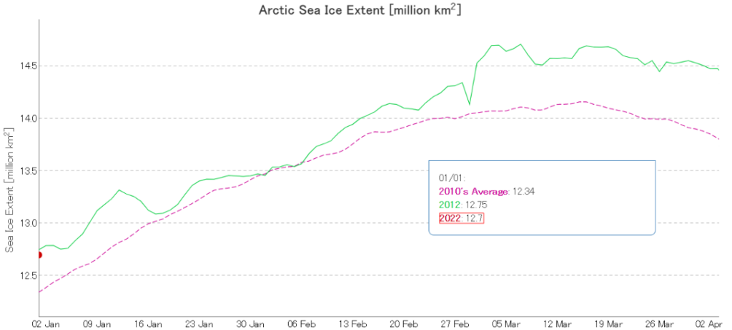
It looks as though the 2024 Arctic sea ice melting season has begun. For much greater detail see the 2024 maximum extent thread. However, here’s the latest JAXA Arctic sea ice extent graph:

Here too is an animation of sea ice motion on the Atlantic periphery, showing the effect of the passage of several Arctic cyclones through the area over the past 5 weeks or so:

[Update – March 4th]

My usual start of month processing hasn’t gone according to plan. Thanks to Lars Kaleschke at the Alfred Wegener Institute for the following information:

SMOS went into safe mode on 22 February 2024 at 05:10 UTC for reasons that are still under investigation.

The spacecraft has been back in nominal mode since 25 February 2024 and on 27 February 2024, the MIRAS instrument was switched on and is currently performing well.

The reload of the nominal acquisition planning is underway, and if all science data quality checks are positive, nominal data production and dissemination will resume in the coming days.

Continue reading Facts About the Arctic in March 2024

Facts About the Arctic in May 2023

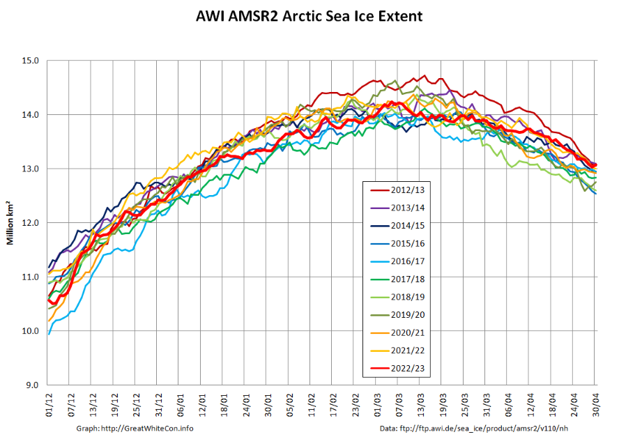
At the beginning of May AWI’s high resolution AMSR2 extent metric is at the top of the historical range:

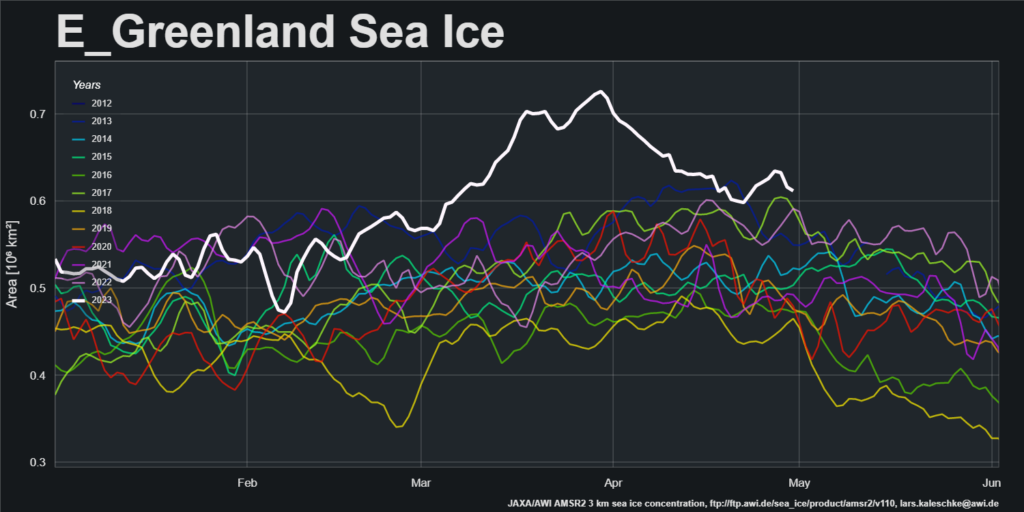
After a period of melt in the East Greenland Sea, export of sea ice from the Central Arctic via the Fram Strait has increased recently:

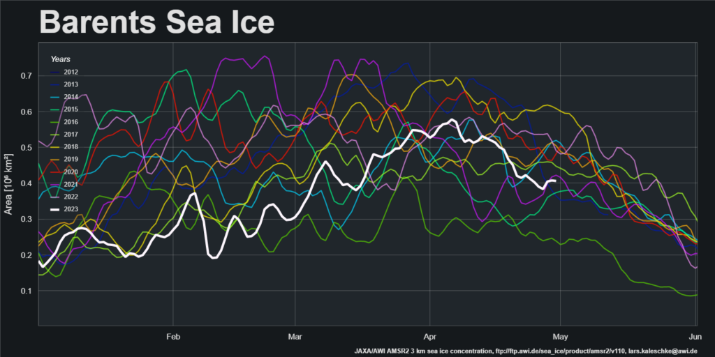
Sea ice area in the Barents Sea peaked in the first week of April and has declined steadily since then:

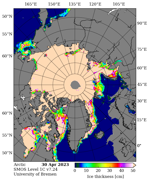
SMOS data is flowing again, and the gaps have been filled. Here’s the final pre melt ponding map of the spring:

It reveals large areas of thin ice that have recently developed in the Kara Sea. Here’s a pseudo colour glimpse of the region through the clouds:

Continue reading Facts About the Arctic in May 2023

Facts About the Arctic in January 2022

2021 has been and gone, so first of all may I wish all our readers a very Happy New Year.

Sadly it’s not been a happy start to 2022 for the inhabitants of Boulder, Colorado, home of the National Snow and Ice Data Center. According to the Denver Post:

The Marshall fire destroyed an estimated 991 homes in Boulder County, damaged 127 more and may have killed three people, Sheriff Joe Pelle said Saturday afternoon.

Pelle added that the cause of the fire — the most damaging in Colorado history — remains under investigation, and confirmed that sheriff’s officials have served a search warrant on at least one property based on a tip.

Currently, two people are missing in Superior and another is missing in the Marshall area, Pelle said. All three are feared dead as each of their homes was lost to the fire, the sheriff said…

So far, officials say Thursday’s wildfire — exacerbated by 100-mph winds — burned more than 6,000 acres across Boulder County.

The fire destroyed 553 homes in Louisville, damaging 45, Pelle said Saturday. It also destroyed 332 homes in Superior, damaging 60 in that town, and destroyed 106 homes in unincorporated Boulder County, damaging 22…

Officials first thought downed power lines sparked the fire, but have been unable to confirm its origin. The abnormally dry conditions led to what is now the most destructive wildfire in Colorado history.

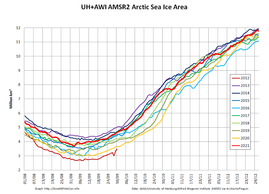
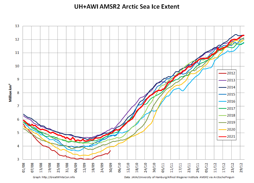
Moving north to examine snow and ice data from the Arctic, let’s start 2022 in traditional fashion with a look at high resolution AMSR2 area and extent:

Both metrics are now near the upper boundary of the last 10 years’ range. The AMSR2 instrument wasn’t launched into orbit until summer 2012, but according to both JAXA and NSIDC data extent on January 1st 2022 is almost identical to the same date in 2012. Regular readers will recall that year went on to produce the lowest annual minimum extent in the satellite era despite recording the highest annual maximum in the decade of the 2010s:

Note that sea ice volume tells a rather different story. Here’s the latest AWI CryoSat-2/SMOS volume graph:

The current near real time data is likely to be revised upwards slightly when the final reanalysis is complete, but even so volume seems likely to remain in the lower half of the recent range at the end of 2021.

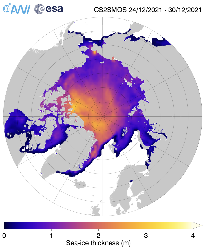
Here too is the AWI Arctic sea ice thickness map:

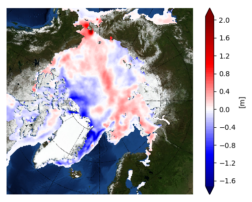
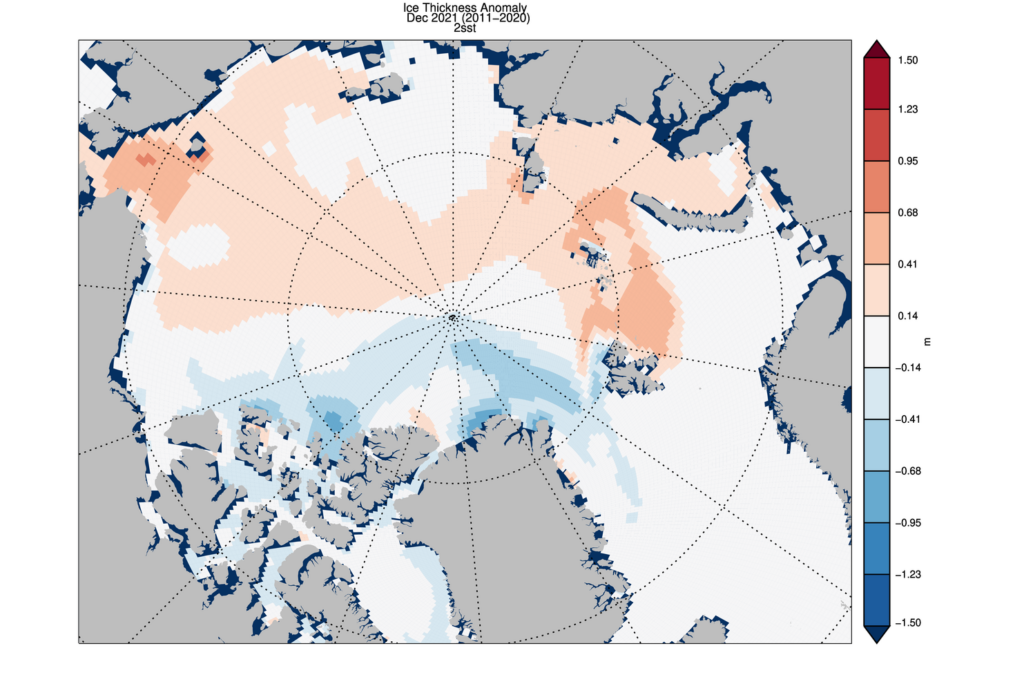
together with the thickness anomaly map from the Finnish Meteorological Institute:

Once again the ice in the so called “last ice area” north of Greenland and Ellesmere Island is thinner than usual, as is the ice in the Fram Strait and East Greenland Sea.

[Edit – January 11th]

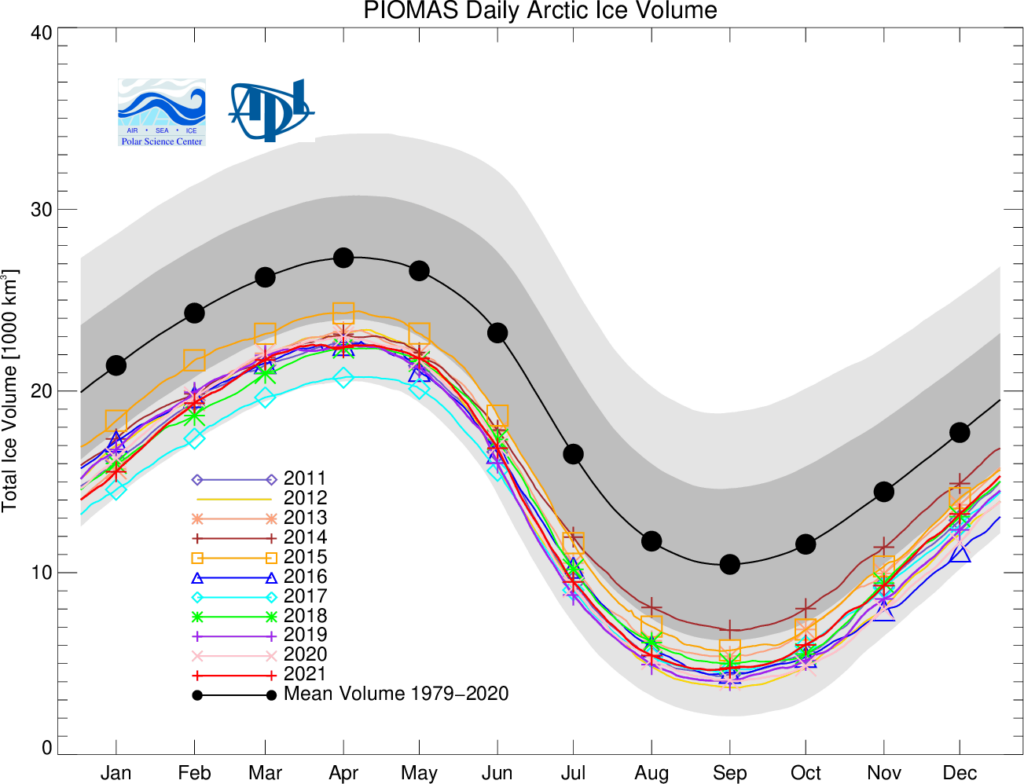
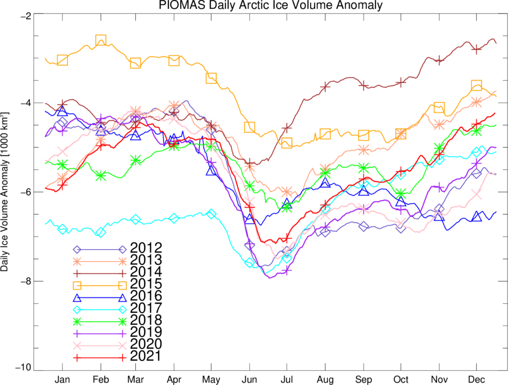
As has been pointed out below, the Polar Science Center has now released the PIOMAS volume data for December 2021:

Average Arctic sea ice volume in December 2021 was 13,300 km3. This value is the 9th lowest on record for December,  about  2100 km3 above the  record set in 2016.   Monthly  ice volume was 51% below the maximum in 1979 and 37% below the mean value for 1979-2020. Average December 2021 ice volume was  1.2  standard deviations above the 1979-2020 trend line.

November and December of 2021 saw relative rapid ice growth  for recent years, bringing the mean ice thickness  (above 15 cm thickness) towards the thicker end of  the recent values.

The ice thickness anomaly map for December 2021 relative to 2011-2020 continues to show anomalies divided into positive and a negative halves with areas of positive anomalies increasing since the two prior months and stretching from the Beaufort, over the pole and into the Barents.  Negative anomalies stretching from Fram Strait,  North of Greenland and along the Canadian Archipelago. Areas North of Greenland again feature low ice thickness as in prior years.

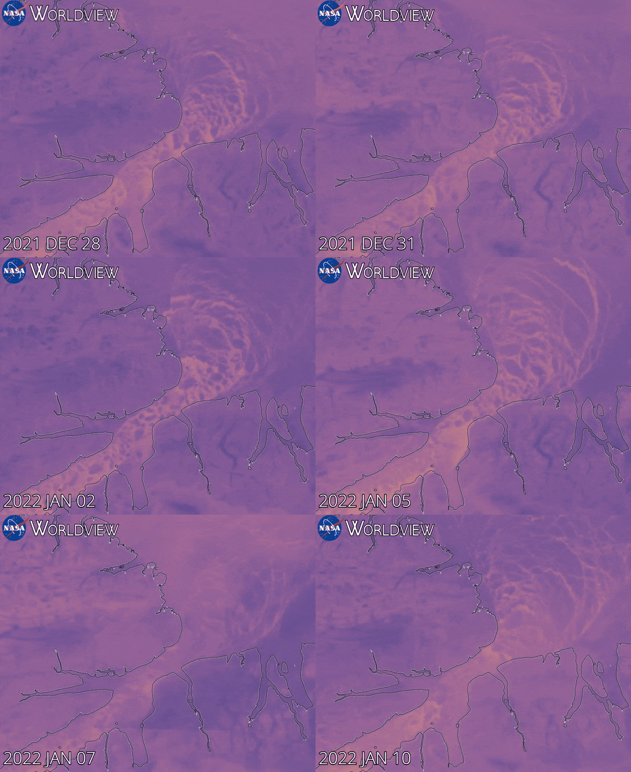
Note that as revealed by this animation from NASA Worldview the sea ice in the Lincoln Sea is currently still breaking up and being exported from the Central Arctic via the Nares Strait:

[Edit – January 25th]

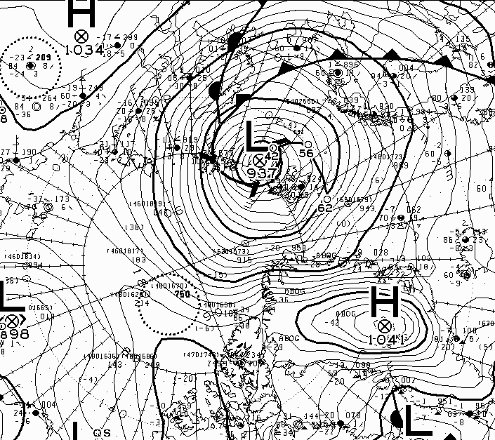
The Atlantic side of the Arctic Ocean has been taking a bit of a battering from what I shall henceforth refer to as the Great Arctic Winter Cyclone of 2022, or GAWC 2022 for short. Unless there’s an even deeper one later in the year of course!

According to the Canadian Meteorological Centre the storm achieved a minimum Mean Sea Level Pressure of 937 hPa at 12 noon UTC yesterday:

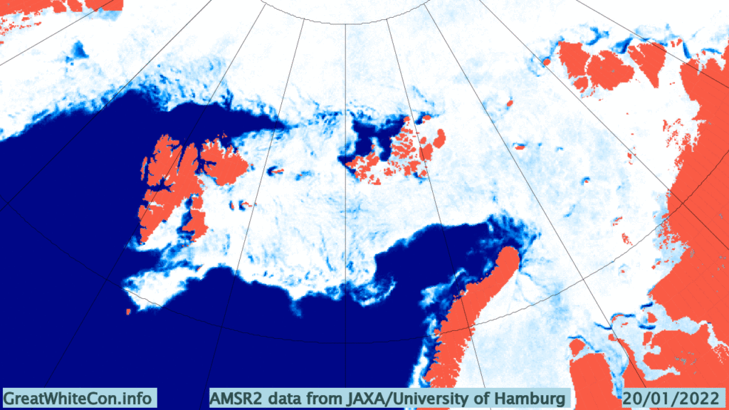
Here are the visible effects of the storm on the sea ice in the area so far, now updated to January 25th:

Watch this space!

The 2021 Arctic Sea Ice Minimum Extent

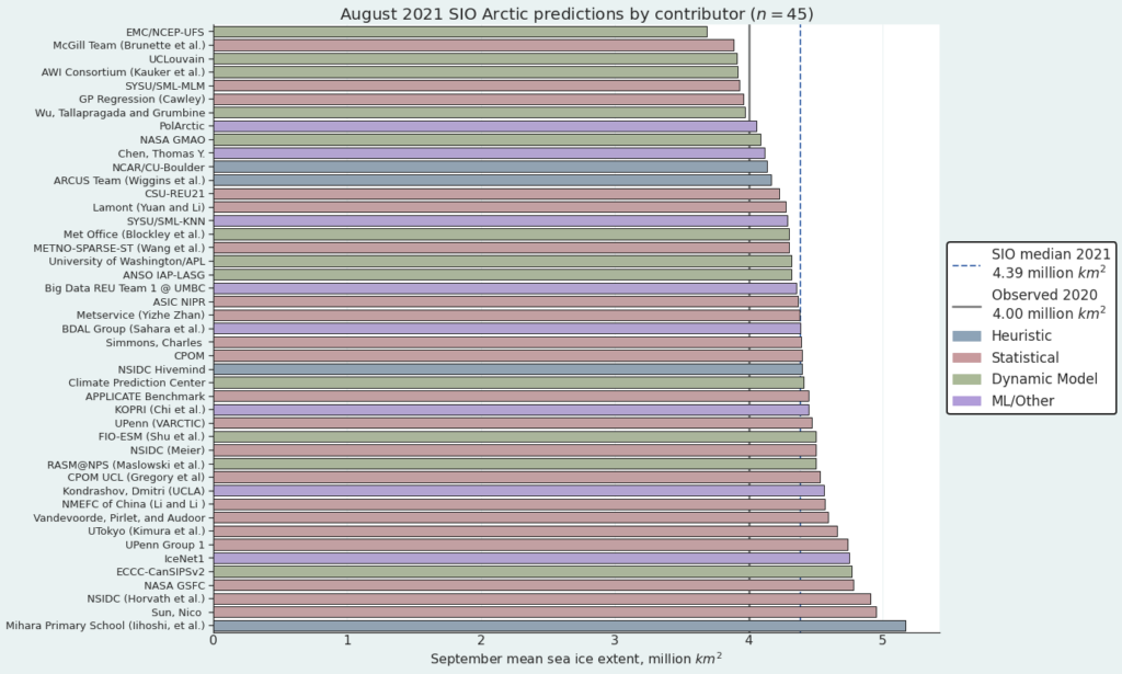
The results of the ARCUS Sea Ice Prediction Network August call have been released, and here is the outlook for the 2021 minimum September mean Arctic sea ice extent:

The median prediction for the mean sea ice extent during the month of September 2021 is 4.39 million km2. According to ARCUS:

As of 22 August 2021, the Arctic sea-ice extent was 5.58 (compared with 25 August 2020 value of 4.43) million square kilometers. Arctic sea-ice extent in 2021 remains well below the climatological median and has closely followed the 2012 values for much of the summer but has diverged to higher sea-ice extent starting in early August. The forecasts continue to support September 2021 mean sea-ice extent being well above the September 2020 value. July sea-ice retreat has been greatest in the Eurasian seas, particularly in the East Siberian Sea, making the 2021 ice edge well north of the long-term median edge in Eurasia. Sea ice retreated since the end of July along the northern coast of Alaska, although the ice edge is near its climatological position, which makes the Beaufort and Chukchi sea ice extent the largest at this time of year since 2006. A tongue of sea ice that has been present all summer continues to extend close to land in the Kara Sea, making the northeast passage likely to remain blocked for the first time in several years. Half the models which provide spatial data to the SIO predict that the tongue is likely to survive.

Now let’s take a look at a range of assorted extent measurements. Here’s the NSIDC’s 5 day average extent:

Continue reading The 2021 Arctic Sea Ice Minimum Extent

Facts About the Arctic in April 2021

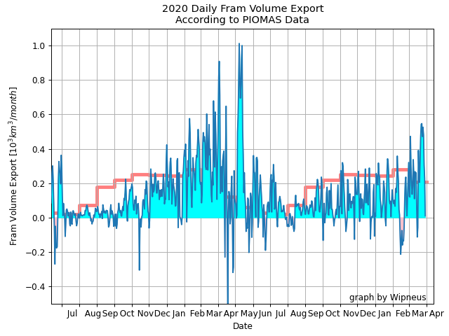
As part of his March PIOMAS gridded sea ice thickness update Wipneus also produced this graph of sea ice export from the central Arctic via the Fram Strait:

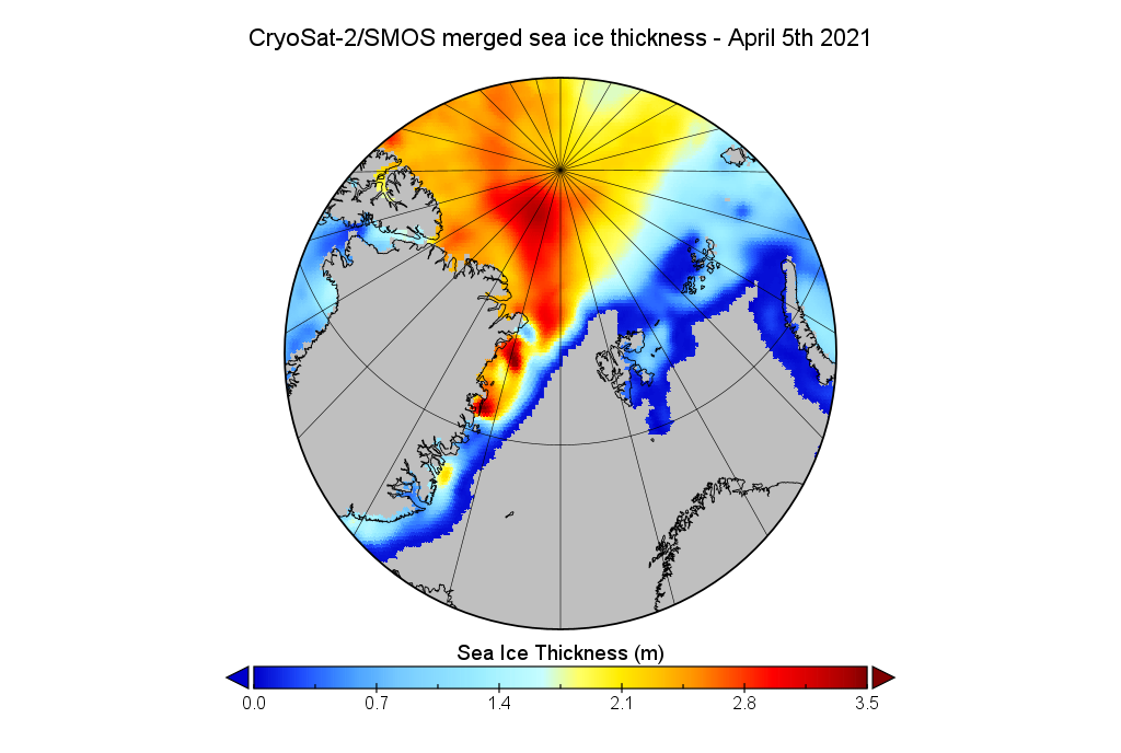
So far this winter export has been remarkably subdued, but that has now changed. A persistent dipole with high pressure over Greenland and low pressure over the Barents Sea is generating strong northerly winds in the Fram Strait, and even bringing some April snow showers to South West England:

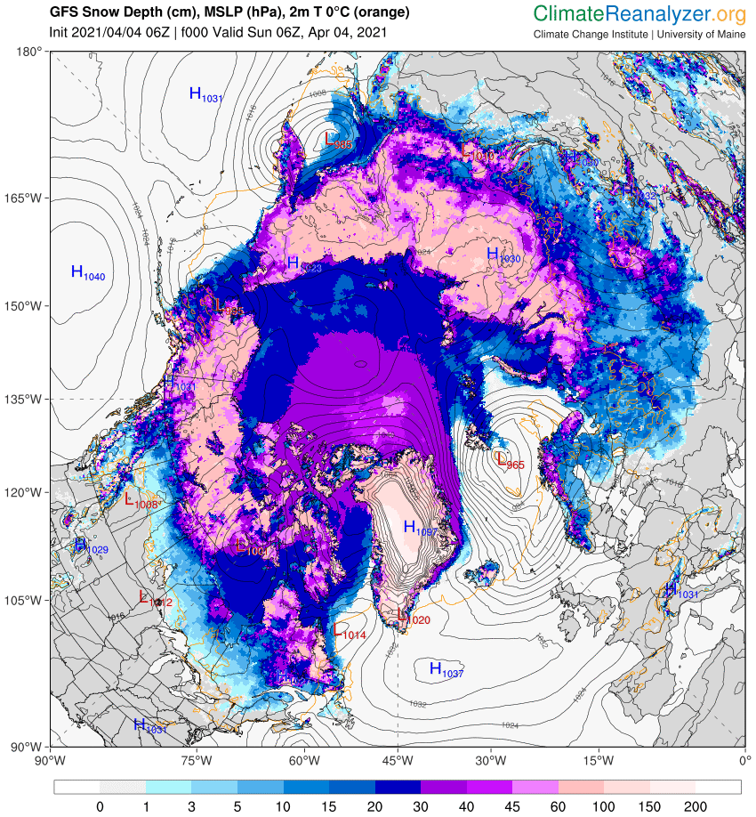
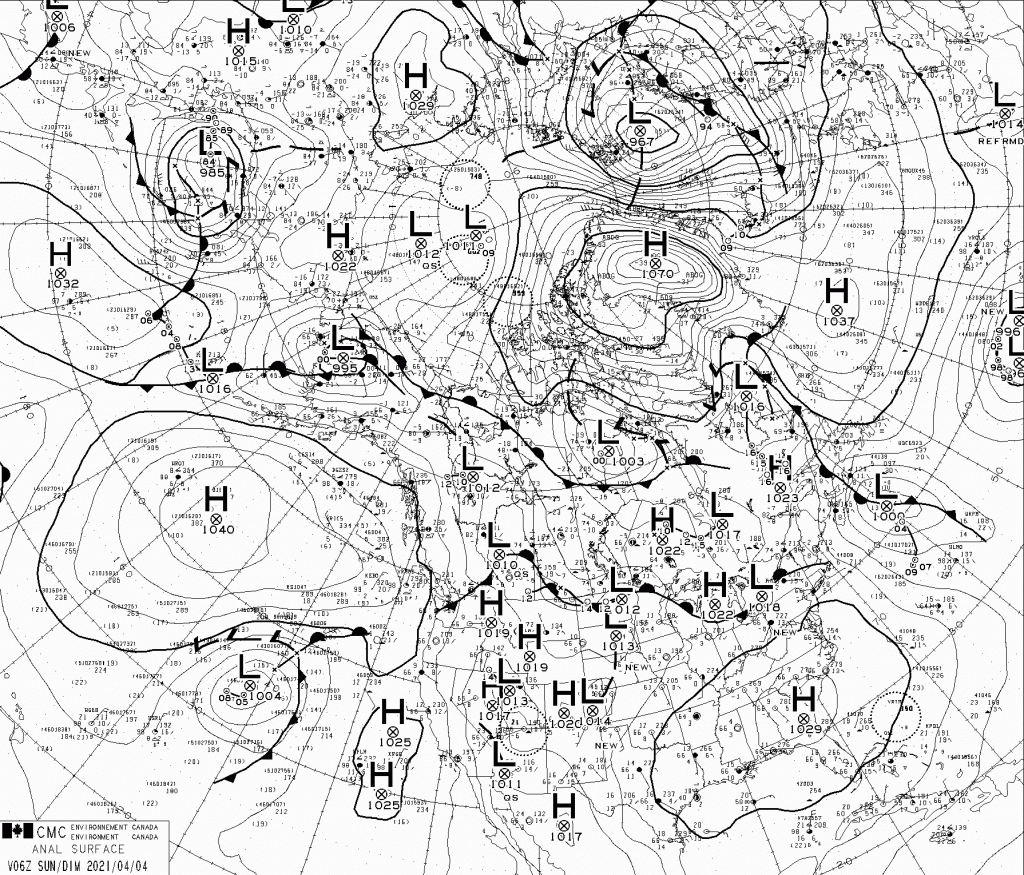
Precisely how high the pressure has been over Greenland is the subject of much debate. See for example this discussion on the Arctic Sea Ice Forum about whether a new world high pressure record has just been set. Different weather forecasting models have come to very different conclusions about the mean sea level pressure of a high pressure area situated over the Greenland ice sheet, which reaches an altitude of over 3,000 metres. Here’s GFS for example, showing 1097 hPa at 06Z on April 4th:

whereas the Canadian Meteorological Centre synopsis for the same time shows a mere 1070 hPa:

At least all the assorted models agree that the isobars are closely packed over the Fram Strait, and hence some of the thickest sea ice remaining in the Arctic is currently heading towards oblivion in the far north Atlantic Ocean:

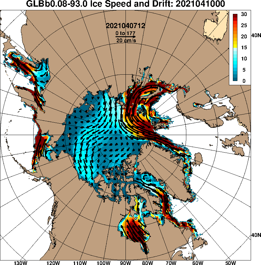
Here’s the US Navy’s sea ice drift forecast for Saturday 10th:

Continue reading Facts About the Arctic in April 2021

The Great Arctic Cyclone of 2018?

Our title for today refers back to the Great Arctic Cyclone of August 2012. There has been some speculation over on the Arctic Sea Ice Blog about whether a similar event is about to occur this year.

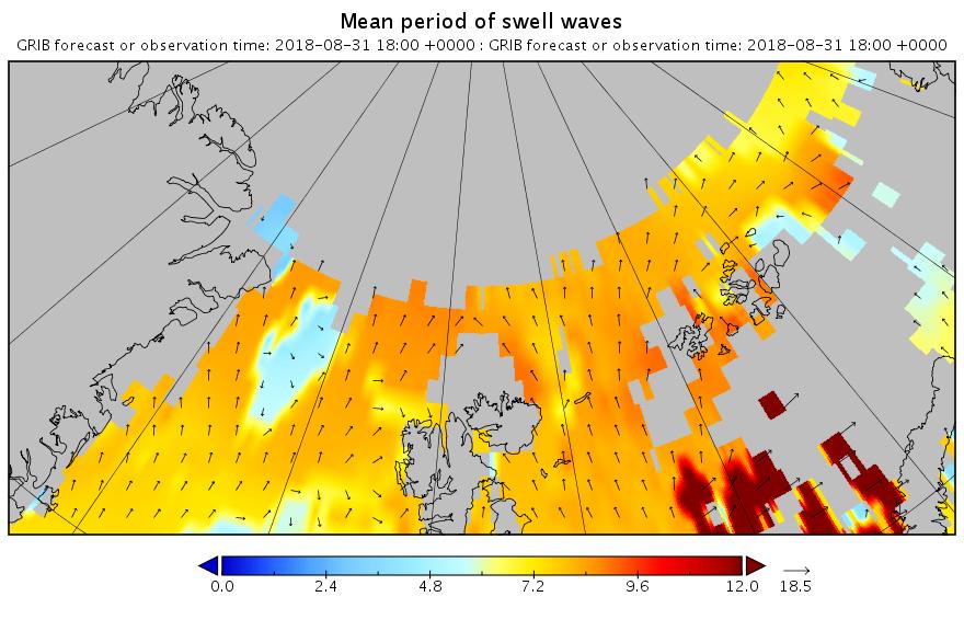
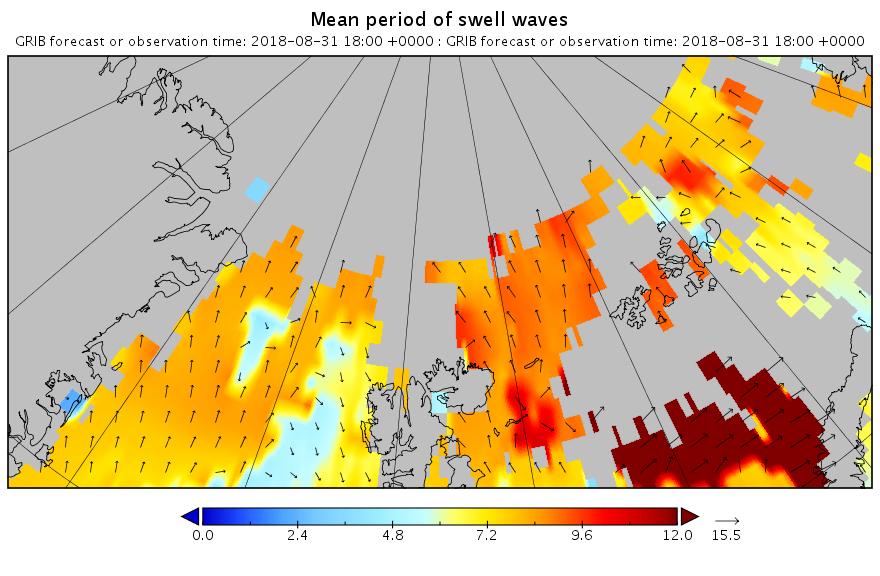
It’s later in the season of course, but as is our wont we always look at the waves first. Here is the current WaveWatch III forecast for the evening of August 31st UTC:
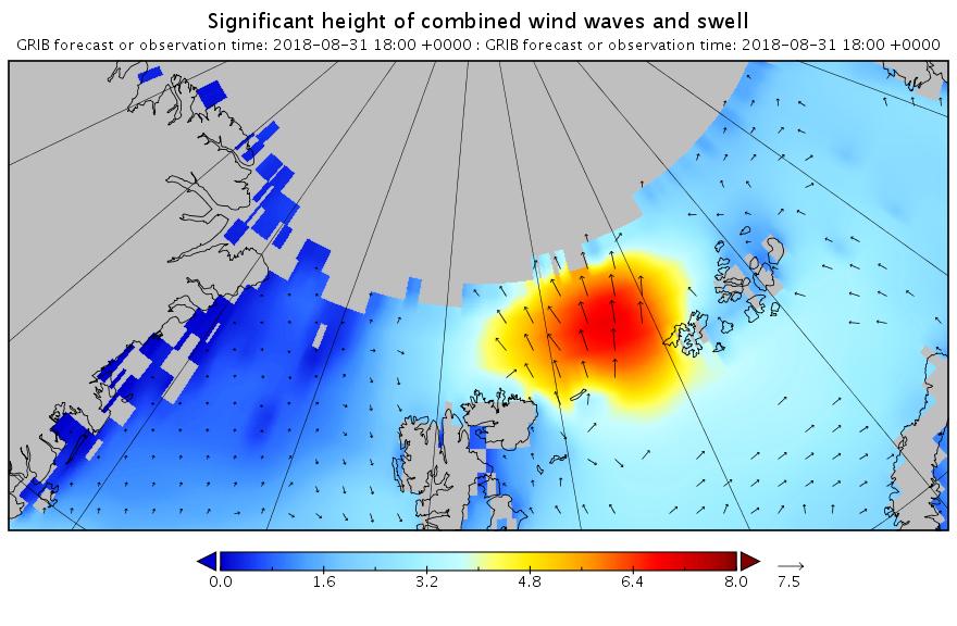
Significant_height_of_combined_w in multi_1.glo_30mext.20180827_00039

Mean_period_of_swell_waves_order in multi_1.glo_30mext.20180827_00039

In summary the forecast shows some very large waves with a substantial period for inside the Arctic Circle directed straight at the ice edge. Let’s follow the forecast over the next few days carefully shall we?


[Edit – August 30th]

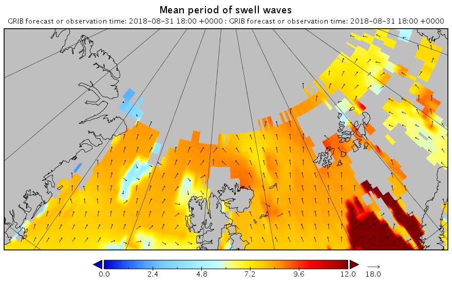
The latest wave forecast for tomorrow evening isn’t as extreme as 3 days ago. Note the change in the significant height scale:
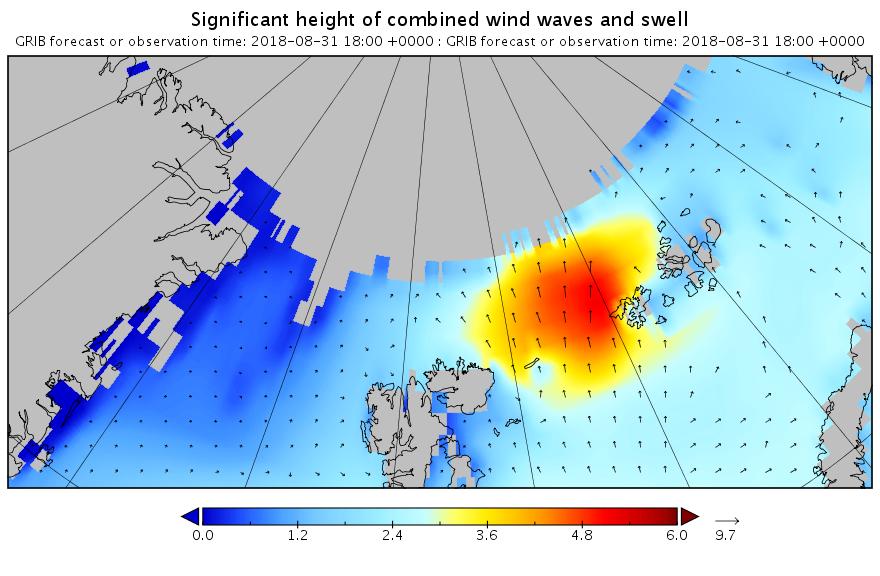
Significant_height_of_combined_w in multi_1.glo_30mext.20180830-06Z_00013

Mean_period_of_swell_waves_order in multi_1.glo_30mext.20180830-06Z_00013

Nonetheless the height and period are still very significant!


[Edit – August 31st]

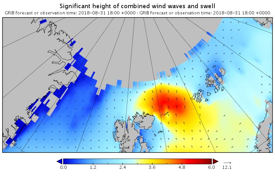
Here’s the latest forecast for 6 PM this evening (UTC):
Significant_height_of_combined_w in multi_1.glo_30mext.20180831_00007

Mean_period_of_swell_waves_order in multi_1.glo_30mext.20180831_00007

Note how the open water across almost the entire map is full of what in the Arctic counts as a long period swell. That means that the forecast for 2 days later looks like this:
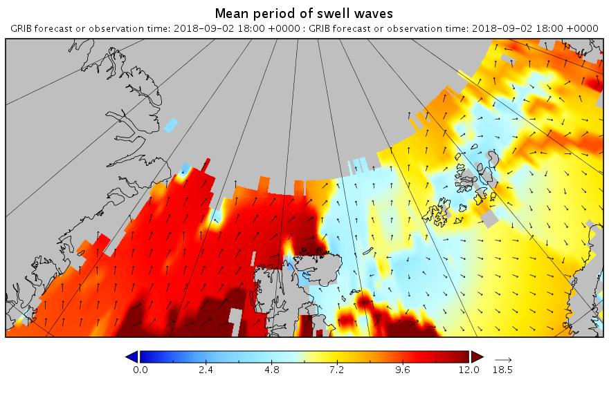
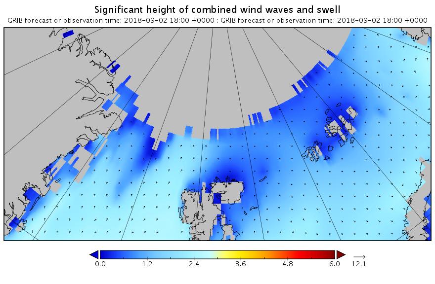
Mean_period_of_swell_waves_order in multi_1.glo_30mext.20180831_00023

Significant_height_of_combined_w in multi_1.glo_30mext.20180831_00023

Less height but with a longer period. All of which means that the sea ice north of the Atlantic Ocean isn’t about to receive a short sharp shock. It has a sustained battering lasting several days to look forward to.


[Edit – September 1st]

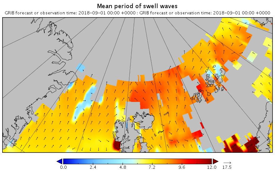
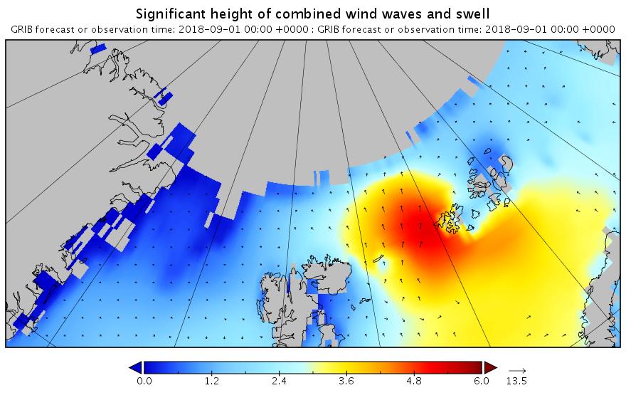
The barrage of assorted swells has begun. Here’s the “hindcast” from midnight last night UTC:
Significant_height_of_combined_w in multi_1.glo_30mext.20180901_00001

Mean_period_of_swell_waves_order in multi_1.glo_30mext.20180901_00001

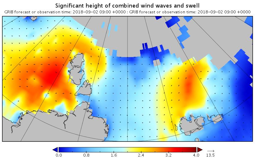
Now lets take a look at tomorrow’s forecast for the Laptev Sea. This is for 09:00 UTC:
Significant_height_of_combined_Laptev.20180901_00012

Mean_period_of_swell_waves_Laptev.20180901_00012

Note once again the change of scale on the wave/swell height map. Nevertheless a 3+ meter swell heading over into the East Siberian Sea isn’t something you see every day.

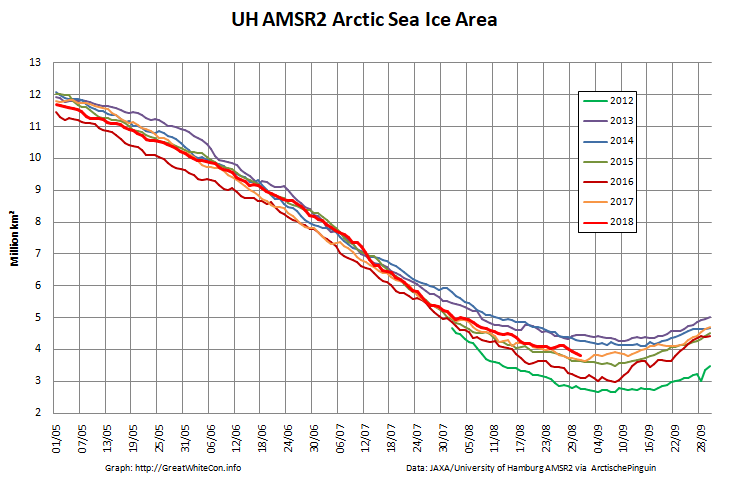
Now were into September the 2018 annual minimum extent can’t be too far away. Extent decline appears to have stalled. However “high res” AMSR2 area is currently falling fast, for the time of year at least:
Arctic-Area-2018-08-31


[Edit – September 2nd]

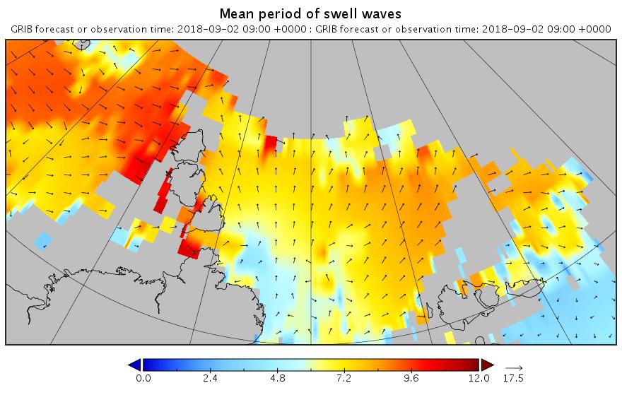
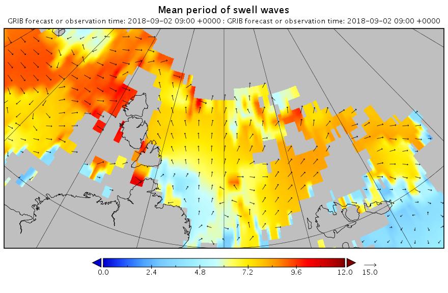
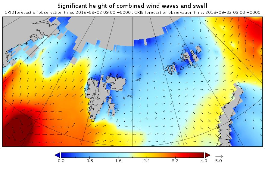
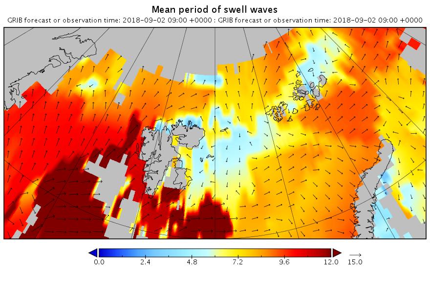
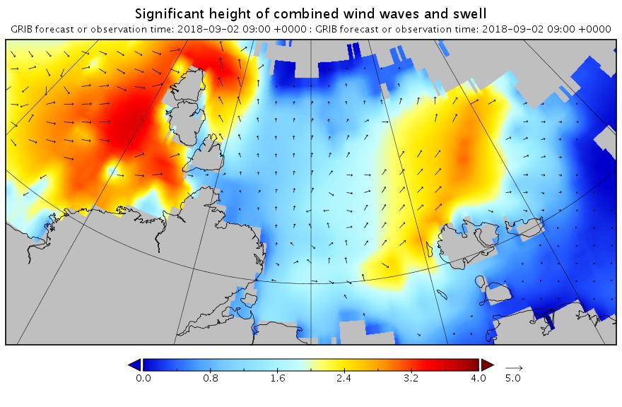
Here are the swell and period forecasts at midnight for round about now, 09:00 UTC:
Significant_height_of_combined_Laptev.20180902_00004

Mean_period_of_swell_waves_Laptev.20180902_00004

Significant_height_of_combined_Barents.20180902_00004

Mean_period_of_swell_waves_Barents.20180902_00004

All the seas between Greenland and the New Siberian Islands are awash with swells with a period of 8 second or greater. This is most unusual, to put it mildly!


[Edit – September 3rd]

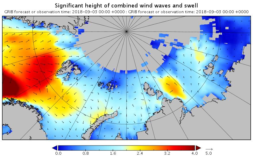
Here’s the WaveWatch III “hindcast” from midnight last night UTC for the Russian side of the Arctic Ocean:
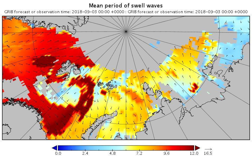
Significant_height_of_combined_NSR.20180903_00001

Mean_period_of_swell_waves_NSR.20180903_00001

There are still significant swells almost everywhere you look.


[Edit – September 4th]

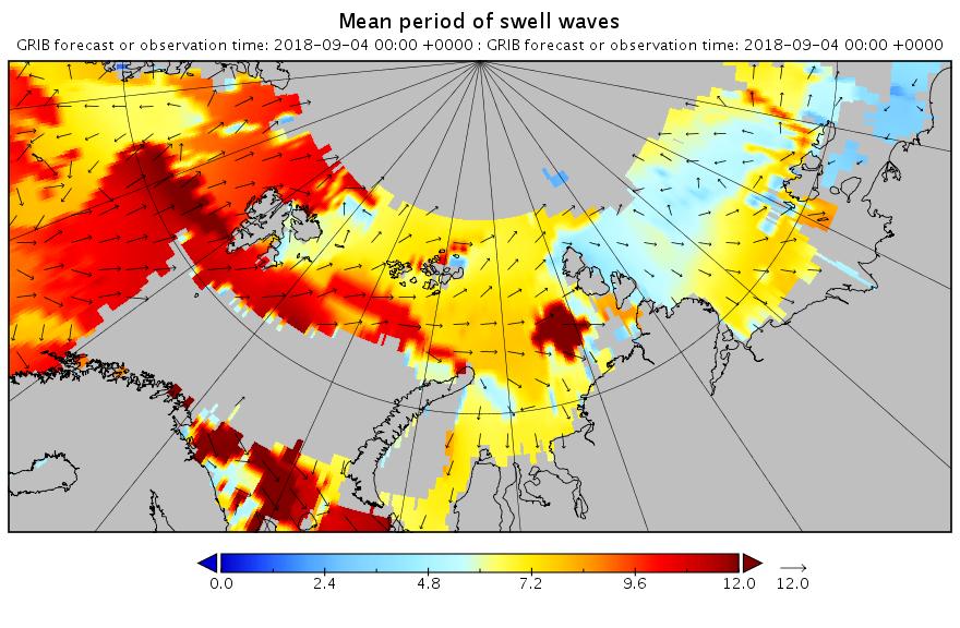
Using the same scales as yesterday, here’s today’s hindcast from midnight:
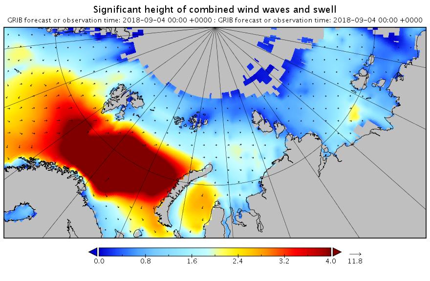
Significant_height_of_combined_w in multi_1.glo_30mext.20180904_00001

Mean_period_of_swell_waves_order in multi_1.glo_30mext.20180904_00001

There’s still plenty of action in the Arctic Ocean!


[Edit – September 5th]

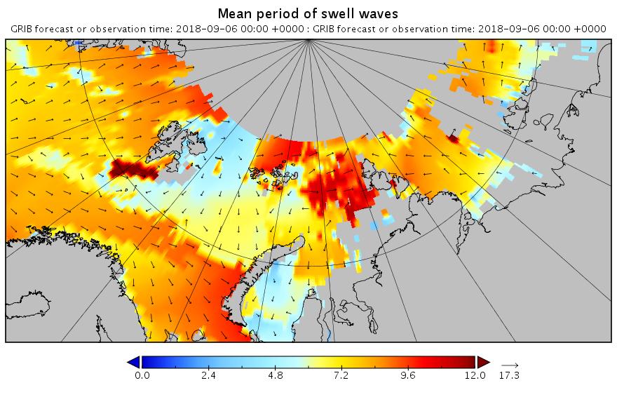
Feel free to debate whether it merits the “Great” prefix, but this is how the early September 2018 Arctic cyclone has panned out. According to this morning’s Environment Canada synopsis the cyclone is centred near the coast of the Laptev Sea and is down to a MSLP of 977 hPa:
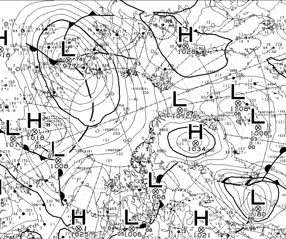
CMC_SLP-20180905-00Z

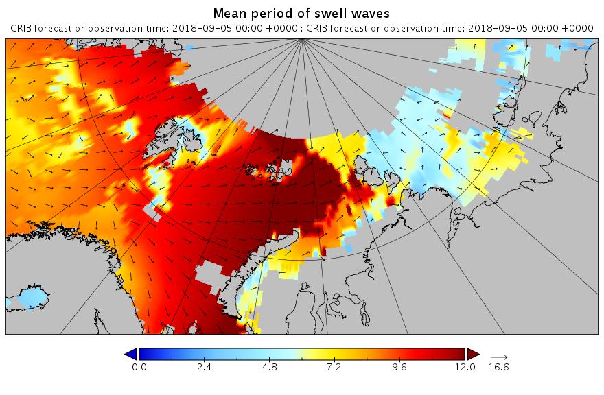
Here’s another WaveWatch III hindcast from midnight UTC:
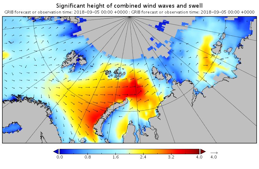
Significant_height_of_combined_w in multi_1.glo_30mext.20180905_00001

Mean_period_of_swell_waves_order in multi_1.glo_30mext.20180905_00001


[Edit – September 6th]

Need I say more?
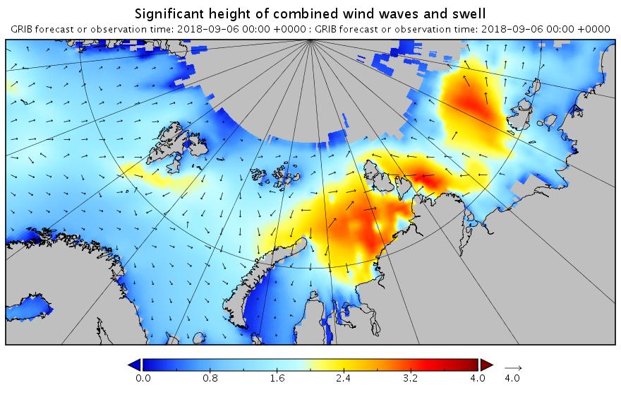
Significant_height_of_combined_NSR.20180906_00001

Mean_period_of_swell_waves_NSR.20180906_00001


[Edit – September 7th]

The swell in the Fram Strait an Barents Sea is diminishing, but the period in the Laptev Sea is increasing now:
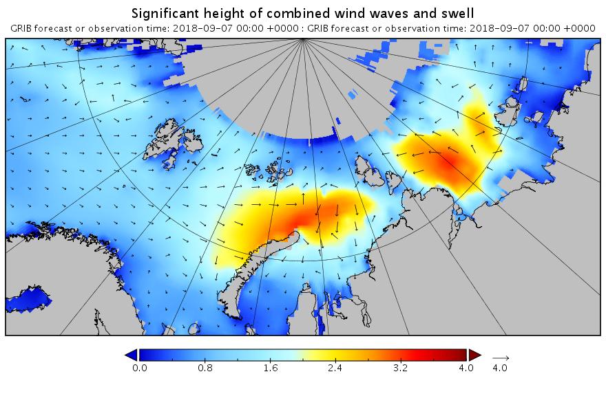
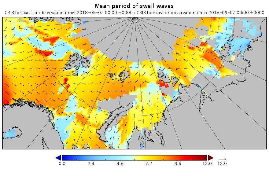
Significant_height_of_combined_NSR.20180907_00001

Mean_period_of_swell_waves_NSR.20180907_00001


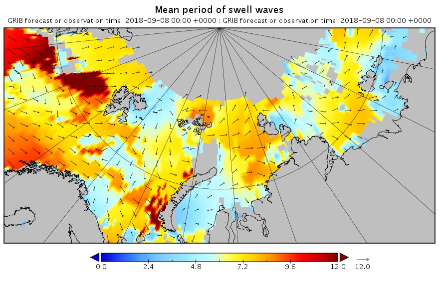
[Edit – September 8th]

All the wave activity in the Laptev Sea is diminishing. Here’s the hindcast from midnight:
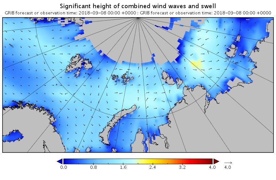
Significant_height_of_combined_NSR.20180908_00001

Mean_period_of_swell_waves_NSR.20180908_00001

Meanwhile things are warming up in the Chukchi and Beaufort Seas. Here’s the forecast for midnight tonight:
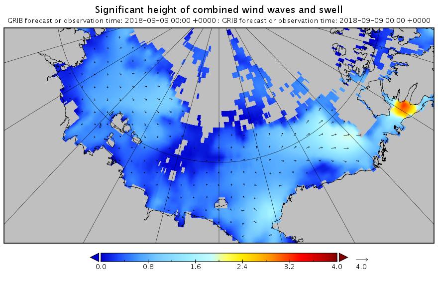
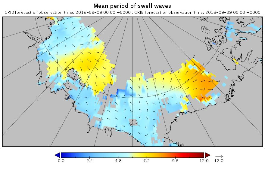
Significant_height_of_combined_Pacific.20180908_00009

Mean_period_of_swell_waves_Pacific.20180908_00009


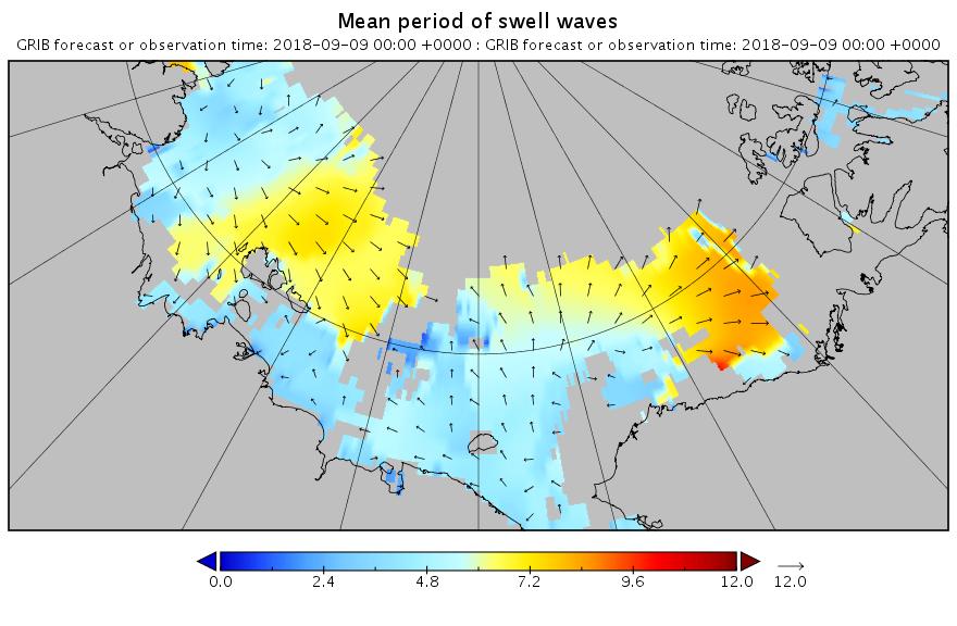
[Edit – September 9th]

Here’s the hindcast for this morning’s swell in the Beaufort Sea:
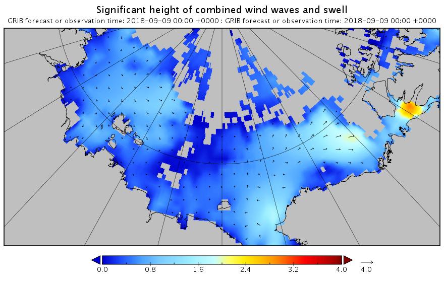
Significant_height_of_combined_Atlantic.20180909_00001

Mean_period_of_swell_waves_Pacific.20180909_00001

This is currently a long way into the future and hence may not verify in practice. However any pulse of swell is currently forecast for September 13th:
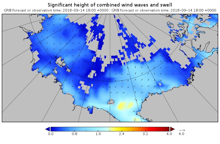
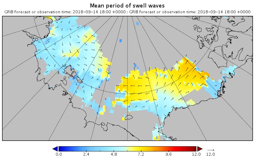
Significant_height_of_combined_Atlantic.20180909_00047

Mean_period_of_swell_waves_Pacific.20180909_00047

The 2016 Arctic Winter Sea Ice Puzzle

Professor Judith Curry recently posed the following rhetorical question on her “Climate Etc.” blog:

Arctic sea ice extent has been anomalously low this winter. The greatest anomalies are in the European sector, specifically in the Barents Sea. To what extent are the anomalies associated with warm temperatures?

Which she answered as follows:

So, what might be causing this particular anomaly? Some possibilities are:

  • Gobal warming (January 2016 was warmest Jan on record, according to the surface temperature analyses

  • Multidecadal oscillations (e.g. stadium wave) predicts ice recovery to be occurring in the same region (European Arctic) where we see the sea ice decline).

  • Seasonal weather circulation patterns – this has been a year with with unusual weather patterns, with both low temperature and high temperature records being set.

As regular readers will already be aware we have been blogging about anomalously warm temperatures in the Arctic all year and so felt well qualified to contribute to the “debate”. What a job that turned out to be! Early on in the proceedings the anticipated pronouncement was made by one of Judith’s “denizens”. A link to a ludicrously inaccurate article on Watts Up With That accompanied by the following words of wisdom:

Other measures are high.

Which of course they aren’t! Instead of stating the bleedin’ obvious Professor Curry replied:

I spotted this, no idea what to make of it.

You would think she and her denizens would therefore have been pleased when I attempted to explain to her what to make of it, but you would have been mistaken. The icing on the ad hominem cake was the aforementioned Anthony Watts driving by to accuse me of all sorts of nefarious activities without providing a single shred of evidence and then running for the hills when invited to actually prove his ludicrous allegations.

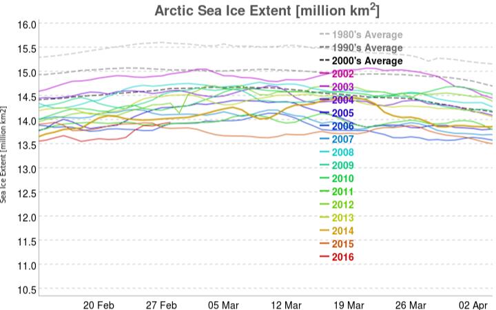
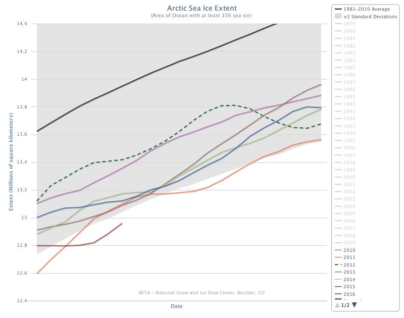
Since the denizens of “Climate Etc.” aren’t particularly interested let’s take stock here instead shall we? After every Arctic area and extent metric under the sun sitting at “lowest *ever” levels for weeks a recent increase in coverage on the Pacific side of the Arctic has changed that. The most up to date example of that is the JAXA/ADS extent, which currently looks like this:

vishop_extent-20160228

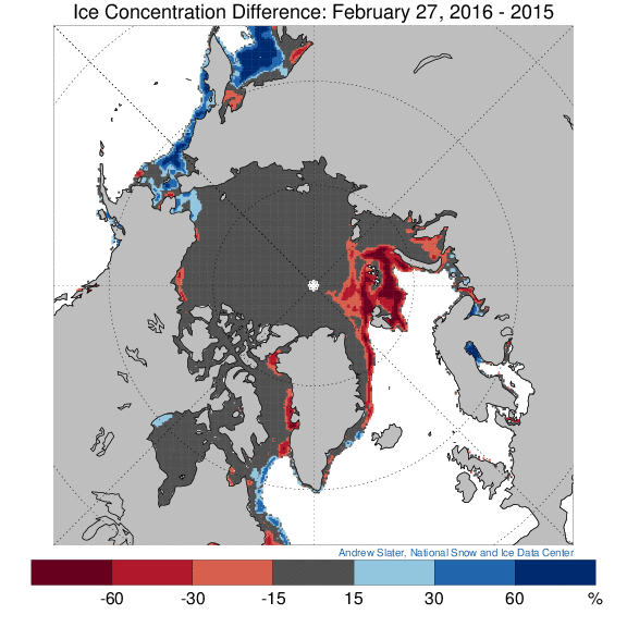
The latest reading is the merest whisker above 2015’s record low maximum. However in other respects things are most certainly not comparable with 2015. See for example this concentration comparison from Andrew Slater of the NSIDC:

ice_con_delt_20160227

Much more ice on the Pacific periphery where it will all have disappeared by September, as opposed to much less ice on the Atlantic side, even well to the north of 80 degrees latitude where the sun still does not shine. Here’s a video revealing how the sea ice North of the Pacific Ocean has been reacting to the sequence of hurricane force storms that have been passing through the area over the past couple of months:

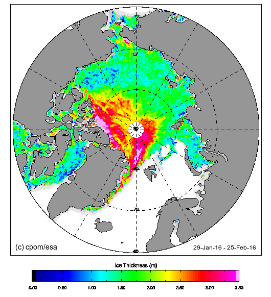
Now let’s take a look at “near real time” Arctic sea ice thickness as measured by the CryoSat 2 satellite:

CryoSat2_20160225

Notice the absence of any thick ice in the Beaufort and Chukchi Seas, an obvious difference from last year? Notice too the large area of thick ice that looks as though it’s heading towards the Fram strait exit from the Central Arctic. Here’s another video, this time of sea ice movement over on the Atlantic side of the Arctic Ocean:

Those dark areas between Svalbard and the North Pole are suddenly starting to look as though they represent reality rather than a mere “artifact”, although perhaps they are merely transient evidence of yet another Arctic “heat wave”?

New Year 2016 Arctic Meltdown Update

On January 1st 2016 the 15% concentration threshold daily Arctic sea ice extent metric reported by the United States National Snow and Ice Data Centre reached the lowest ever level for the first day of any year since their satellite derived records began in 1979. A couple of days later the more familiar 5 day trailing averaged extent also reached the lowest ever level for the date:

Charctic-20160107

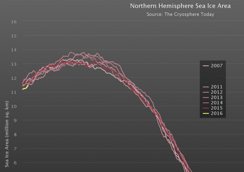
Cryosphere Today have been somewhat sluggish about updating their records of Arctic sea ice area, but have at long last revealed that their metric is now also at the lowest ever level for the date:

CT-NH-20160107

Meanwhile Great White Con commenter “Just A Thought” states that:

I find it hard, with what I do have access to, to see why everyone is so worried that the Arctic is melting.

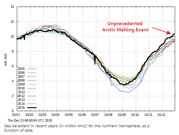
He or she has evidently only had access to the propaganda perpetrated by Tony Heller (AKA “Steve Goddard”) on his so called “Real Climate Science” blog. Mr. Heller’s latest Arctic pronouncement on December 31st 2015 is entitled “Arctic Meltdown Update” and claims that:

Experts say that a terrifying storm melted the North Pole yesterday. This unprecedented melting event has caused Arctic ice to reach its highest December extent in over a decade.

justifying that comment with the following graph of his beloved (albeit deprecated) 30% concentration threshold DMI extent metric:

DMI-30-2015-12-31-

Here’s a video revealing the effect of the recent “terrifying storm” on the sea ice on the North Atlantic side of the Arctic:

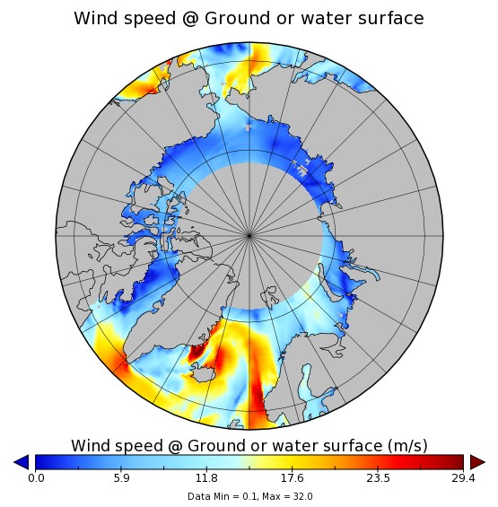
As you can see the ice at the North Pole didn’t melt away. However the ice edge did retreat in the immediate aftermath of what is referred to here in the United Kingdom as “Storm Frank“. Frank led to lots of flooding in the North of the nation, and also to some strong winds inside the Arctic Circle:

WW3Wind-20151230-1400

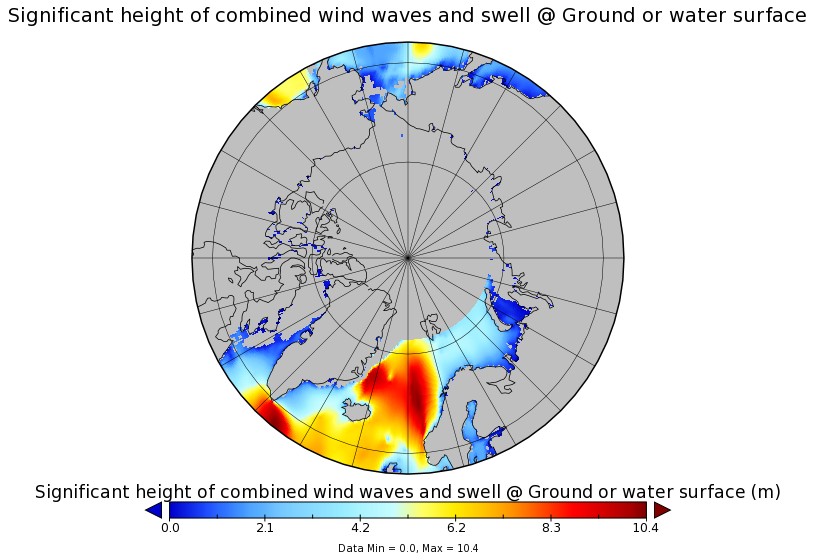
Those winds, travelling over a long stretch of open ocean, produced some pretty significant waves, speeding in the direction of the sea ice edge:

WWIII-20151231-0000

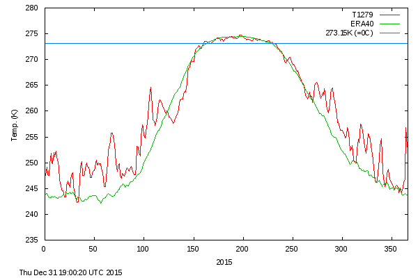
Meanwhile temperatures near the North Pole did briefly rise above the freezing point of sea ice in the middle of the Arctic winter. Here’s the Danish Meteorological Institute’s view of the air temperatures in the central Arctic:

meanT_20151231

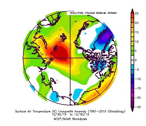
and here is NOAA’s temperature anomaly reanalysis for December 30th 2015:
NOAA-anomT_20151230

Personally I reckon the 25 m/s winds and resulting 10 meter waves had more effect on the sea ice metrics than the 25 °C above normal air temperatures, but your mileage may of course vary, especially if your pseudonym is “Steve Goddard”!