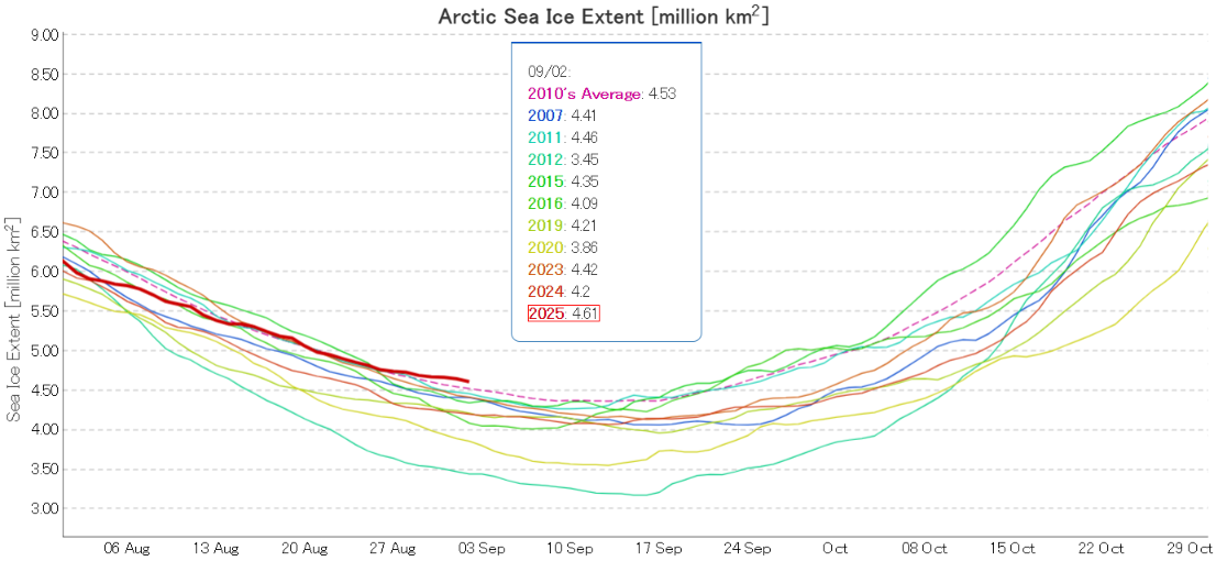
At the beginning of last month JAXA/ViSHOP extent was third lowest for the date in the satellite era. With the date of the 2025 minimum extent rapidly approaching that is no longer the case:
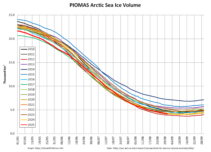
Whilst JAXA extent is now 10th lowest, PIOMAS volume remains second lowest for the date:
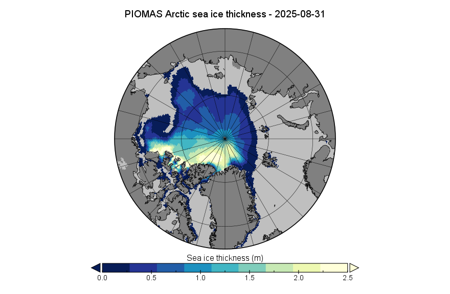
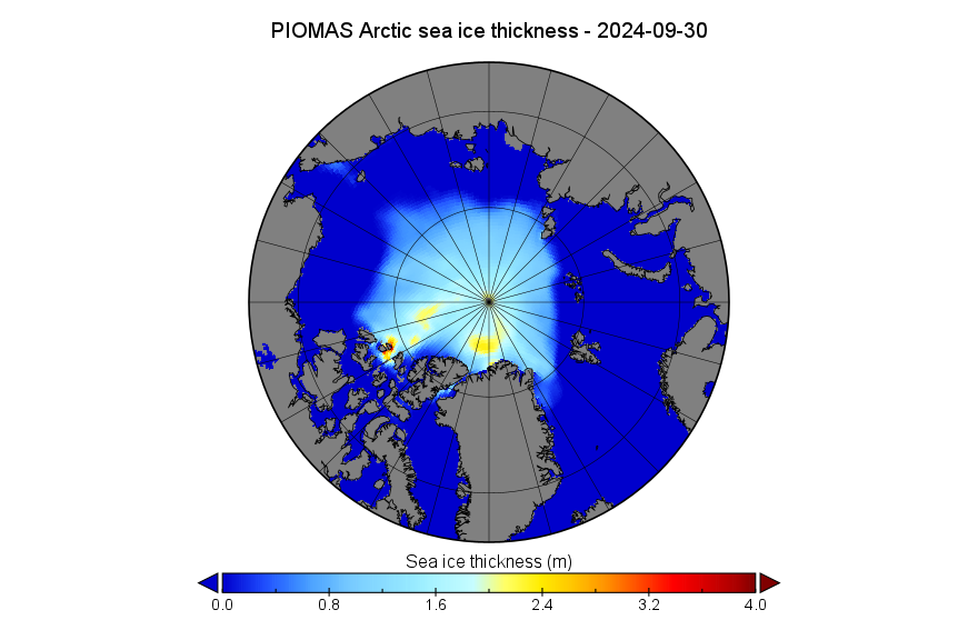
Here’s the associated thickness map. Note the change of scale from last month
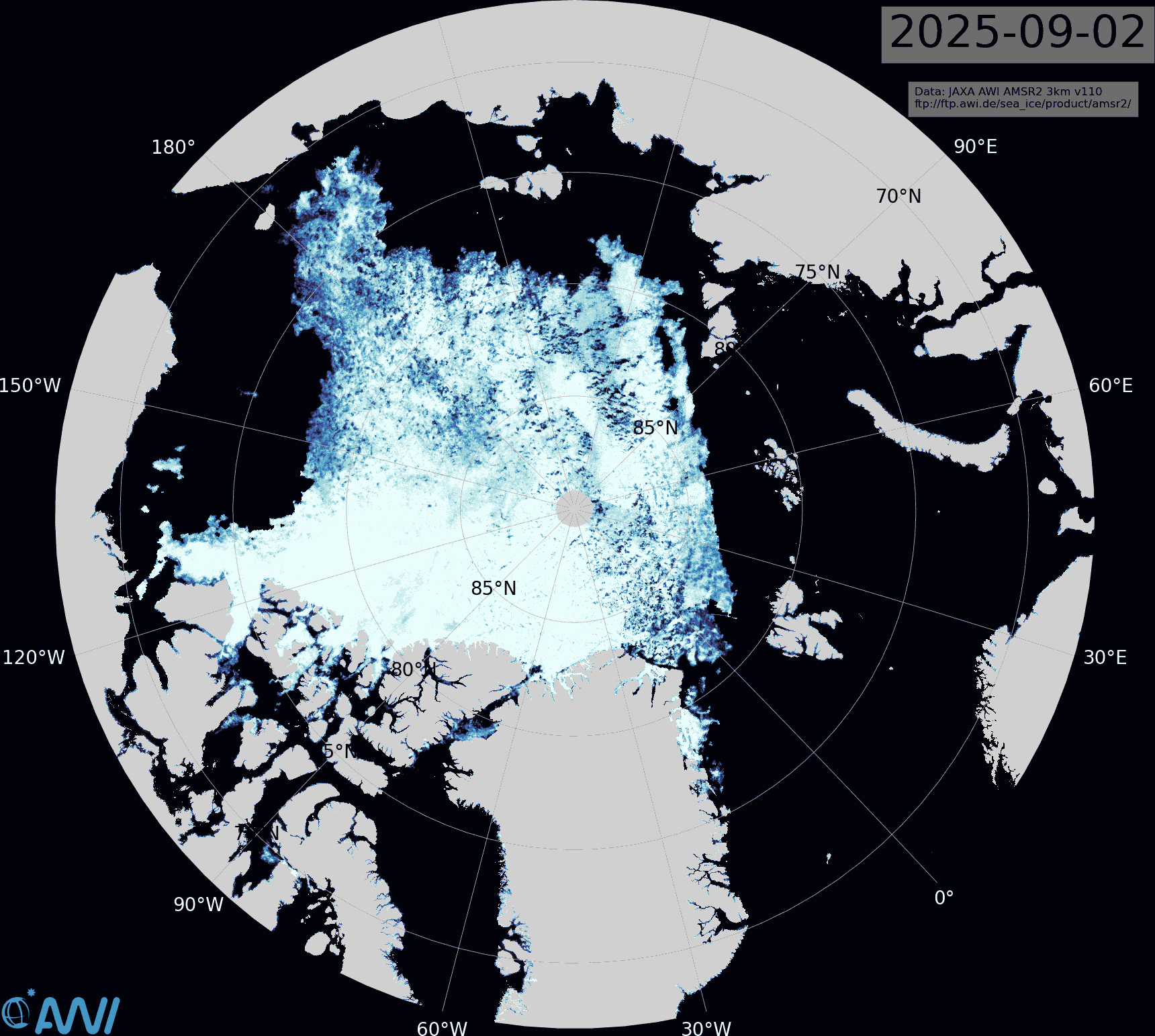
Compare and contrast that map with the AWI’s sea ice concentration map, particularly in the Beaufort Sea area:
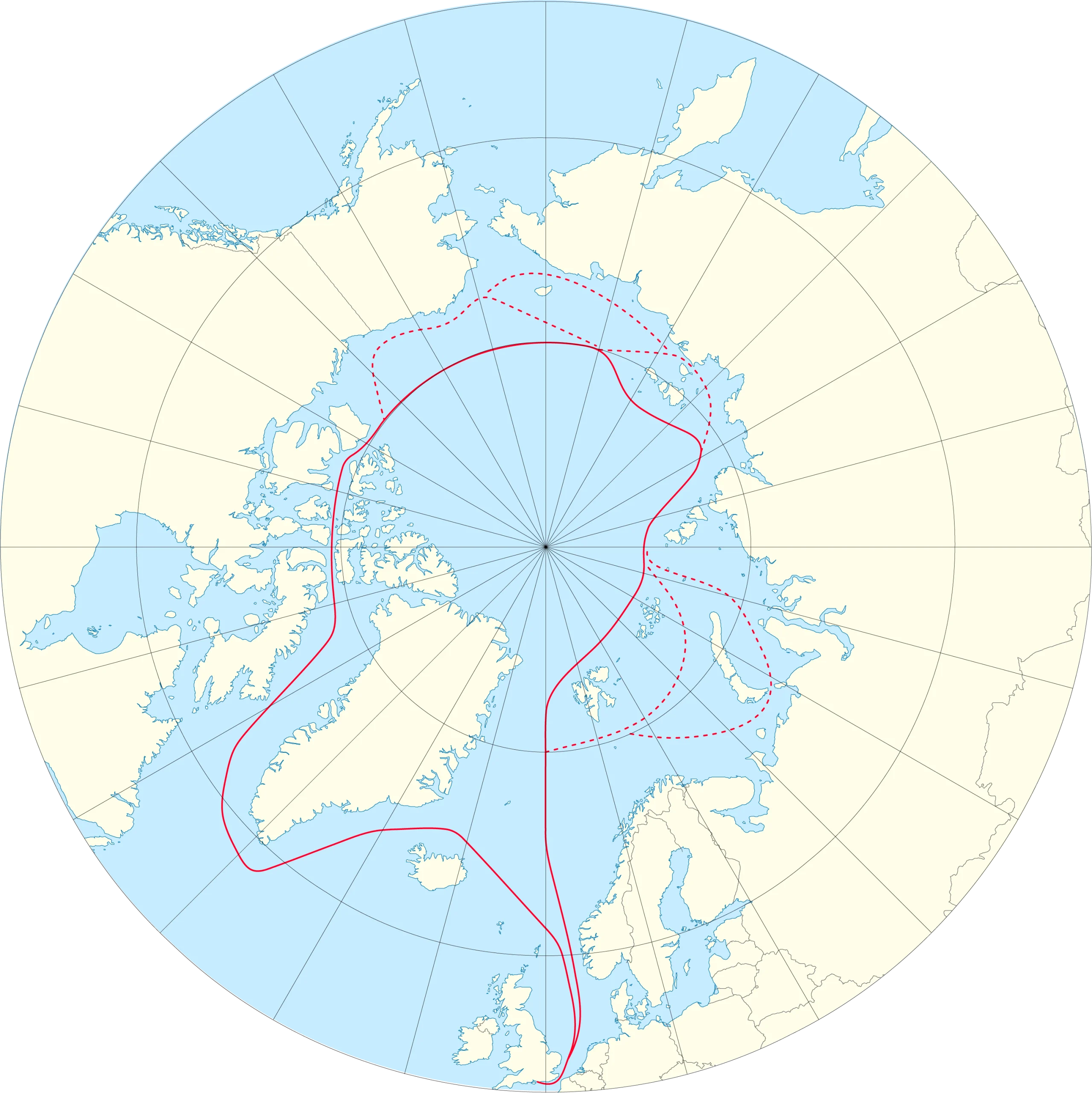
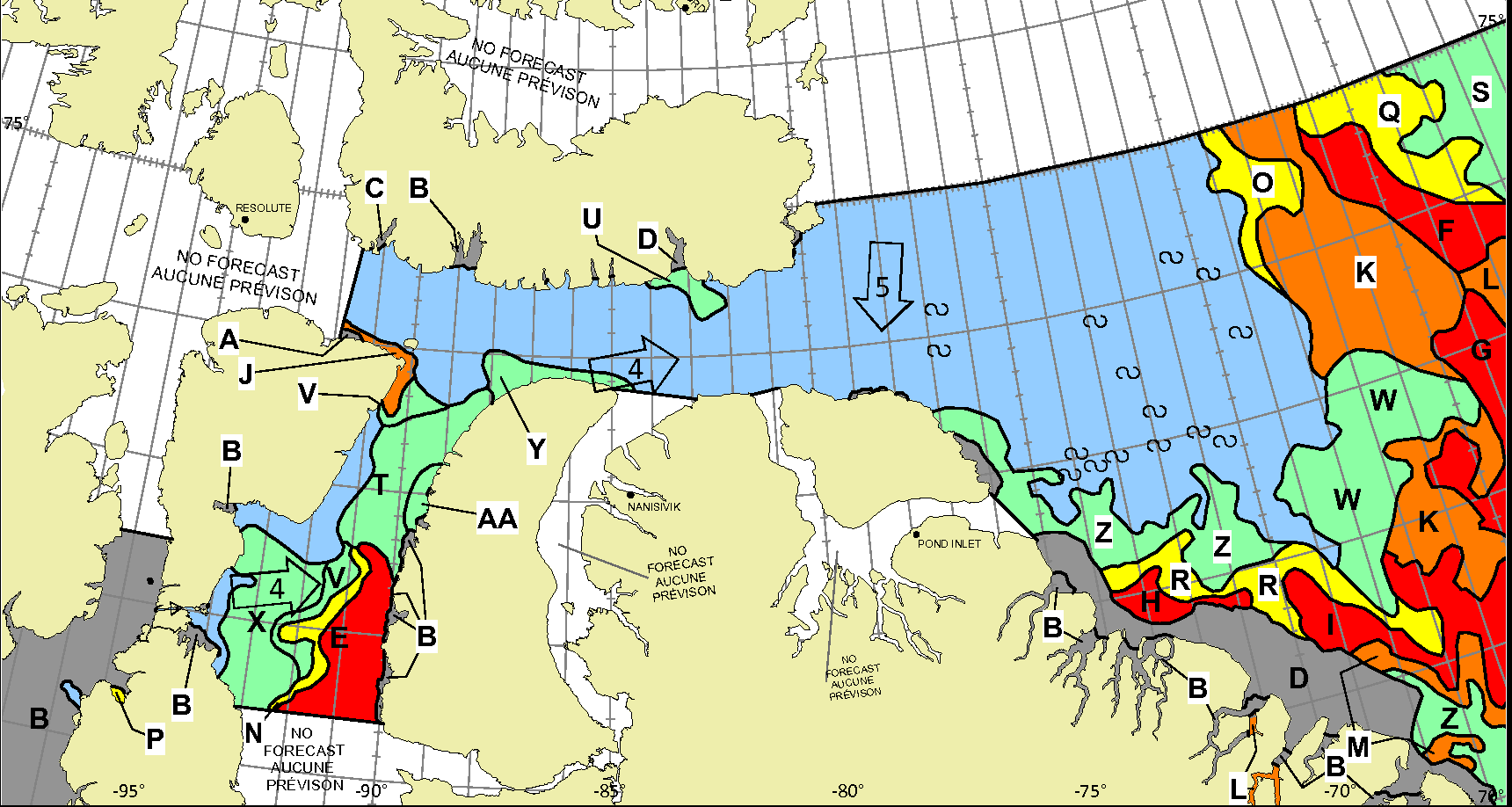
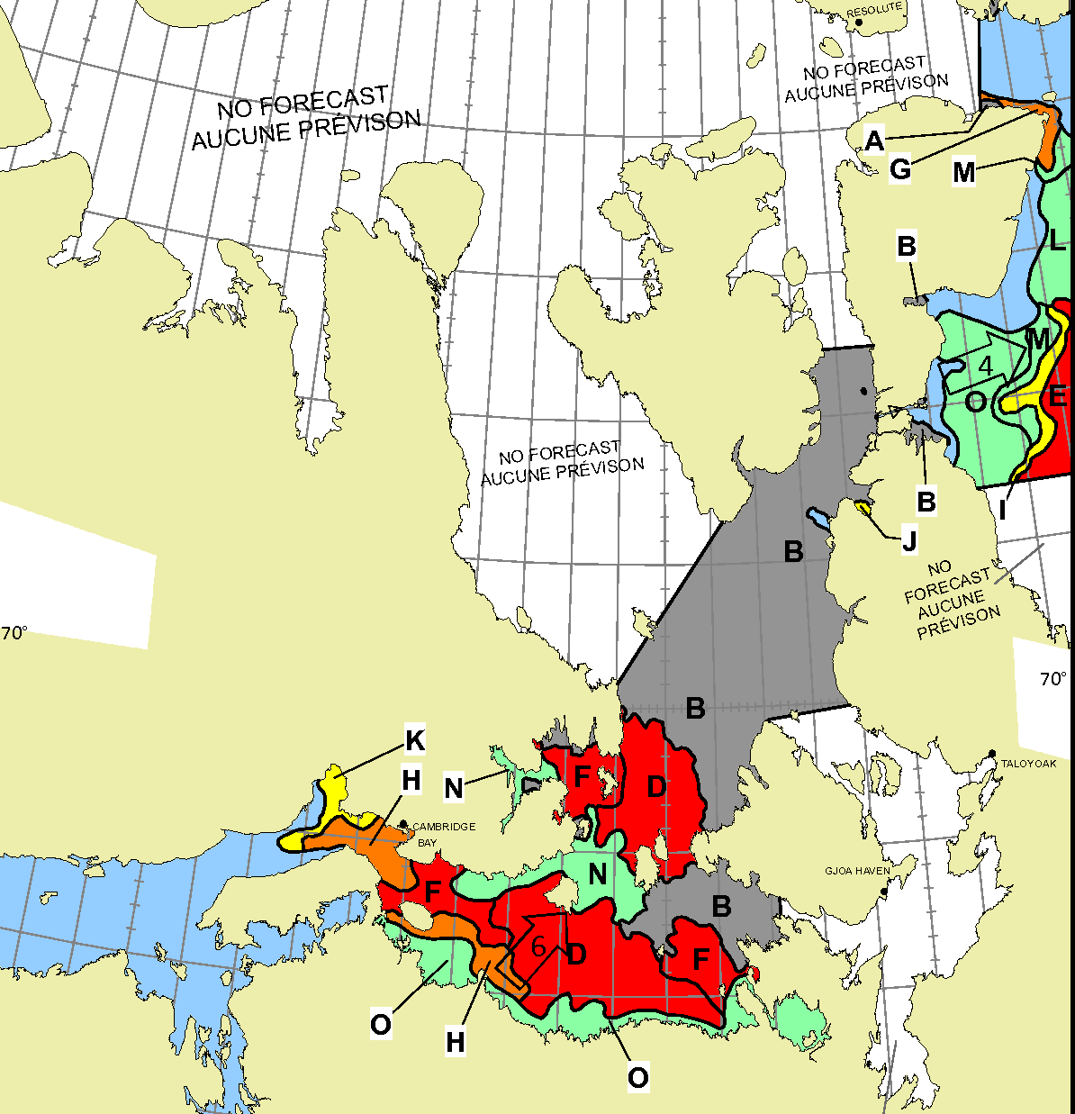
I’m opening the 2025 Northwest Passage thread earlier than usual, because of some news you can read if you scroll down. However, let’s first of all get our bearings with the help of this map of the area:
and another map detailing the routes through Canadian Arctic Archipelago that have previously been successfully traversed:
The news I was referring to is that at lunchtime today Ella Hibbert is setting off in her yacht Yeva from Haslar Marina near Portsmouth in southern England for a rather unusual voyage through the Northwest Passage this summer. Here is Ella’s current route plan:
You will note some unusual features. Apparently Ella is intent on taking Route 1 into the Beaufort Sea via McClure Strait. After that she is not heading for the Bering Strait, but is instead taking the route less travelled back to Haslar via the Northern Sea Route. Perhaps even more surprising in this day and age is that Ella has received permission to sail through Russian waters without an ice pilot. She is aiming to complete an entire circumnavigation of the Arctic in a single summer single handed! As Ella puts it, this is “A voyage that should not be possible”:
Ella is hoping to overcome terrifying challenges including icebergs, freezing water and polar bears.
Her journey – which has only recently become possible due to melting polar ice caps – aims to showcase the devastating environmental impact of sea ice decline, both in the Arctic and across the world.
Ella’s voyage also aims to support two charities working tirelessly to protect the Arctic: Polar Bears International and the Ocean Conservancy.
At the end of her voyage, Ella will auction her ship Yeva with proceeds to go to these two charities.
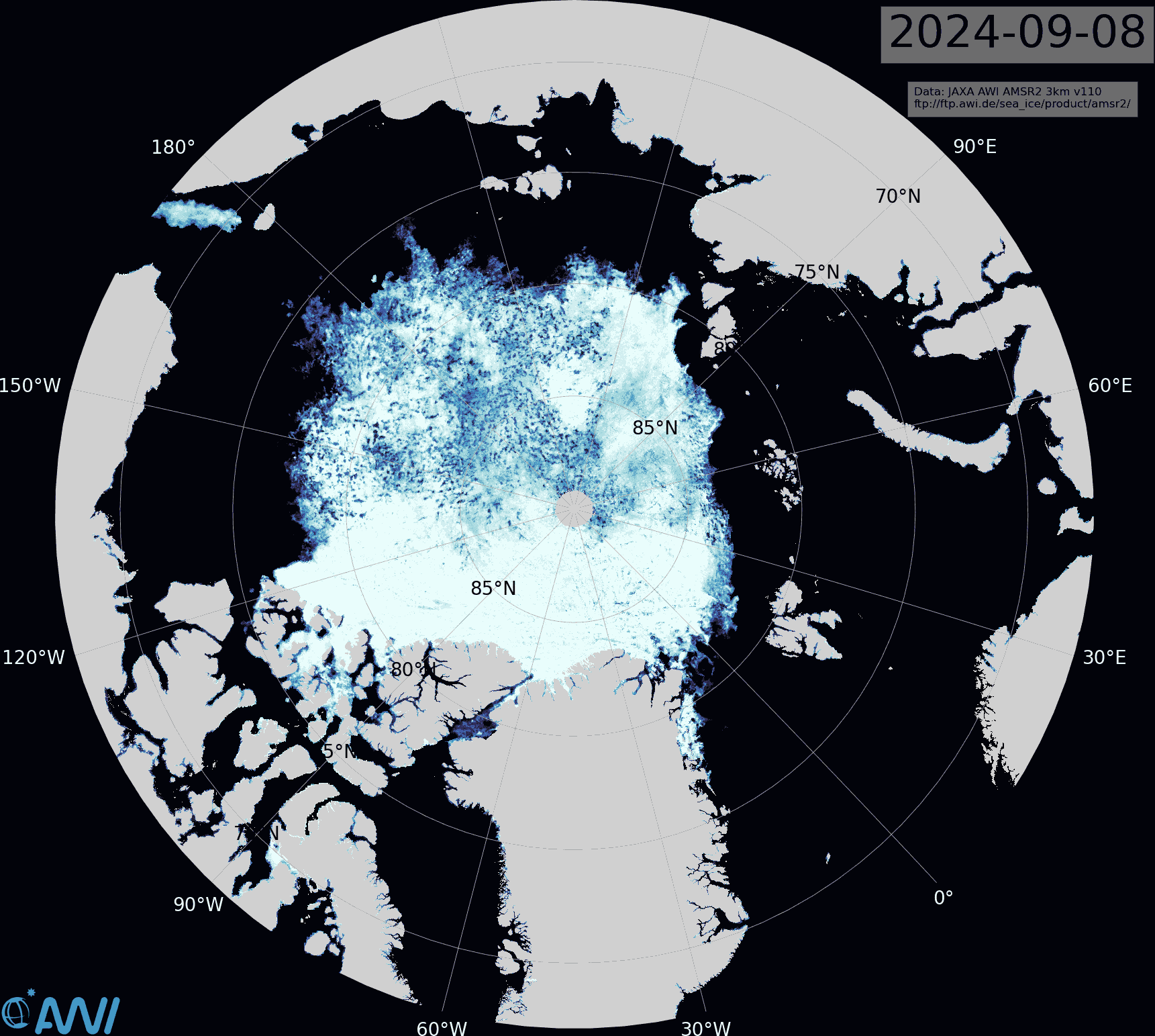
The JAXA extent graph is currently not updating, so let’s begin this month with the latest AMSR2 sea ice concentration map from the Alfred Wegener Institute. Click the image to see a ~10 Mb animation of the last four weeks:
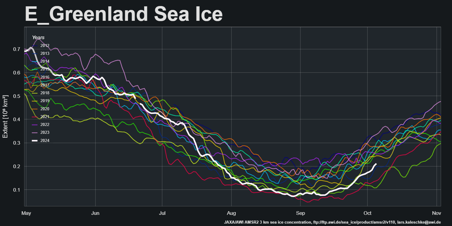
Note in particular the restart of export into the East Greenland Sea via the Fram Strait:
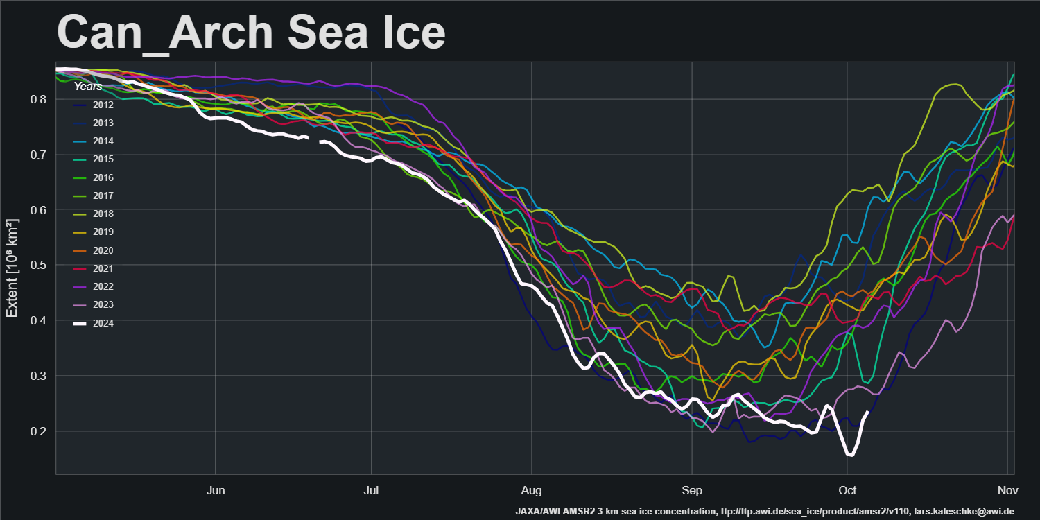
and the movement of ice within the Canadian Arctic Archipelago:
The PIOMAS gridded thickness data for September 2024 has been released:
Some “pleasure craft” are currently heading up the west coast of Greenland en route to the Bering Strait via Lancaster Sound and one of the assorted routes through the Canadian Arctic Archipelago. For those of you unfamiliar with the geography of the Northwest Passage, here are couple of hopefully helpful maps:
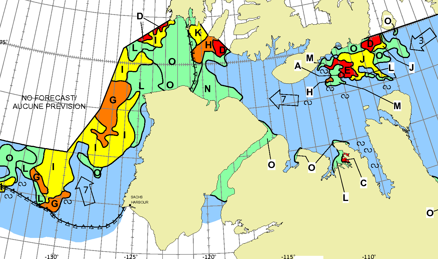
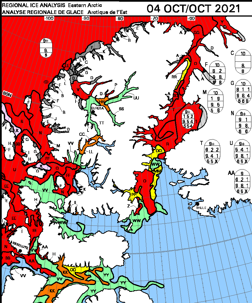
Whilst there is still ice blocking the route across Baffin Bay from Greenland, the Canadian Ice Service has already started daily coverage of the heart of the southern route through the Northwest Passage. There’s plenty of open water in Lancaster Sound and low concentration sea ice in Prince Regent Inlet:
Further south there is also open water in the Coronation Gulf, but the fast ice between Peel Sound and King William Island has not yet started breaking up:
This slightly cloudy satellite image of the Canadian Arctic Archipelago also shows that the exit of the northern route via McClure Strait into the Beaufort Sea is already navigable:
The 2023 Arctic Report Card has been published by the US National Oceanic and Atmospheric Administration (NOAA). All sorts of things are discussed in the report, but sticking to Snow White’s speciality of sea ice here’s an extract:
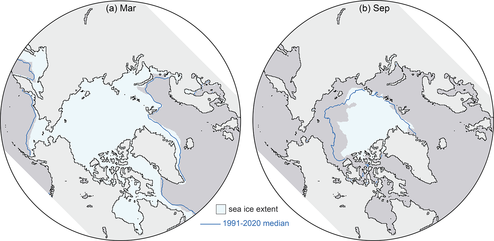
This satellite record tracks long-term trends, variability, and seasonal changes from the annual extent maximum in late February or March and the annual extent minimum in September. Extents in recent years are ~50% lower than values in the 1980s. In 2023, March and September extents were lower than other recent years, and though not a new record low, they continue the long-term downward trends:
March 2023 was marked by low sea ice extent around most of the perimeter of the sea ice edge, with the exception of the East Greenland Sea where extent was near normal. At the beginning of the melt season, ice retreat was initially fairly slow through April. In May and June, retreat increased to a near-average rate, and then accelerated further through July and August. By mid-July, the ice had retreated from much of the Alaskan and eastern Siberian coast and Hudson Bay had nearly melted out completely. In August, sea ice retreat was particularly pronounced on the Pacific side, opening up vast areas of the Beaufort, Chukchi, and East Siberian Seas. Summer extent remained closer to average on the Atlantic side, in the Laptev, Kara, and Barents Seas
The Northern Sea Route, along the northern Russian coast, was relatively slow to open as sea ice extended to the coast in the eastern Kara Sea and the East Siberian Sea, but by late August, open water was found along the coast through the entire route. The Northwest Passage through the Canadian Archipelago became relatively clear of ice, though ice continued to largely block the western end of the northern route through M’Clure Strait through the melt season. Nonetheless, summer 2023 extent in the Passage was among the lowest observed in the satellite record, based on Canadian Ice Service ice charts.
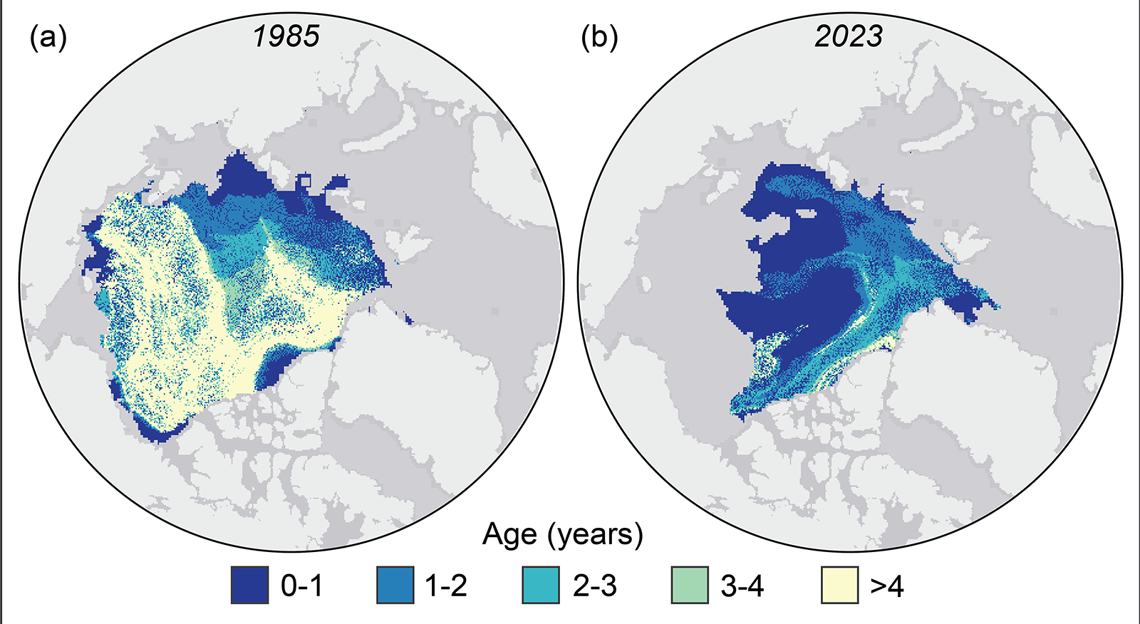
Tracking the motion of ice in passive microwave imagery using feature tracking algorithms can be used to infer sea ice age. Age is a proxy for ice thickness because multiyear ice generally grows thicker through successive winter periods. Multiyear ice extent has shown interannual oscillations but no clear trend since 2007, reflecting variability in the summer sea ice melt and export out of the Arctic. After a year when substantial multiyear ice is lost, a much larger area of first-year ice generally takes its place. Some of this first-year ice can persist through the following summer, contributing to the replenishment of the multiyear ice extent:
However, old ice (here defined as >4 years old) has remained consistently low since 2012. Thus, unlike in earlier decades, multiyear ice does not remain in the Arctic for many years. At the end of the summer 2023 melt season, multiyear ice extent was similar to 2022 values, far below multiyear extents in the 1980s and 1990s:
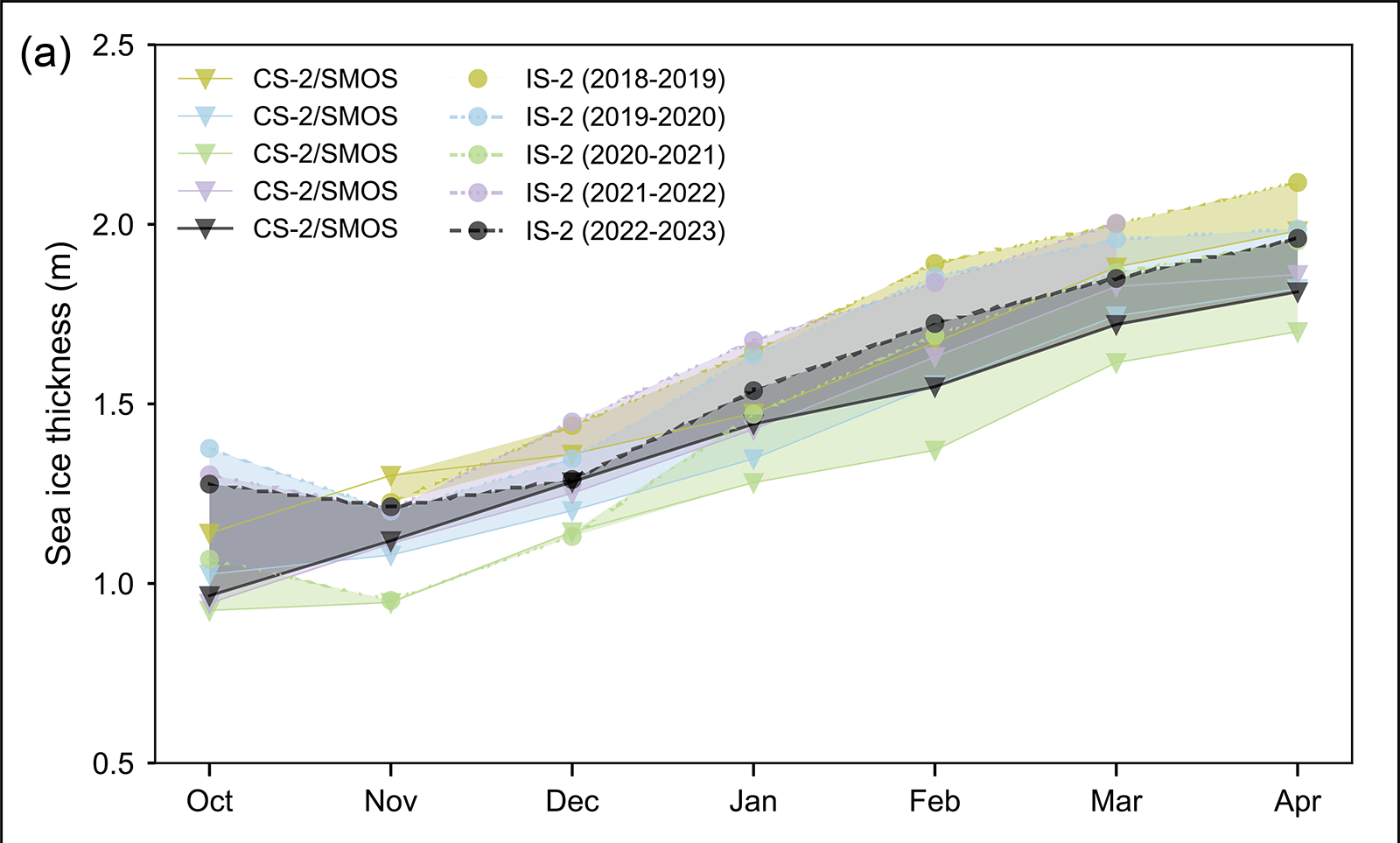
Estimates of sea ice thickness from satellite altimetry can be used to more directly track this important metric of sea ice conditions, although the data record is shorter than for extent and ice age. Data from ICESat-2 and CryoSat-2/SMOS satellite products tracking the seasonal October to April winter ice growth over the past four years (when all missions have been in operation) show a mean thickness generally thinner than the 2021/22 winter but with seasonal growth typical of recent winters:
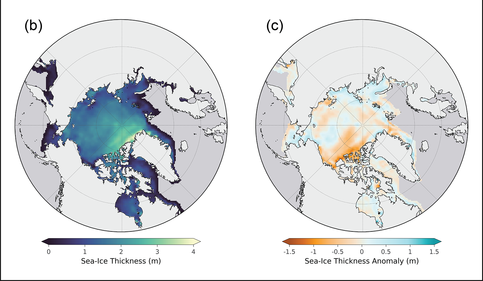
April 2023 thickness from CryoSat-2/SMOS relative to the 2011-22 April mean shows that the eastern Beaufort Sea and the East Siberian Sea had relatively thinner sea ice than the 2011-22 mean, particularly near the Canadian Archipelago. Thickness was higher than average in much of the Laptev and Kara Seas and along the west and northwest coast of Alaska, extending northward toward the pole. The East Greenland Sea had a mixture of thicker and thinner than average ice:
An excellent analysis (IMHO!), but I do have one quibble. I was following events in the Northwest Passage very closely last summer, and according to the Canadian Ice Service on September 1st:
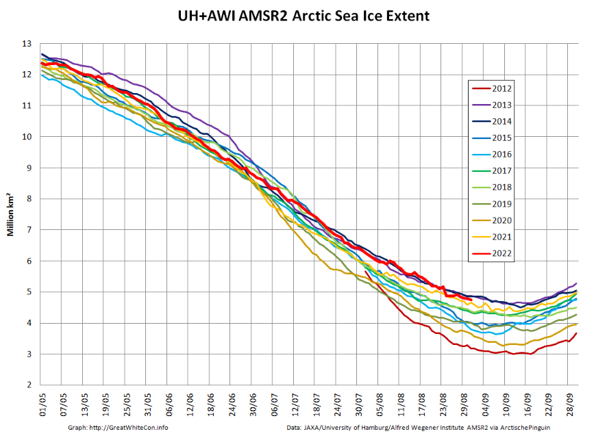
As in previous years there is already a thread devoted to this year’s minimum extent. By way of a summary here are the end of August numbers for our favourite “high resolution” AMSR2 area and extent metrics:
Extent is currently near the top of the range of the last 10 years.
We have now reached the stage of the “melting season” when “refreezing” has started in the Central Arctic but melting at the periphery is outpacing it. However the Canadian Ice Service stage of development charts now show the arrival of new ice in the high latitudes of the Canadian Arctic Archipelago:
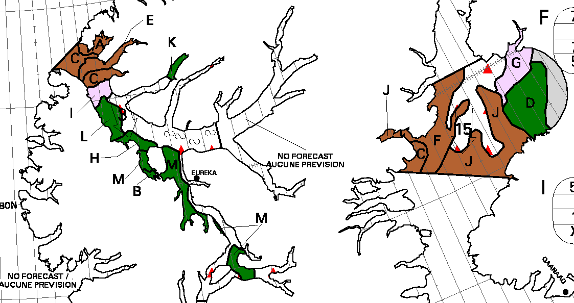
After a quiet couple of years due to the Covid-19 pandemic there are numerous cruises through the Northwest Passage planned for the summer of 2022. Some (very!) small vessels are also currently scheduled to attempt that perilous journey. First of all let’s take a look at a map of the assorted routes through the Canadian Arctic Archipelago:
plus another map which includes a few more place names:
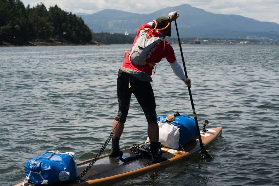
Next comes news of the expeditions planned by a variety of intrepid adventurers. According to Karl Kruger’s web site :
In 2022, Karl will attempt to become the first human to paddle 1,900 miles of the Northwest Passage on a standup paddleboard.
The article at the link is undated, but suggests that Karl initially intended to set off for Pond Inlet from Tuktoyaktuk in July 2019, but postponed the trip until the summer of 2020. By then Covid restrictions were in place, so next month provides the first opportunity for him to attempt the journey once again.
We’ve been following the voyage of the Canadian icebreaker CCGS Amundsen as he circumnavigated Banks Island. Now Amundsen is about to set off on the final leg of his 2021 Arctic campaign to conduct the “DarkEdge” study in northern Baffin Bay. According to the Amundsen Science web site:
7 October to 3 November – Cambridge Bay to Quebec City
During the final Leg of the 2021 Expedition, an integrated study (DarkEdge) will take place at the ice edge to study the key processes taking place during the fall-winter transition in northern Baffin Bay. The Sentinel North program will deploy an Autonomous Underwater Vehicle (AUV) and contribute to the Dark Edge campaign. The CCGS Amundsen will sail to Quebec City for the end of the annual expedition on November 3rd.
and according to Christian Katlein from the Alfred Wegener Institute:
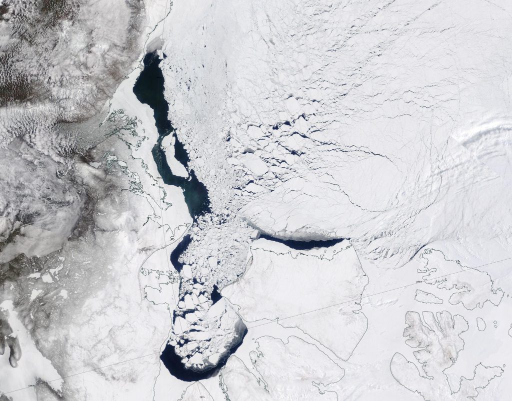
The Canadian Ice Service daily charts don’t currently cover the north of Baffin Bay, so here’s the most recent weekly which provides some idea of what Amundsen will be facing over the next few weeks:
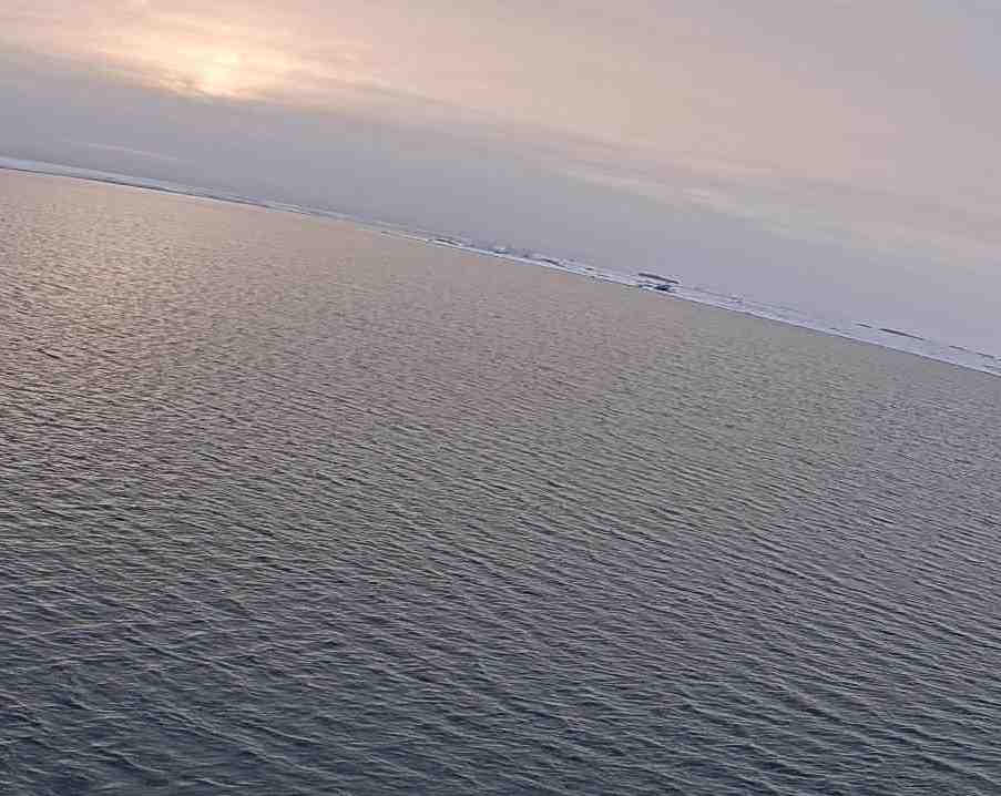
As Amundsen prepares to begin his voyage to the DarkEdge, here’s a watery sun setting over Cambridge Bay last night:
[Edit – October 11th]
Here’s the eighth video in Christian’s Sea Ice Stories series and the first from Amundsen itself, whilst moored in Cambridge Bay:
[Edit – October 12th]
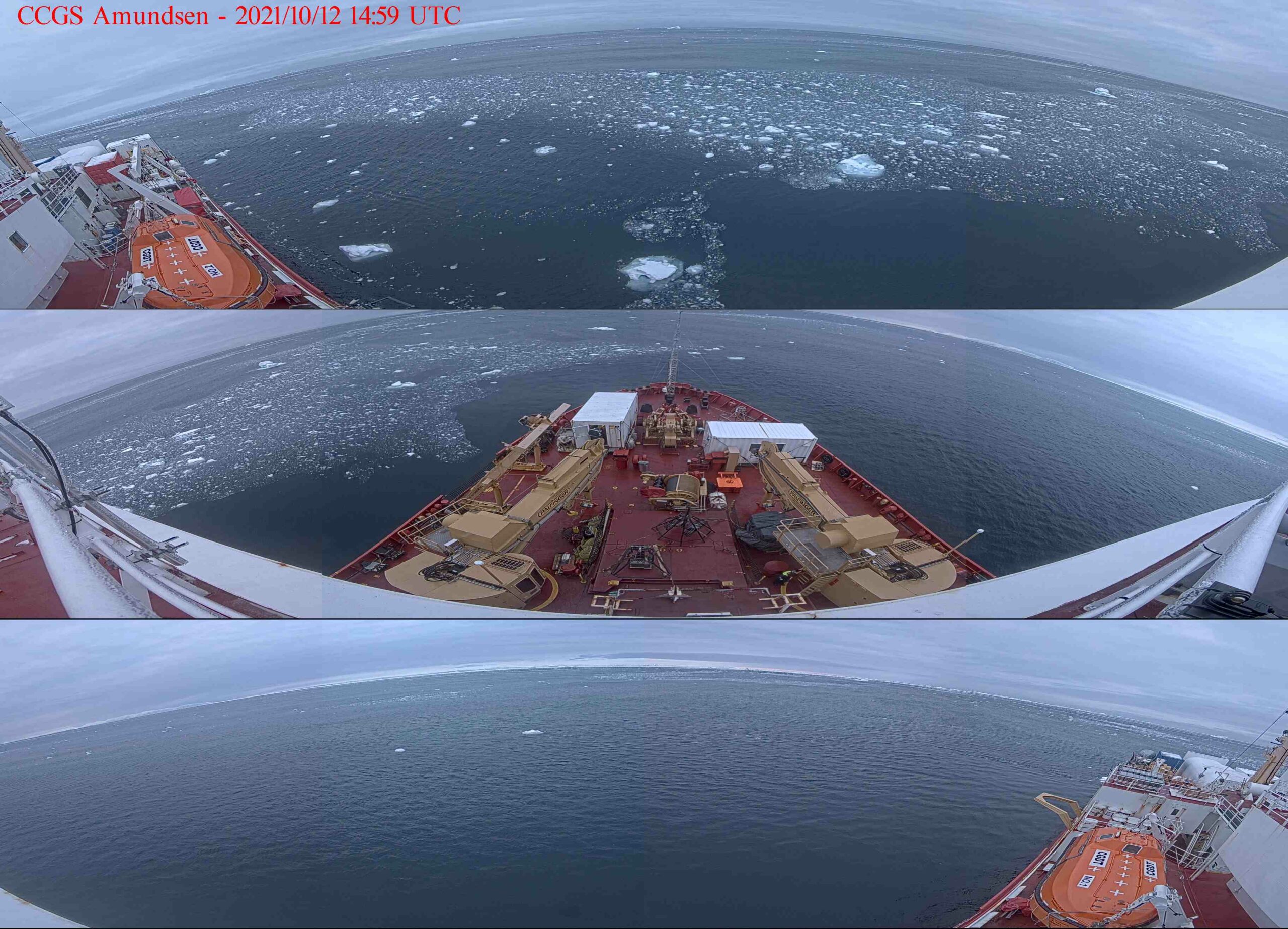
Amundsen has finally located a smidgen of sea ice in Baffin Bay, at approximately 76.10 N, 77.10 W. Click to enlarge:
[Edit – October 13th]
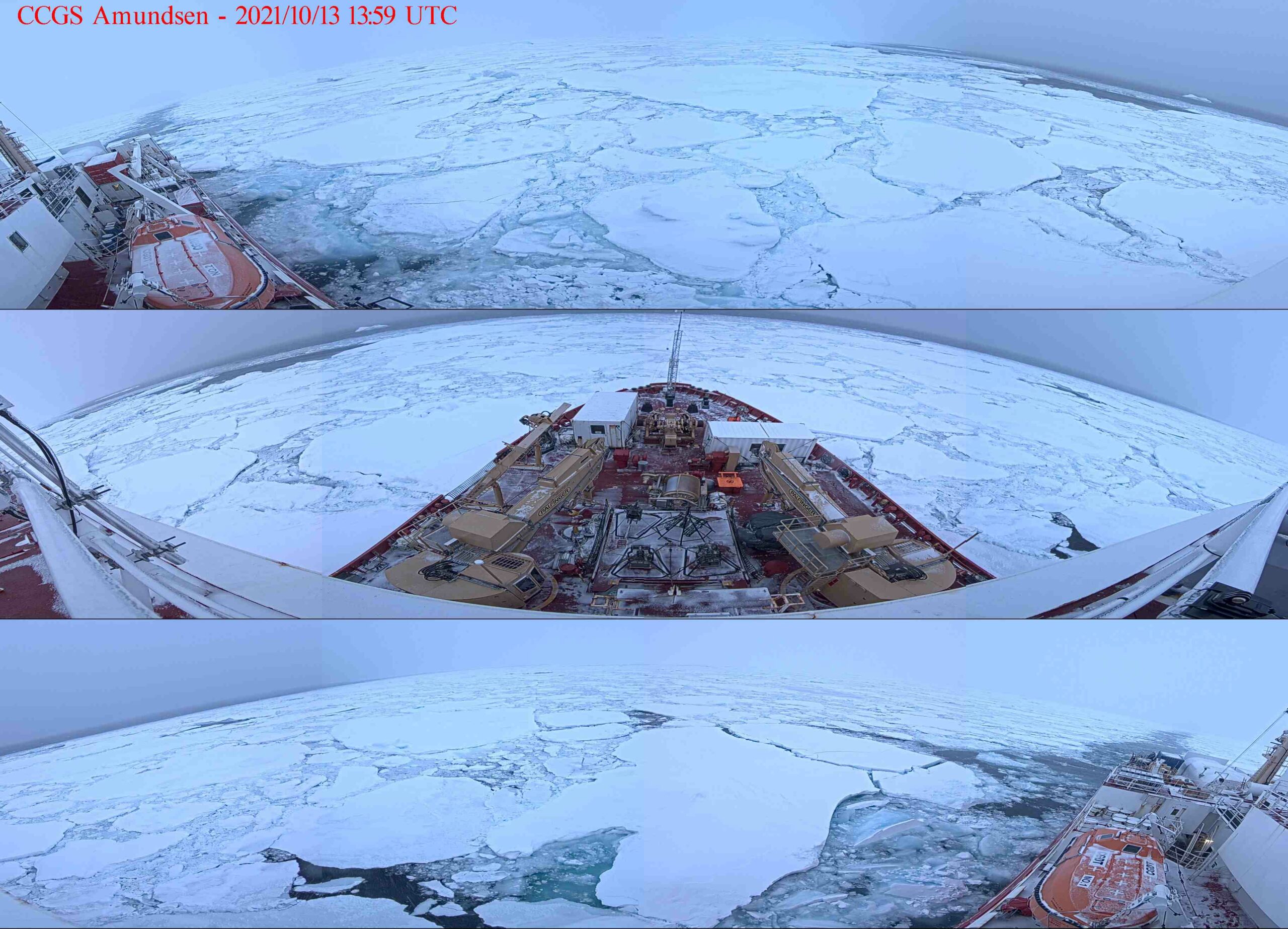
Amundsen has managed to find some more significant sea ice, this time located at around 76.30 N, 78.70 W:
Prompted by a comment on the Northwest Passage thread from last year I’m opening the 2021 equivalent earlier than usual, in part because there’s already a lot going on of interest. First of all let’s get our bearings with the help of this map of the area:
and another map detailing the routes through Canadian Arctic Archipelago that have previously been successfully traversed:
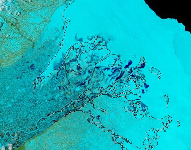
The forecast high pressure has arrived and the skies have cleared over the Beaufort Sea, which reveals that the land-fast ice off the Mackenzie Delta has started breaking up:
In addition the snow has been melting along the valley of the Mackenzie River, and the resulting increased flow at the mouth of the delta is flooding the fast ice:
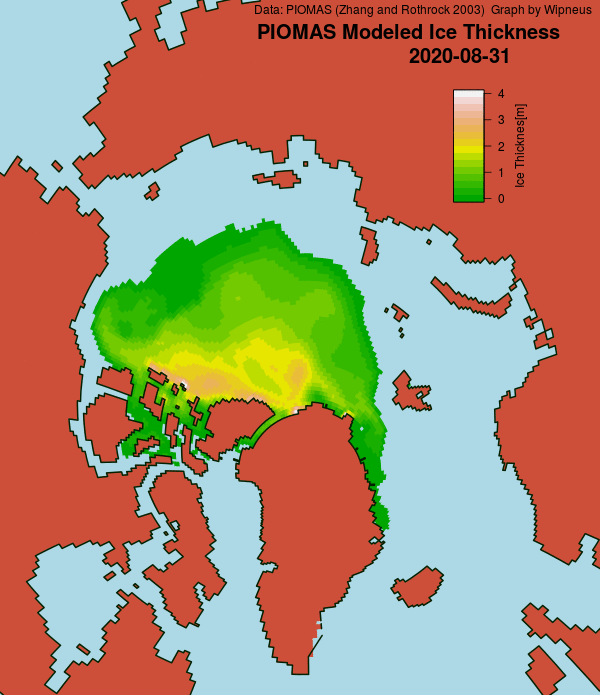
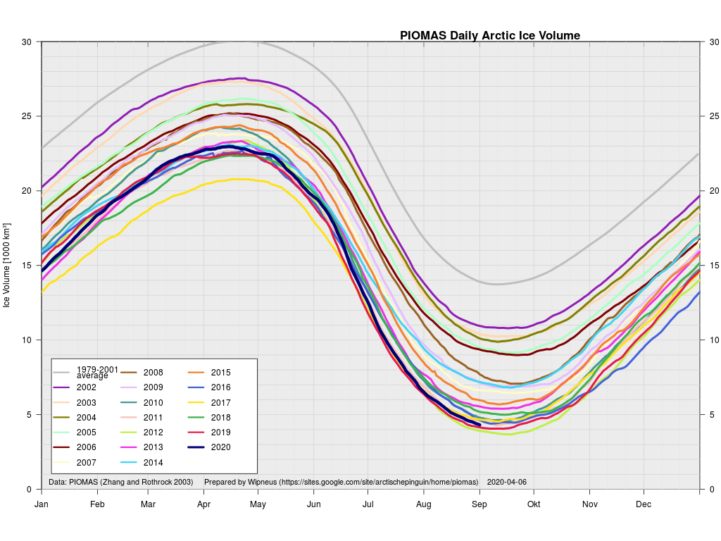
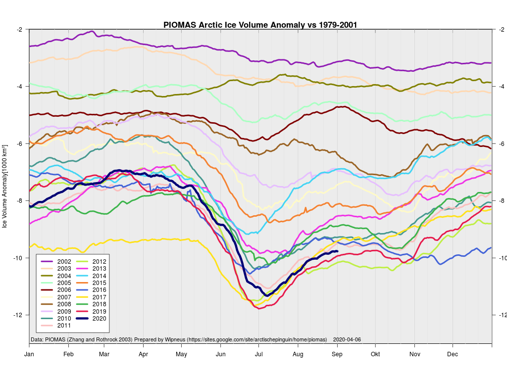
A detailed dissection of the 2020 minimum of various Arctic sea ice extent metrics can be found on a dedicated thread. All other Arctic news in September will be found below. As is usually the case, let’s set the ball rolling by taking a look at Wipneus’s visualisations of the August PIOMAS gridded thickness data:
together with the computed volume:
and anomaly graphs:
PIOMAS volume at the end of August was still firmly in 3rd place behind 2012 and 2019.
This website uses cookies to improve your experience. We'll assume you're ok with this, but you can opt-out if you wish. Cookie settingsACCEPT
Privacy & Cookies Policy
Privacy Overview
This website uses cookies to improve your experience while you navigate through the website. Out of these, the cookies that are categorized as necessary are stored on your browser as they are essential for the working of basic functionalities of the website. We also use third-party cookies that help us analyze and understand how you use this website. These cookies will be stored in your browser only with your consent. You also have the option to opt-out of these cookies. But opting out of some of these cookies may affect your browsing experience.
Necessary cookies are absolutely essential for the website to function properly. This category only includes cookies that ensures basic functionalities and security features of the website. These cookies do not store any personal information.
Any cookies that may not be particularly necessary for the website to function and is used specifically to collect user personal data via analytics, ads, other embedded contents are termed as non-necessary cookies. It is mandatory to procure user consent prior to running these cookies on your website.