Tag Archives: AMSR2

The Northwest Passage in 2021

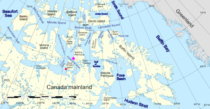
Prompted by a comment on the Northwest Passage thread from last year I’m opening the 2021 equivalent earlier than usual, in part because there’s already a lot going on of interest. First of all let’s get our bearings with the help of this map of the area:

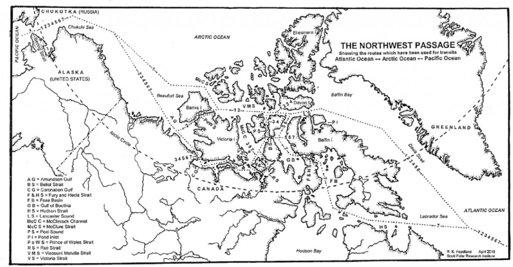
and another map detailing the routes through Canadian Arctic Archipelago that have previously been successfully traversed:

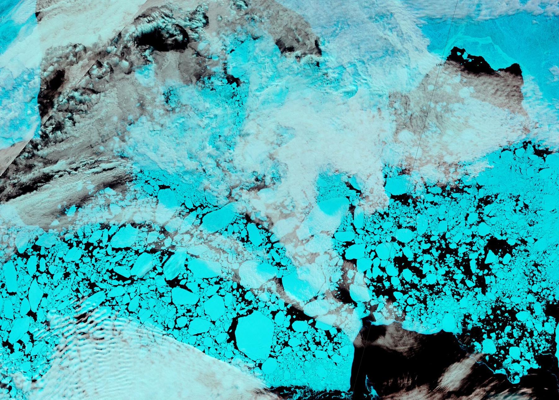
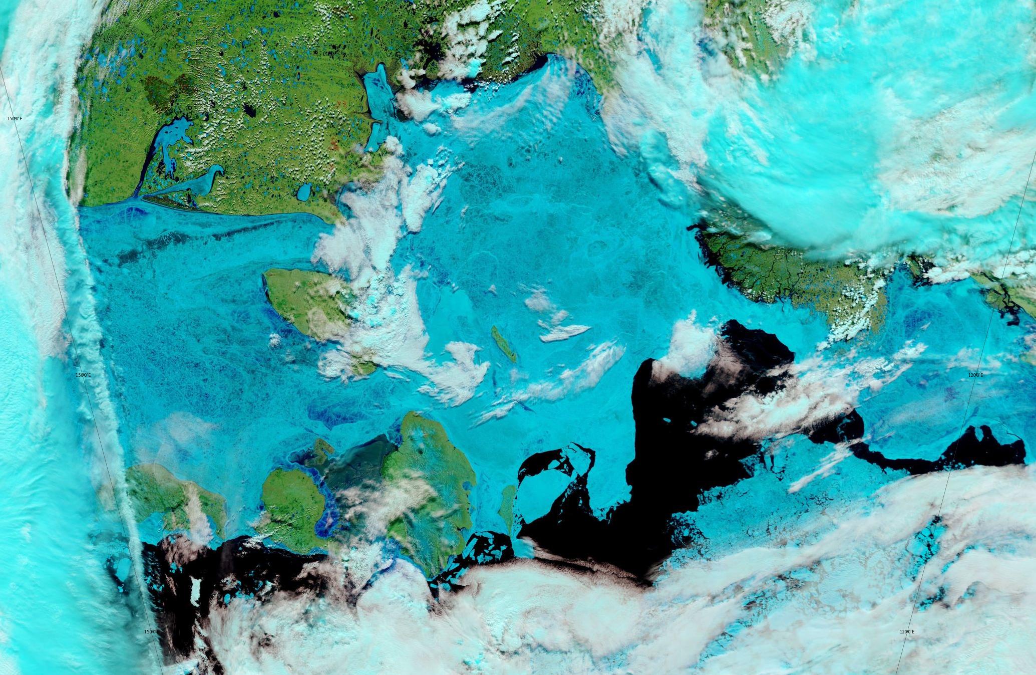
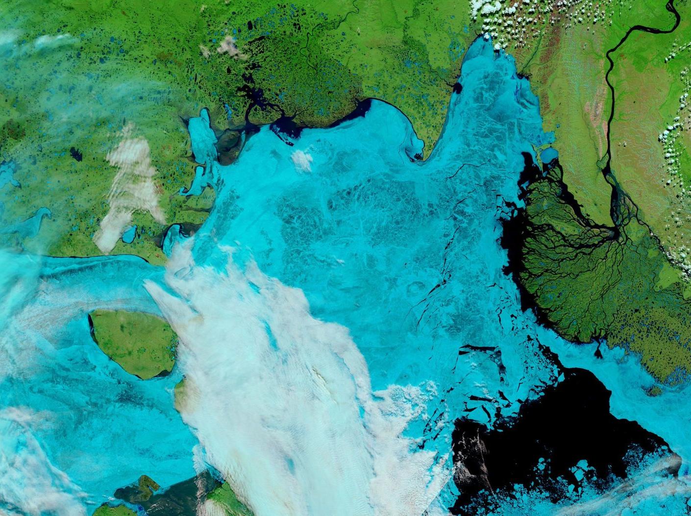
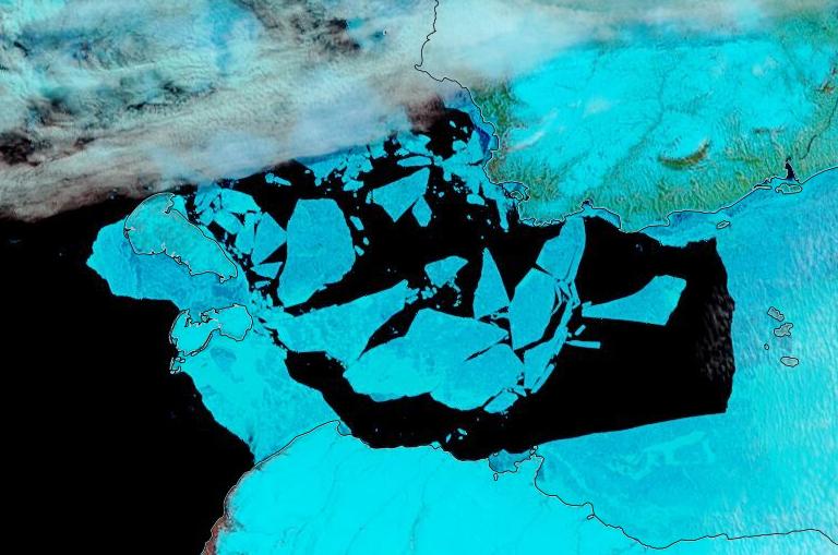
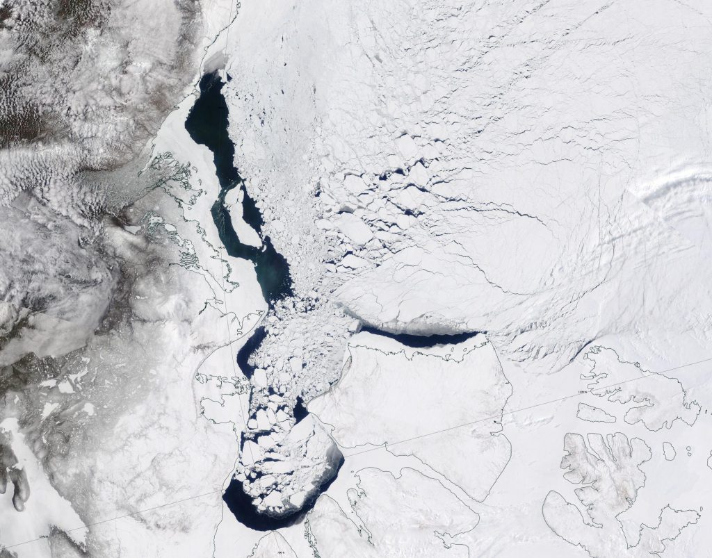
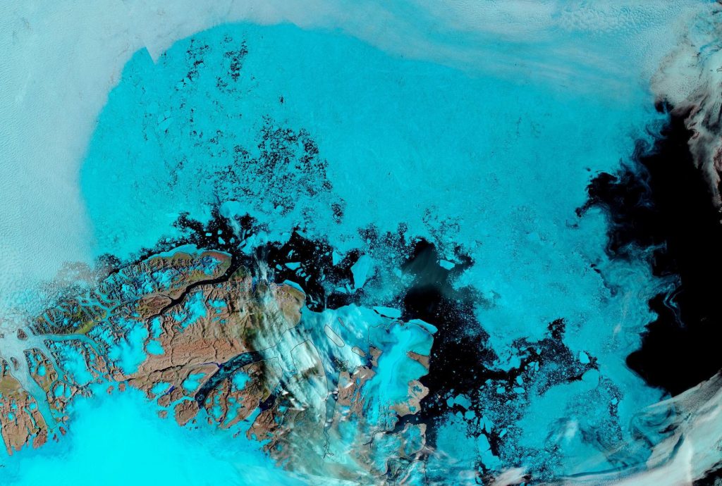
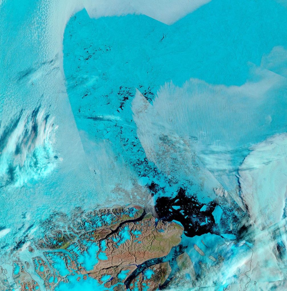
The forecast high pressure has arrived and the skies have cleared over the Beaufort Sea, which reveals that the land-fast ice off the Mackenzie Delta has started breaking up:

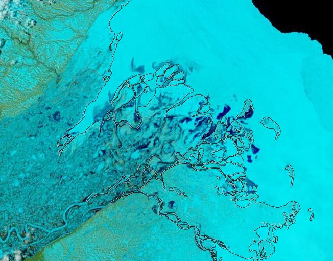
In addition the snow has been melting along the valley of the Mackenzie River, and the resulting increased flow at the mouth of the delta is flooding the fast ice:

Continue reading The Northwest Passage in 2021

The 2021 Maximum Arctic Sea Ice Extent

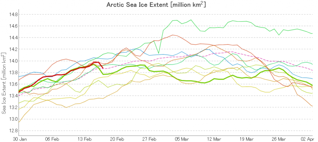
Here’s the latest graph of Arctic sea ice extent from JAXA/ViSHOP, with 2021 and 2015 highlighted:

Extent fell by over 100,000 square kilometres between February 16th and 17th! Can that steep fall continue, as it did for one more day in 2015?

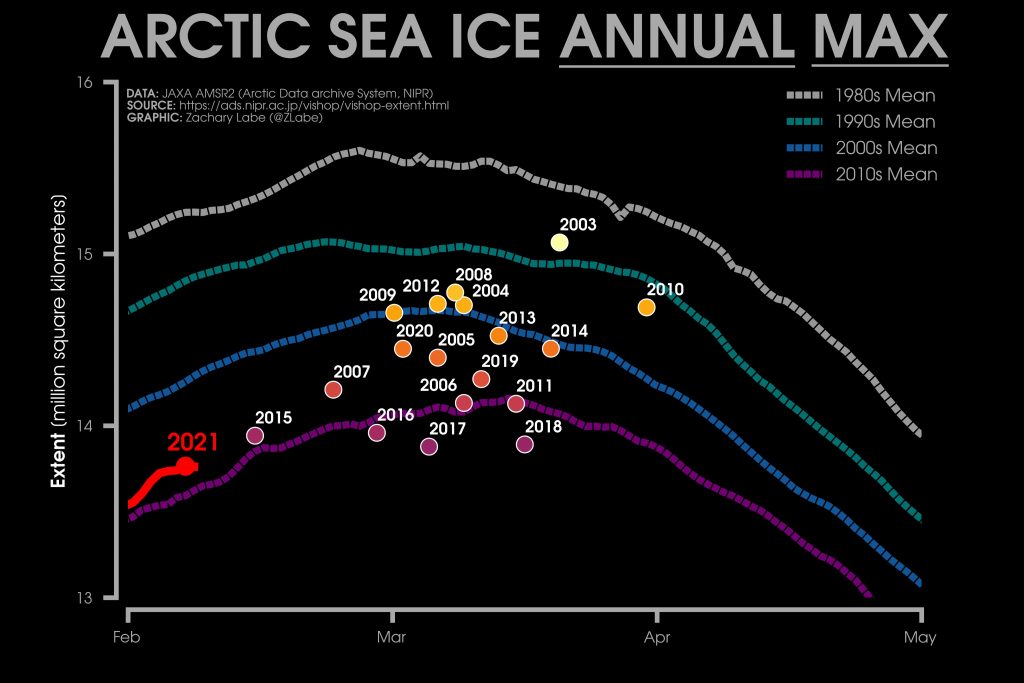
Here too is Zack Labe’s 2021 overview of JAXA maximum extent over the previous couple of decades:

2015’s maximum was very early, on February 15th. Hence the current extremely tentative 2021 maximum is already both higher and later than that. The decadal average extent graphs show the date of the maximum getting later and later, and the 2010’s peaks in the middle of March.

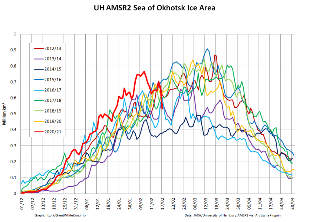
It therefore seems likely that there is more freezing still to come this year. However lets take a look at the high resolution AMSR2 sea ice area graph for the Sea Of Okhotsk:

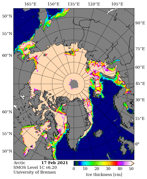
The recent fall in Arctic wide extent has evidently been driven by the recent rapid decline in this peripheral sea, where SMOS reveals more thin ice ripe for further melting:

In conclusion, the high res AMSR2 extent metric shows the tentative 2021 peak below that of 2015!

Continue reading The 2021 Maximum Arctic Sea Ice Extent

Facts About the Arctic in November 2020

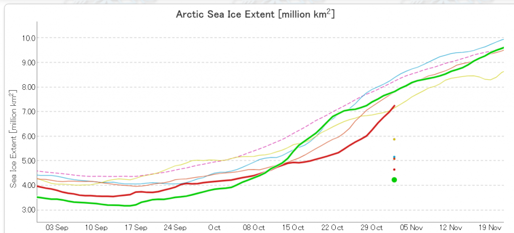
Arctic sea ice volume is of course far more important in the grand scheme of things. However sea extent is easier to measure, and the JAXA AMSR2 flavour thereof has now nudged into second place for the date above 2016:

[Edit – November 4th]

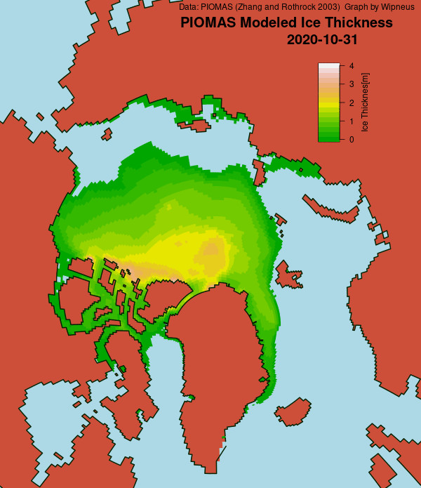
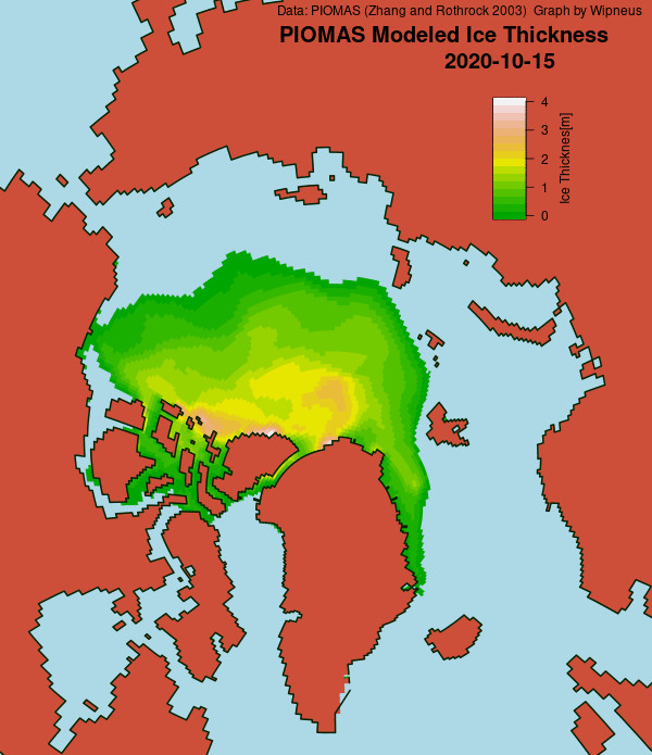
The PIOMAS gridded thickness numbers have been released, to reveal this end of October thickness map:

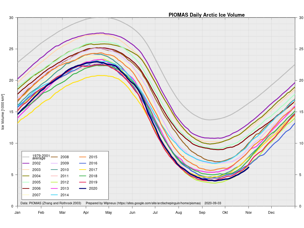
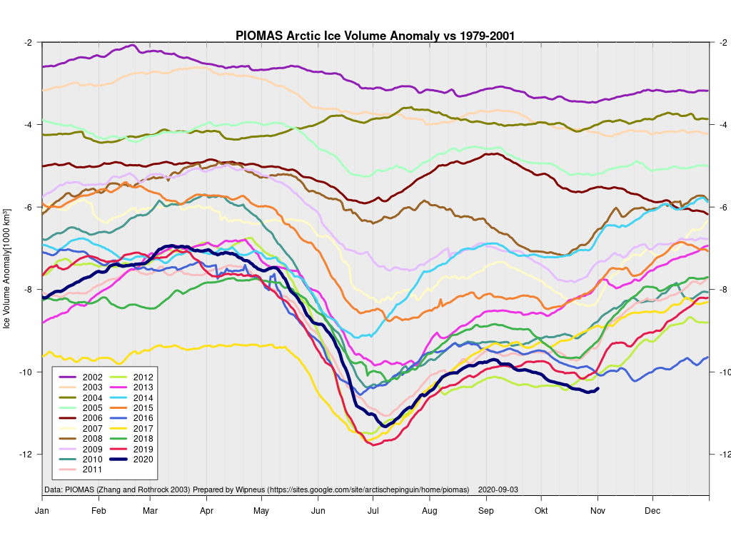
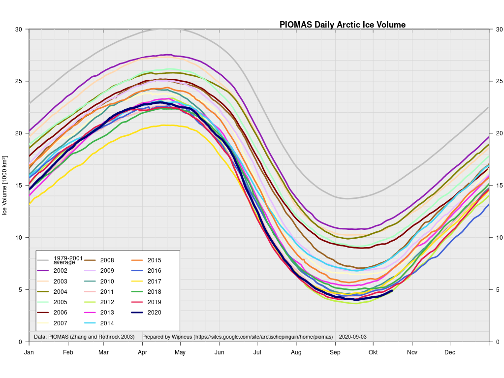
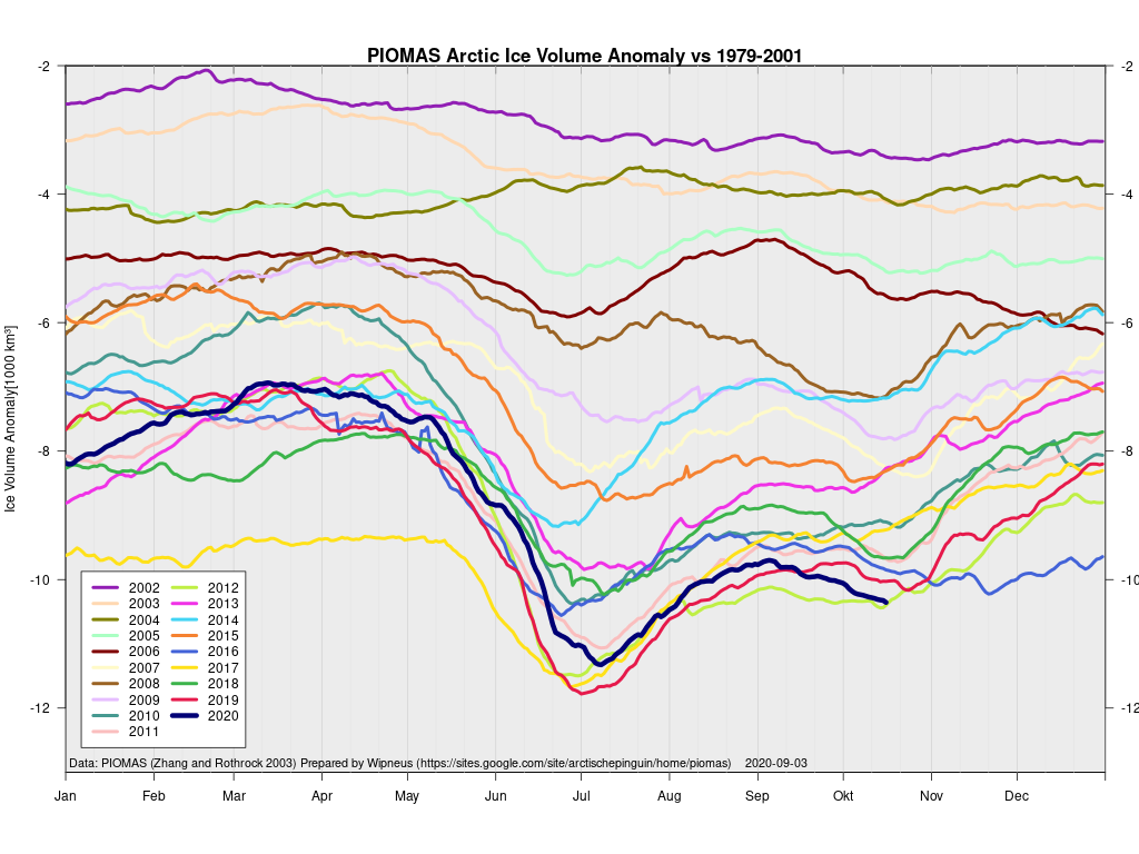
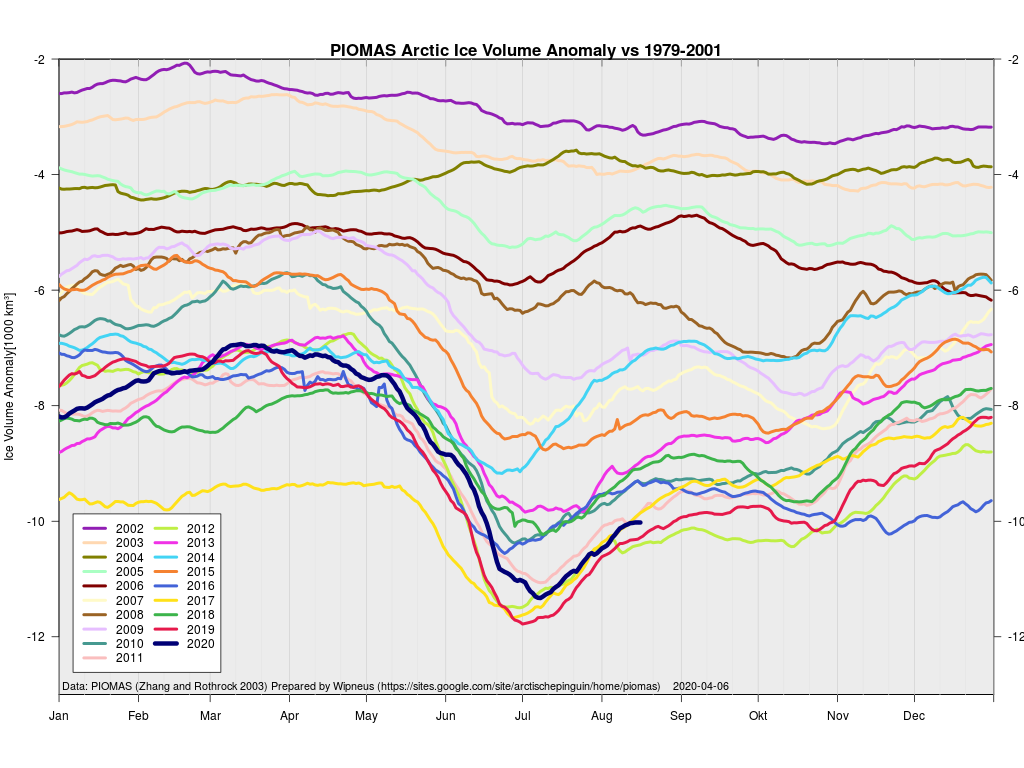
and these calculated volume graphs:

These show Arctic sea ice volume to be lowest for the date, even if extent has slipped into 2nd place.

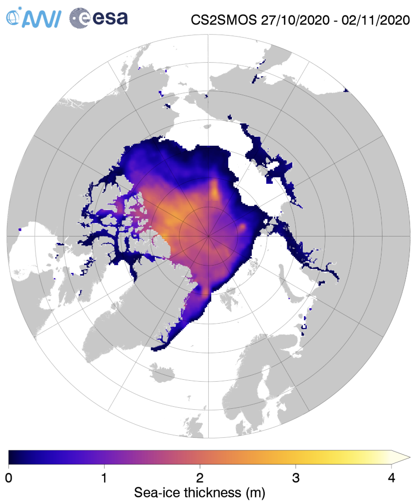
For comparison purposes here too is the latest AWI CryoSat-2/SMOS merged thickness map:

Continue reading Facts About the Arctic in November 2020

Facts About the Arctic in October 2020

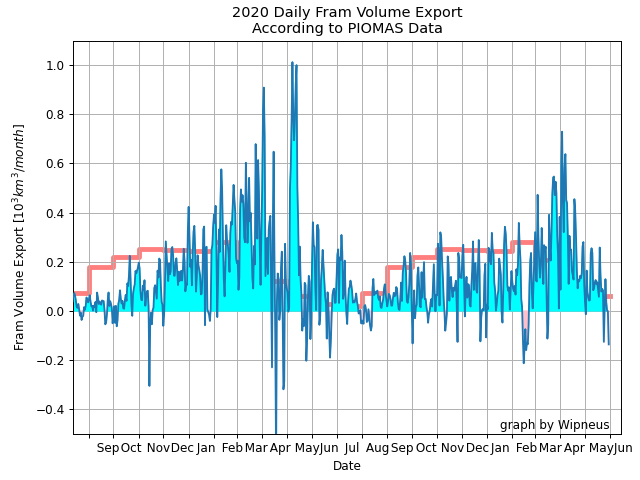
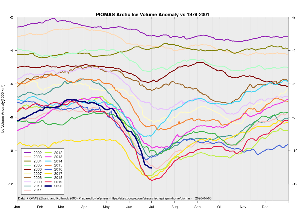
Let’s start this somewhat belated article by looking at Arctic sea ice volume. The mid month PIOMAS gridded thickness numbers have been released to reveal these volume graphs:

Minimum volume for 2021 was 4.03 thousand km3 on September 17th, 2nd lowest in the PSC record.

Modelled volume is now in a “statistical tie” with 2012 for lowest on record for mid October. Here too is the PIOMAS thickness map:

Meanwhile for comparison purposes here is the first merged Cryosat-2/SMOS thickness map of the 2020/21 freezing season, hot off the presses at the Alfred Wegener Institute:

Continue reading Facts About the Arctic in October 2020

The 2020 Arctic Sea Ice Minimum Extent

I’ve been waiting for the results of the ARCUS SIPN August call, but despite the timetable specifying “26 August 2020 (Wednesday)” they’ve still not been published and I can wait no longer!

Hopefully the August “predictions” will be available soon, but for the moment let’s take a look at the July 2020 Sea Ice Outlook instead:

For the Arctic, the median July Outlook for September 2020 average sea-ice extent is 4.36 million square kilometers, essentially identical to the median prediction in the June report, with quartiles of 4.1 and 4.6 million square kilometers. For comparison, the historical record September low over the period of satellite observations was set in 2012 at 3.57 million square kilometers, and the second lowest record was 4.27 million square kilometers set in 2007. This year’s projection is close to the 2019 observed September sea-ice extent of 4.32 million square kilometers. As was also the case for the June report, only two of the outlooks project September sea-ice extent below the 2012 record. The consensus judgement against a new record low September sea-ice extent hence remains unchanged. Interestingly, as of this report, observed extent stands at a record low for this time of year.

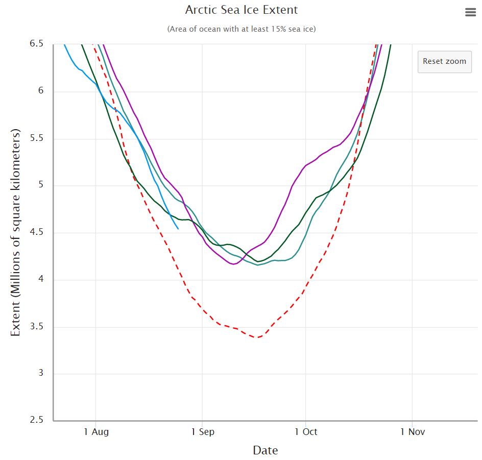
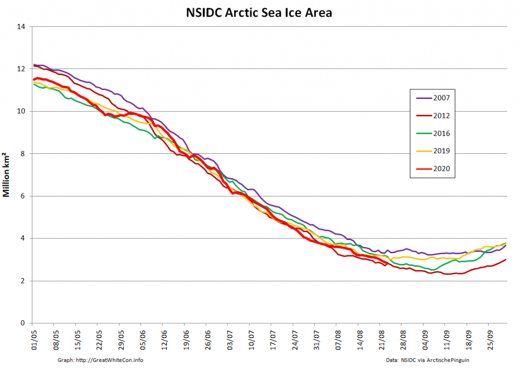
Note that those numbers represent “September 2020 average sea-ice extent” and not the daily minimum. Let’s now take a look at the assorted different flavours of “Arctic sea ice extent” metric. Firstly here’s the NSIDC’s “Charctic” 5 day average extent:

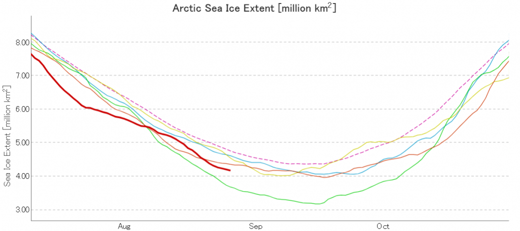
Next here’s JAXA/ViSHOP extent, generally assumed to be a “2 day average”:

Next here’s the DMI version, which neglects to include 2012:

Continue reading The 2020 Arctic Sea Ice Minimum Extent

Facts About the Arctic in August 2020

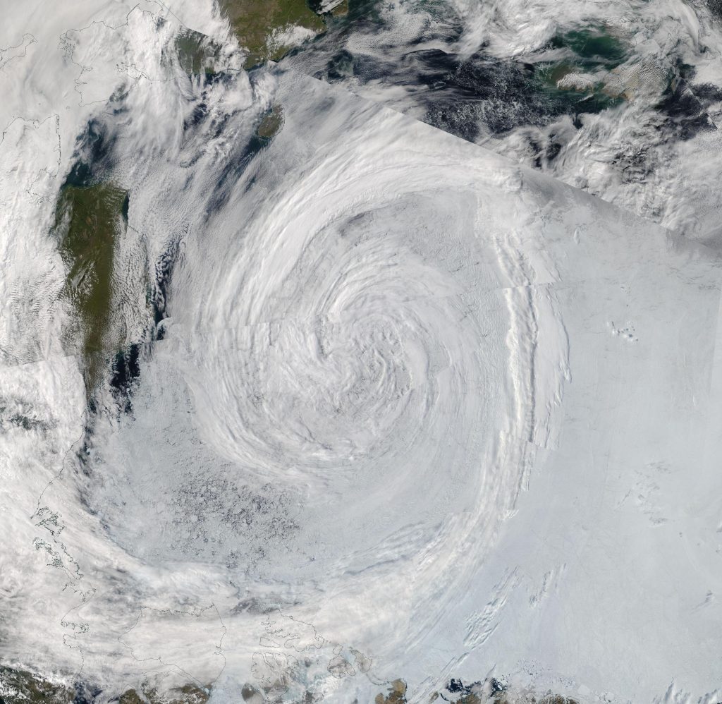
A new month begins today, and at the moment it looks as though it’s going to be the most interesting one since August 2012. Here once again is the satellite image of the enormous cyclone that was spinning over the Beaufort/Chukchi Seas just a few days ago:

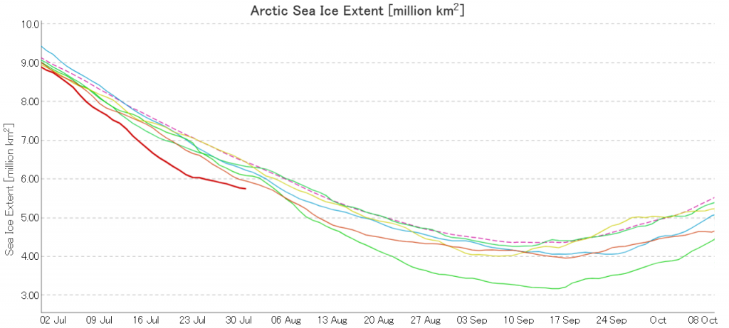
Here too is the effect of the cyclone on the trajectory of the JAXA Arctic sea ice extent graph:

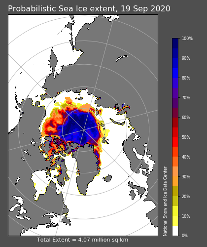
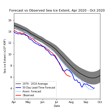
Here too is the current prognosis of the late Andrew Slater’s “Slater Probabilistic Ice Extent” 50 day forecast:

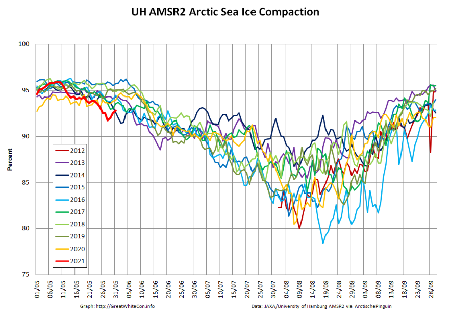
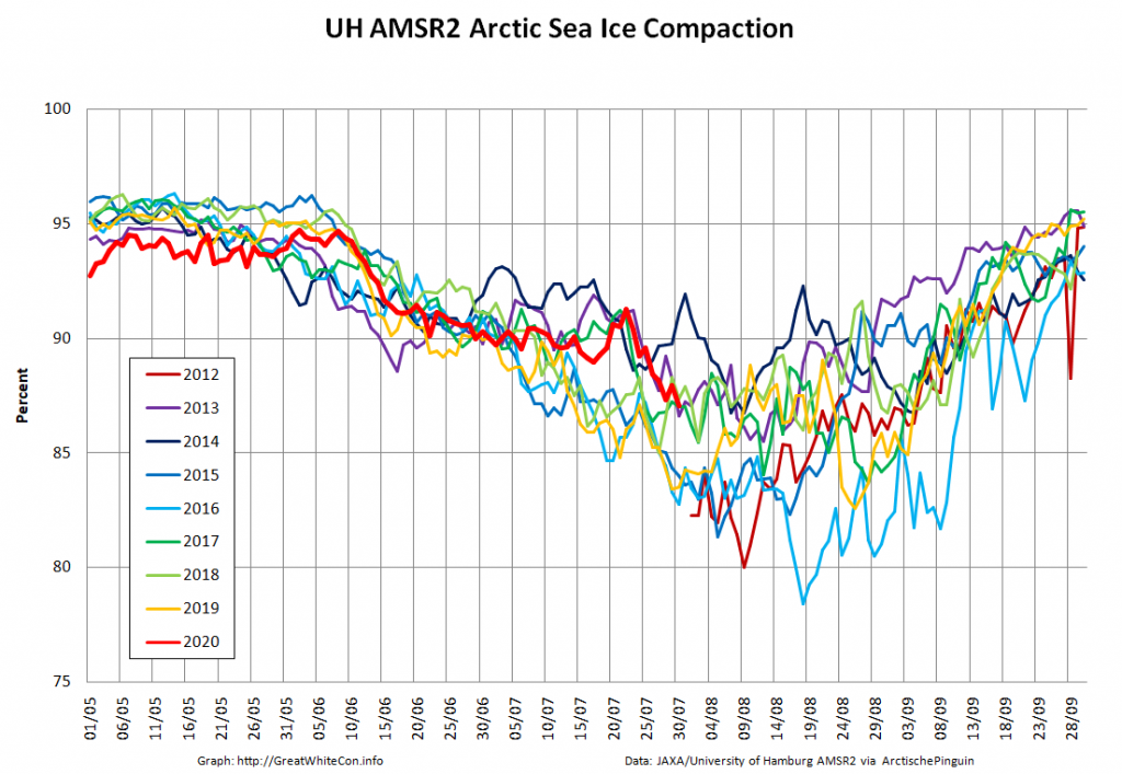
The cyclone has obviously resulted in a reduction in the rate of extent decline, but take a look at the high resolution AMSR2 “compaction” graph:

The gaps between the remaining sea ice floes have evidently increased, and hence the ice area is declining more rapidly than its extent.

[Edit – August 2nd]

Here’s an animation, based on the University of Hamburg’s AMSR2 concentration maps, which reveals the motion of the sea ice across the Beaufort and Chukchi Seas for the last two months:

Note in particular the side effects of the recent cyclone, visible at the end of the video.

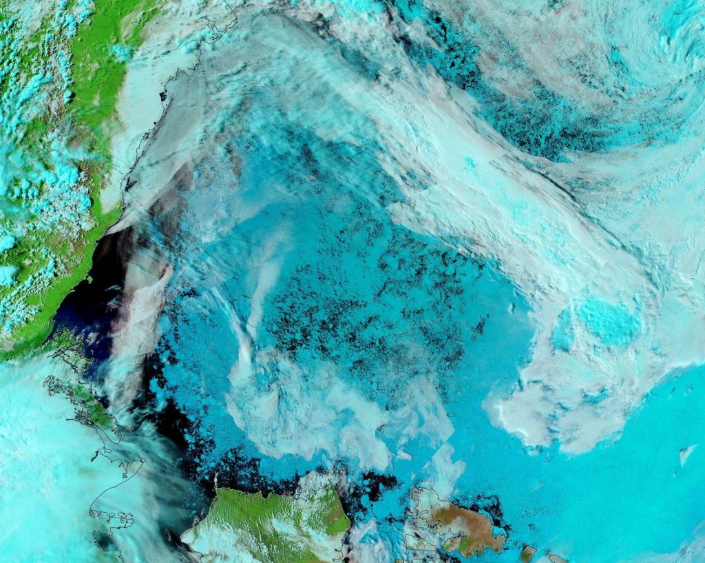
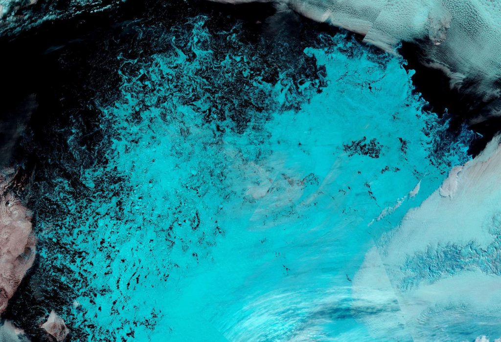
Here too is a close up of the current state of the remaining ice in the Chukchi Sea, snapped by the Suomi NPP satellite through a gap in the clouds:

Plus the current open water north of Greenland. Perhaps once Polarstern has been flushed out into the open water of the Fram Strait at the end of the MOSAiC expedition she could take another look at this almost completely unexplored area of the Arctic Ocean?

[Edit – August 6th]

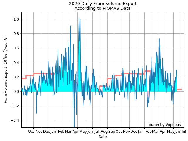
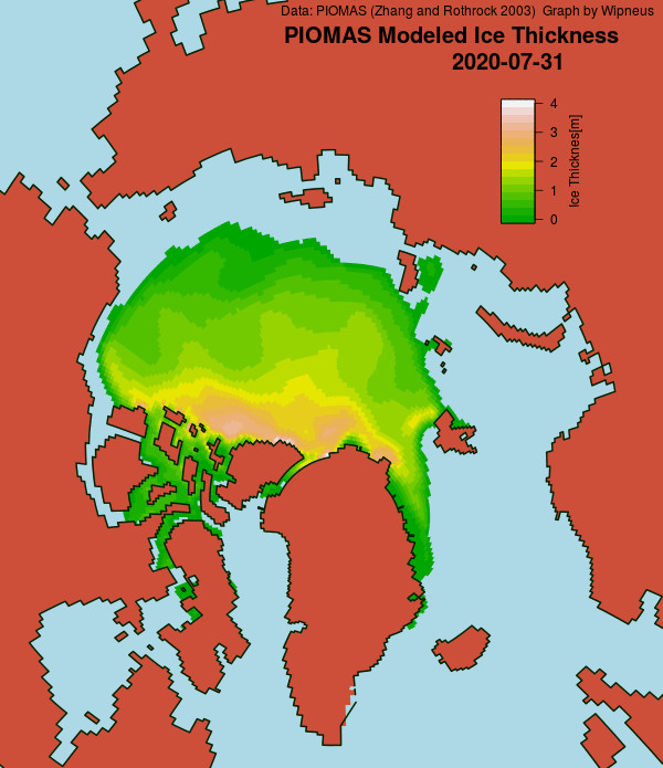
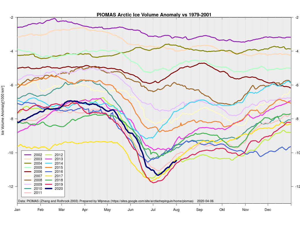
The latest gridded thickness data has been released by the PIOMAS team, and here are Wipneus’s visualisations:

According to the Polar Science Center:

Average Arctic sea ice volume in July 2020 was 9,300 km3. This value is  only 400 km3 above the  record minimum  value of 8,900 km3 set in 2019. This makes 2020 the fourth lowest on record for July with 2012, 2017,2019 falling just below 2020.

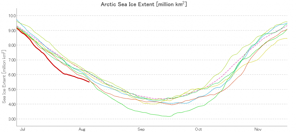
JAXA extent is still lowest for the date, but following the recent cyclone it looks as though it will not maintain that position for much longer:

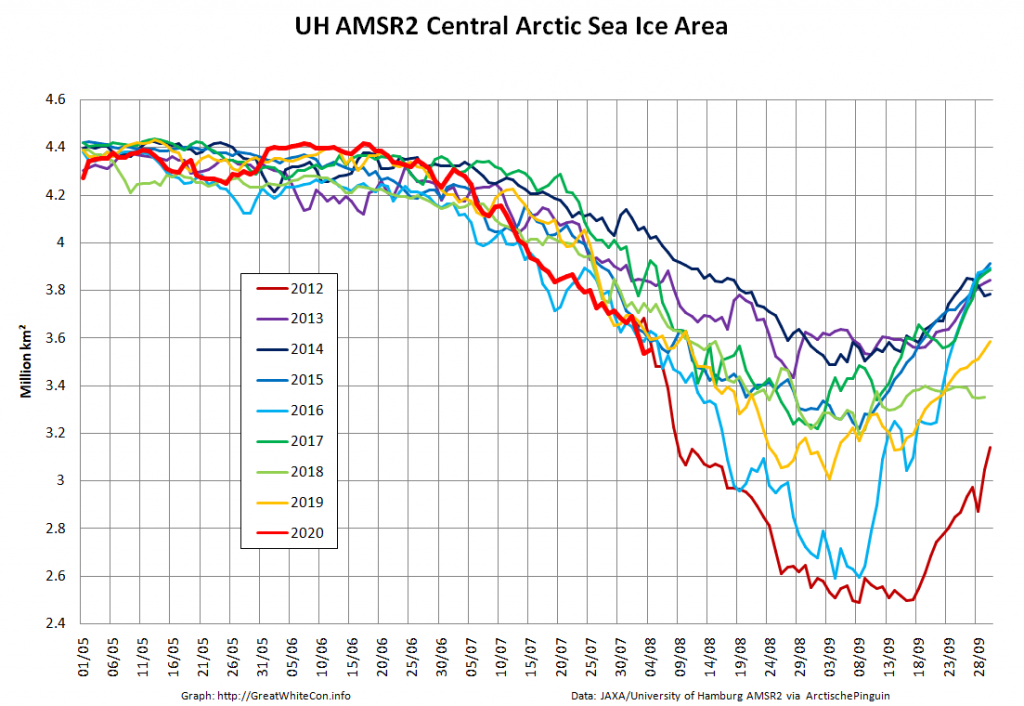
Now we’re in the month of August it’s possible to do a direct comparison with AMSR2 data for 2012. Here’s sea ice area for the Central Arctic Basin:

[Edit – August 8th]

All of a sudden JAXA extent is in 3rd place in the race to the minimum:

However let’s also take a close look at the state of the sea ice in the Beaufort and Wandel Seas shall we?

At this juncture I reckon that come mid September second place is now more likely than first. However as always, it still all depends on the weather.

[Edit – August 9th]

Surprising as it may seem, high resolution AMSR2 Central Arctic Basin sea ice area has so far managed to keep up with the precipitous drop in 2012:

North of Greenland the clouds have cleared closer to the North Pole, to reveal this:

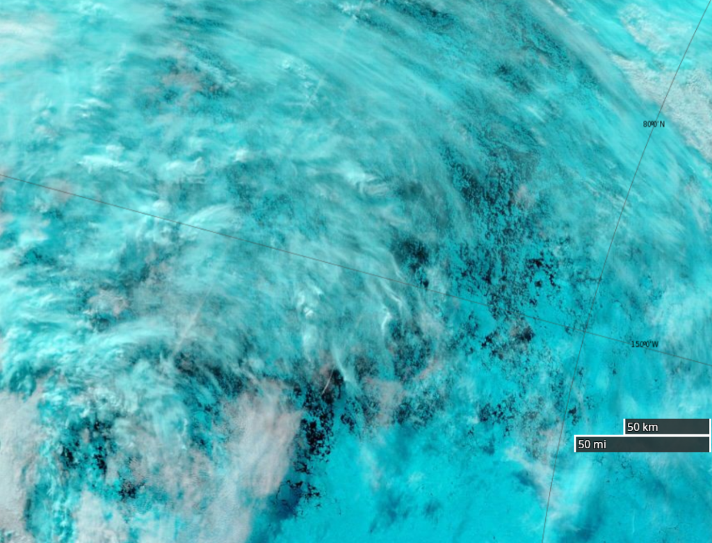
Fresh this morning from Terra, a rather cloudy view of the devastation near 80N, 150W:

[Edit – August 10th]

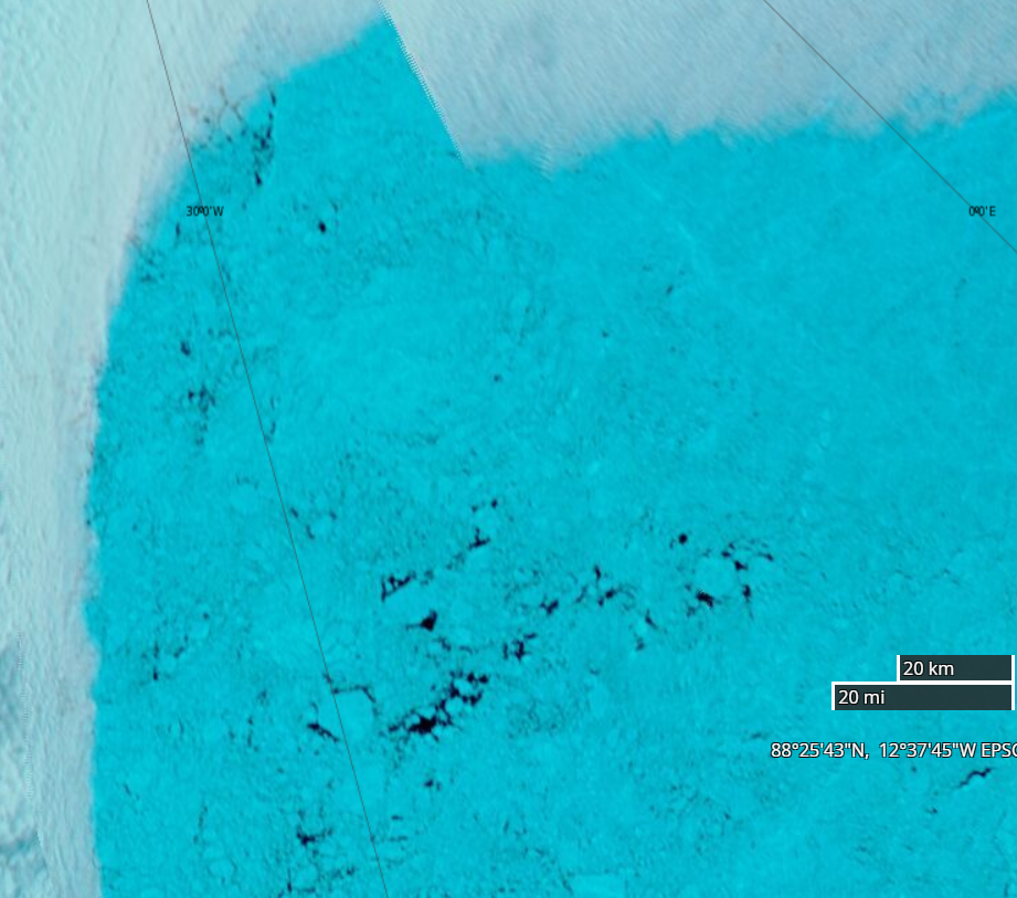
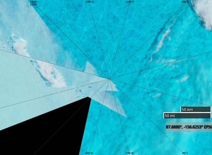
In a not entirely unexpected development one of ex Prof. Judy’s denizens is quibbling about the current condition of sea ice in the Arctic. Hence here is a close up of some “gaping holes in the sea ice cover” at 88N between Greenland and the North Pole:

[Edit – August 13th]

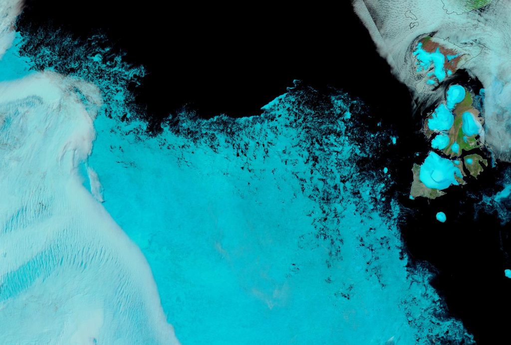
A nice clear view this morning of the marginal ice zone of the “Laptev Bite” and thereabouts from the Suomi satellite :

[Edit – August 16th]

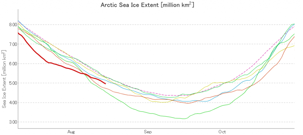
JAXA AMSR2 extent has fallen below 5 million km²:

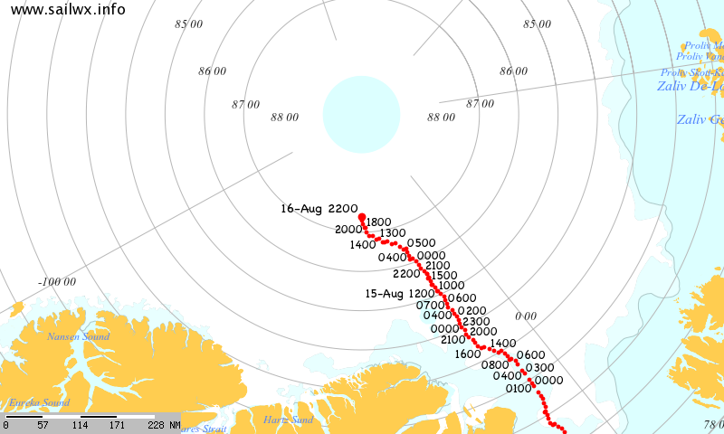
Having been flushed out of the Central Arctic through the Fram Strait the polar research vessel Polarstern is back, seemingly intent on taking a close look at the North Pole:

[Edit – August 19th]

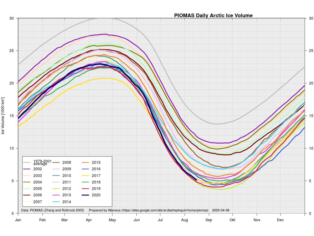
The mid month PIOMAS gridded thickness numbers have been published:

According to the Polar Science Center model Arctic sea ice volume is currently third lowest after 2012 and 2019.

[Edit – August 24th]

Arctic sea ice area based on NSIDC concentration data is now in a “statistical tie” with 2012 for the honour of “lowest for the date” in the satellite record:


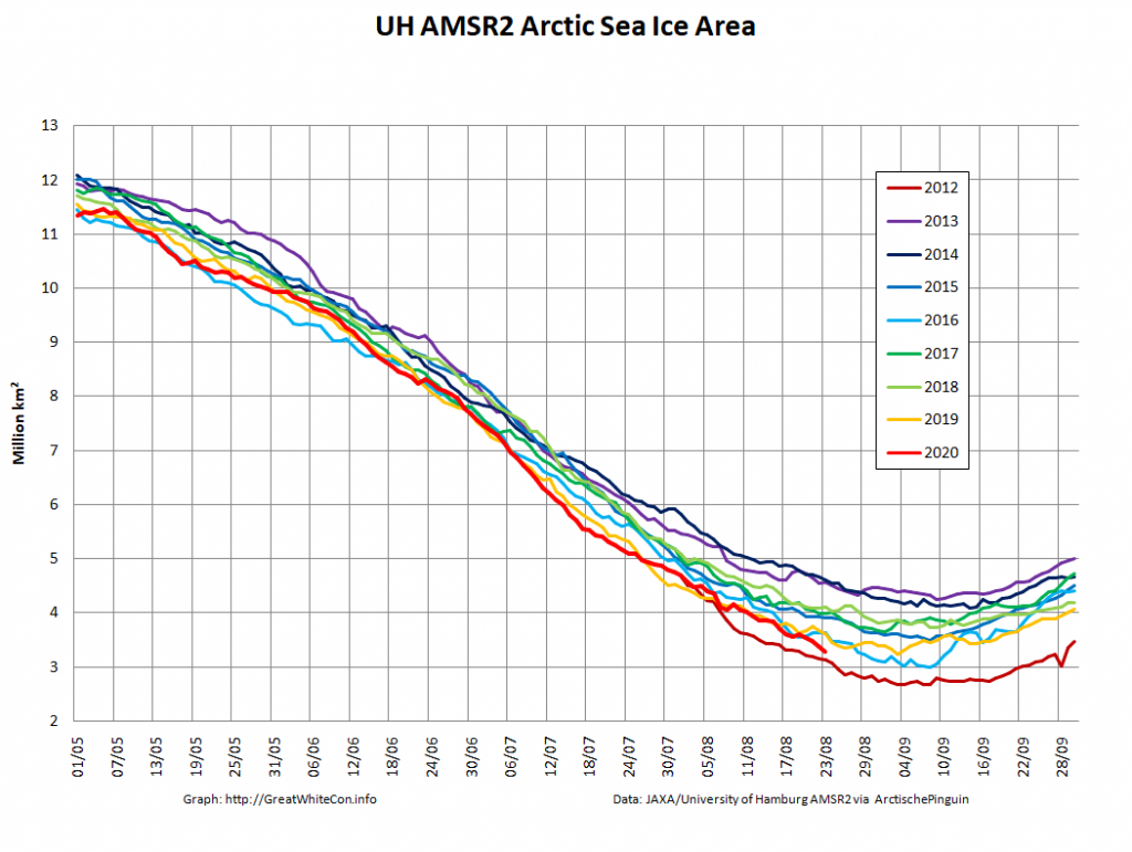
High resolution AMSR2 area isn’t far behind:

[Edit – August 24th]

A nice clear view of the disintegrating sea ice north of the East Siberian and Chukchi Seas yesterday:

Watch this space very closely for the next few weeks!

Facts About the Arctic in July 2020

The new month starts with JAXA extent “lowest for the date in the satellite record” by a whisker:

The high resolution Arctic sea ice area and extent graphs based on the University of Hamburg’s AMSR2 concentration data are also in “statistical ties” for that honour, in records going back to 2013:

The 2020 melting season currently seems to be a game of two (geographical) halves. The sea ice on the Siberian side of the Arctic is currently at record lows:

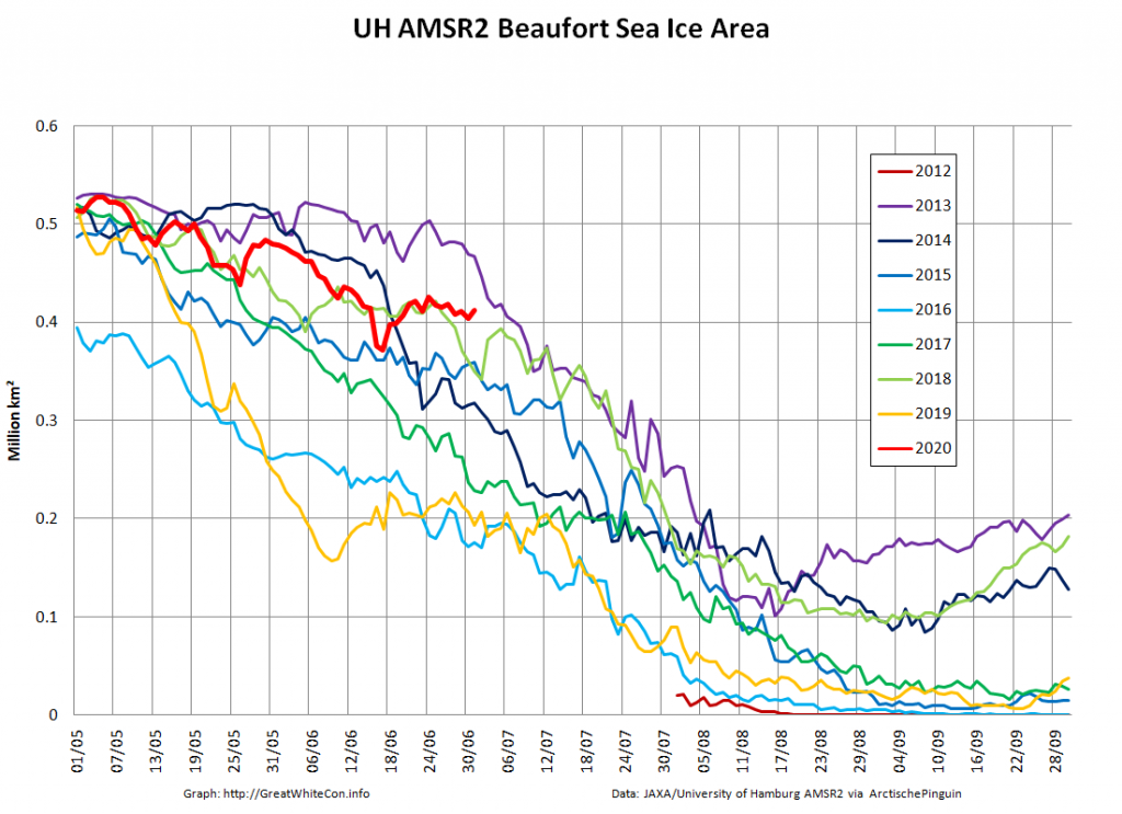
Whereas the Beaufort Sea is near a record high:

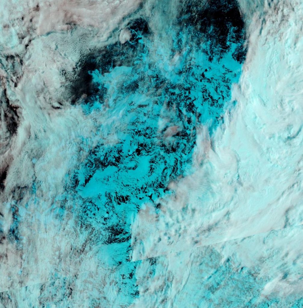
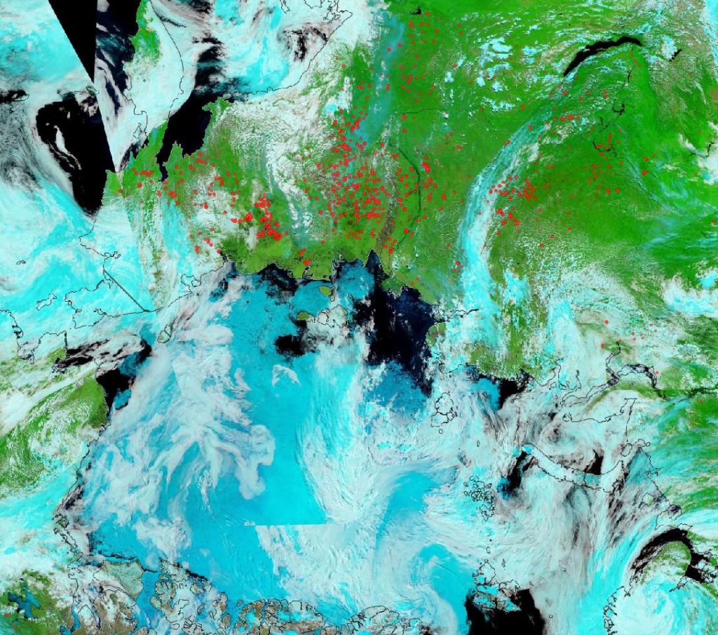
Currently the tell tale signs of surface melt are visible across most of the central Arctic, as are the large number of wildfires across Arctic Siberia:

NASA Worldview “false-color” image of the Arctic on July 1st 2020, derived from the MODIS sensor on the Terra satellite

[Edit – July 4th]

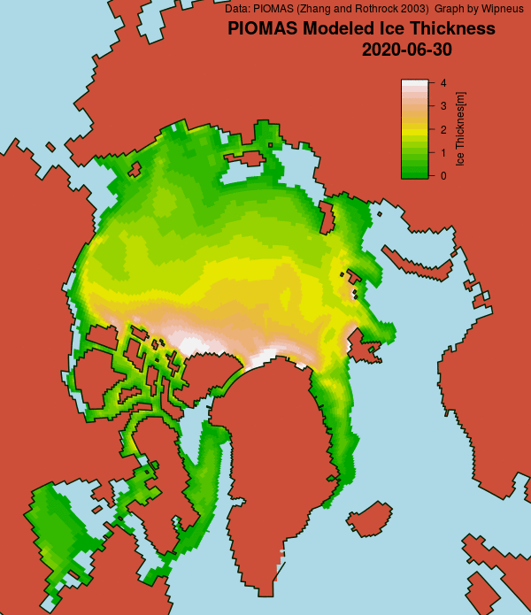
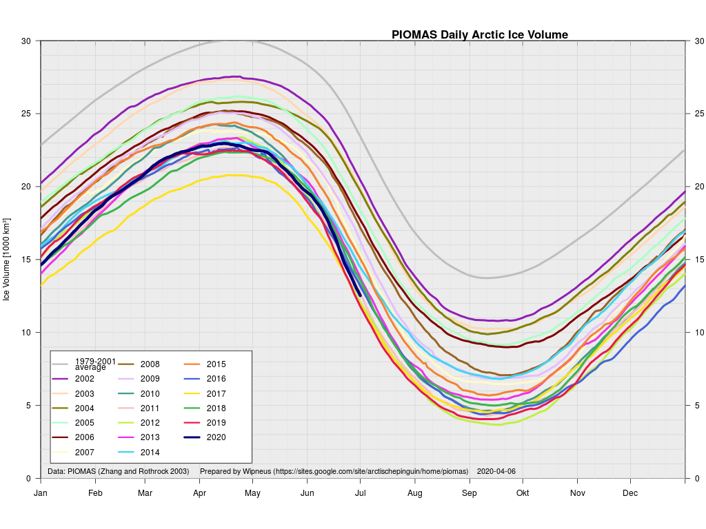
The June 30th PIOMAS gridded thickness numbers have been released, and here are the results of Wipneus’s number crunching:

This month including a visualisation of the increasing negative anomaly:

[Edit – July 6th]

A break in the clouds over the North Pole reveals the onset of surface melt:

NASA Worldview “false-color” image of the North Pole on July 6th 2020, derived from the MODIS sensor on the Terra satellite

[Edit – July 8th]

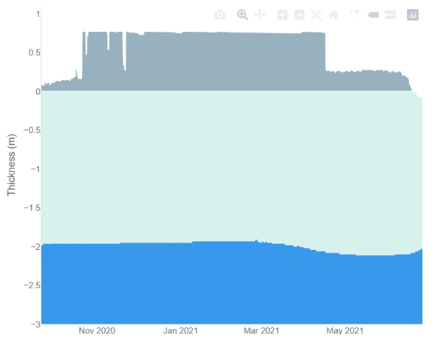
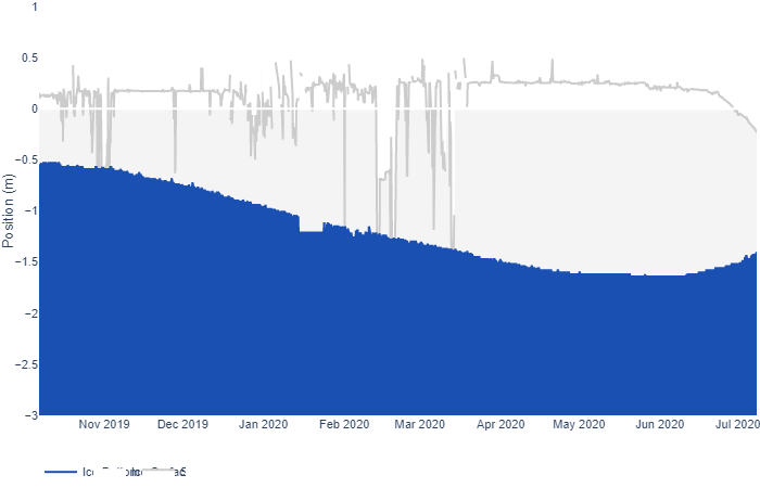
After a brief hiatus there are once again some ice mass balance buoys installed at assorted locations across the Arctic. Some have ceased to function, but one of the buoys installed as part of the MOSAiC expedition is still sending back data as it heads towards the Fram Strait. Buoy 387850 is currently located at 81.66 N, 4.19 E. Here’s its ice mass balance plot:

As you can see, both surface and bottom melt are well under way, with just over a meter of ice still remaining.

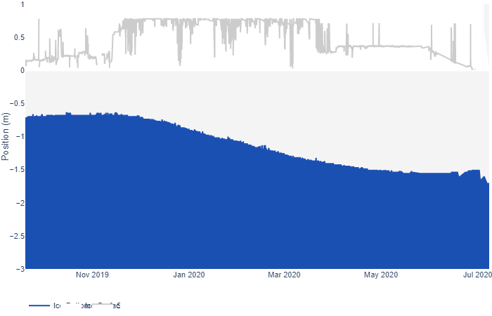
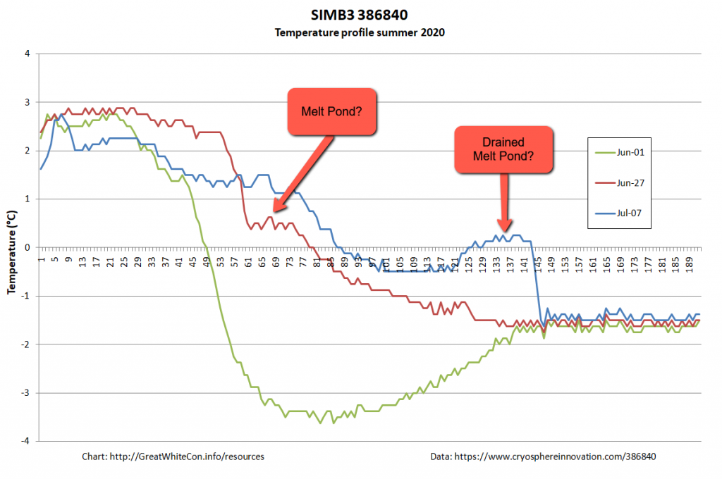
Now let’s take a look at buoy 386840, currently located at 74.30 N, 132.60 W in the Beaufort Sea:

It looks as though the ice thickness has increased, but surely that can’t be right at this time of year? To try and find out I downloaded the raw data and plotted the temperature readings from the buoy’s thermistor string:

It looks to me as though the ice floe carrying the buoy is currently floating on some warm fresh water from a recently drained melt pond, which is confusing the sensor designed to measure the position of the bottom of the ice. There certainly seems to be far less than the claimed “1.653 m snow and ice thickness” still remaining to be melted!

[Edit – July 15th]

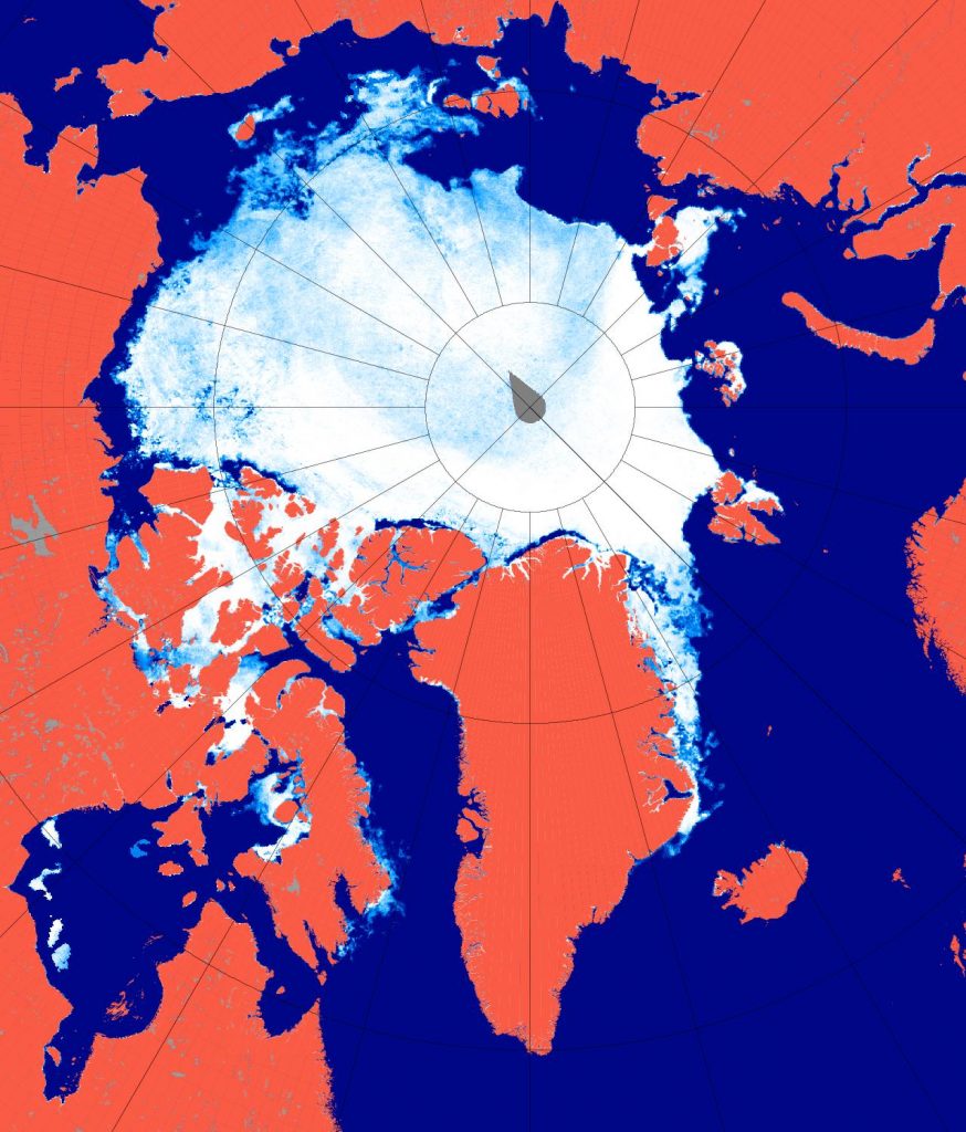
A very unusual image. Hardly a cloud in the sky over the North Pole yesterday:

NASA Worldview “false-color” image of the North Pole on July 14th 2020, derived from the MODIS sensor on the Terra satellite

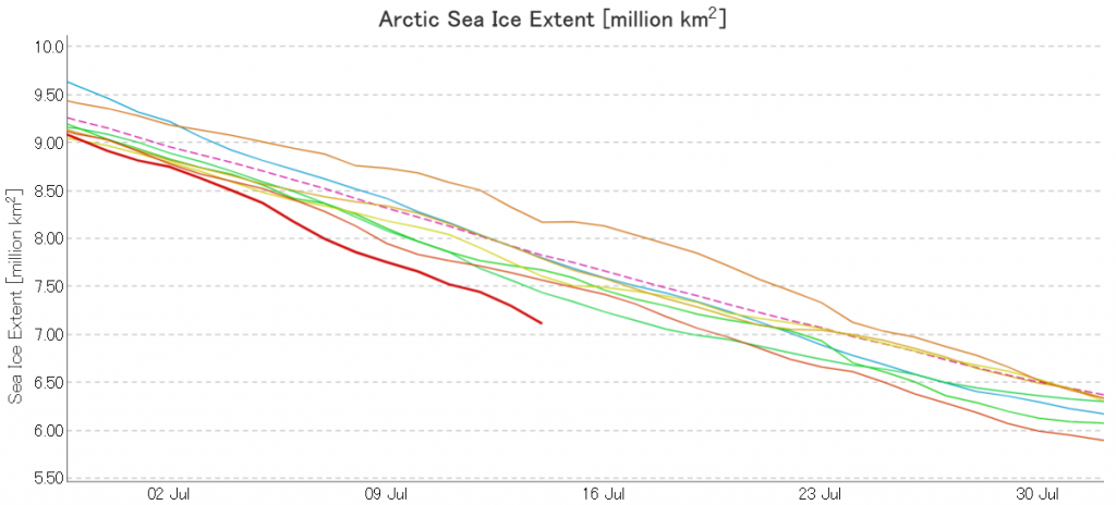
The July 2020 extent “plummet” shows no signs of ending just yet. Here’s the JAXA/ViSHOP version:

[Edit – July 17th]

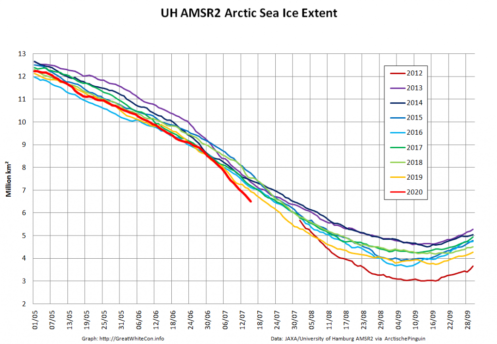
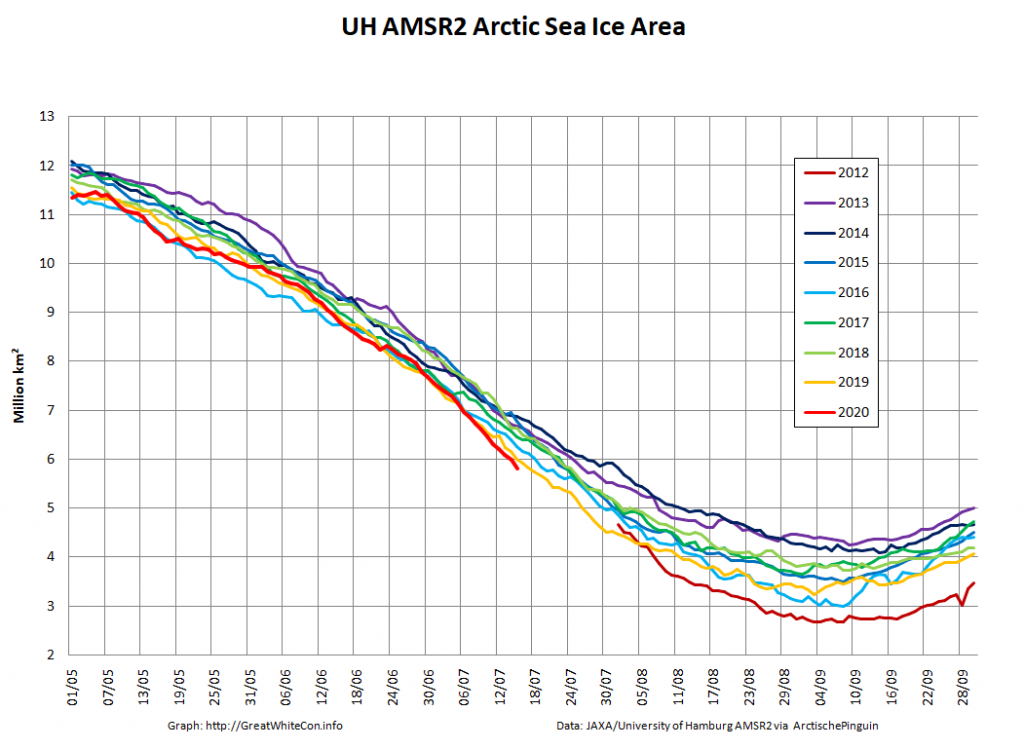
JAXA AMSR2 extent is now below 7 million km², and the high resolution version is lower still:

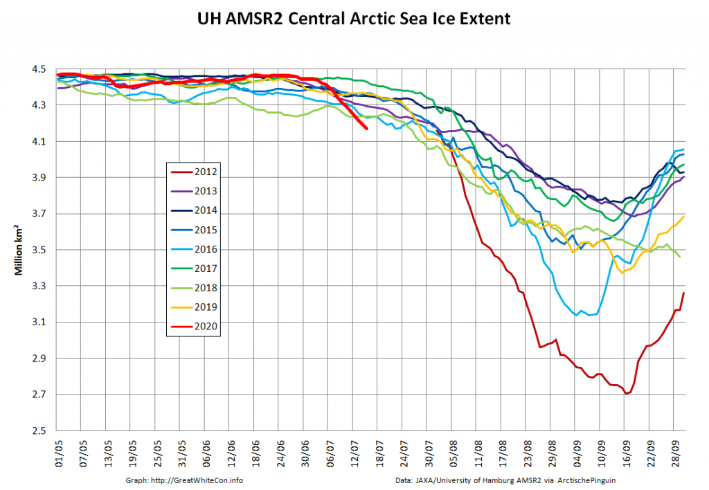
As the “Laptev Bite” and the Atlantic periphery of open water extends further towards the North Pole, Central Arctic Basin extent is now also at record lows for the date in the AMSR2 record:

[Edit – July 19th]

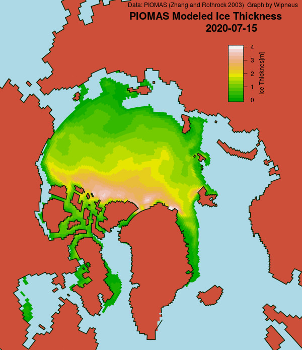
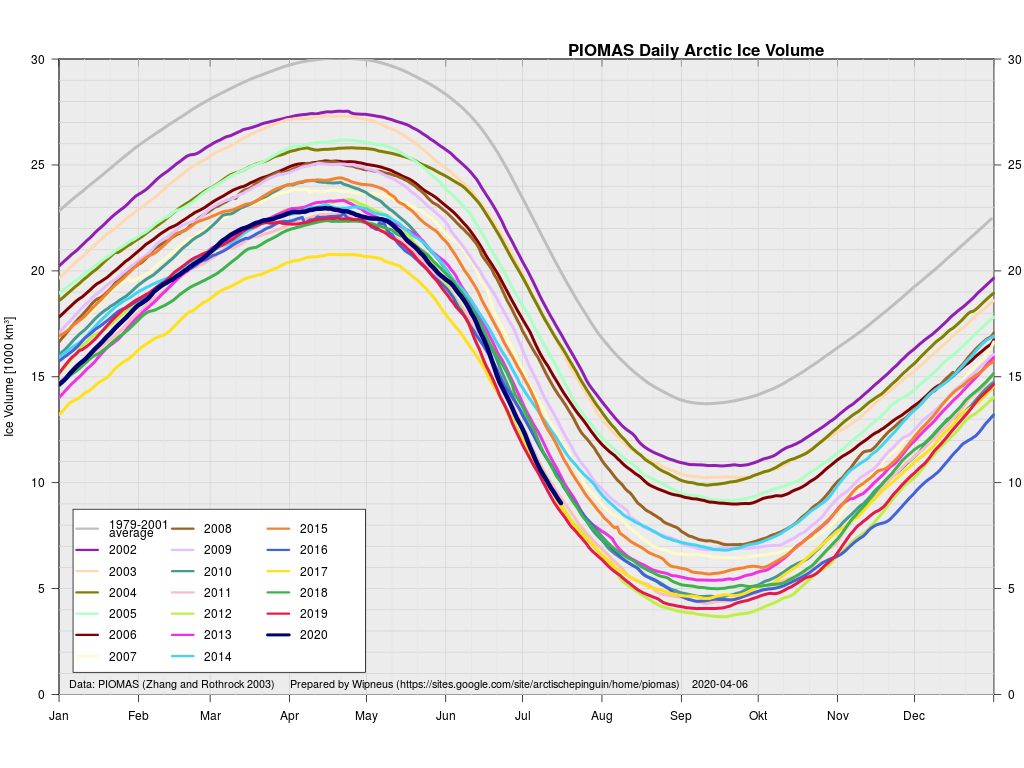
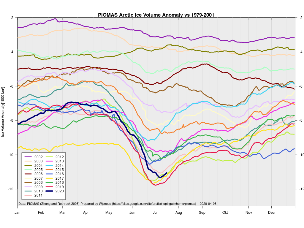
Wipneus has crunched the mid month PIOMAS gridded thickness numbers, and here are the results:

Extent is currently lowest in the satellite era by a long way, but modelled volume is only fourth lowest!

Watch this space!

[Edit – July 21th]

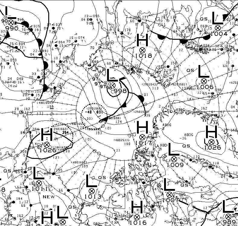
At long last there’s a sub 1000 hPa MSLP low pressure area slowly wending its way across the central Arctic:

It seems to have bottomed out at 997 hPa. Perhaps this will inhibit the ongoing “plummet” in extent? JAXA extent fell by 114,342 km2 yesterday.

[Edit – July 23rd]

The Northern Sea Route has opened unusually early this year:

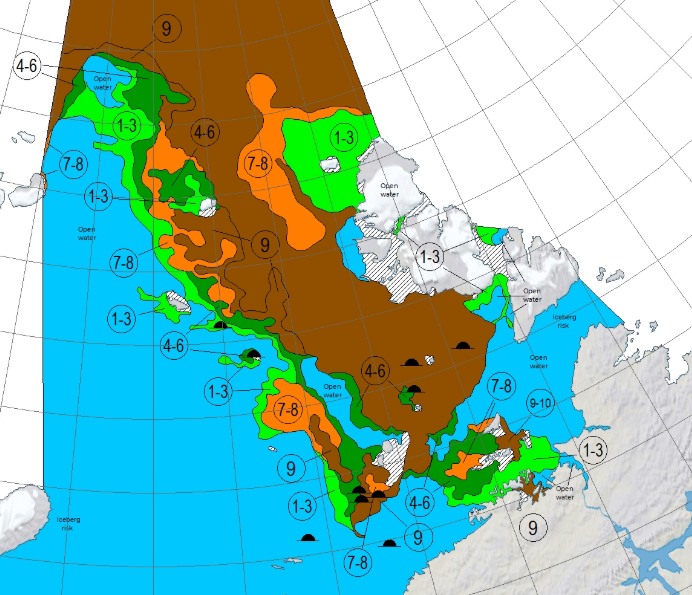
Based on the AMSR2 concentration maps from the University of Hamburg that happened on July 13th. The final choke point, as is so often the case, was the Vilkitsky Strait. According to the charts from the Russian Arctic and Antarctic Research Institute, by the 14th there was a narrow way through occupied by no more than 3/10 concentration ice:

[Edit – July 25th]

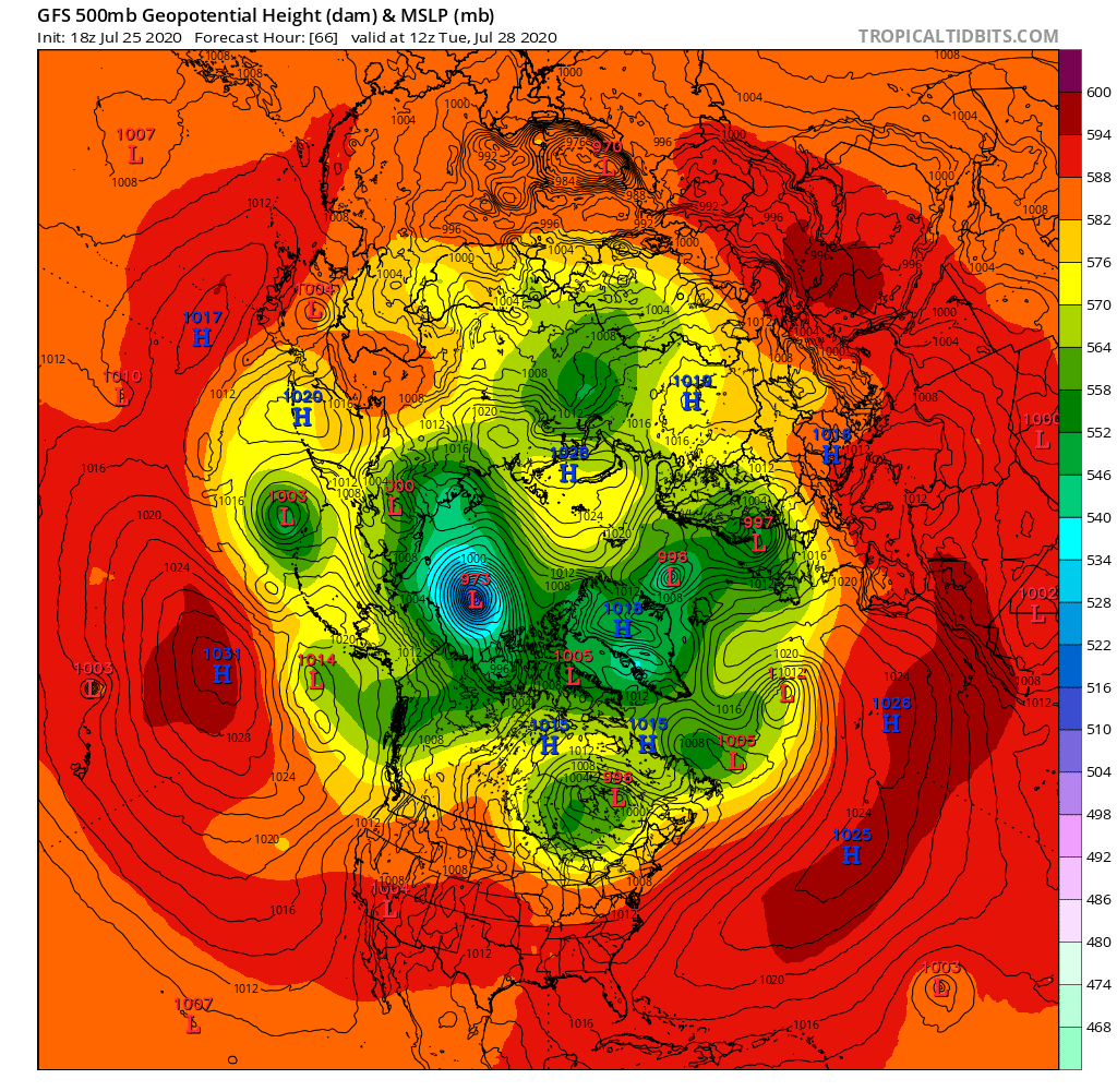
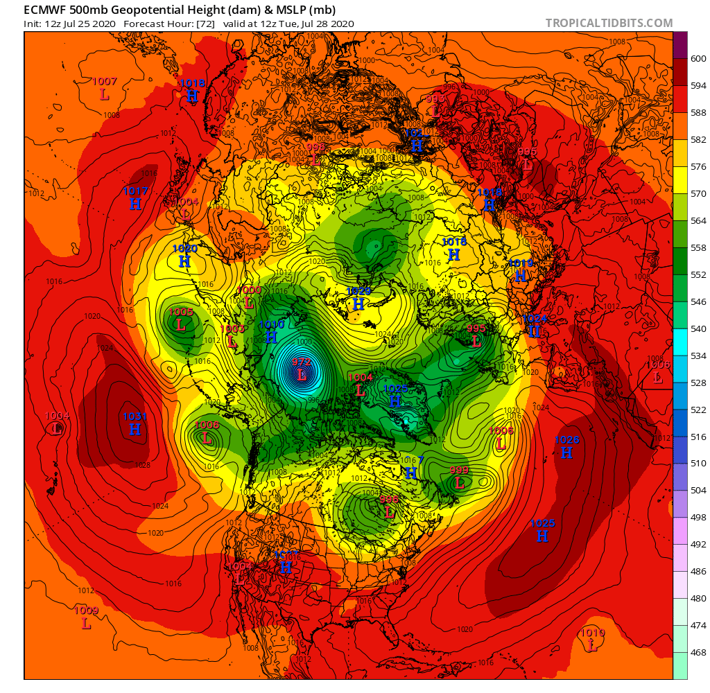
A mere three days away, and the GFS and ECMWF forecasts are in agreement, so there is a decent chance this setup will materialise in the real world:

Graphics via Tropical Tidbits

A 972(ish) hPa MSLP cyclone sitting over the ice Beaufort Sea by 12Z on Tuesday.

[Edit – July 27th]

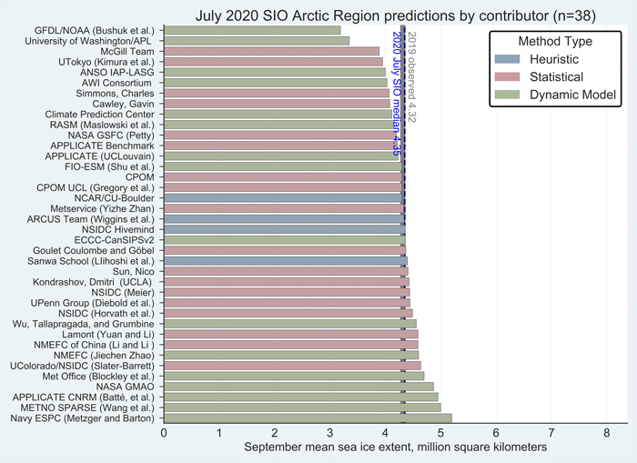
The Sea Ice Prediction Network July forecast for this year’s September minimum extent have been released. Here’s the graphical overview:

This year’s median projected value from the July forecasts of 4.3 million square kilometers is essentially identical to the median from the June forecasts. Quartiles are 4.1 and 4.6 million square kilometers. As was also the case for June, only two projections, both by dynamic models, are for a new record low, below the mark of 3.57 million square kilometers set in 2012. One dynamical model predicts the September sea-ice extent above 5.0 million square kilometers, compared to two in the June report.

Note that the numbers quoted are for the average NSIDC extent across the month of September, not the lowest daily JAXA extent, which I suggested earlier would be “below 4 million km²” this year.

Meanwhile over on Twitter this evening (UTC):

[Edit – July 28th]

The MSLP of the (Great?) Arctic cyclone sank below 970 hPa overnight:

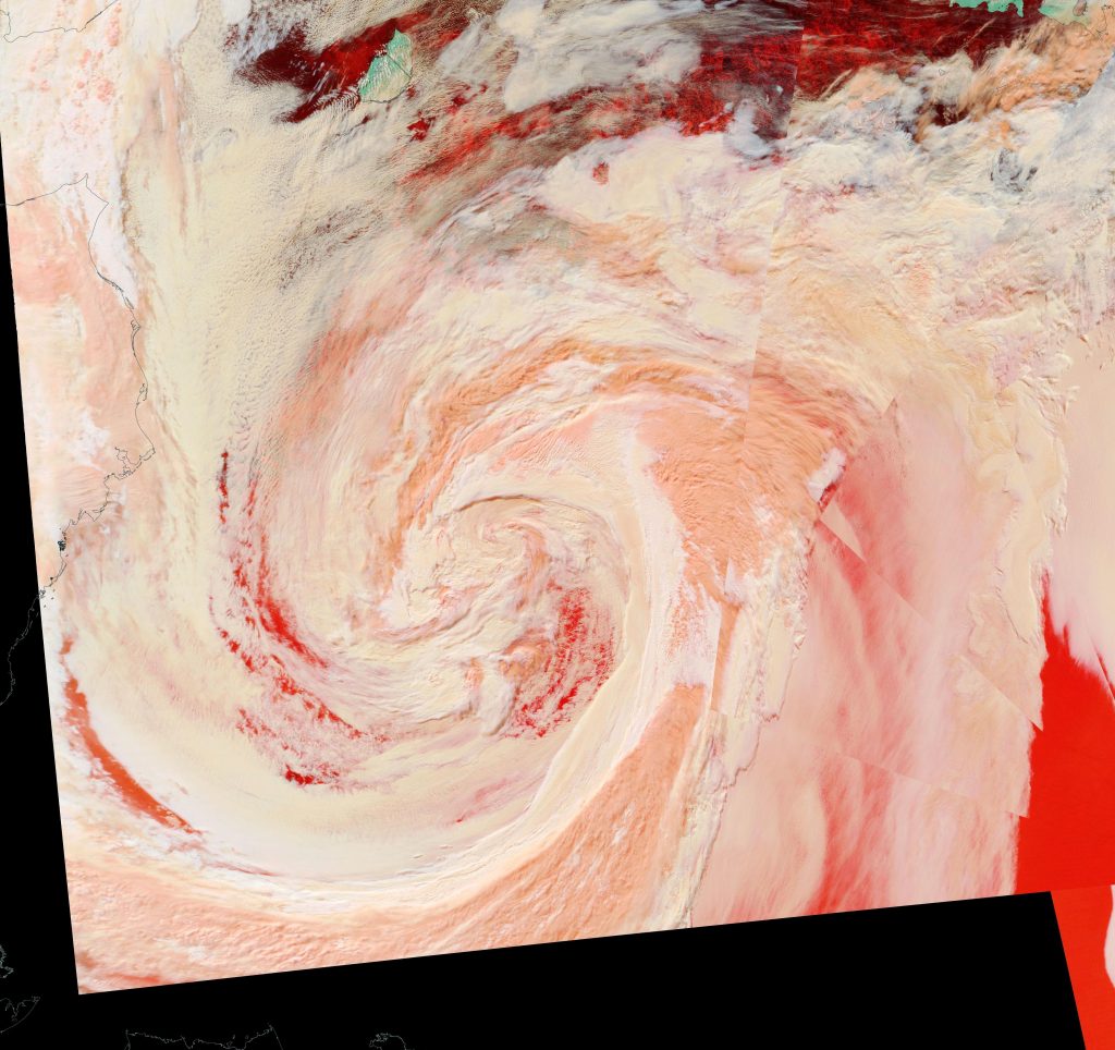
Here’s an early false colour snapshot of how (s)he looks from on high this afternoon (UTC), courtesy of the MODIS instrument on the Terra satellite:

[Edit – July 29th]

First up today we have a more complete “true colour” image of the cyclone doing its worst yesterday, including a fairly clear view in the bottom left corner of the initial damage to the sea ice covering the eastern Beaufort Sea. This one is from the Aqua satellite:

Watch this space!
Facts About the Arctic in June 2020

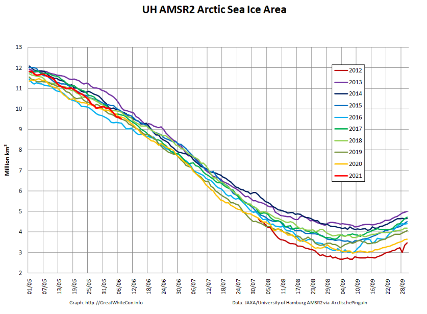
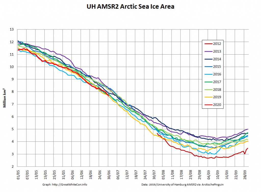
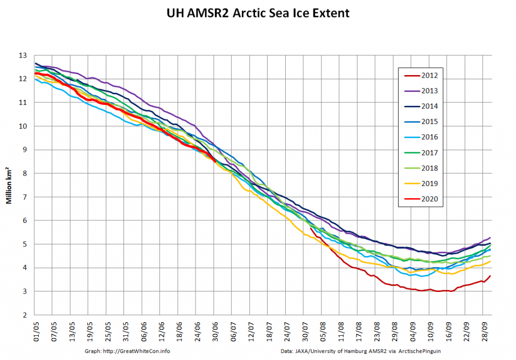
As is our current habit this month’s report begins with the high resolution Arctic sea ice area and extent graphs based on the University of Hamburg’s AMSR2 concentration maps:

Area and extent are currently vying for second place with 2019 on the “lowest for the date” leader board, a little behind 2016 at this point in the 2020 melting season.

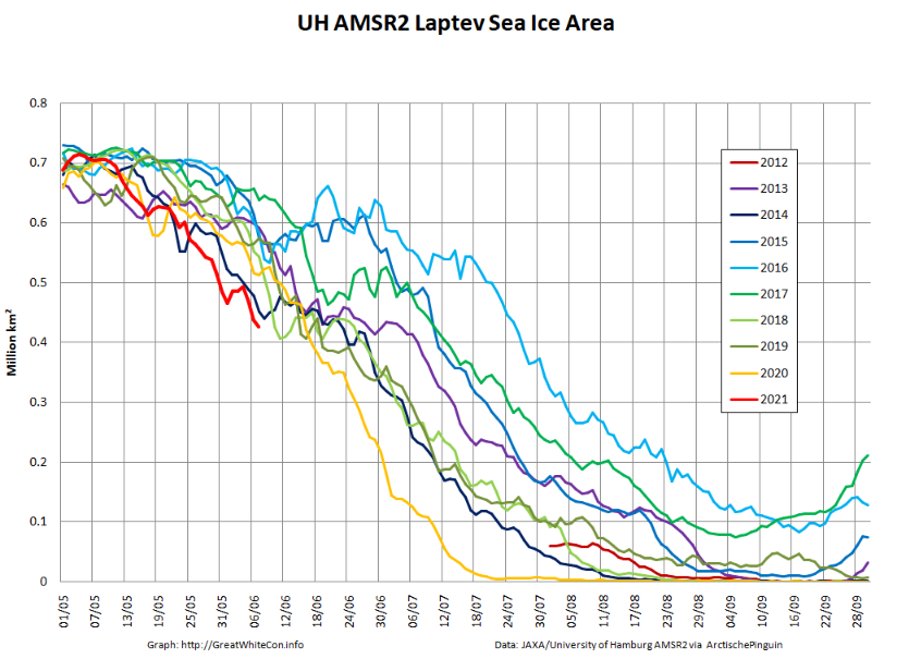
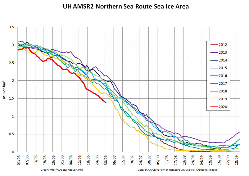
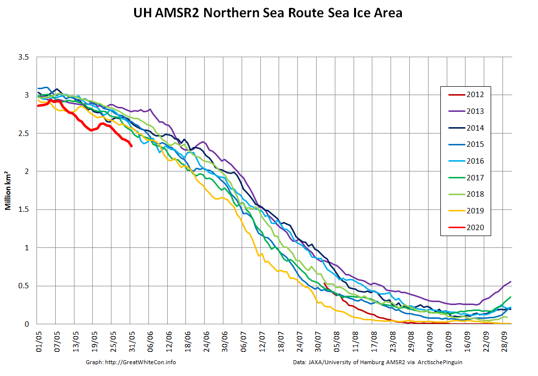
However following the extremely warm spring in Siberia, the sea ice area along the assorted sea that comprise the Northern Sea Route is well below all previous years in the AMSR2 record:

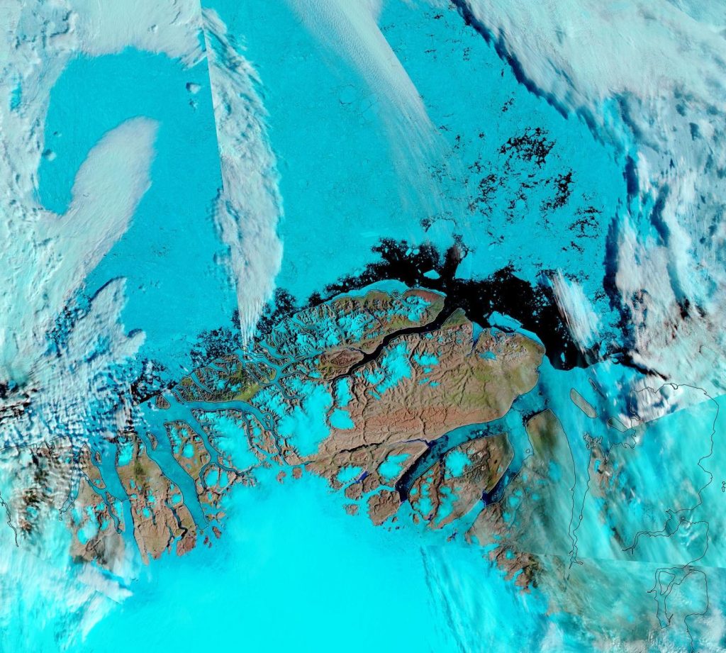
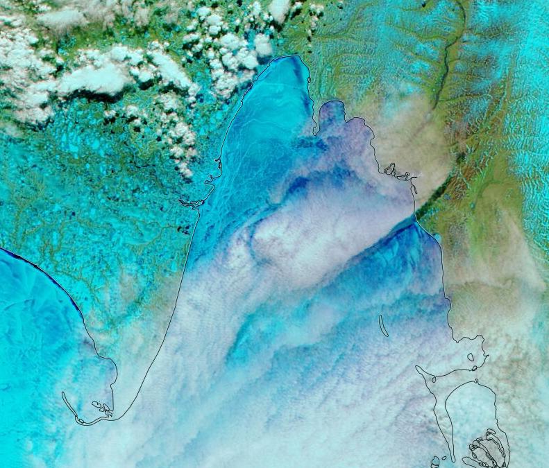
Another effect of the sweltering Siberian spring is evident in the melt ponds visible below the clouds across the southernmost parts of the Laptev Sea:

NASA Worldview “false-color” image of the Laptev Sea on June 1st 2020, derived from the MODIS sensor on the Aqua satellite

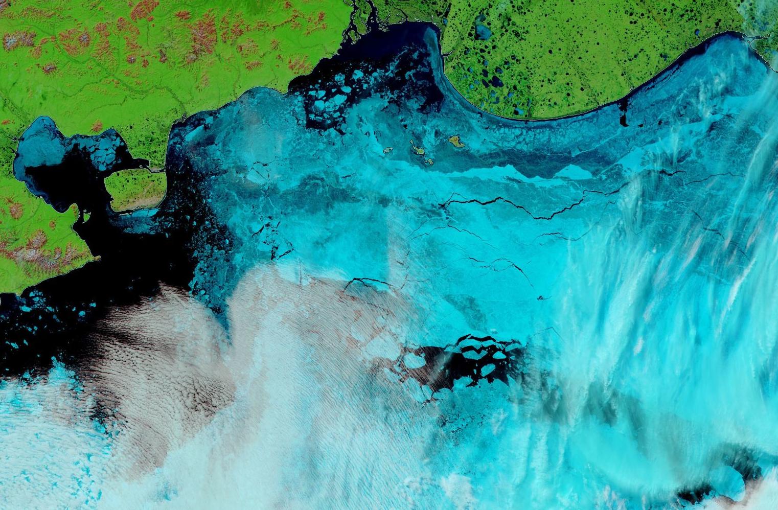
plus the East Siberian Sea and Chaunskaya Bay:

NASA Worldview “false-color” image of the East Siberian Sea on June 1st 2020, derived from the MODIS sensor on the Terra satellite

[Edit – June 4th]

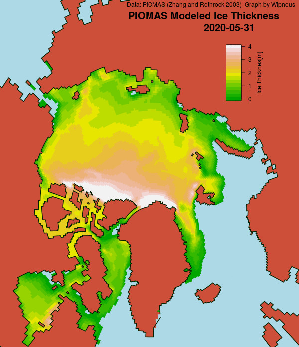
The May 31st PIOMAS gridded thickness numbers have been released, and Wipneus has crunched the numbers:

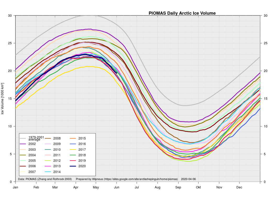
Here too is the latest volume graph:

According to the Polar Science Center’s May 2020 update:

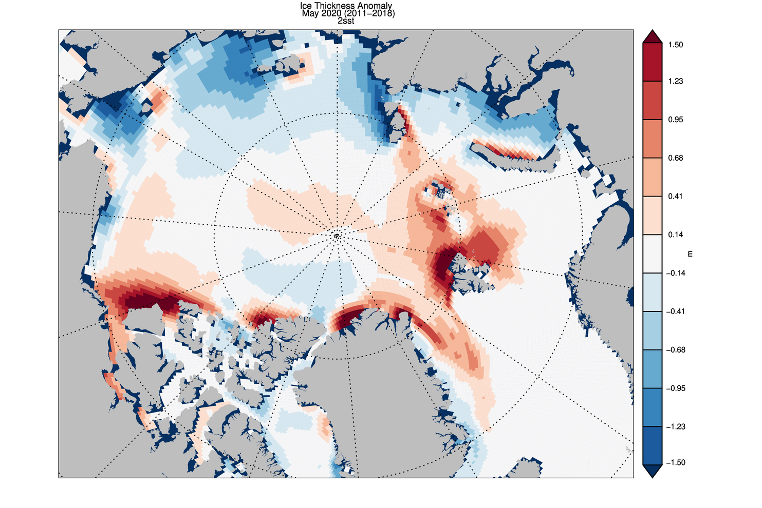
Average Arctic sea ice volume in May 2020 was 21,500 km3. This value is 1700 km3 above the record minimum value of 19,800 km3 set in 2017, making it the sixth lowest on record. Monthly ice volume was 39% below the maximum in 1979 and 25% below the mean value for 1979-2019. May 2020 ice volume falls 0.8 standard deviations above the trend line. Daily volume anomalies for May progressed at a fairly normal pace for recent years. Average ice thickness is in the middle of the pack for the more recent years. Ice thickness anomalies for May 2020 relative to 2011-2018 continue the April pattern and show relatively thin ice along the Russian Coast and thicker than normal sea ice in the Barents sea. There are some fairly strong positive anomalies in the eastern Beaufort and north of Greenland. This anomaly pattern is likely due to the very strong positive Arctic-Oscillation index pattern that occurred during the Winter of 2020.

There looks to be a lot of anomalously thick ice waiting to melt out on the Atlantic periphery, and it will be interesting to see how the thicker ice in the eastern Beaufort Sea fares as the melting season progresses.

As also suggested by the area graph above, the Northern Sea Route is going to be open early in 2020. In fact a ice hardened tanker has already begun its journey through, unsupported by an icebreaker:

It was the “Christophe de Margerie” that on the 19th May kickstarted this year’s shipping season across the eastern part of the Northern Sea Route. The vessel owned and operated by Russian shipping company Sovcomflot loaded up liquefied natural gas in Sabetta and is due to arrive in the Chinese port of Jingtang on the 11th June. It was the earliest east-bound shipment on the route ever for this kind of vessel.

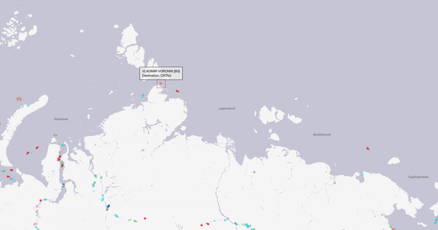
Shipments in the Northern Sea Route 27th May 2020. Map by MarineTraffic

By 27th May, the ship had made it almost to Wrangel Island, information from ship tracker service MarineTraffic shows. The “Christophe de Margerie” is accompanied by nuclear powered icebreaker “Yamal”.

In the wake of the almost 300 meter long vessel now follows the “Vladimir Voronin”, a vessel that is operated by company Teekay. The “Vladimir Voronin” on the 25th May left Sabetta and was on May 27th located in the Vilkitsky Strait north of the Taymyr Peninsula.

The ”Vladimir Voronin” is not accompanied by icebreaker. The “50 Let Pobedy” that escorted the ship out of Sabetta and eastwards towards the Vilkitsky Strait has now returned and appears to be on its way back to Sabetta.

[Edit – June 17th]

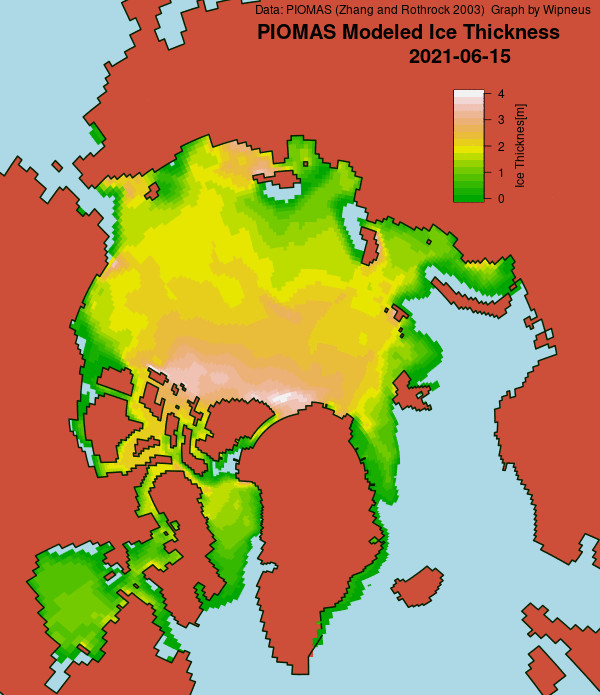
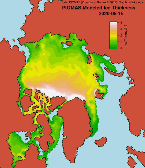
The mid month PIOMAS gridded thickness numbers have just been released. Here’s the thickness map:

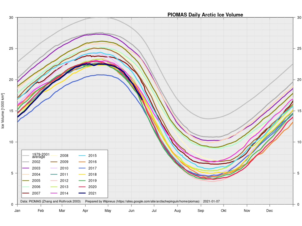
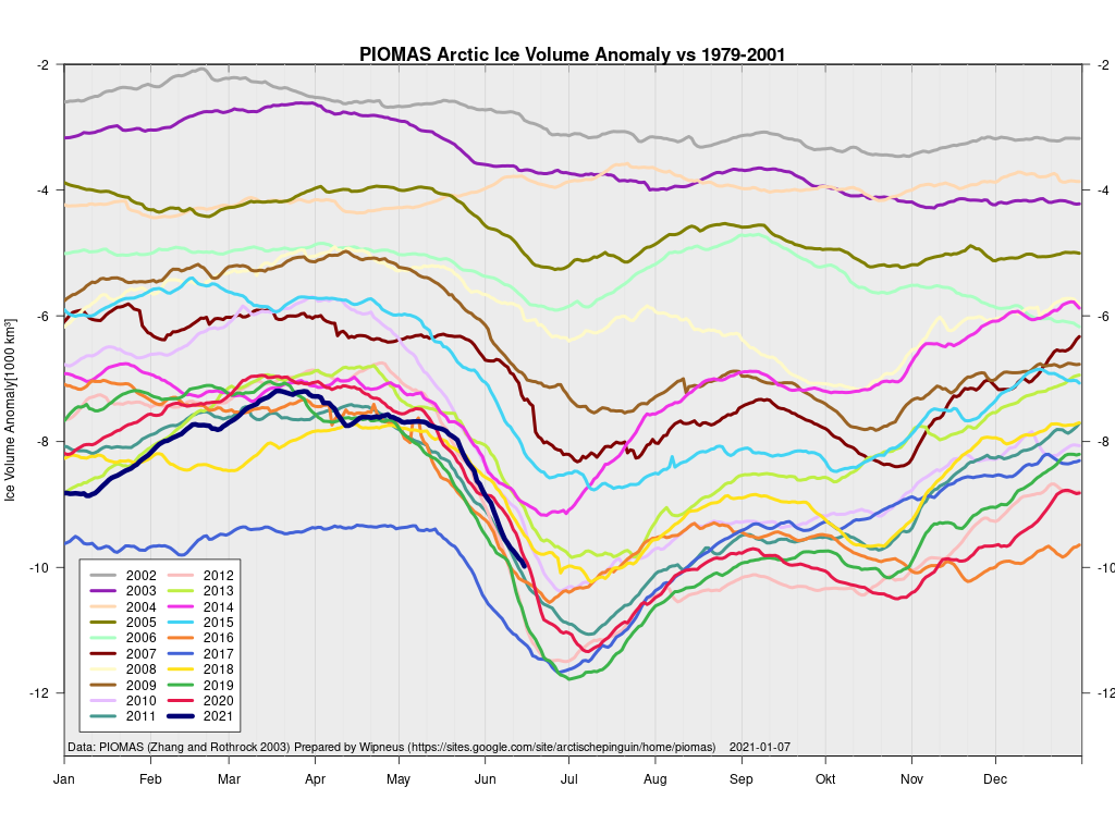
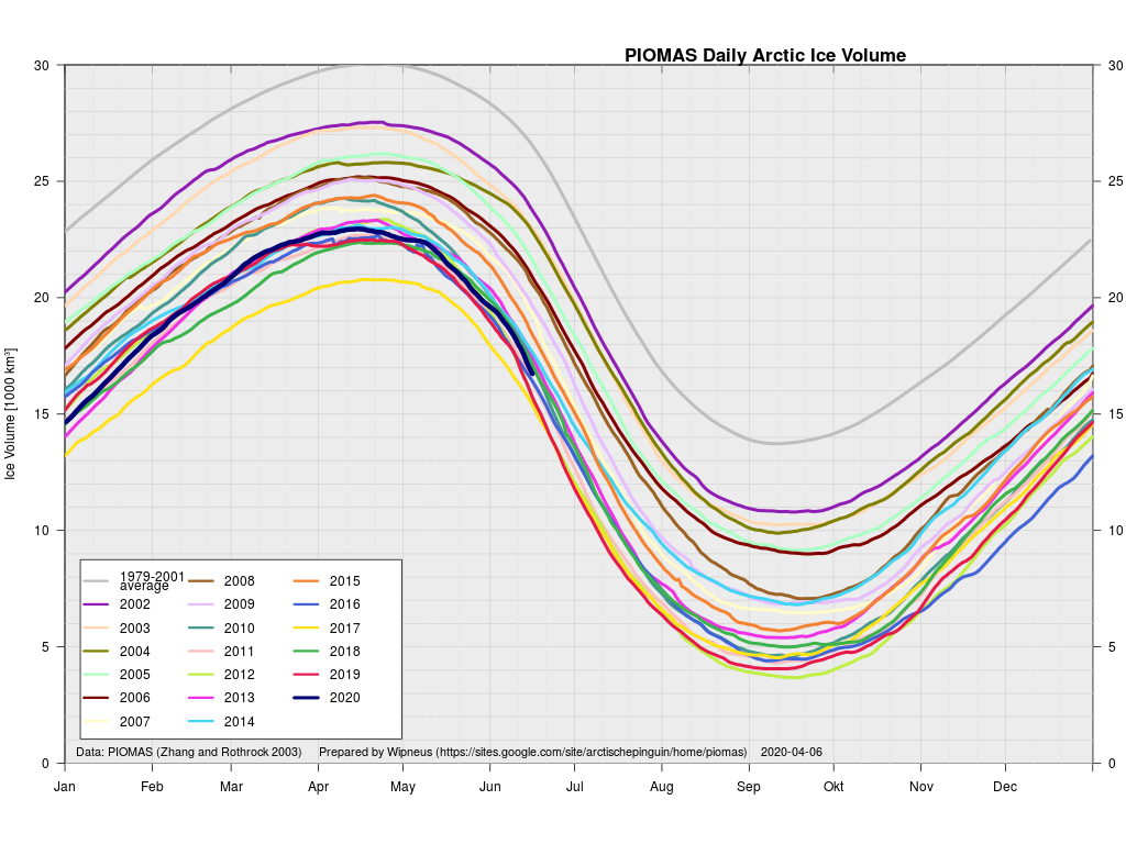
and the volume graph:

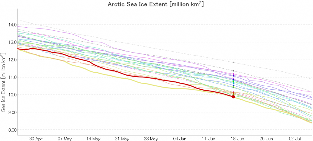
In addition JAXA extent is now in a “statistical tie” with 2019 in the “lowest for the date” competition:

Watch this space!
Facts About the Arctic in May 2020

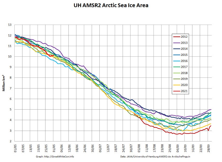
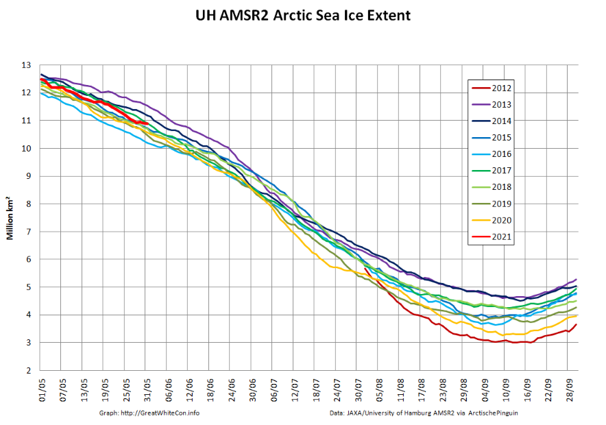
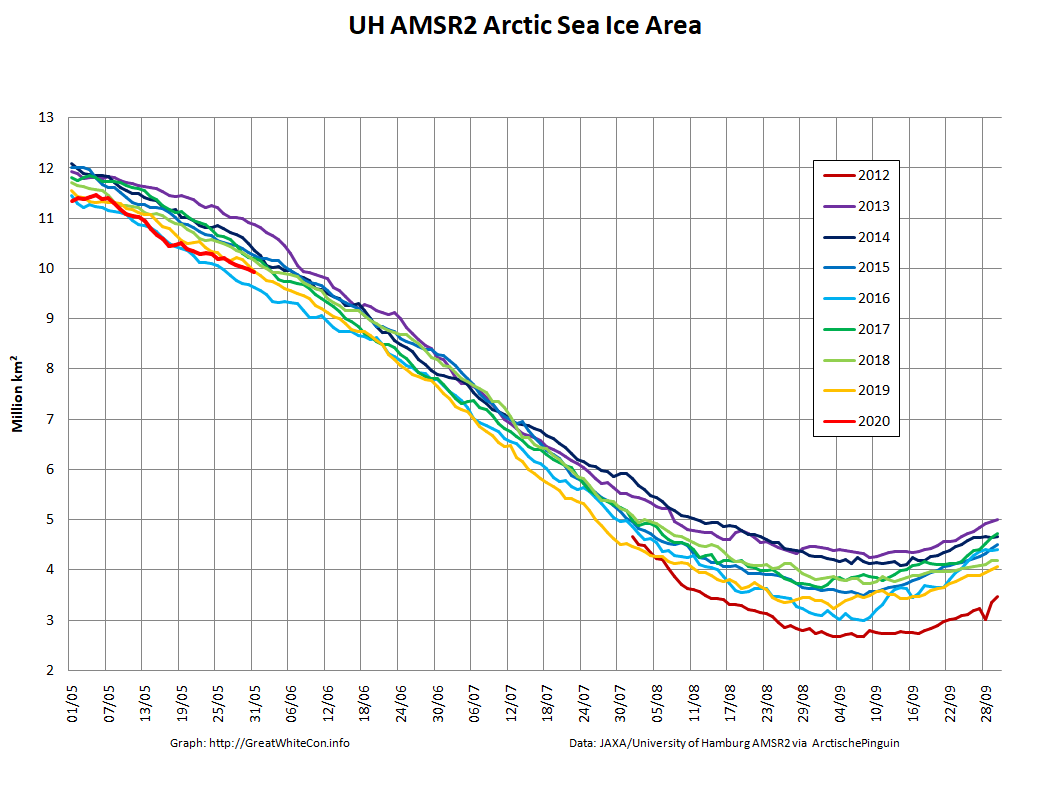
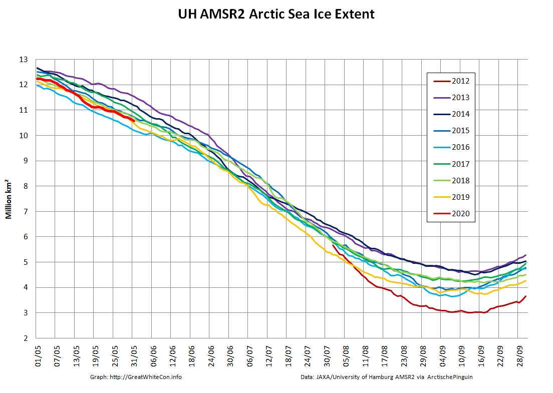
Let us begin this month’s report from the far north with the high resolution Arctic sea ice area and extent graphs based on the University of Hamburg’s AMSR2 concentration maps:

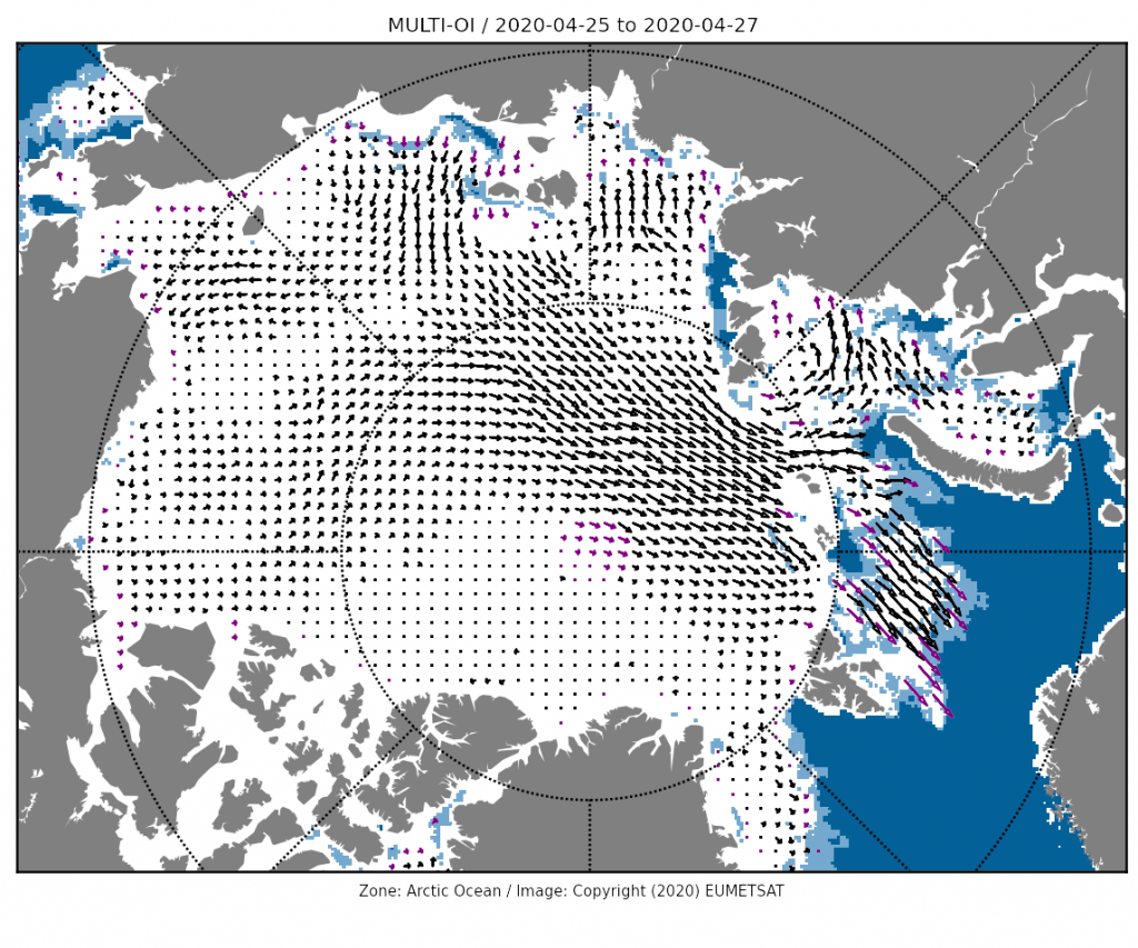
Area is currently lowest for the date in the AMSR2 record. After briefly occupying that position extent has increased over the last few days of April due to winds causing sea ice to move in the direction of the far North Atlantic:


The Alfred Wegener Institute has now finished reanalysing their CryoSat-2/SMOS thickness data, and the resulting volume graph looks like this:

“Measured” Arctic sea ice volume is the lowest in the CryoSat-2 era as we head towards the main 2020 melting season, which in my calendar at least begins on June 1st. The PIOMAS modelled volume numbers should be released shortly.

[Edit – May 5th]

The April 30th PIOMAS gridded thickness numbers have been released, and Wipneus has worked his usual magic. By way of comparison with the AWI metric:

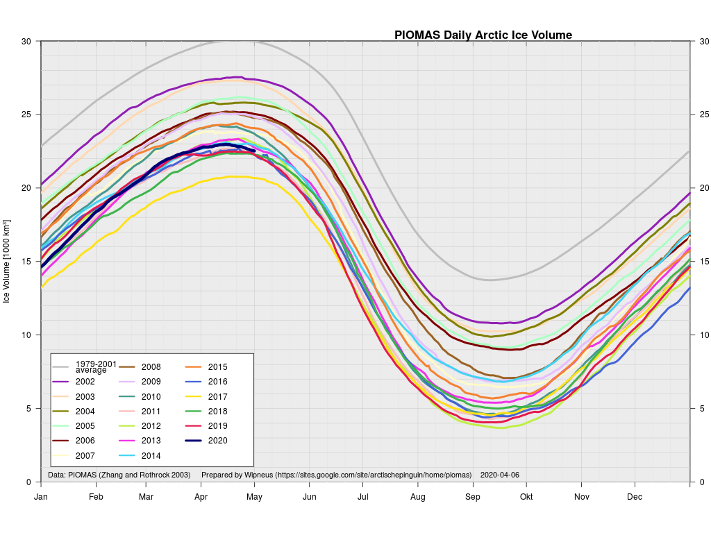
Obviously differing from CryoSat-2/SMOS, PIOMAS has 2020 volume a long way above 2017, in amongst a gaggle of other years.

[Edit – May 13th]

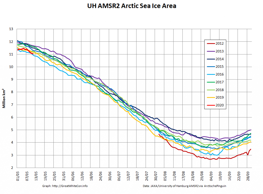
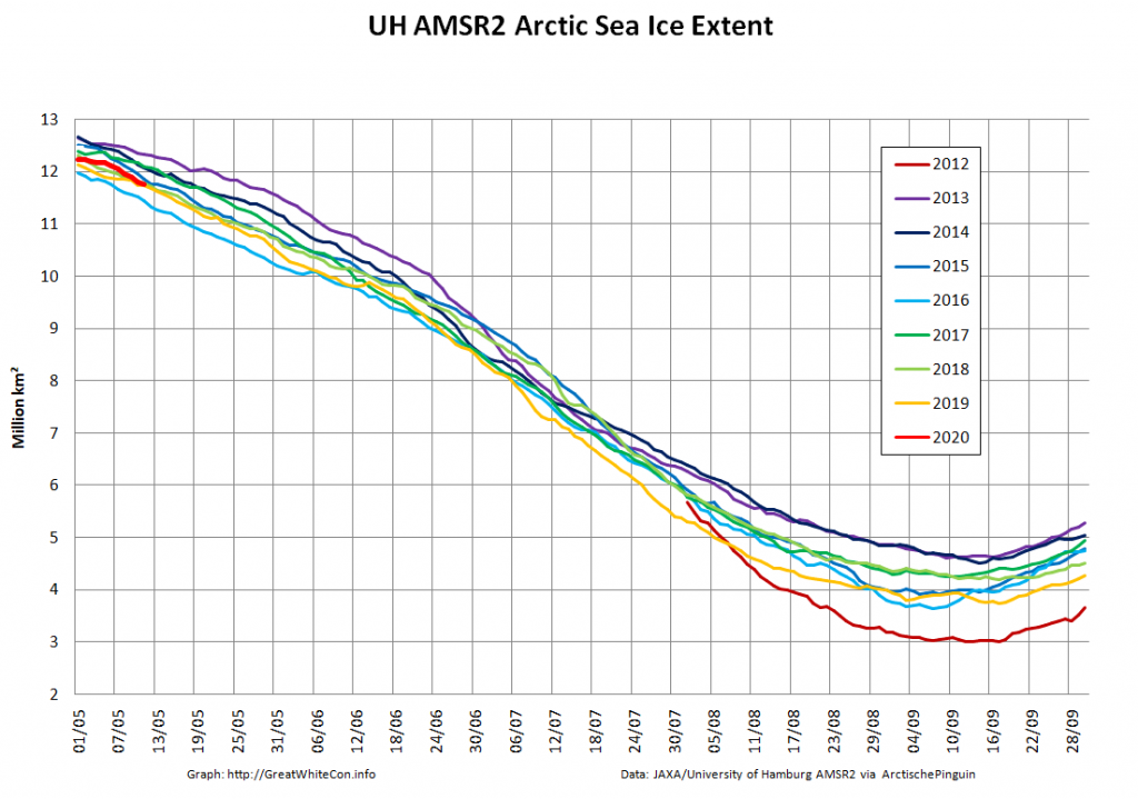
The middle of May is rapidly approaching, so let’s start to set the scene for the forthcoming melting season. First off here are the hi res AMSR2 area and extent graphs:

Extent is currently significantly above 2016 due to the recent “dispersion” mentioned above, but area is very close to an all time low for the date.

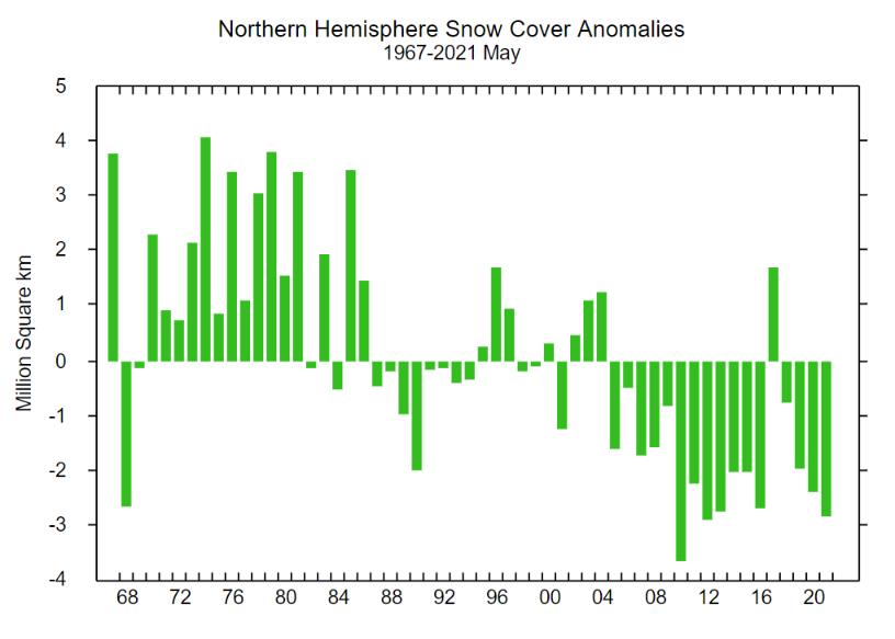
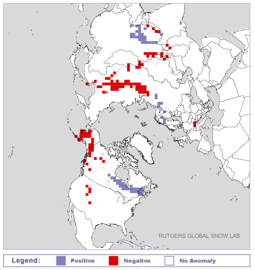
Next take a look at the current northern hemisphere snow cover anomalies from the Rutgers University Snow Lab:

Whilst there is a positive anomaly near Hudson Bay, there are significant negative anomalies across Siberia and Alaska. This does not augur well for sea ice retention along both the Northern Sea Route and Northwest Passage by September 2020.

Watch this space!
Facts About the Arctic in April 2020

This comes to you a couple of days early, but the clocks have just changed to British Summer Time in the once United Kingdom and there is news to impart.

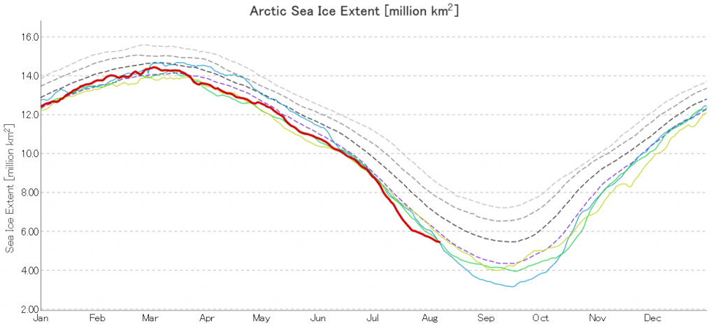
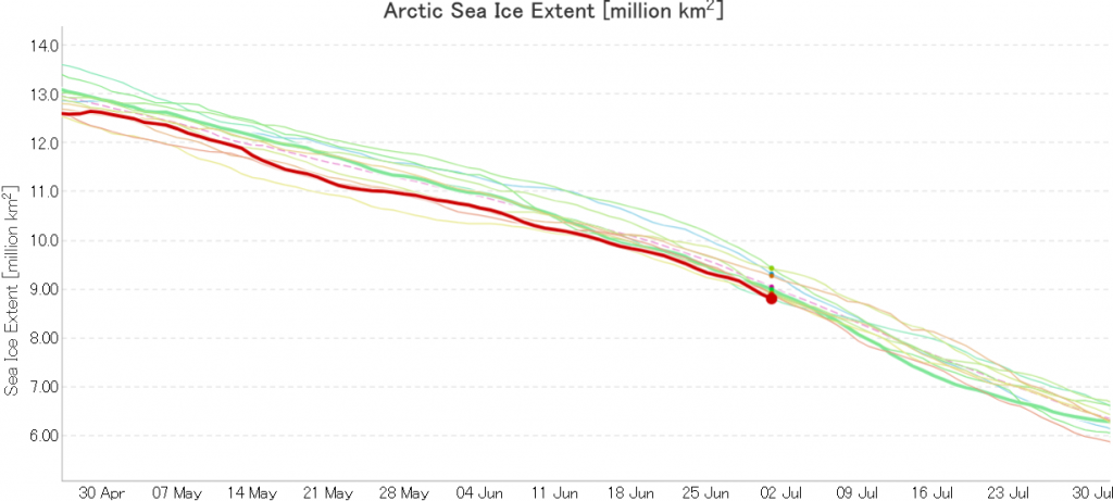
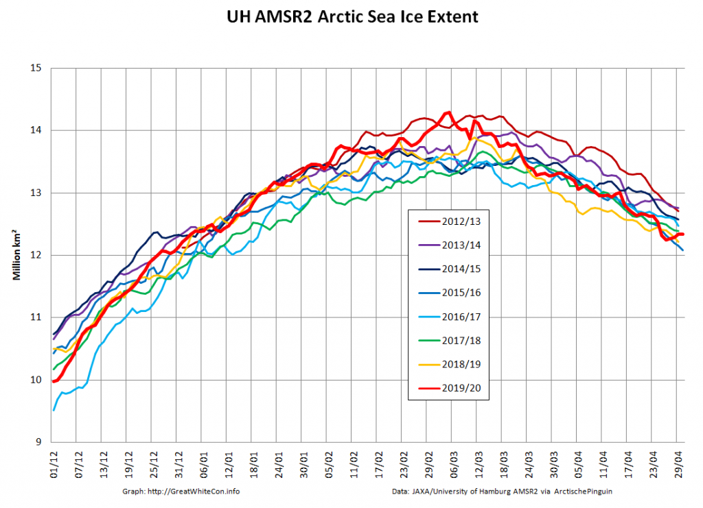
JAXA Arctic sea ice extent has fallen to the lowest level for the date in their satellite era records going back to 1979. This graph shows every year since 2000:

The high resolution AMSR2 regional graphs make clear that the precipitous drop on the Pacific periphery has continued:

The current combined SMOS/SMAP Arctic sea ice “thinness” map makes clear that there is plenty more thin ice ready for melting in the Sea of Okhotsk and Baffin Bay:

There is also a large area of thin ice in the Laptev Sea, which will be interesting to watch once the 2020 melting season gets underway in earnest.

[Edit – April 1st]

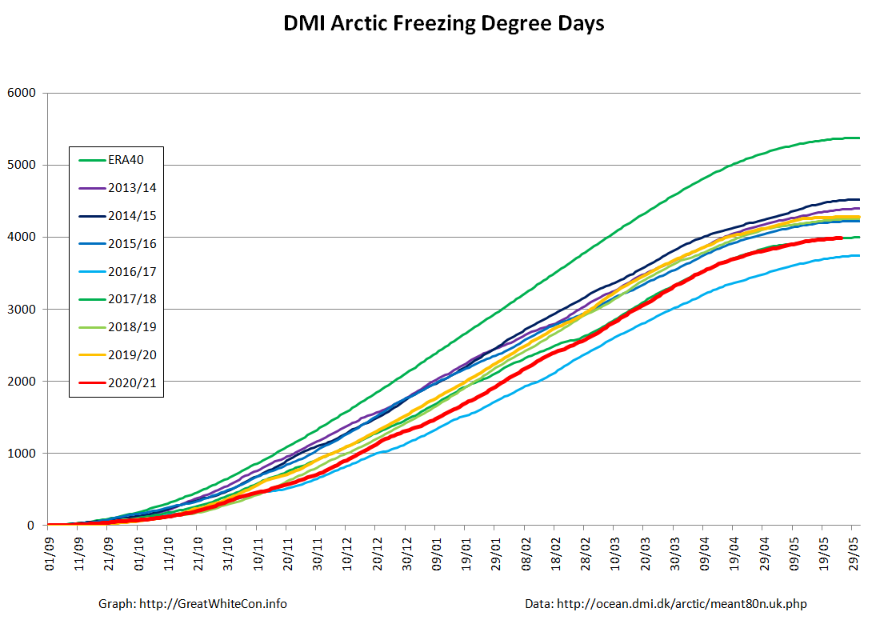
Today is All Fools’ Day, but this is no joke. Thanks to the consistent polar vortex over the Northern Hemisphere winter there is currently an anomalous “ozone hole” over the North Pole. As recently described in Nature:

A vast ozone hole — probably the biggest on record in the north — has opened in the skies above the Arctic. It rivals the better-known Antarctic ozone hole that forms in the southern hemisphere each year.

Record-low ozone levels currently stretch across much of the central Arctic, covering an area about three times the size of Greenland. The hole doesn’t threaten people’s health, and will probably break apart in the coming weeks. But it is an extraordinary atmospheric phenomenon that will go down in the record books.

“From my point of view, this is the first time you can speak about a real ozone hole in the Arctic,” says Martin Dameris, an atmospheric scientist at the German Aerospace Center in Oberpfaffenhofen.

Here are the latest graphics from the “Arctic Ozone Watch” section of the NASA web site:

Observations made during the still ongoing MOSAiC expedition, have confirmed the satellite derived measurements:

This year, powerful westerly winds flowed around the North Pole and trapped cold air within a ‘polar vortex’. There was more cold air above the Arctic than in any winter recorded since 1979, says Markus Rex, an atmospheric scientist at the Alfred Wegener Institute in Potsdam, Germany. In the chilly temperatures, the high-altitude clouds formed, and the ozone-destroying reactions began.

Researchers measure ozone levels by releasing weather balloons from observing stations around the Arctic (including the Polarstern icebreaker, which is frozen in sea ice for a year-long expedition). By late March, these balloons measured a 90% drop in ozone at an altitude of 18 kilometres, which is right in the heart of the ozone layer. Where the balloons would normally measure around 3.5 parts per million of ozone, they recorded only around 0.3 parts per million, says Rex. “That beats any ozone loss we have seen in the past,” he notes.

I’ve previously conjectured about the potential effect of the strong polar vortex on Northern Hemisphere snow cover this Spring, and here’s NOAA’s current snow extent graph:

JAXA extent’s precipitous recent decline has abated, and it’s now 5th lowest for the date in the satellite era:

[Edit – April 4th]

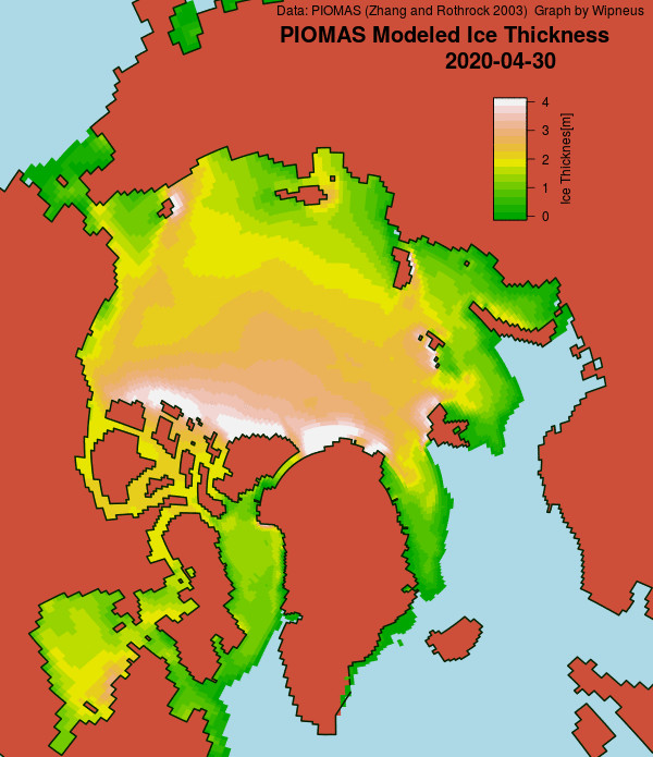
Here’s the March 31st PIOMAS Arctic sea ice gridded thickness map:

together with the traditional volume graph:

Wipneus comments on the Arctic Sea Ice Forum that:

Ice is thickening impressively against the Canadian Archipelago and North Greenland.

That is indeed the case with the PIOMAS “modelled” numbers, but is much less obvious in the latest CryoSat-2/SMOS “measured” thickness map where ice over 4 metres thick is still conspicuous by its absence North of Greenland:

Plus a bonus graph for “Turbulent Eddie”, who suggests that:

[There’s] not much thick ice on the East Coast of Greenland, indicating the increase was from reduced loss through the Fram Strait?

together with the latest AARI ice age map:

[Edit – April 6th]

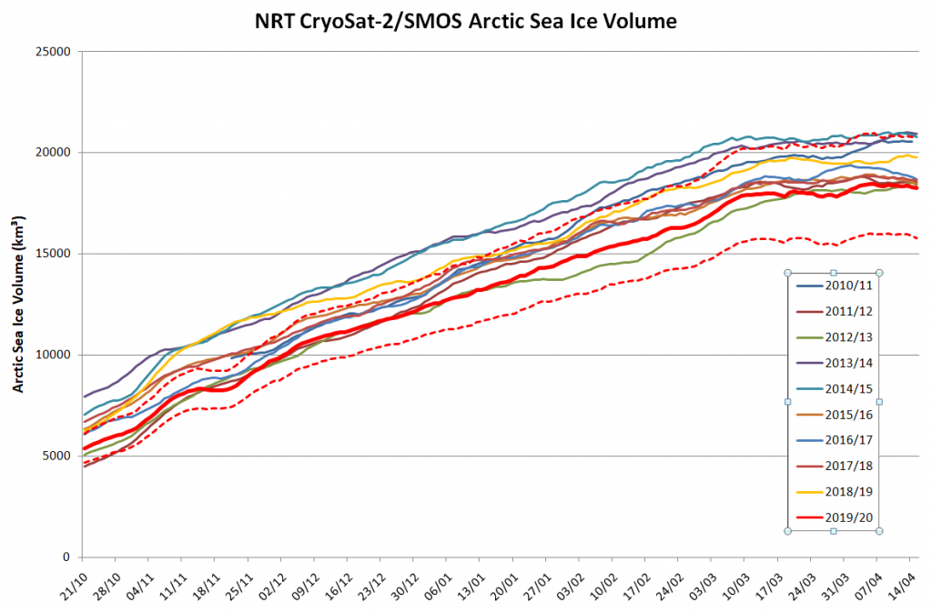
Here’s the latest update of our novel NRT volume metric:

I’ve applied a crude correction to the still problematic NRT data so that it at least coincides with the reanalysed data on March 14th. Whilst we await the reanalysed numbers for the rest of March and early April it looks as though Arctic sea ice volume reached at least a temporary peak on March 20th 2020.

[Edit – April 19th]

Here’s another update of our novel NRT volume metric, still incorporating my “fudge factor”:

Note also this handy hint from Stefan Hendricks on Twitter:

[Edit – April 21st]

Wipneus has crunched the mid month PIOMAS gridded thickness numbers. Here’s the result:

The discrepancy between the PIOMAS model and the CryoSat-2 “reality” is still very evident.

[Edit – April 25th]

With another week’s worth of reanalysed data now processed, it now seems certain that the CS2/SMOS Arctic sea ice volume maximum was 18469 km³ on April 6th:

[Edit – April 28th]

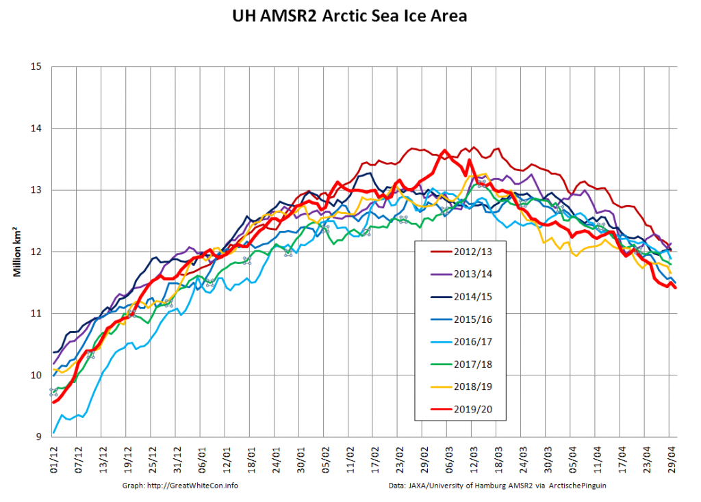
The high resolution AMSR2 area and extent metrics are now both “lowest for the date” in the AMSR2 record:

JAXA/ViSHOP AMSR2 extent isn’t quite there yet: