Tag Archives: Age

Facts About the Arctic in May 2022

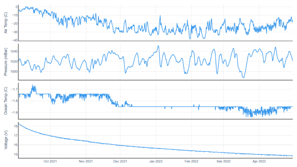
By way of a change we’ll start the month of May with a closer look at one of the ice mass balance buoys deployed in the Beaufort Sea last Autumn. IMB buoy 569620 was deployed at 78.5 N, 147.0 W on September 3rd 2021, and since then it has drifted to 81.0 N, 147.7 W. Here is the buoy’s record of atmospheric conditions above the ice floe it’s embedded in since then:
Here too is the buoy’s record of the temperature of the ice floe itself, as well as the thickness of the ice and the snow layer covering it:
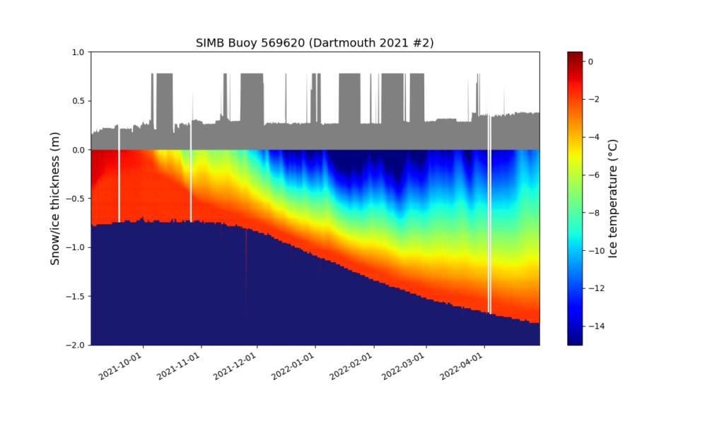
There’s a few things to note at first glance. The ice floe continued to decrease in thickness into November. It’s thickness then started to increase, but is currently still less than 2 meters. Also the snow depth has gradually been increasing, and (apart from some data glitches!) is now ~38 cm. Finally, for the moment at least, the ice surface temperature has been slowly warming since mid February and is now ~-11 °C.

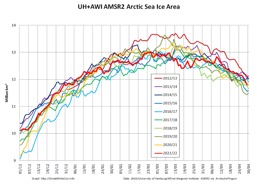
Returning to more familiar territory, high resolution AMSR2 Arctic sea ice area has taken a bit of a tumble recently:
followed less steeply by extent:
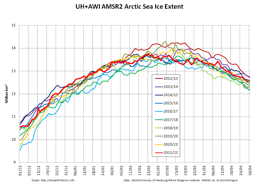
Not unexpectedly, the Pacific periphery is currently leading the decline:
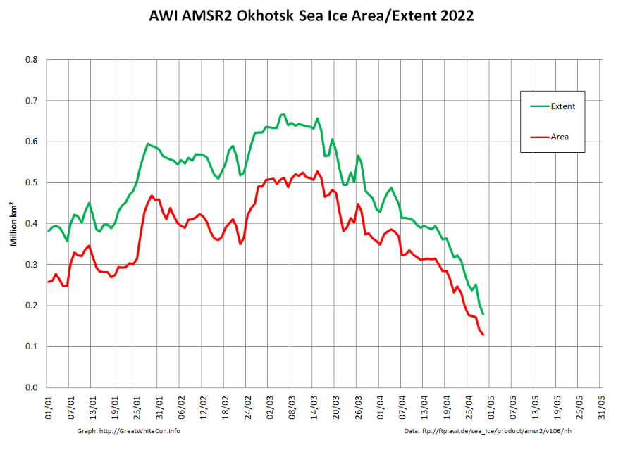
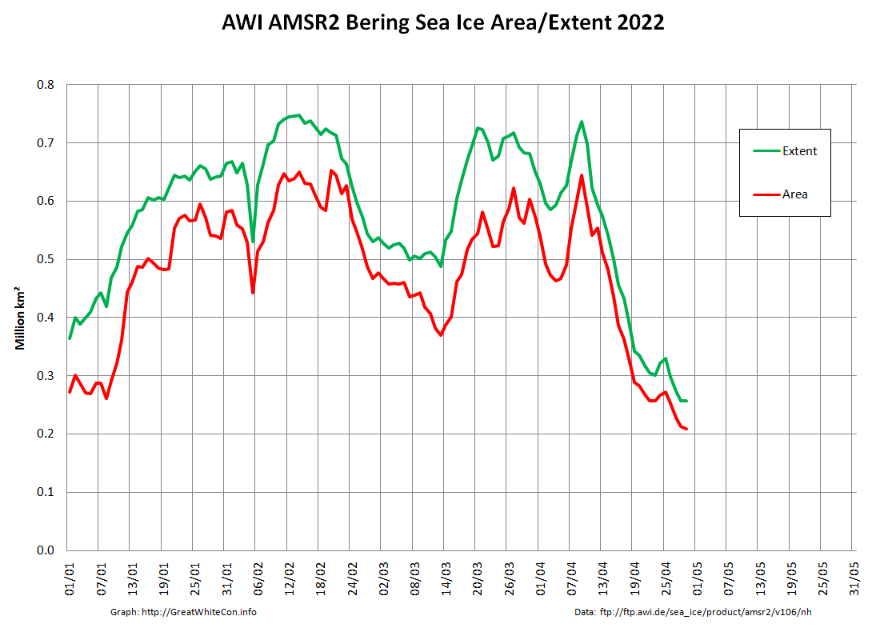
[Edit – May 4th]

The Rutgers Snow Lab has updated its northern hemisphere snow cover bar chart for April 2022:

The May edition of the NSIDC’s Arctic Sea Ice News has also just been published. It summarises April 2022 as follows:

Average Arctic sea ice extent for April 2022 was 14.06 million square kilometers (5.43 million square miles). This was 630,000 square kilometers (243,000 square miles) below the 1981 to 2010 average and ranked eleventh lowest in the 44-year satellite record.

Extent declined slowly through the beginning of the month, with only 87,000 square kilometers (33,600 square miles) of ice loss between April 1 and April 10. The decline then proceeded at an average pace for this time of year through the reminder of the month.
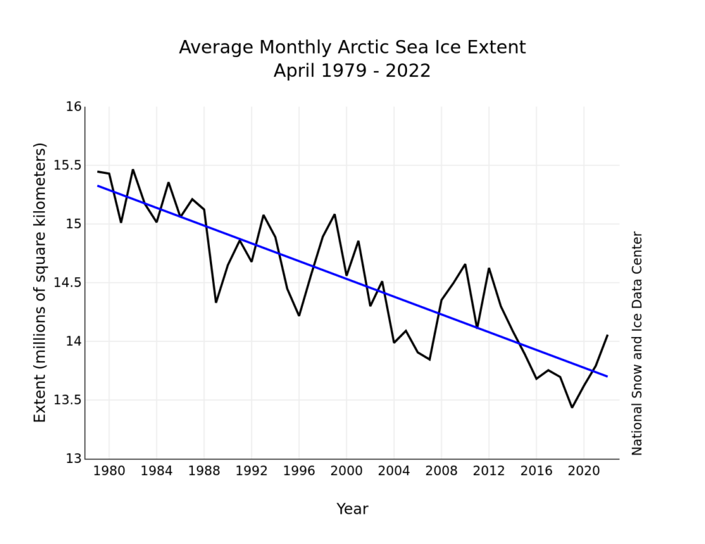
During April, temperatures at the 925 mb level (about 2,500 feet above the surface) over the Arctic Ocean were above average. Most areas were 2 to 3 degrees Celsius (4 to 5 degrees Fahrenheit) above average, but in the Beaufort Sea, April temperatures were up to 5 to 6 degrees Celsius (9 to 11 degrees Fahrenheit) above average:
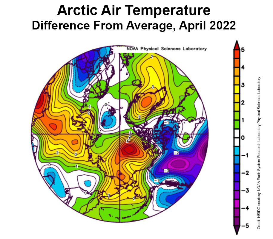
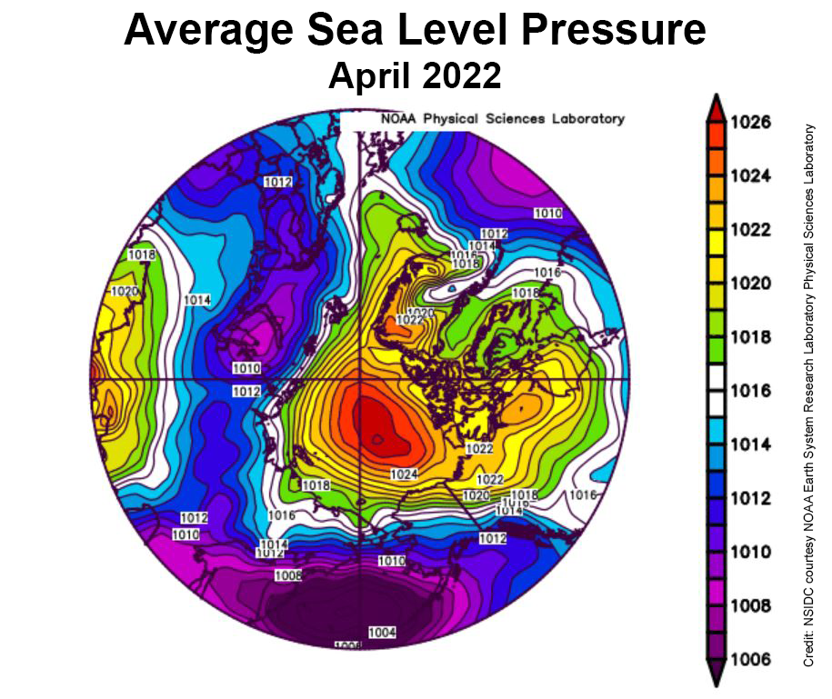
This was accompanied by a strong Beaufort High pressure cell through the month:
The NSIDC’s update also refers to the Chukchi Sea polynya we’ve been keeping an eye on here:

Strong offshore winds over the northwest coast of Alaska led to openings in the ice cover, called polynyas. The first pulse of winds began on March 21. At that time, surface air temperatures were still well below freezing, and the water in the coastal polynya quickly refroze. By April 9, the offshore push of the ice ceased and the polynya iced over completely.

However, starting on April 12, a second round of offshore wind pushed the ice away from the coast, initiating another polynya. Refreezing began anew in the open water areas, but the ice growth was noticeably slower, reflecting the higher surface air temperatures by the end of the month

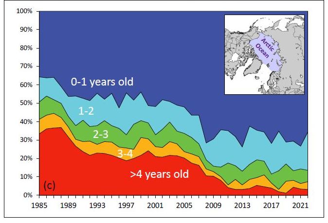
The NSIDC also updated their graph of sea ice age, on this occasion for the week of March 12th to 18th over the years:
Arctic sea ice news concludes with brief news of the recent death of Canadian Arctic scientist David Barber. CBC News’s obituary for David provides more details:

Family and friends are mourning the loss of the visionary Arctic researcher and University of Manitoba professor David Barber.

Barber, who was a distinguished professor, the founding director of the Centre for Earth Observation Science and  associate dean of research in the faculty of environment, earth and resource, passed away on Friday after suffering complications from cardiac arrest.

Barber, 61, is survived by his wife Lucette, three children and two grandchildren.
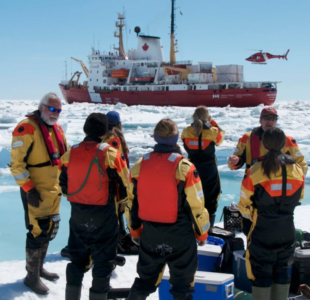
David Barber (left) pictured with his team on an Arctic expedition.  Photo: Julien Barber

[Edit – May 9th]

The waters of the Mackenzie River are starting to spread over the fast ice off the delta:
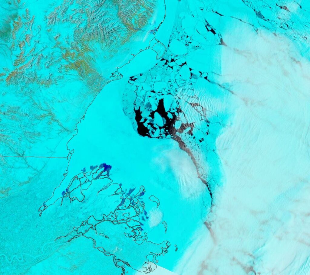
“False colour” image of the Beaufort Sea on May 7th from the MODIS instrument on the Terra satellite

[Edit – May 11th]

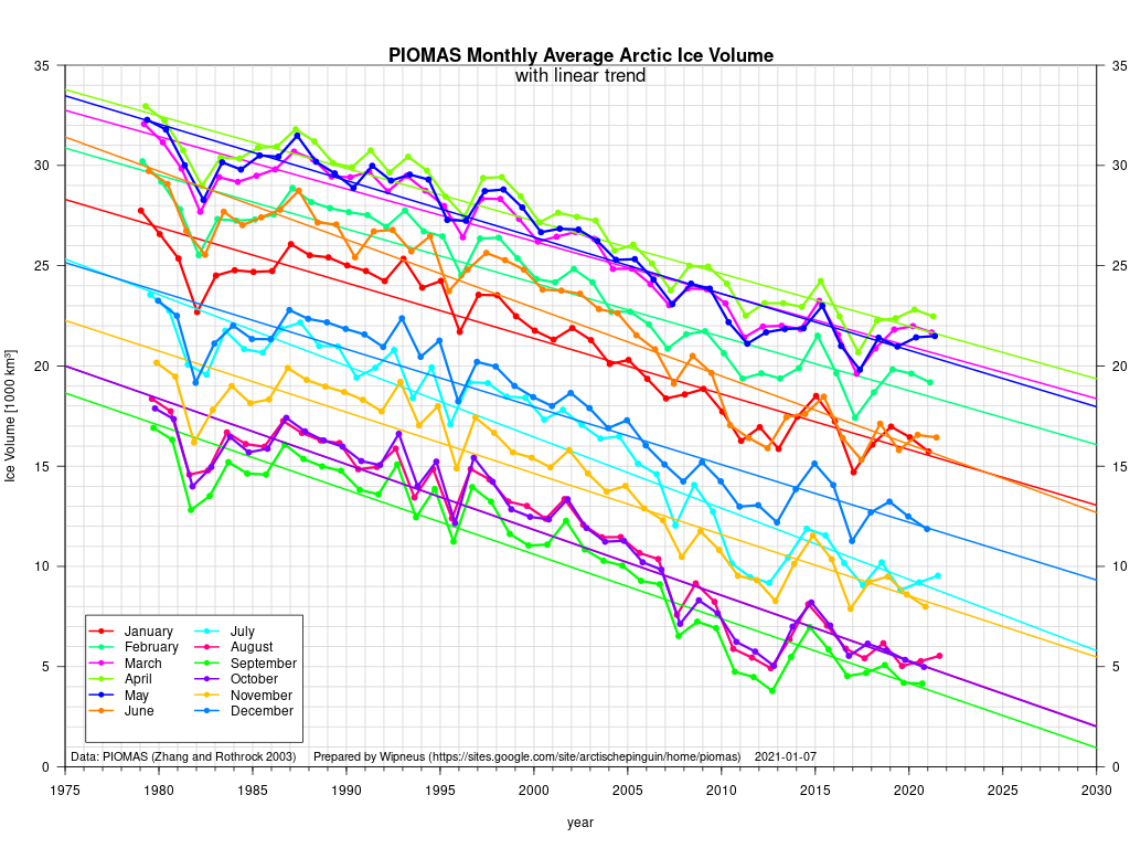
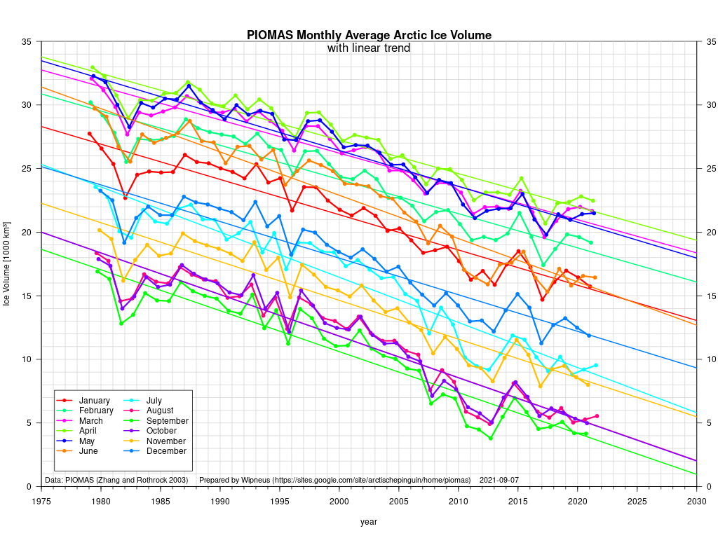
The Polar Science Center at the University of Washington has released the PIOMAS volume data for April 2022:

Average Arctic sea ice volume in April 2022 was 23,000 km3. This value is the 9th lowest on record for April, about  2,300 km3 above the record set in 2017.   Monthly  ice volume was 30% below the maximum in 1979 and 15% below the mean value for 1979-2021. Average April 2022 ice volume was 1.45 standard deviations above the 1979-2021 trend line.
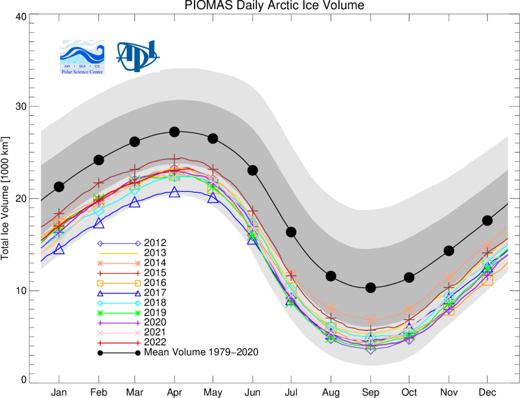
The daily volume numbers reveal the PIOMAS maximum volume for 2022 to be 23,225 km3 on April 26th.

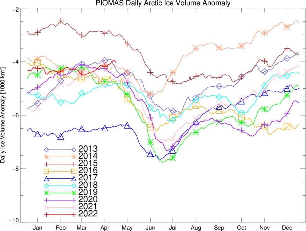
The PSC report continues:

Ice growth anomalies for April 2022 continued to be at the upper end of the most recent decade with a mean ice thickness (above 15 cm thickness) at the middle of recent values.
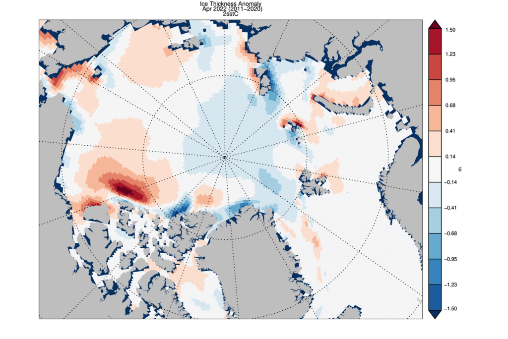
The ice thickness anomaly map for April 2022 relative to 2011-2020 divides the Arctic in two halves with positive anomalies in the “Western Arctic”  but negative anomalies in “Eastern Arctic”. A narrow band of negative anomalies remains along the coast of North Greenland but a positive anomaly exists north of Baffin Island.
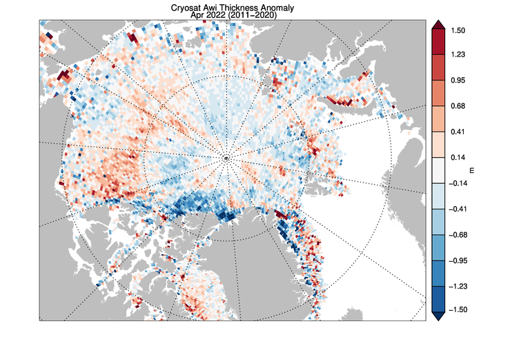
Note that the “positive anomaly north of Baffin Island” referred to is not apparent in the CryoSat 2 ice thickness anomaly map, although there is agreement about the thicker ice in the eastern Beaufort Sea:
[Edit – May 23rd]

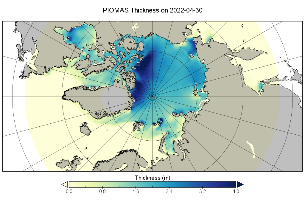
CryoSat-2 thickness maps stopped for the Summer in mid April. I’ve been hoping for mid May data from the PIOMAS team, but in vain so far. In its continuing absence here is a “work in progress” PIOMAS thickness map for the end of April:
The sea ice in Chaunskaya Bay and along the adjacent coast of the East Siberian Sea is starting to look distinctly damp:
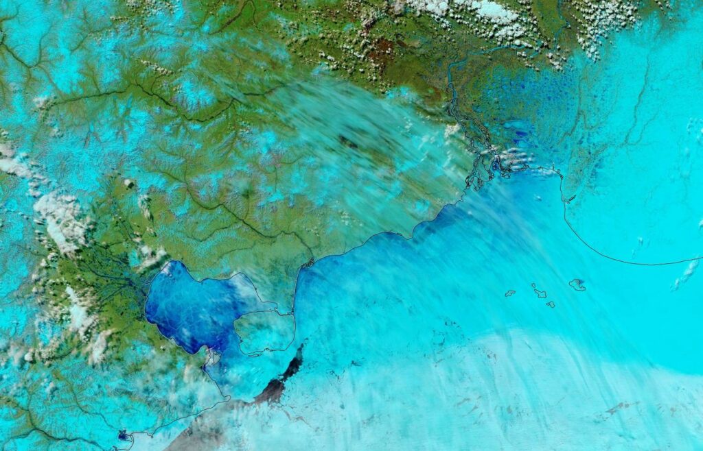
“False colour” image of the East Siberian Sea on May 23rd from the MODIS instrument on the Terra satellite

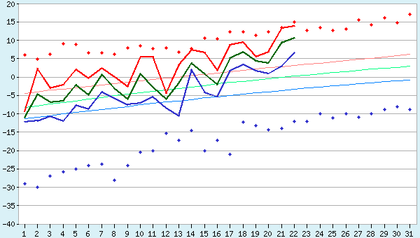
That’s not too surprising when you also look at recent temperatures in Pevek, which have been approaching all time highs for the date:
P.S. The Mackenzie River has reappeared from under the clouds and is now largely liquid:
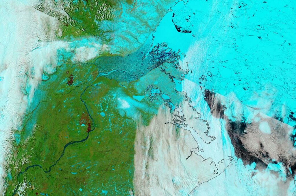
“False colour” image of the Mackenzie River and Beaufort Sea on May 23rd from the MODIS instrument on the Terra satellite

[Edit – May 27th]

Some surface melt is now visible on the fast ice at Utqiaġvik:
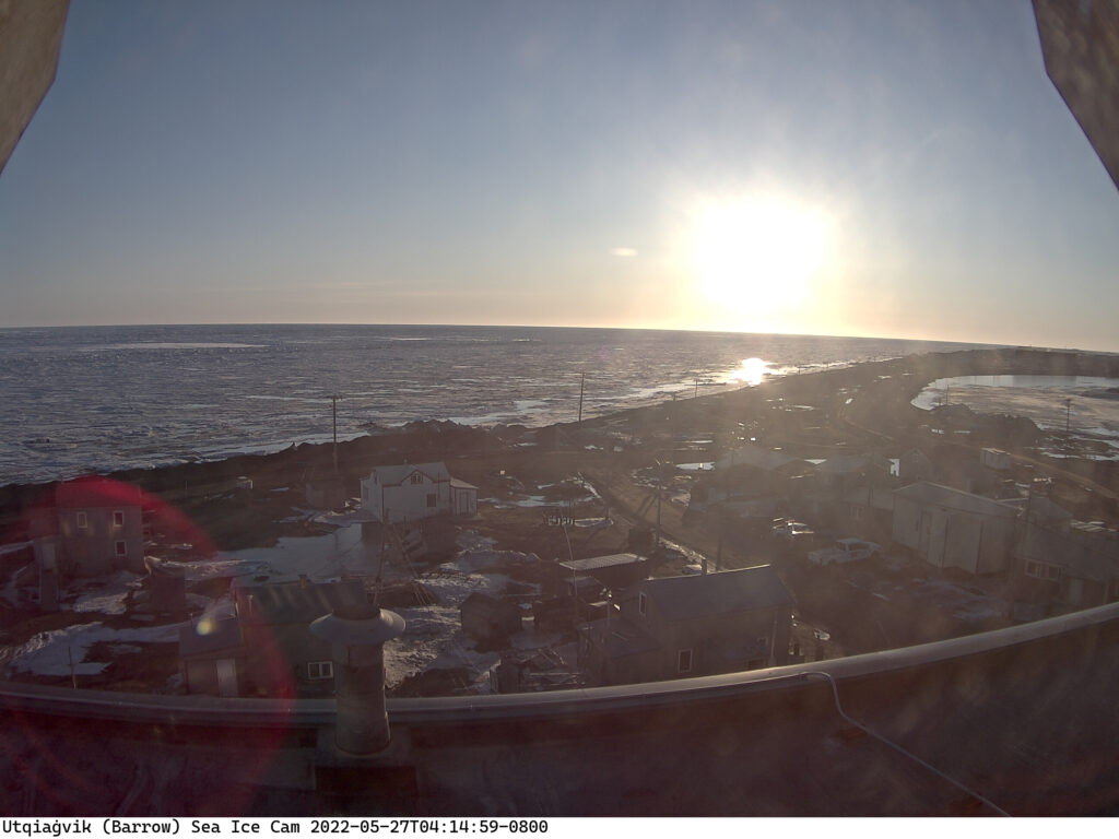
No doubt the recent above zero temperatures are responsible, but the forecast is for colder conditions to return:

Discussion continues on the new open thread for June 2022.

Facts About the Arctic in October 2021

By way of a change we start this month’s look at all things Arctic with some sea ice statistical analysis. Anthony Watts’ Arctic porky pie production line has been speeding up recently, and I am not the only one who has noticed. As part of his takedown of the latest “skeptical” allegations against the United Kingdom Met Office Tamino has been looking at trends in Arctic sea ice extent over at his “Open Mind” blog:

First and foremost, the yearly minimum is only one day out of the year. We have sea ice extent data throughout the year, and what happens during the rest of the year counts. Instead of using the annual minimum, let’s use the annual average. To avoid losing the most recent data, I’ll compute the yearly average for October through the following September rather than the usual (but arbitrary) January through December. I’ll also omit October 1978 through September 1979 because that year is incomplete. I get this:

The annual averages show much less fluctuation than the annual minima, so we can estimate things like rates of change with greater precision. I find that there is statistical evidence that the rate changed over time. One model of such changes uses three straight-line segments with their changes chosen to best-fit the data, like this:

Continue reading Facts About the Arctic in October 2021

ICESat-2 2021 Sea Ice Thickness

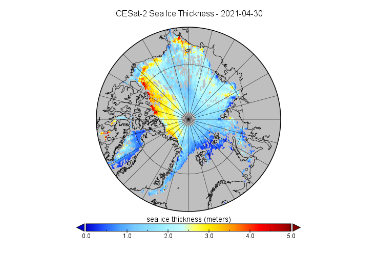
We reported on the first ICESat-2 sea ice thickness data to be released back in May. We are now very pleased to be able to reveal that the data up to April 2021 is now available for download from the NSIDC web site. Here’s a visualisation of April’s data:

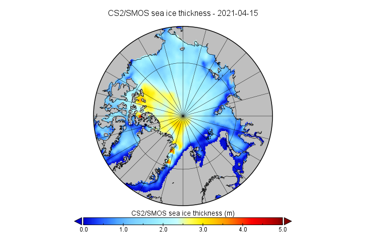
For comparison purposes here’s the CryoSat-2/SMOS equivalent:

ICESat-2 looks to have captured the arm of thicker ice extending across the Beaufort Sea suggested by sea ice age data better than CryoSat-2:

However thickness data is totally absent where leads are absent, in land-fast ice for example. It seems that near real time ICESat-2 processing isn’t available as yet, but we await the release of the data for October with barely bated breath!

Watch this space!

Facts About the Arctic in September 2021

A detailed dissection of the 2021 minimum of various Arctic sea ice extent metrics can be found on a dedicated thread. All other Arctic news in September will be found below.

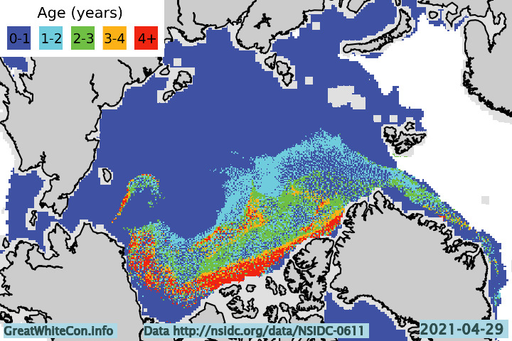
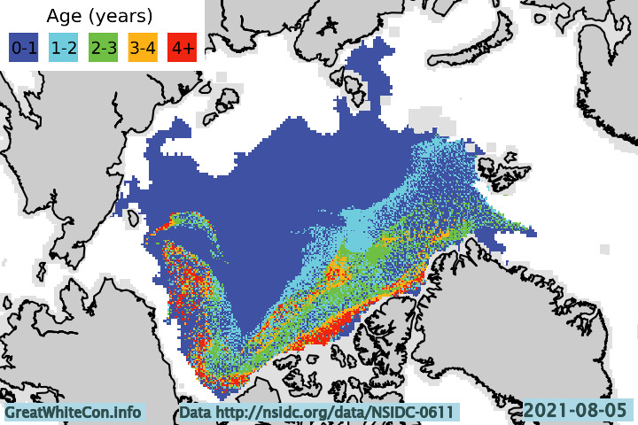
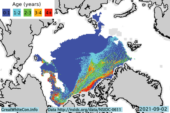
Let’s start with a map of sea ice age at the beginning of August:

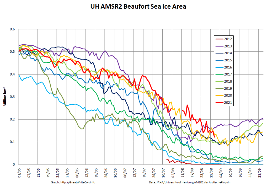
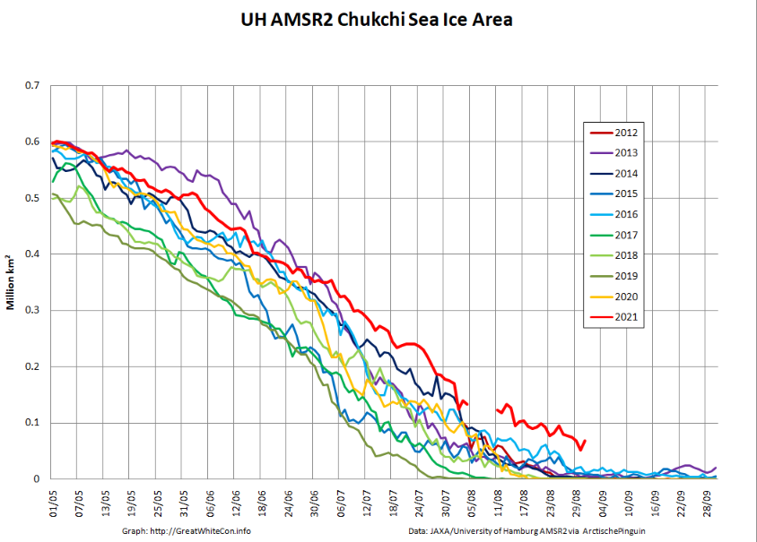
Firstly notice the absence of 3+ year old ice off the coast of north east Greenland. Also visible is a band of 4+ year old ice across the Pacific side of the Arctic Basin, which has slowed melting in the region and explains the following regional sea ice area graphs:


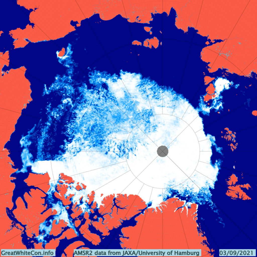
Next here’s the current AMSR2 concentration map:

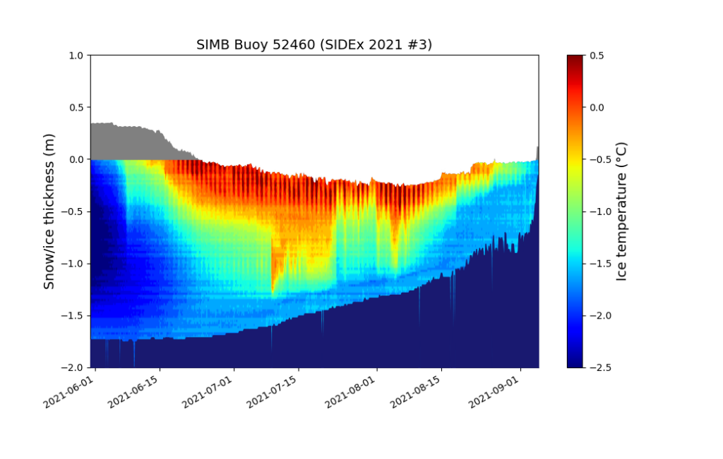
There is currently a large area of open water in the Wandel Sea to the north of Greenland. There is also an arm of old ice across the Beaufort and Chukchi Seas which is still clearly visible, but also visible is the recent reduction in sea ice concentration in the region. By way of explanation, here’s another look at the thickness of an ice floe currently situated to the north of the Chukchi at 74.84 N, 164.29 W, as measured by an ice mass balance buoy:

As the 2021 melting season draws towards its conclusion the floe is experiencing rapid bottom melt. How much longer will this floe and others like it last? Will it survive to become an “old ice” dot on next year’s ice age maps?

[Edit – September 6th]

As Wipneus puts it on the Arctic Sea Ice Forum, “PIOMAS has updated the gridded thickness data up to the 31st of August”. Here’s the latest modelled thickness map, which shows the thickest remaining ice located north of the Canadian Arctic Archipelago rather than north of Greenland:

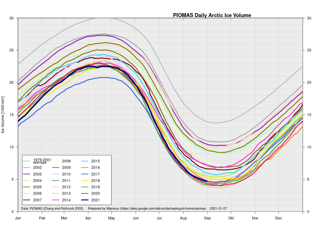
The accompanying volume graph shows 2021 in 7th lowest position, at 4.7 thousand km3:

Here too are the current PIOMAS volume trends for each month of the year:

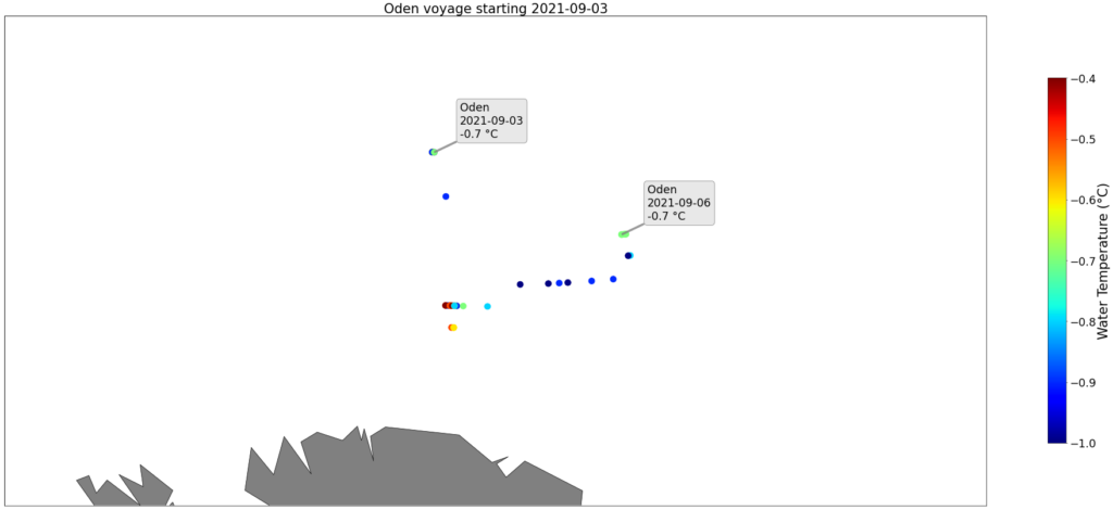
The Swedish icebreaker Oden has recently been exploring the area between northern Greenland and the North Pole as part of the Synoptic Arctic Survey expedition:

Here are the measurements of water temperature it has recorded over the past few days:

Ranging between -0.4 °C and -1.0 °C it doesn’t look as though the 2021 refreeze will be starting in the Wandel Sea just yet.

[Edit – September 10th]

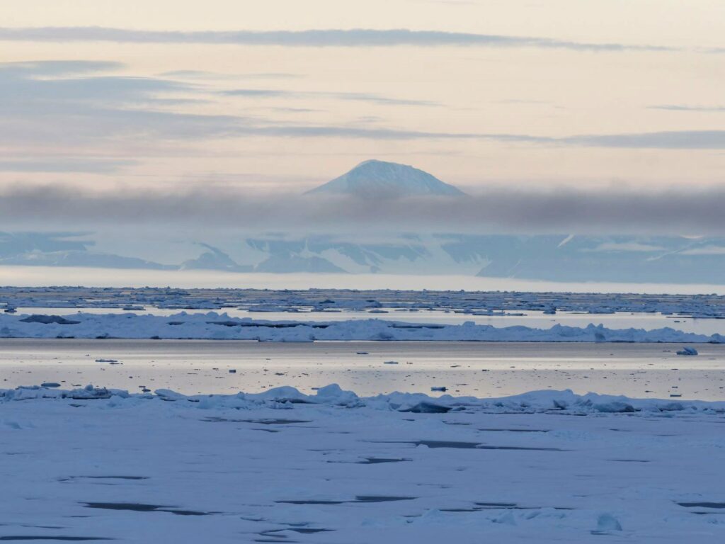
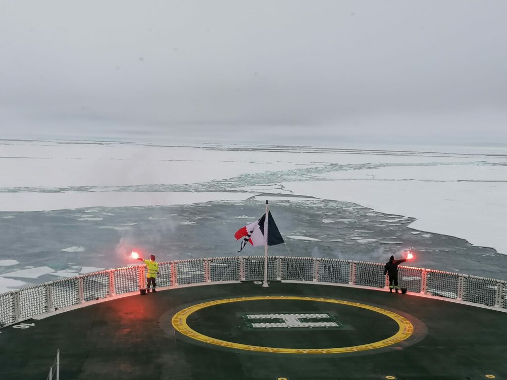
A picture of the sea ice at the North Pole from Ponant’s Le Commandant Charcot on September 6th:

[Edit – September 13th]

Here’s the latest NSIDC sea ice age map:

That shows plenty of old ice still left in the Beaufort Sea. However ice mass balance buoy 52460 now appears to floating free of its ice floe at 75.56 N, 165.99 W:

[Edit – September 14th]

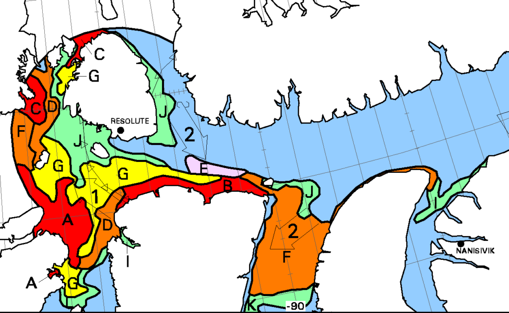
“New ice” has started to appear in previously open water on the Canadian Ice Service charts. See area E south east of Resolute:

[Edit – September 21st]

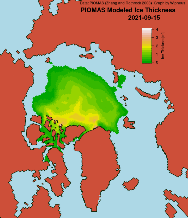
In answer to Frozen Earth’s metaphorical prayer, Wipneus has just released the mid September PIOMAS gridded thickness numbers on the Arctic Sea Ice Forum. First of all the thickness map:

followed by the volume graph:

and the monthly volume trends:

Volume calculated from the thickness data currently show that 2021’s minimum was reached on September 7th at 4.64 thousand km3, which is the 8th lowest value in the Polar Science Center’s record.

[Edit – September 23rd]

NASA have just announced a new paper about clouds in the Arctic. Highly relevant given their recent overview of the 2021 melting season!

Clouds are one of the biggest wildcards in predictions of how much and how fast the Arctic will continue to warm in the future. Depending on the time of the year and the changing environment in which they form and exist, clouds can both act to warm and cool the surface below them.

For decades, scientists have assumed that losses in Arctic sea ice cover allow for the formation of more clouds near the ocean’s surface. Now, new NASA research shows that by releasing heat and moisture through a large hole in sea ice known as a polynya, the exposed ocean fuels the formation of more clouds that trap heat in the atmosphere and hinder the refreezing of new sea ice.

The findings come from a study over a section of northern Baffin Bay between Greenland and Canada known as the North Water Polynya. The research is among the first to probe the interactions between the polynya and clouds with active sensors on satellites, which allowed scientists to analyze clouds vertically at lower and higher levels in the atmosphere.

The approach allowed scientists to more accurately spot how cloud formation changed near the ocean’s surface over the polynya and the surrounding sea ice.

Watch this space!

An Unusual Sea Ice Situation North of Greenland

Further to our recent coverage of the voyage of the good ship Polarstern past Kap Morris Jesup comes this video courtesy of Suman Singha:

An animation created with 2745 high resolution Sentinel-1 SAR images.

Sentinel-1 data courtesy Copernicus

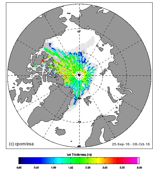
Plus the early autumn estimates of Arctic sea ice thickness from CryoSat-2 via the Centre for Polar Observation and Monitoring:

CS2_thk_14-20181010

Please note the abnormally thin sea ice to the north of Greenland.

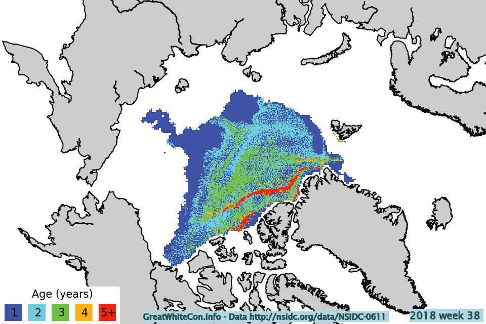
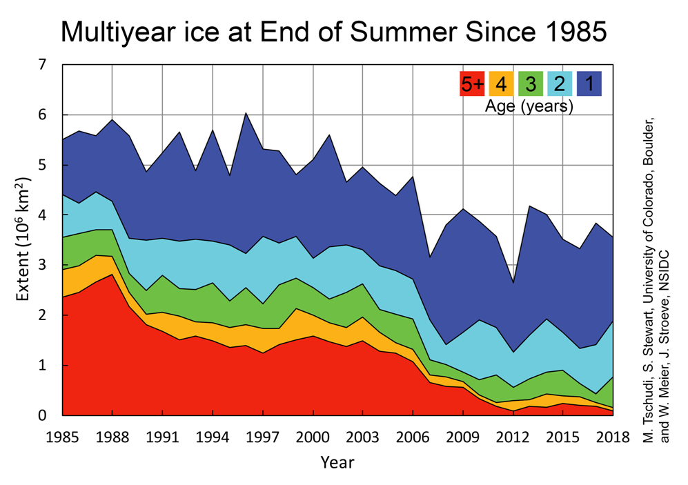
Finally, for the moment at least, here’s the latest Arctic sea ice age information extracted from the October 2018 edition of the NSIDC’s Arctic Sea Ice News:

iceage_browse_week_n_2018_38_QL

TschudiAge2018-1000

The “oldest, thickest sea ice in the Arctic” seems to be vanishing before our very eyes.

Facts About the Arctic in June 2017

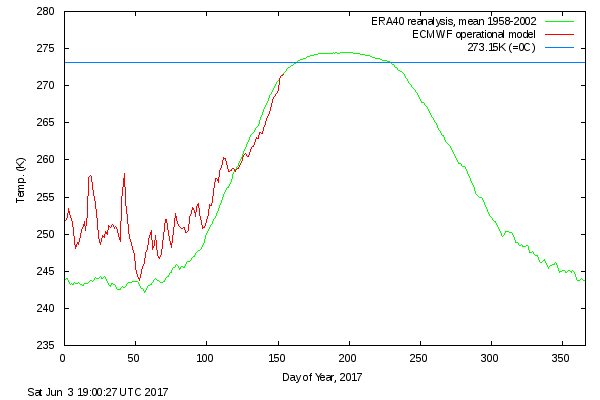
After a comparatively cool May, surface air temperatures in the high Arctic are back up to “normal”:

DMI-meanT_20170603

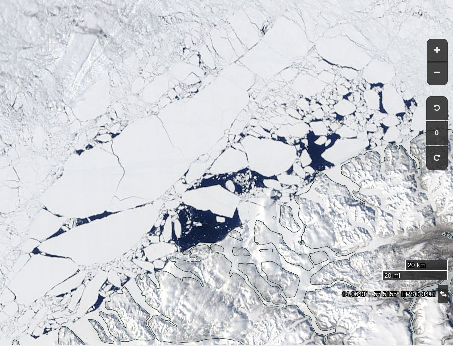
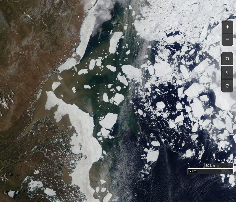
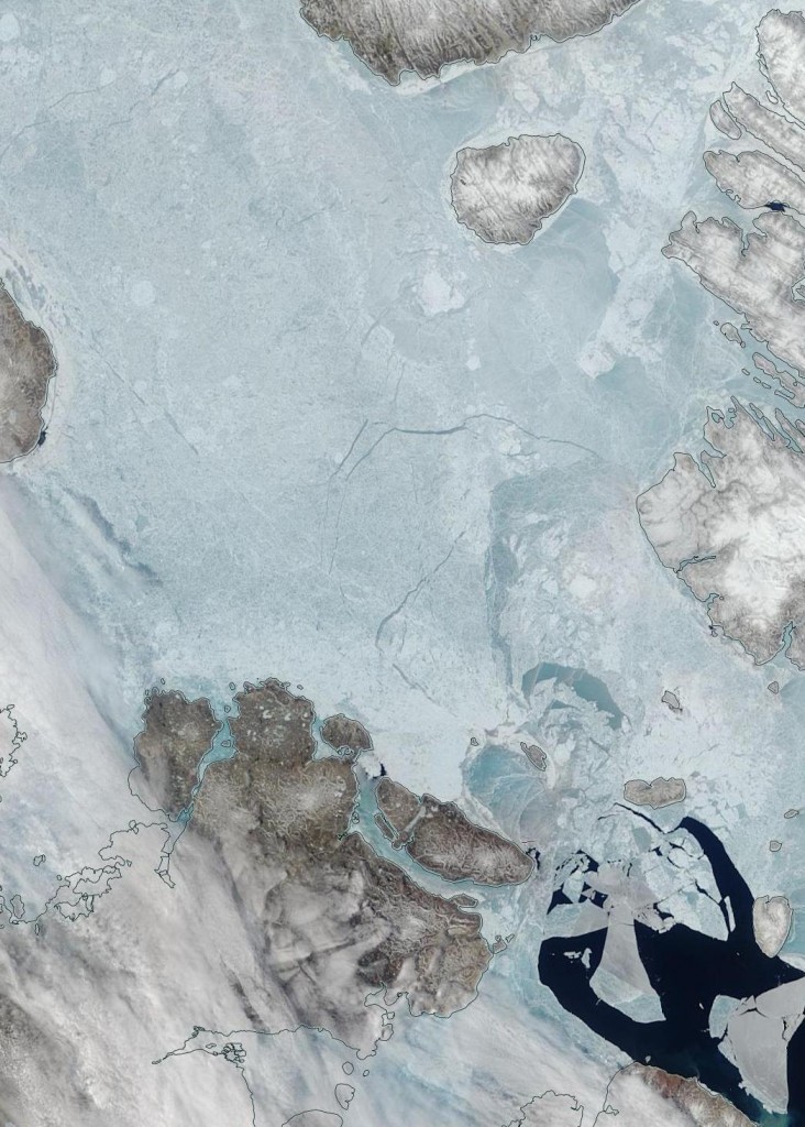
The condition of the sea ice north of 80 degrees is far from normal however. Here’s what’s been happening to the (normally) land fast ice north west of Greenland:

NASA Worldview “true-color” image of the sea ice north west of Greenland breaking up on June 2nd 2017

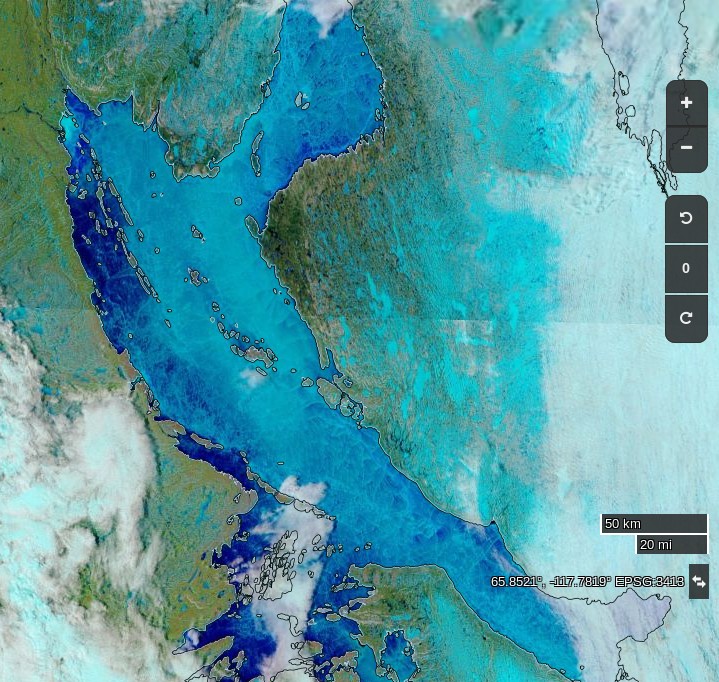
Further south surface melt has set in across the southern route through the Northwest Passage:

NASA Worldview “false-color” image of the Coronation Gulf on June 1st 2017, derived from the MODIS sensor on the Terra satellite

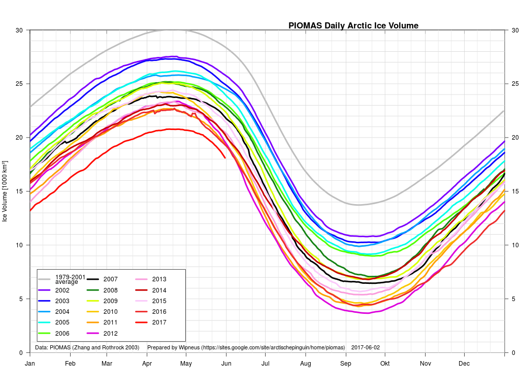
Whilst the gap with previous years has narrowed during May, PIOMAS Arctic sea ice volume is still well below all previous years in their records:

piomas-graph-201705

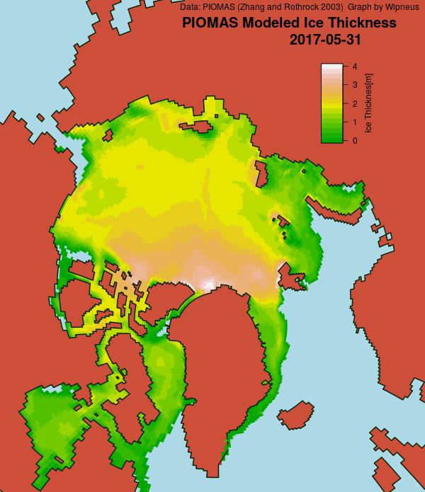
The PIOMAS gridded thickness graph suggests that a large area of thick ice is currently sailing through the Fram Strait to ultimate oblivion:

piomas_gridded_thickness_20170531

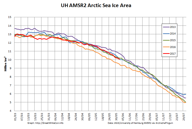
Here’s the latest AMSR2 Arctic sea ice area graph:

UH-Arctic-Area-2017-06-02

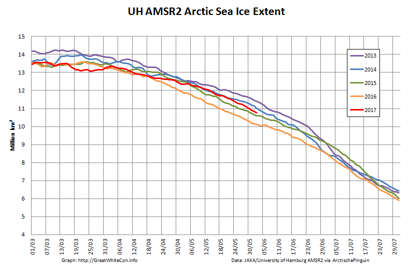
and just in case melt ponds are now affecting those numbers here is extent as well:

UH-Arctic-Extent-2017-06-02

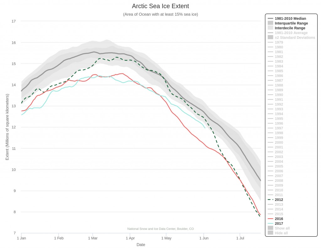
The rate of decrease is inexorably increasing! 2012 extent is currently still well above that of 2017, but those positions may well be reversed by the end of June? Here’s NSIDC’s view on the matter:

Charctic-20170602


[Edit – June 8th]

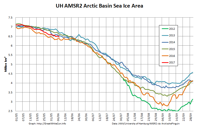
As requested by Tommy, here’s the current Arctic Basin sea ice area:UH-Basin-Area-2017-06-07

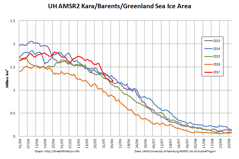
This includes the Beaufort, Chukchi, East Siberian and Laptev Seas along with the Central Arctic. It excludes the Atlantic periphery, which currently looks like this:UH-Atlantic-Area-2017-06-07


[Edit – June 10th]

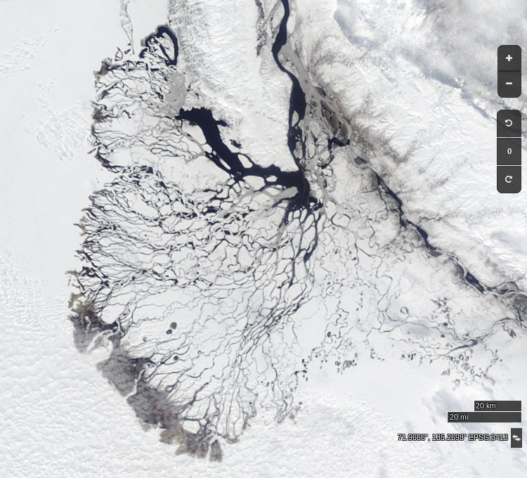
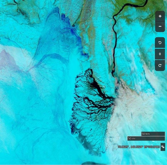
At long last a clear(ish) image of water from the Lena Delta spreading out across the fast ice in the Laptev Sea:

NASA Worldview “true-color” image of the Lena Delta on June 10th 2017, derived from the MODIS sensor on the Terra satellite

Compare and contrast with June 1st last year:

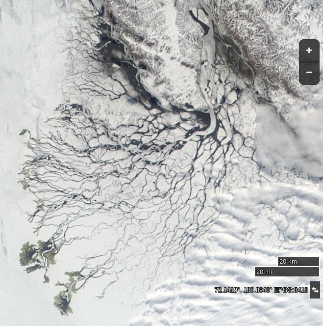
and June 10th 2012:

NASA Worldview “true-color” image of the Lena Delta on June 10th 2012, derived from the MODIS sensor on the Terra satellite


[Edit – June 11th]

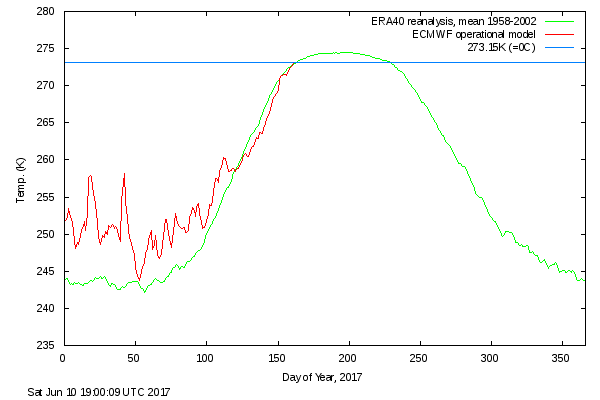
DMI’s daily mean temperature for the Arctic area north of the 80th northern parallel has reached zero degrees Celsius almost exactly on the climatological schedule:

DMI-meanT_20170610

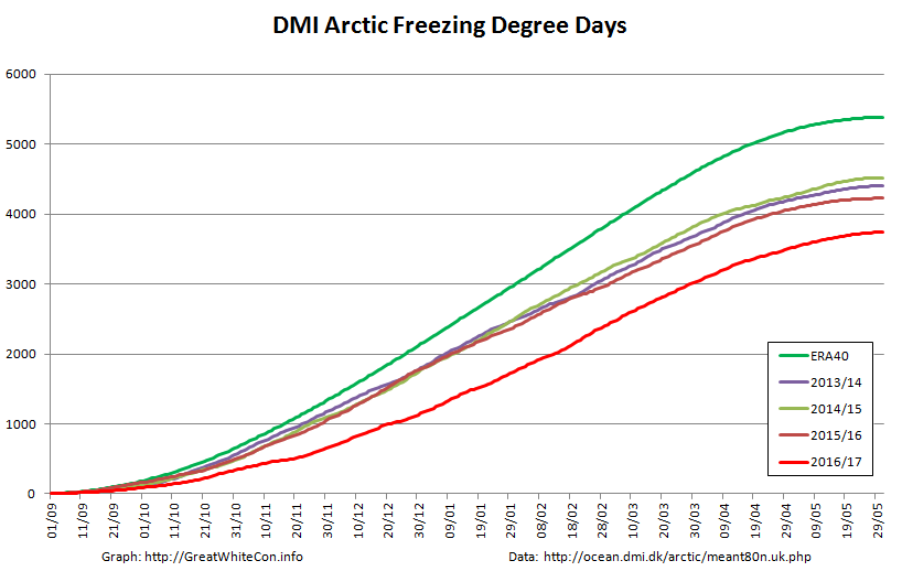
We calculate our freezing degree days on the basis of the freezing point of Arctic sea water at -1.8 degrees Celsius. On that basis this winter’s grand total of 3740 was reached on June 1st:

DMI-FDD-20170531

Despite the “coolish” recent weather total FDDs are way below the climatology and other recent years. Consequently there’s a lot less sea ice in the Arctic left to melt at the start of this Central Arctic melting season than in any previous year in the satellite record. However whilst there are some melt ponds visible in the Arctic Basin on MODIS, in that respect 2017 is lagging behind both last year and 2012.
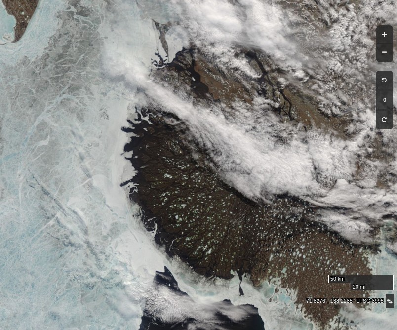
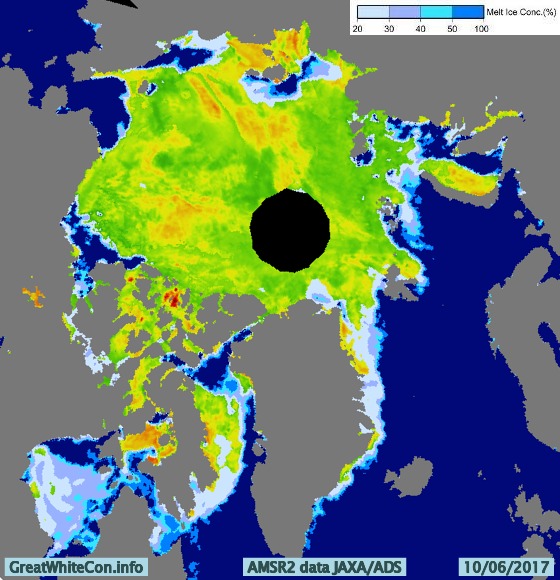
Here’s the latest JAXA surface melt map:AM2SI20170610A_SIT_NP


[Edit – June 13th]

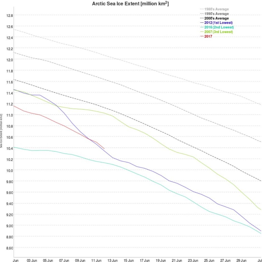
JAXA/IJIS/ADS Arctic sea ice extent for 2017 is now above 2012:

VISHOP_Extent-20170612

Meanwhile there are finally signs of some surface melt on the fast ice in the Laptev Sea:

NASA Worldview “false-color” image of the Laptev Sea on June 13th 2017, derived from the MODIS sensor on the Aqua satellite


[Edit – June 14th]

An animation of the latest Arctic sea ice age data from Mark Tschudi:

Further confirmation that in 2017 the older, thicker ice is gathered together on the Atlantic side of the Arctic Ocean.
 

[Edit – June 15th]

The Mackenzie River melt waters have now breached the fast ice off the delta:

NASA Worldview “true-color” image of the Mackenzie on June 14th 2017, derived from the MODIS sensor on the Terra satellite


[Edit – June 16th]

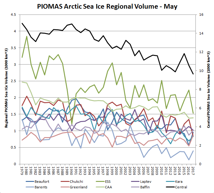
Thanks to the sterling work of Wipneus on the Arctic Sea Ice Forum, here’s a regional breakdown of PIOMAS Arctic Sea Ice volume for the month of May:

PIOMAS-Regions-2017-05

Note the caveat – “No checks, but the data looks plausible”.


[Edit – June 17th]

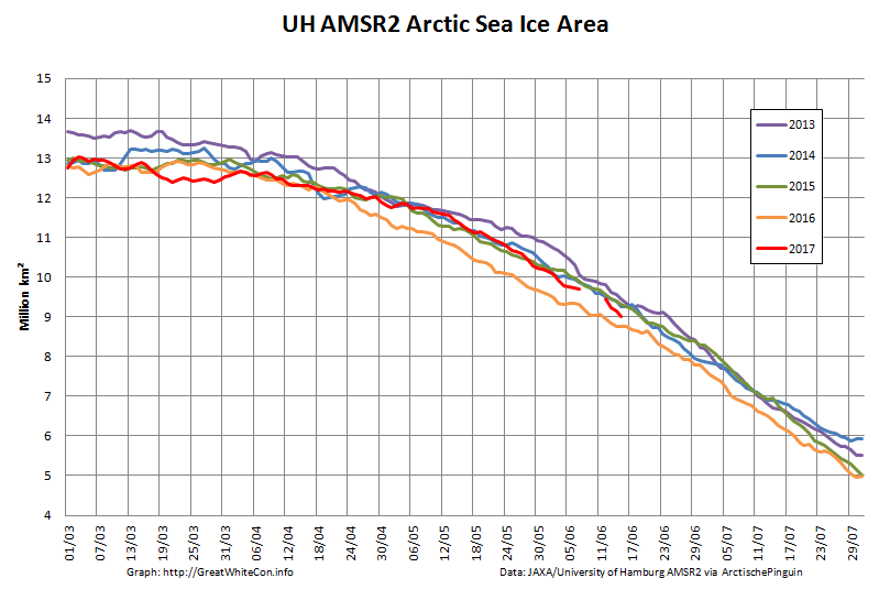
The AMSR2 data feed from the University of Hamburg suffered from a “brief hiatus” a few days ago, but is now back in action:

UH-Arctic-Area-2017-06-15

UH-Arctic-Extent-2017-06-15

Yesterday’s data still hasn’t arrived, but it certainly looks as though 2017 extent will soon drop below 2016.


[Edit – June 18th]

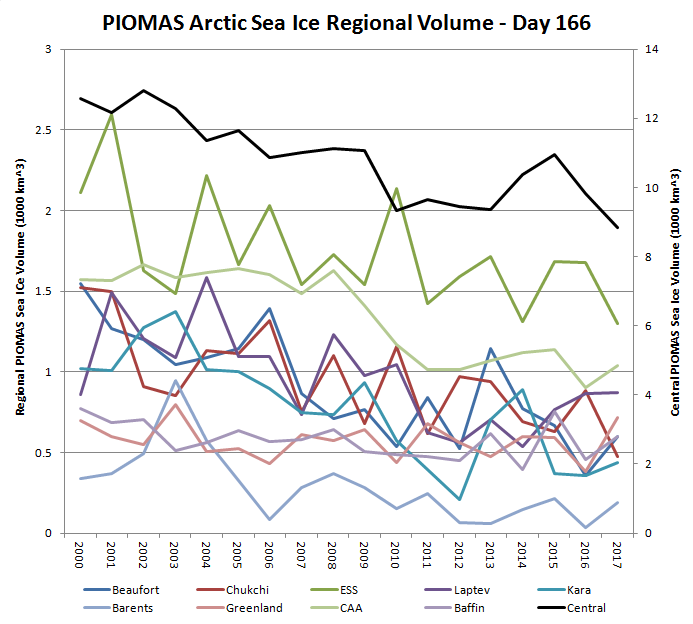
The PIOMAS mid month volume update has arrived. The gap between 2012 and 2017 is closing fast:

piomas-2017-D166

Here’s the regional breakdown:

PIOMAS-Regions-2017-D166


[Edit – June 23rd]

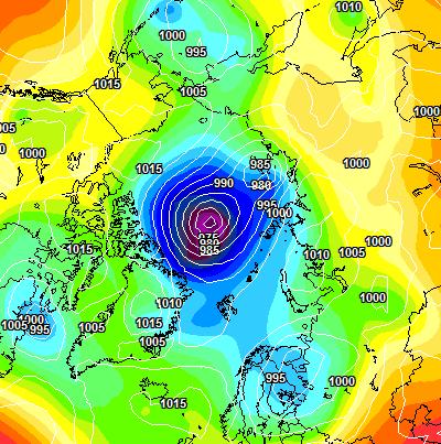
Here is the ECMWF MSLP forecast for 96 hours time:

ECMWF-20170623+96h-400

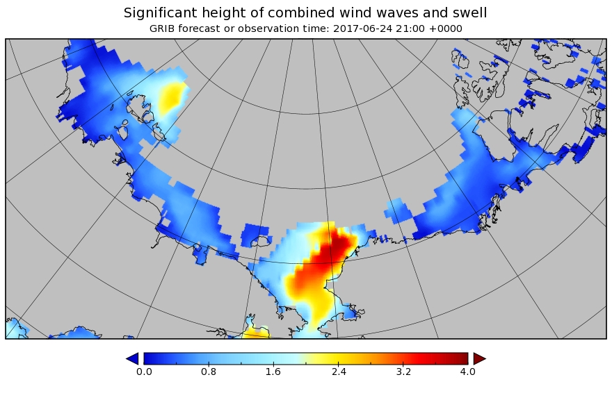
A sub 970 hPa cyclone is starting to enter the realms of realistic possibility, and also forecast are some significant waves in the Chukchi Sea and the expanding 2017 “Laptev Bite”:

Significant_height_of_combined_w in multi_1.glo_30mext.20170623_00016


[Edit – June 27th]

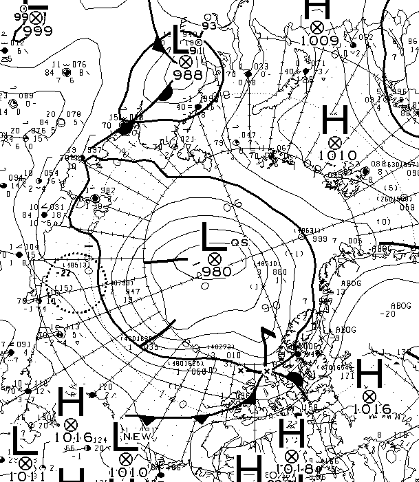
The forecast cyclone was nowhere near as deep as predicted. According to the analysis by Environment Canada it bottomed out at 980 hPa yesterday:

Synopsis-20170626-00Z-Crop


[Edit – June 29th]

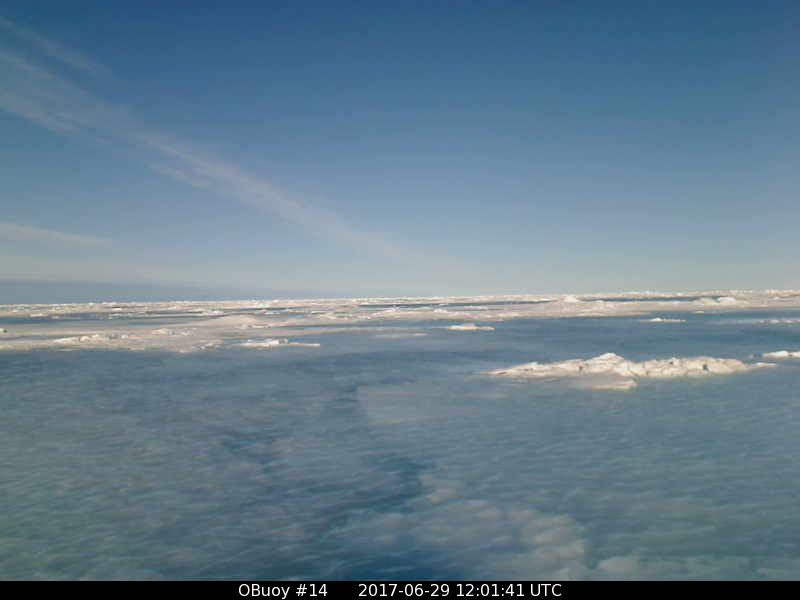
O-Buoy 14 is currently firmly embedded in the fast ice of Viscount Melville Sound, deep in the heart of the Northwest Passage. Here’s the view from the buoy’s camera:

OBuoy14-20170629-1201

and here’s the view from space:

Melville-Terra-2017-06-29

Watch this space!

December 2016 Arctic Report Card

This is the Great White Con version as opposed to the NOAA version published during the Fall AGU conference earlier this week, although there is some overlap.

Hot off the presses, here’s how Arctic sea ice age has progressed over the last year and a bit:

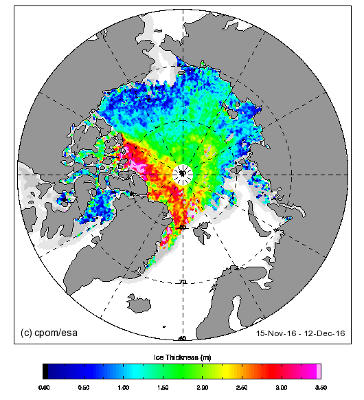
The 4 and 5 year old ice looks to be edging away from the area north of the Canadian Arctic Archipelago towards the Fram Strait. Here’s the current CryoSat-2 Arctic sea ice thickness map:

cryosat_thk_20161212

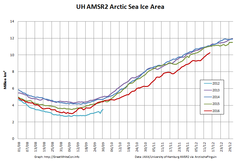
Almost no ice over 2 meters thick to be found in the Beaufort sector or anywhere on the Siberian side of the Arctic. Here’s the current AMSR2 Arctic sea ice area graph:

uh-arctic-area-2016-12-15

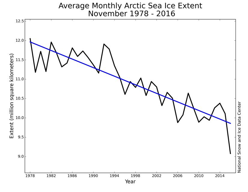
Lowest for the date in the satellite record. Here’s the NSIDC’s long term trend in November sea ice extent:

monthly_ice_11_nh

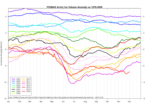
Act 1 of a 3 act play according to Don Perovich at AGU. Here’s the current PIOMAS Arctic sea ice volume anomaly graph:

piomas-anomaly-201611

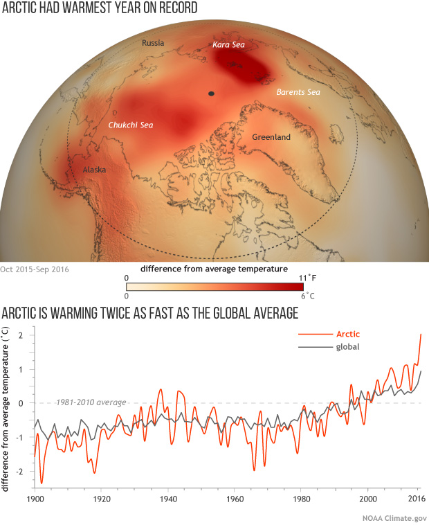
Lowest for the date in the satellite record. Here’s NOAA’s Arctic and global surface temperature graph:

arctictemp_map_graph_2015-16_620

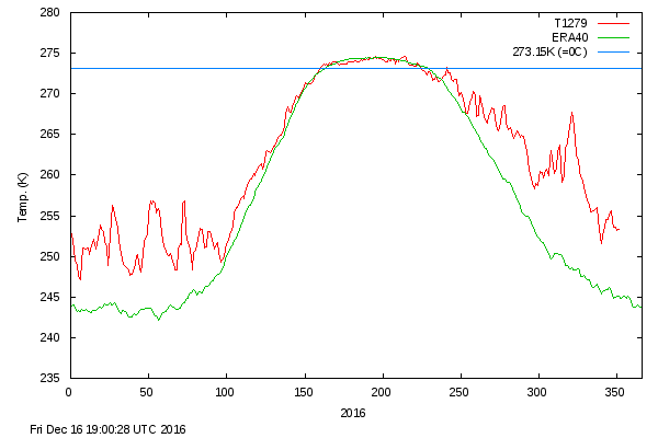
Warmest in a record going back to 1900. Here’s the current DMI >80N surface temperature graph:

dmi_meant_20161216

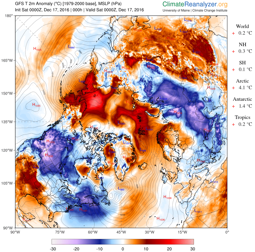
and here’s the current Arctic surface temperature anomaly map:

cci-t2-anomaly-20161217

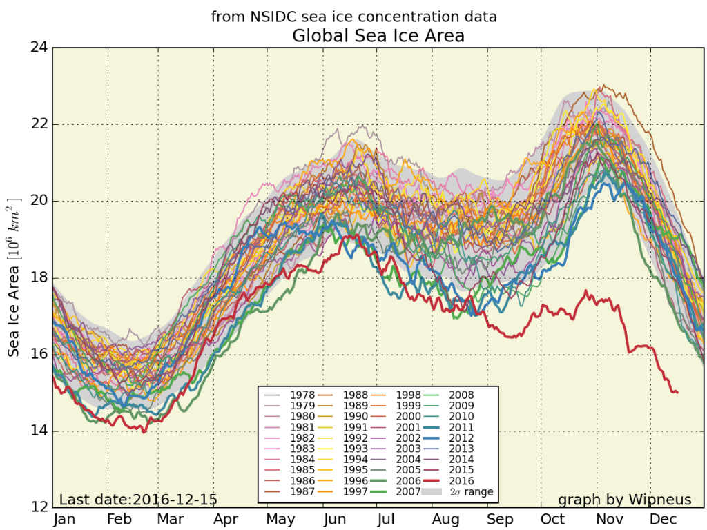
Finally, for the moment at least, here’s global sea ice area just for good measure:

nsidc_global_area_20161216


Need I say more? How about this:


Ice has no agenda. It just melts.
Out of the labs and into the streets?

“Steve Goddard” Busted

Our headline today is inspired by Tony Heller, probably still better known by his nom de guerre “Steven Goddard”, who excitedly tells the world:

NSIDC Busted!

Reader Chris71 has discovered the smoking gun on the NSIDC web site. Read on.

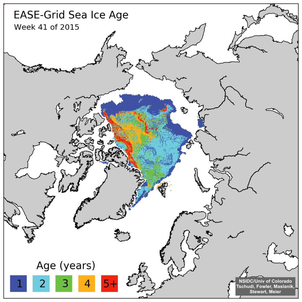
A few weeks ago, NSIDC put out this press release, claiming that 5+ year old ice is at its smallest level on record.

The press release included the map below. This is a new style map which they just started in week 39 2015. The map below is for week 41 2015. All of their previous 1984-2015 maps have been deleted from their archive.

iceage_browse_week_n_2015_41-1024x1024

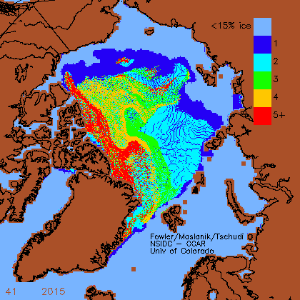
The good news is that Chris found one of their old style maps which had not been scrubbed from their website. NSIDC has deleted the original graphs, but seem to have forgotten to get rid of the copy.

iceage-2015-41

For some strange reason “Steve” neglects to mention this text that accompanied the “old style map” he so proudly displays:

Here are some graphs from the Arctic – automatically saved here, and some of them archived Enjoy! Fred aka DungeonMaster on http://forum.arctic-sea-ice.net/.

Have I got news for Chris and “Steve”? Indeed I have! If one were to bother to go to the relevant section of the NSIDC web site instead of inventing bizzare fairy tales one would be able to read this:

EASE-Grid Sea Ice Age, Version 3

This data set provides weekly estimates of sea ice age for the Arctic Ocean from remotely sensed sea ice motion and sea ice extent.

The input ice motion data used for this data set is now derived from NSIDC-0116 Version 3 data.

Checking out the detailed information provided about the NSIDC-0116 Polar Pathfinder Daily 25 km EASE-Grid Sea Ice Motion Vectors, Version 3 would also reveal:

Version 3 – February 2016.

  • Eliminated unrealistic AVHRR and IABP buoy velocities

  • Extended buoy ice motion estimates to the present

  • Improved browse images

  • Reprocessed SSMI fields using GDAL map transformations on the DMSP SSM/I-SSMIS

  • Daily Polar Gridded Brightness Temperatures Data Set, NSIDC-0001.

  • Used Ice concentration estimates greater than 15 percent from the Sea Ice Concentrations from Nimbus-7 SMMR and DMSP SSM/I-SSMIS Passive Microwave Data Set, NSIDC-0051, to indicate where ice extent is present.

Checking out the detailed information provided about the NSIDC-0611 EASE-Grid Sea Ice Age, Version 3 would further reveal:

The sea ice age data in these files are derived using data from satellite passive microwave instruments, drifting buoys, and a weather model. With these data sources, the formation, movement, and disappearance of sea ice can be observed; and these observations can, in turn, be used to estimate ice age (Maslanik et al. 2007). The ice age data are derived from a number of passive microwave imagers: the Scanning Multichannel Microwave Radiometer (SMMR), the Special Sensor Microwave/Imager (SSM/I), and the Special Sensor Microwave Imager Sounder (SSMIS). Visible and infrared data from the Advanced Very High Resolution Radiometer (AVHRR) were also utilized through 2004. In addition, International Arctic Buoy Program (IABP) drifting-buoy vectors and the National Centers for Environmental Prediction (NCEP)/National Center for Atmospheric Research (NCAR) Reanalysis Project (CDAS) are used to augment the satellite data (Tschudi 2010).

Version 3 – April 2016.

So there you have it “Steve”. Thanks to the sterling (albeit uncredited!) efforts of the all volunteer members of the Arctic Sea Ice Forum and the (presumably still paid?) scientists at the National Snow and Ice Data Center you can now explain the truth, the whole truth, and nothing but the truth of the matter to your own loyal readers.

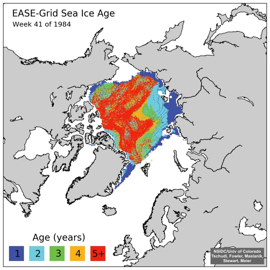
A few weeks ago the NSIDC upgraded their sea ice age product from version 2 to version 3. Here’s what the latest version of 1984 week 41 looks like:

iceage.week.1984.41.n.v3

Can you spot the difference Tony?

[Edit – May 1st 2016]

In partial answer to a question posed below, here’s an animation of Arctic sea ice age from September 2010 to May 2015. Can you see what has happened to the old ice Tony?


Original Arctic sea ice age images from: Tschudi, M., C. Fowler, J. Maslanik, J. S. Stewart, and W. Meier. 2016. EASE-Grid Sea Ice Age, Boulder, Colorado USA: NASA National Snow and Ice Data Center Distributed Active Archive Center. http://dx.doi.org/10.5067/PFSVFZA9Y85G.

[Edit – May 30th 2016]

Here’s a “Storified” summary of my Twitter “debate” with Tony Heller and Patrick Moore: