This is the Great White Con version as opposed to the NOAA version published during the Fall AGU conference earlier this week, although there is some overlap.
Hot off the presses, here’s how Arctic sea ice age has progressed over the last year and a bit:
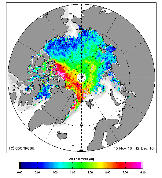
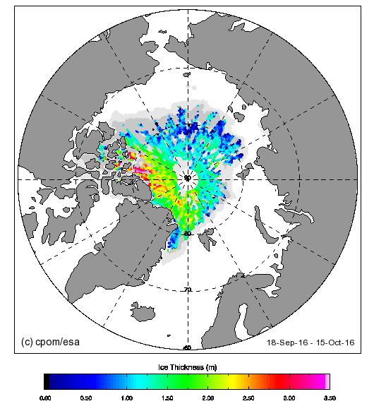
The 4 and 5 year old ice looks to be edging away from the area north of the Canadian Arctic Archipelago towards the Fram Strait. Here’s the current CryoSat-2 Arctic sea ice thickness map:
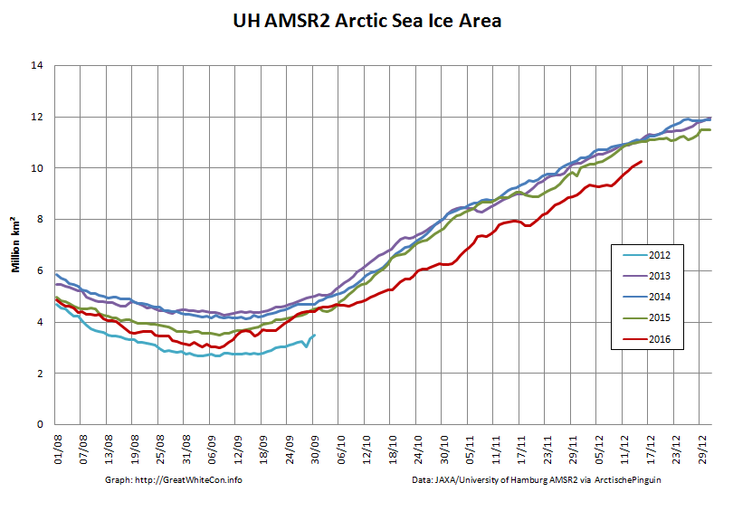
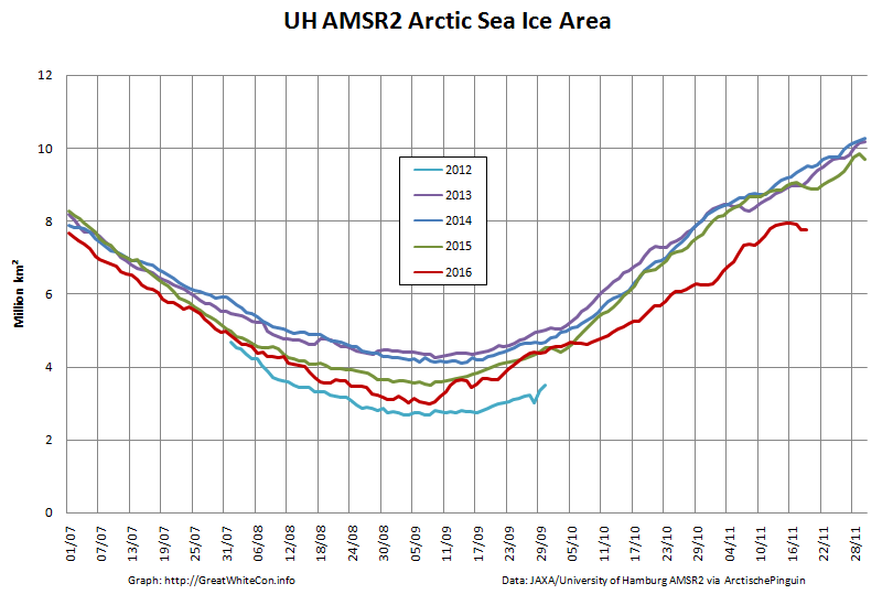
Almost no ice over 2 meters thick to be found in the Beaufort sector or anywhere on the Siberian side of the Arctic. Here’s the current AMSR2 Arctic sea ice area graph:
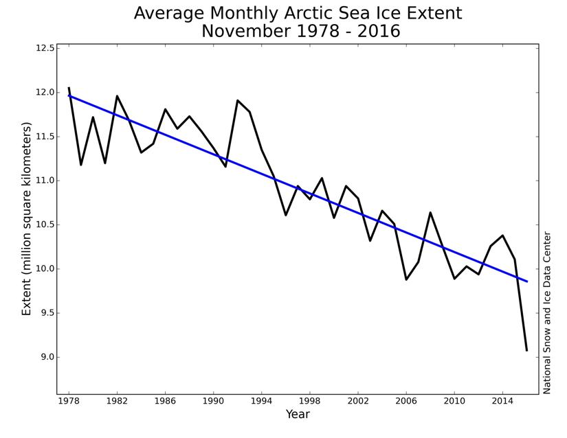
Lowest for the date in the satellite record. Here’s the NSIDC’s long term trend in November sea ice extent:
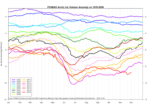
Act 1 of a 3 act play according to Don Perovich at AGU. Here’s the current PIOMAS Arctic sea ice volume anomaly graph:
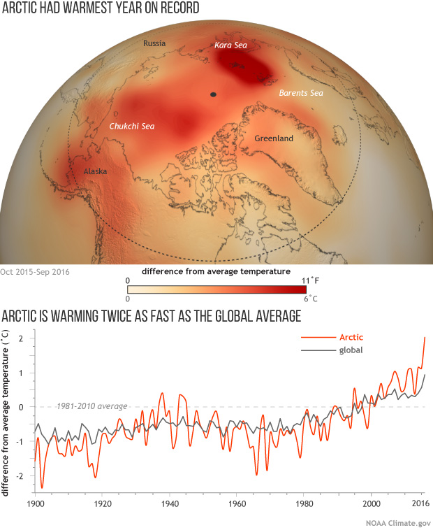
Lowest for the date in the satellite record. Here’s NOAA’s Arctic and global surface temperature graph:
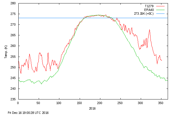
Warmest in a record going back to 1900. Here’s the current DMI >80N surface temperature graph:
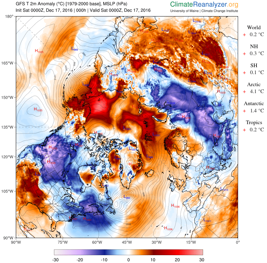
and here’s the current Arctic surface temperature anomaly map:
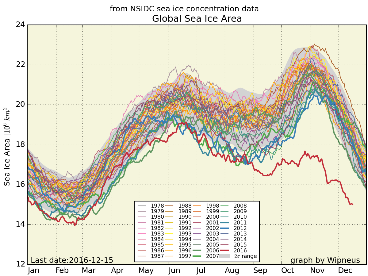
Finally, for the moment at least, here’s global sea ice area just for good measure:
Need I say more? How about this:
Ice has no agenda. It just melts.
Out of the labs and into the streets?
I just watched the live stream of the fall 2016 AGU press conference about the findings of the “First results from the Norwegian Young Sea ICE Expedition”.
Here’s the associated video of the expedition:
Here are the bullet points:
Initial results suggest that the thinner and younger ice is altogether different from older multiyear ice. It moves faster, breaks up easier, melts faster, and is more vulnerable to storms. This has important consequences for the Arctic as a whole, as our current knowledge is largely based on information from the “old Arctic.”
The Atmosphere
• For the first time, N-ICE2015 researchers directly observed large winter storms over sea ice and saw that they have significant effects on the young, thinner ice. The high winds create a lot of stress on the sea ice by pushing it around and breaking it up.
• One winter storm raised the air temperature from -40 F to +32 F in less than 48 hours, while the moisture in the air increased 10 times. All of these factors significantly warm the surface of the snow, even in mid-winter, and slow the growth of ice.
The Sea Ice and Snow Cover
• Researchers on the drifting ice camps found more snow on top of the ice than expected. This insulated the ice from the atmosphere, slowing its growth in winter and surface melt in summer.
• The sea ice was sometimes flooded by seawater as the large snow load pushed the thinner ice below sea level.
• The thinner sea ice was more dynamic than researchers have seen before. This could mean more ridging but also more cracks and leads between ice floes.
The Ocean
• Winter storms caused the sea ice to drift so fast that it increased mixing of the water beneath the ice. Deeper, warmer water was mixed up closer to the sea ice, causing it to melt from below despite winter air temperatures that were below freezing.
• Researchers saw summer storms stir up deep warm waters and melt as much as 25 cm of ice in a single day.
The Ecosystem
• For the first time, N-ICE2015 researchers observed an algae bloom under snow-covered pack ice. Thinner and more dynamic Arctic sea ice allows more light transmission to the ocean, especially through cracks and leads. This triggers earlier phytoplankton blooms under the snow-covered ice.
• The phytoplankton species that dominated the under-ice bloom does not sink to the deep ocean. Such shifts in phytoplankton species composition, associated with early under-ice phytoplankton blooms, could thus have important implications for the strength of the biological carbon pump in the Arctic.
There was also mention of the “waves in ice” event that the R/V Lance experienced back in June 2015:
P.S. A recording of the N-ICE2015 press conference is now available:
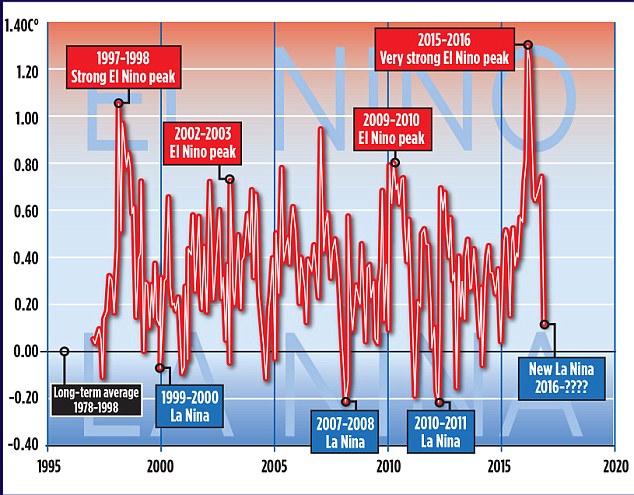
No doubt because of the recent controversy concerning the effects of the 2015/16 El Niño the first graphic that caught my eye was this one:
In the question and answer session the obvious question was asked. The answer was that while attribution is difficult the 2015/16 El Niño did have some effect on Arctic sea ice. However currently we’ve only seen “the first act of a 3 act play”. Act 2 will be the maximum extent in March.
In answer to another question, a focus of research over the next 10 years should be the interactions between mid latitudes and the Arctic.
P.S. A recording of the Arctic Report Card press conference is now available:
A variety of cryospheric posters are available via:
“Post-truth” is the the Oxford Dictionaries word of the year for 2016. The definition reads as follows:
post-truth – an adjective defined as ‘relating to or denoting circumstances in which objective facts are less influential in shaping public opinion than appeals to emotion and personal belief’.
and according to Oxford Dictionaries:
The concept of post-truth has been in existence for the past decade, but Oxford Dictionaries has seen a spike in frequency this year in the context of the EU referendum in the United Kingdom and the presidential election in the United States. It has also become associated with a particular noun, in the phrase post-truth politics.
Post-truth has gone from being a peripheral term to being a mainstay in political commentary, now often being used by major publications without the need for clarification or definition in their headlines.
Our old friend David Rose has been remarkably quiet on the topic of Arctic sea ice recently. Presumably the objective facts from the Arctic are impossible to spin to his satisfaction even for a man of David’s talents? However that didn’t stop him from penning an article for The Mail on Sunday at the end of November on the topic of the recent “record highs in global temperatures“:
Global average temperatures over land have plummeted by more than 1C since the middle of this year – their biggest and steepest fall on record.
The news comes amid mounting evidence that the recent run of world record high temperatures is about to end. The fall, revealed by Nasa satellite measurements of the lower atmosphere, has been caused by the end of El Niño – the warming of surface waters in a vast area of the Pacific west of Central America.
The Mail article helpfully included this one year old video from the World Meteorological Organization, explaining the basics of the El Niño phenomenon:
According to the commentary:
This phenomenon affects weather conditions across the equatorial Pacific, with potential knock on effects in other parts of the world.
We’ll get on to the “potential knock on effects” in the Arctic eventually, but let’s start with a snippet of Mr. Rose’s “post-truth politics”:
Some scientists, including Dr Gavin Schmidt, head of Nasa’s climate division, have claimed that the recent highs were mainly the result of long-term global warming.
Last year, Dr Schmidt said 2015 would have been a record hot year even without El Nino. ‘The reason why this is such a warm record year is because of the long-term underlying trend, the cumulative effect of the long-term warming trend of our Earth,’ he said. This was ‘mainly caused’ by the emission of greenhouse gases by humans.
Other experts have also disputed Dr Schmidt’s claims. Professor Judith Curry, of the Georgia Institute of Technology, and president of the Climate Forecast Applications Network, said yesterday: ‘I disagree with Gavin. The record warm years of 2015 and 2016 were primarily caused by the super El Nino.’ The slowdown in warming was, she added, real, and all the evidence suggested that since 1998, the rate of global warming has been much slower than predicted by computer models – about 1C per century.
David Whitehouse, a scientist who works with Lord Lawson’s sceptic Global Warming Policy Foundation, said the massive fall in temperatures following the end of El Nino meant the warming hiatus or slowdown may be coming back. ‘According to the satellites, the late 2016 temperatures are returning to the levels they were at after the 1998 El Nino. The data clearly shows El Nino for what it was – a short-term weather event,’ he said.
In case you’re wondering where the politics is in all of this, you need look no further than here:
The last three years may eventually come to be seen as the final death rattle of the global warming scare. Thanks [sic] what’s now recognised as an unusually strong El Nino, global temperatures were driven to sufficiently high levels to revive the alarmist narrative – after an unhelpful pause period of nearly 20 years – that the world had got hotter than ever before.
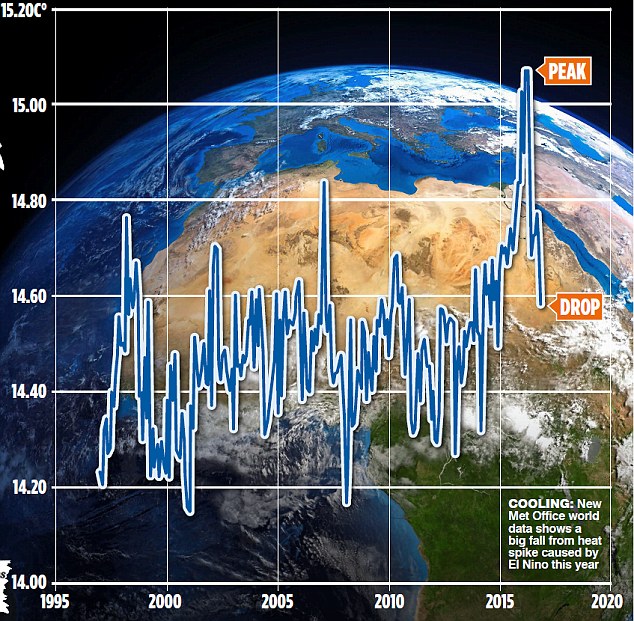
In case you’re also wondering about the objective facts of the matter David Rose quotes with approval “the authoritative Met Office ‘Hadcrut4’ surface record” in his latest article in the Mail on Sunday this very morning:
New official data issued by the Met Office confirms that world average temperatures have plummeted since the middle of the year at a faster and steeper rate than at any time in the recent past.
The huge fall follows a report by this newspaper that temperatures had cooled after a record spike. Our story showed that these record high temperatures were triggered by naturally occurring but freak conditions caused by El Nino – and not, as had been previously suggested, by the cumulative effects of man-made global warming.
The Mail on Sunday’s report was picked up around the world and widely attacked by green propagandists as being ‘cherry-picked’ and based on ‘misinformation’. The report was, in fact, based on Nasa satellite measurements of temperatures in the lower atmosphere over land – which tend to show worldwide changes first, because the sea retains heat for longer.
There were claims – now exploded by the Met Office data shown here – that our report was ‘misleading’ and ‘cherry-picked’.
Yet bizarrely, the fiercest criticism was reserved for claims we never made – that there isn’t a long-term warming trend, mainly caused by human emissions.
This just wasn’t in our report – which presumably, critics hadn’t even read.
We’ve explained all this to David before, yet bizzarely we obviously need to do so again. Here’s the Mail’s version of the latest HADCRUT 4 data from the Met Office:
Can you spot any “cumulative effects of man-made global warming”?
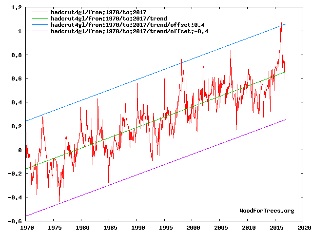
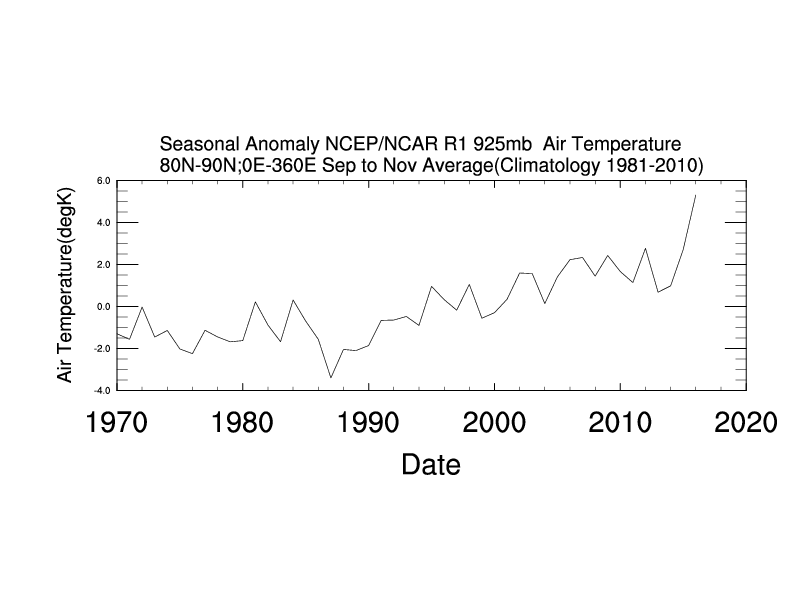
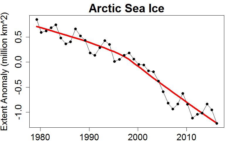
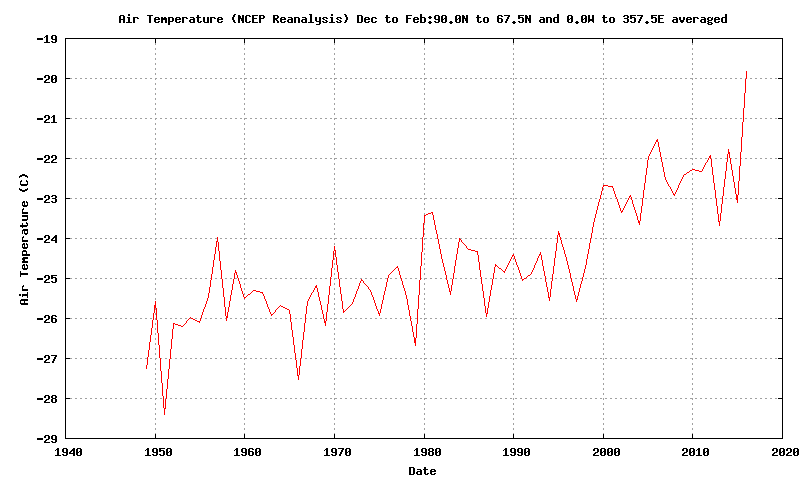
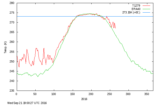
Messrs Smith, Rose, Delingpole, Whitehouse et al. may well be unaware of the fact that the satellite temperature data they’re so fond of cherry picking doesn’t include data from the lower troposphere between 80 degrees North and the North Pole. Just in case they fancy spinning the latest objective facts from the Arctic in the near future, here’s the long term autumnal temperature trend:
Regular readers may recall that as 2016 began we pondered how “Storm Frank” might have affected the Arctic. Now NASA have published some research into that very topic, entitled ” The Impact of the Extreme Winter 2015/16 Arctic Cyclone on the Barents–Kara Seas”. The paper itself is paywalled, but according to an associated article on the NASA web site:
A large cyclone that crossed the Arctic in December 2015 brought so much heat and humidity to this otherwise frigid and dry environment that it thinned and shrunk the sea ice cover during a time of the year when the ice should have been growing thicker and stronger.
The cyclone formed on Dec. 28, 2015, in the middle of the North Atlantic, and traveled to the United Kingdom and Iceland before entering the Arctic on Dec. 30, lingering in the area for several days. During the height of the storm, the mean air temperatures in the Kara and Barents seas region, north of Russia and Norway, were 18 degrees Fahrenheit (10 degrees Celsius) warmer than what the average had been for this time of the year since 2003.
The extremely warm and humid air mass associated with the cyclone caused an amount of energy equivalent to the power used in one year by half a million American homes to be transferred from the atmosphere to the surface of the sea ice in the Kara-Barents region. As a result, the area’s sea ice thinned by almost 4 inches (10 centimeters) on average.
At the same time, the storm winds pushed the edges of the sea ice north, compacting the ice pack.
Here’s a video with commentary by Linette Boisvert, lead author of the paper:
From the commentary:
As a result of this cyclone, the concentration of the sea ice in the Barents and Kara Seas decreased by ten percent, and the sea ice edge moved northward. The loss in sea ice area during this time was equivalent to the size of Florida. Sea ice extent stayed low throughout the month of January with large parts of the Barents and Kara Seas remaining unseasonably ice-free, which probably helped contribute to a record low Arctic sea ice maximum.
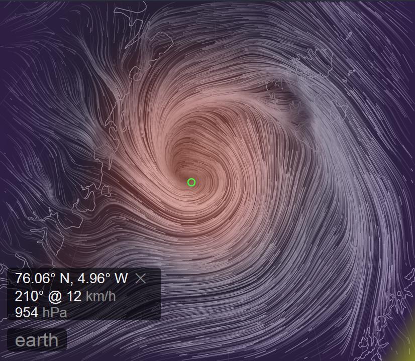
Somewhat earlier than last year another strong cyclone has been having a similar effect on the Arctic over the last week. A cyclone entered the Central Arctic via the Fram Strait, reaching a minimum central pressure of 954 hPa on November 14th:
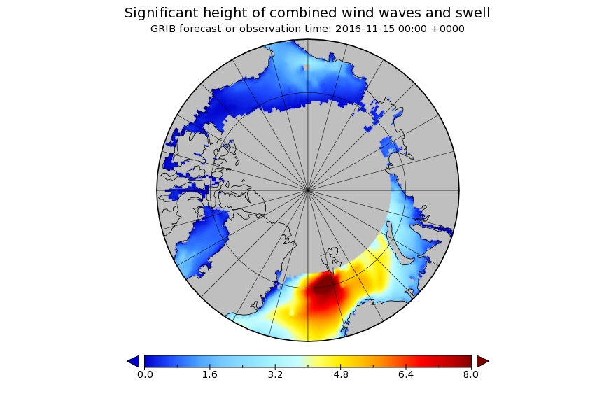
Here is the Wavewatch III wave height forecast for November 15th 2016:
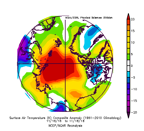
and here is NOAA’s temperature anomaly reanalysis for November 16th 2016:
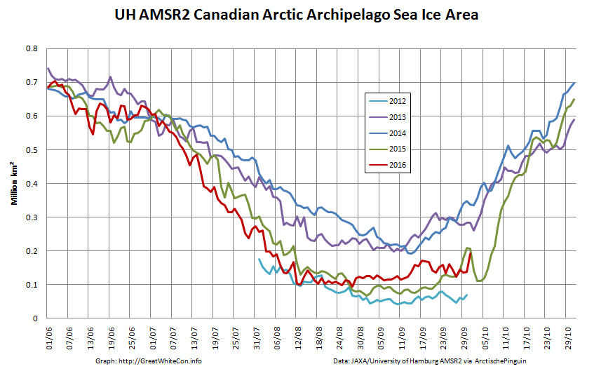
As a consequence of the strong winds, huge waves and 20 degrees Celsius temperature anomaly across much of the Arctic, sea ice area has been falling during a period when it is usually increasing rapidly:
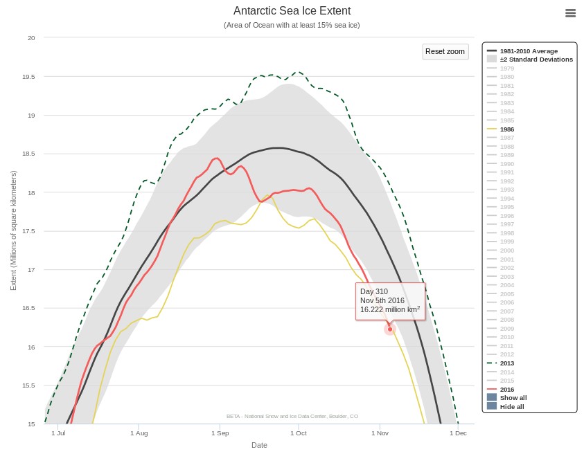
NSIDC 5 day averaged Antarctic sea ice extent is now at a record low level for the date, since satellite measurements began in 1979:
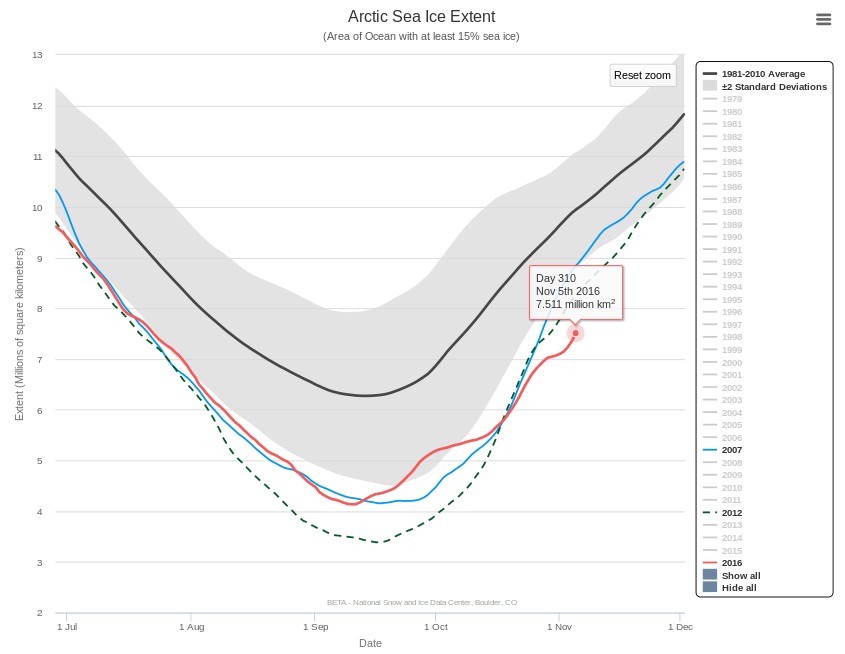
NSIDC 5 day averaged Arctic sea ice extent has been at a record low level for the date for quite a while:
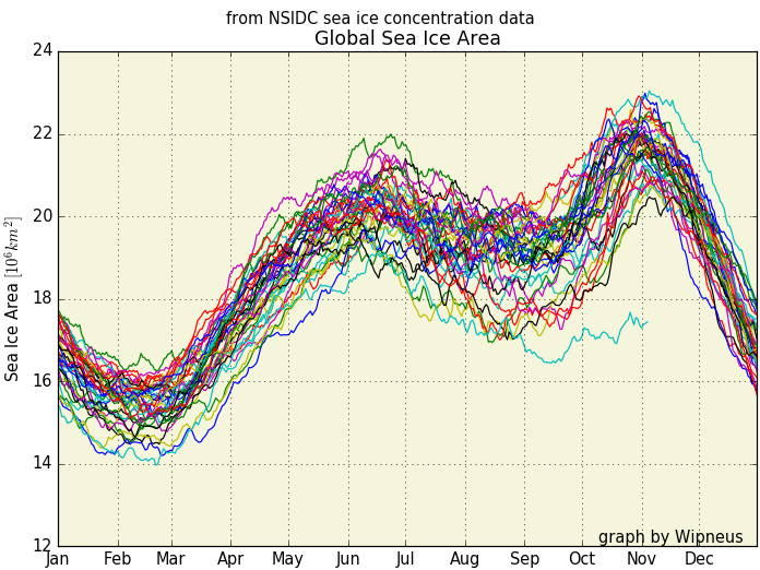
Combining those two facts means that global sea ice extent is also at a record low level for the date by a considerable margin. The gap with all previous years in the satellite record is even more stark if you look at global sea ice area:
CryoSat-2 has burst back into life after its summer break. Here is what it reveals about Arctic sea ice thickness at the moment:
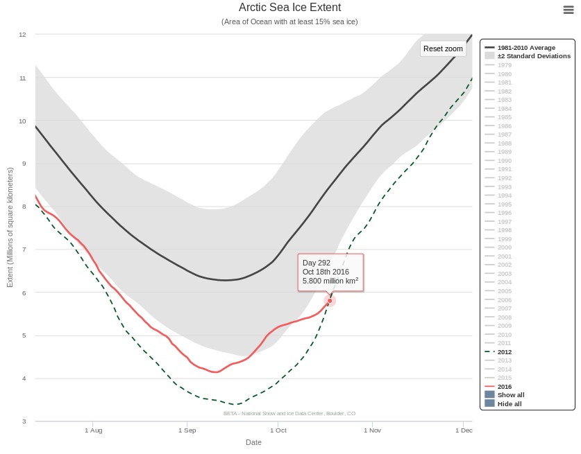
Perhaps not entirely coincidentally, the NSIDC 5 day average Arctic sea ice extent is once again less than on the same day of 2012, the year of the “record melt”:
Our title for today does of course refer to the inconvenient hiatus caused by the Gremlins currently stealing my comments from under the noses of Anthony Watts’ eagle eyed team of moderators before they can approve them as suitable for public view. Yesterday Mr. Watts published an article under the headline:
Since hitting its earliest minimum extent since 1997, Arctic sea ice has been expanding at a phenomenal rate. Already it is greater than at the same date in 2007, 2008, 2010, 2011, 2012 and 2015. Put another way, it is the fourth highest extent in the last ten years. Even more remarkably, ice growth since the start of the month is actually the greatest on record, since daily figures started to be kept in 1987.
As I wrote when looking at last year’s data the declining Arctic ice cover has been one of the most powerful images of climate change and that many who follow the debate don’t look too hard at the data. This results in superficial reporting that does not convey any of the complexities of the situation and as such is poor science communication.
With the data for 2016 now in it is time to look again at the claims of an “ice pause.”
In the spirit of improving science communication I commented as follows on Mr. Watts article, when seven previous comments were visible:
Annual average sea ice was all the rage last year:
You may well be wondering what a graph of annual average Arctic sea ice extent looks like? Take a look:
Discuss.
This morning (UTC) there are 197 comments visible under the WUWT article, but mine is not amongst them. Those Gremlins have a lot to answer for!
You may possibly think my comment was somewhat on the terse side? In part that’s because I’d just had a “debate” of sorts with one or more WUWT moderators who happily admitted to [snip]ping large parts of my side of the “conversation”. I certainly didn’t want to offend them by “taking pot shots” or engaging in “self promotion”. After all they had concluded their remarks by informing me that:
It is settled then …you are mendacious
The SIMPLEST solution is to stop attempting to post comments here. We are not required to carry them.
Needless to say my most recent witty riposte was grabbed by the Gremlins:
Just in case you were wondering what a mendacious moderator might mean:
[men-dey-shuh s]
adjective
1. telling lies, especially habitually; dishonest; lying; untruthful:
a mendacious person.
A reader writes to ask us to explain the answer to the above question in more detail. Are you sitting comfortably once again? Then let us begin.
There has been a lot of unusual “weather” in the Arctic over the last twelve months. First of all there was an anomalously warm winter:
Then came what we dubbed the Great Arctic Anticyclone of 2016 in April. Take a look at what happened to the sea ice north of Alaska and Canada during the Spring and early Summer:
The ice was put through the mincer for the first time. Then during August there were a series of strong cyclones, collectively the Great Arctic Cyclone of 2016. The ice was put through the mincer once again, but in an anti-clockwise direction this time. Watch what happens in the Northwest Passage as summer turns to Autumn:
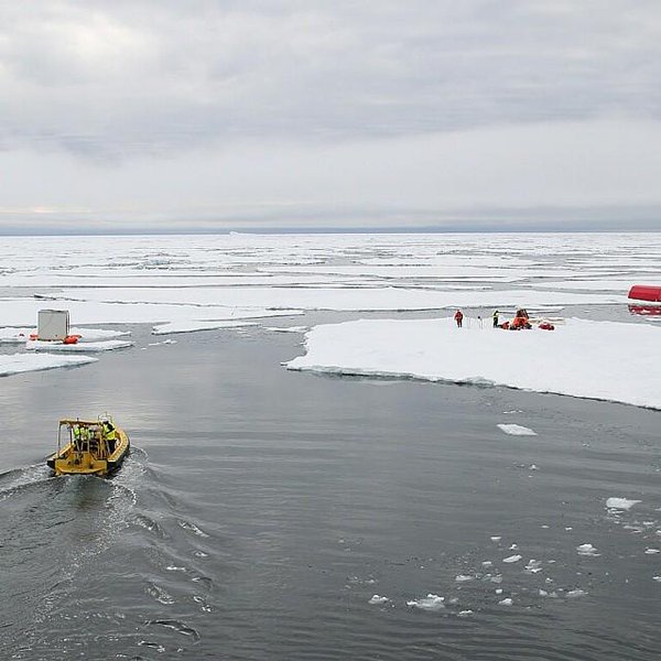
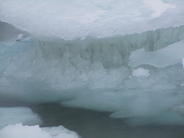
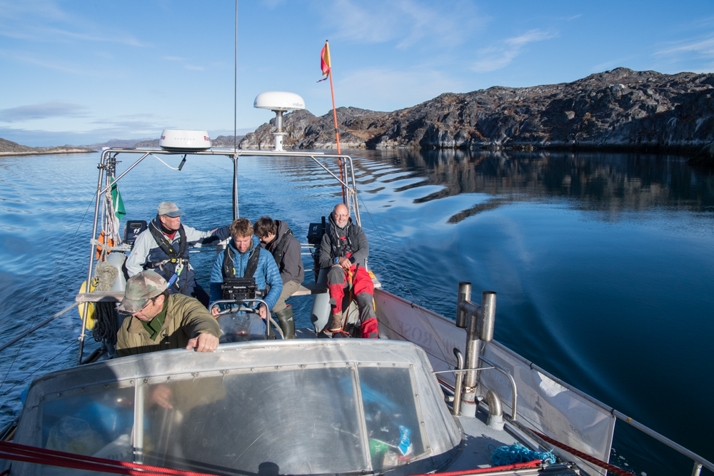
Some of the oldest, thickest ice in the Arctic has been chopped into small pieces which then easily flow through the channels of the Canadian Arctic Archipelago and into the Northwest Passage. Hence when the yacht Northabout (amongst others) was racing to reach Baffin Bay it wasn’t to avoid “the refreeze” as claimed in certain quarters. It was in fact to try and avoid the worst of the chopped up chunks of old sea ice being carried swiftly in their direction by winds and currents. Here’s what some of them looked like in close up:
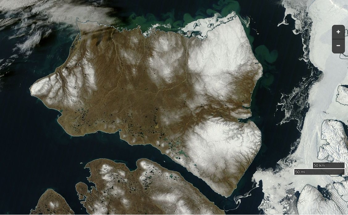
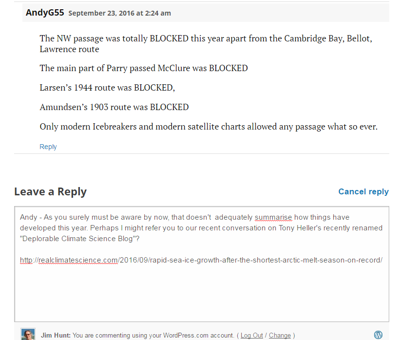
The next question then becomes, if the Northwest Passage wasn’t refreezing then, is it freezing now? The answer is not yet. In fact the favourite talking point of the cryodenialista, McClure Strait at the western end of the “main” route through the Passage has recently become navigable:
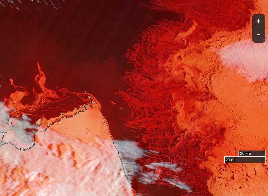
NASA Worldview “true-color” image of Banks Island on September 24th 2016, derived from the MODIS sensor on the Terra satellite
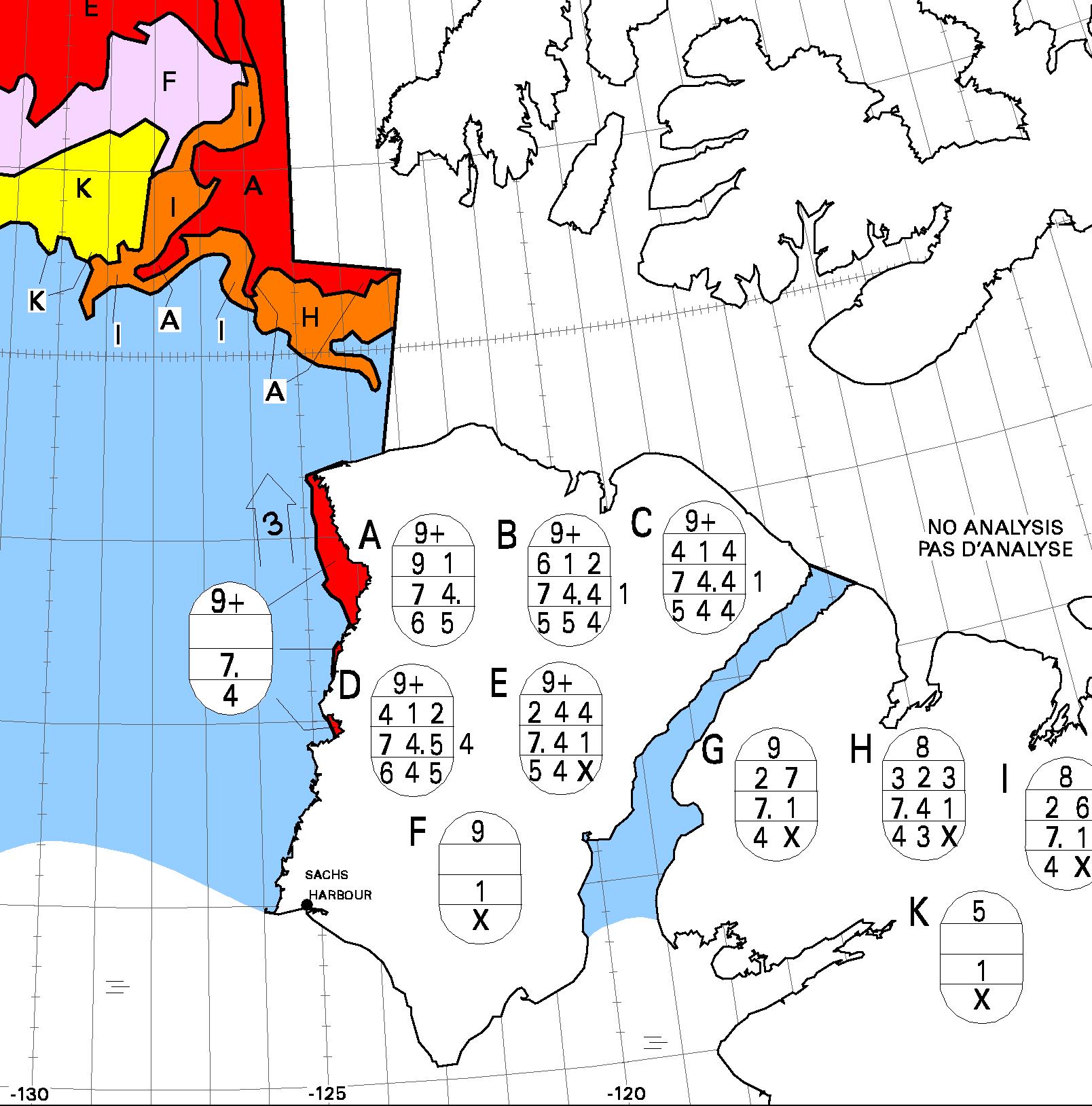
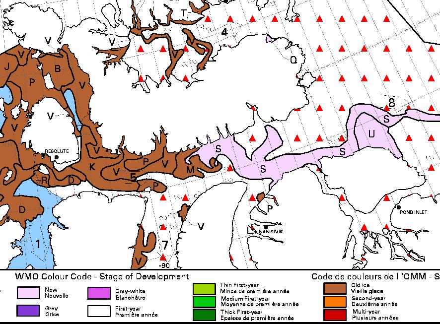
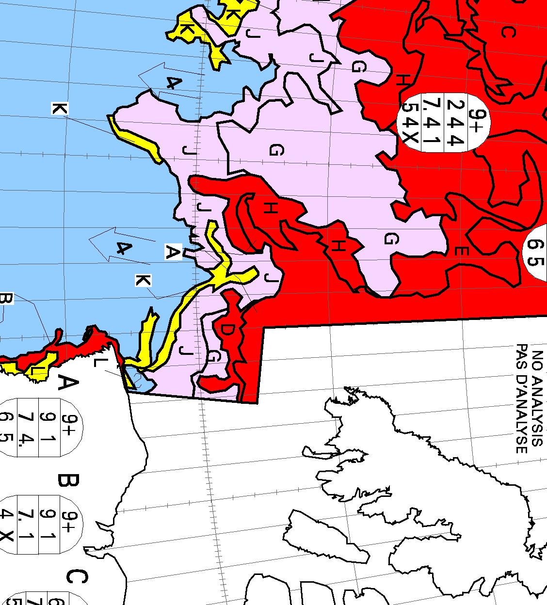
The “pretty pink” area towards the top left of the chart reveals “new ice”. The Northwest Passage will have started to refreeze when some of that shows up on a “stage of development” chart of the Passage itself, but that hasn’t happened yet. Here’s yesterday evening’s chart of the “Approaches to Resolute“:
Lots of old ice! It was raining in Resolute yesterday, and the old ice there was still melting:
[Edit – September 27th]
No sooner said than done! This evening’s ice charts from the CIS do now show some “pretty pink” new ice in the Northwest Passage:
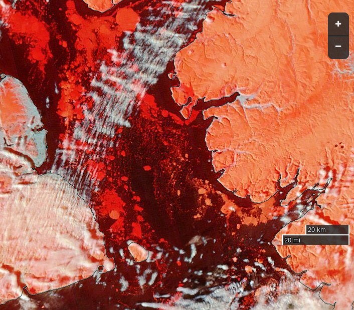
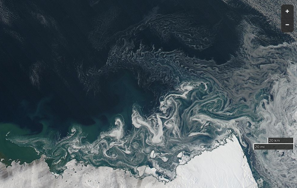
The wispy areas of new ice are also visible on this “false-color” image of the Parry Channel:
NASA Worldview “false-color” image of the Parry Channel on September 27th 2016, derived from the MODIS sensor on the Terra satellite
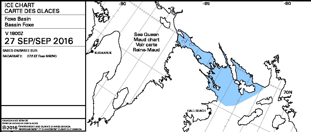
However even if Northabout were still in Prince Regent Inlet she wouldn’t be “trapped in ice”. There is still a way back to Bristol via Fury and Hecla Strait:
A clear view of McClure Strait from the Terra satellite in “false colour”:
NASA Worldview “false-color” image of the McClure Strait on September 30th 2016, derived from the MODIS sensor on the Terra satellite
The inclusion of some infra red reveals the thicker old ice on the right noticeably paler than the new ice to its left. Compare also with the CIS ice chart, which has been rotated to match the orientation of the satellite image:
[Edit – October 2nd]
Pretty patterns in the new sea ice forming at the western entrance to McClure Strait:
NASA Worldview “true-color” image of the McClure Strait on October 1st 2016, derived from the MODIS sensor on the Aqua satellite
The freshly frozen new ice in the Northwest Passage has been spotted by the AMSR2 instrument aboard the Japanese “Shizuku” satellite:
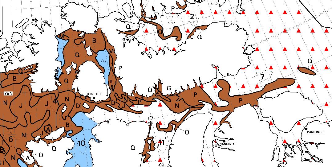
On the latest CIS “stage of development” chart the brown “old ice” has turned to deep red “multi-year ice”, and there’s lots more pretty pink out in the Beaufort Sea:
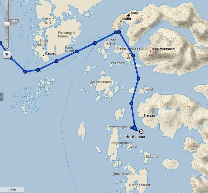
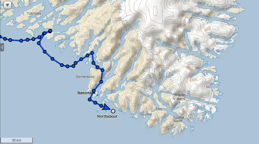
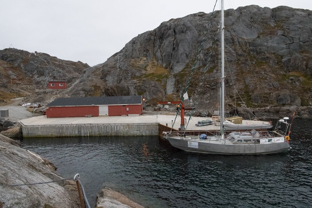
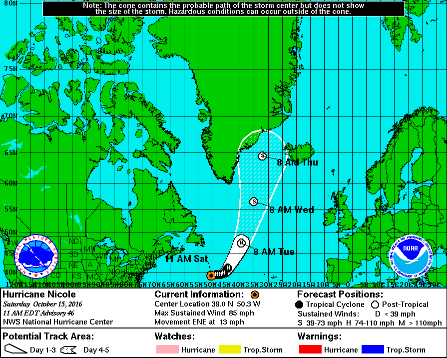
Following another crew change the Polar Ocean Challenge team in their yacht Northabout have just left Nuuk in Greenland, bound for Bristol in South West England:
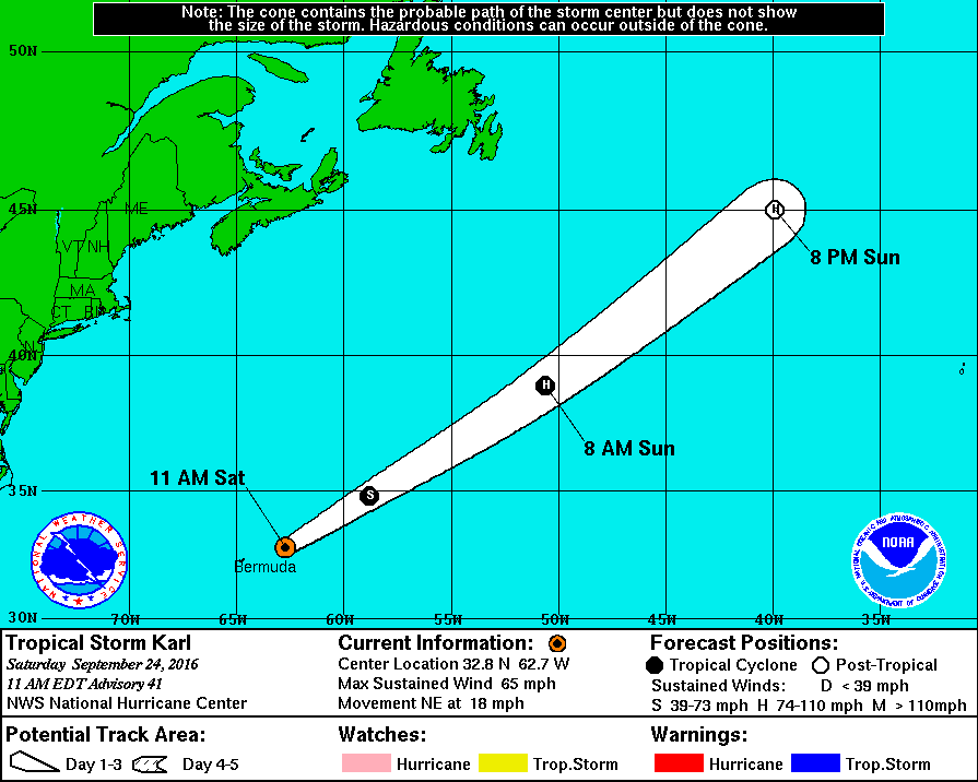
To get back to good old Blighty they are going to have to brave the North Atlantic in Autumn. Some stormy weather is likely! We’re currently keeping an eye on Tropical Storm Karl, who has just left Bermuda in his wake and is forecast to reach hurricane strength before heading off across the North Atlantic:
The latest advisory bulletin from the National Hurricane Center forecasts that:
Karl is forecast to be absorbed by an extratropical cyclone early Monday.
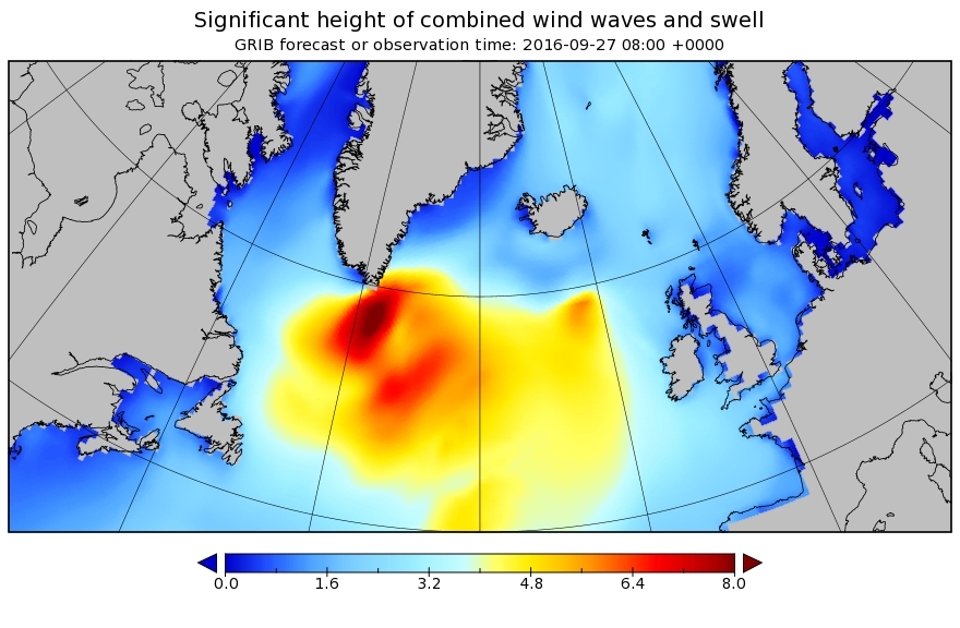
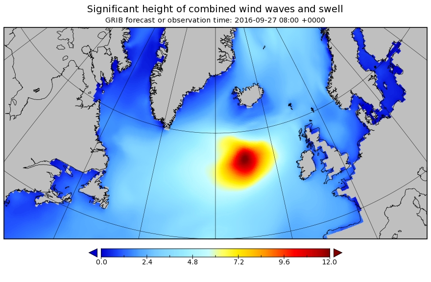
That cyclone looks set to create 8 meter waves south of Greenland! Here’s how the significant wave height forecast looks for 08:00 on Tuesday September 27th:
What happens after that remains to be seen. We will keep you posted!
[Edit – September 25th]
The new captain of Northabout, Mike Stewart, reports that:
We have decided to approach things in a relaxed manner, and for the first few days, at least, we will day sail southwards amongst the islets and channels towards our departure point, in a sort of ‘shake down’ period, to get used to each other and our vessel, we will head for a remote weather station on the very south east tip of this vast and forbidding Island. More to say on that later..
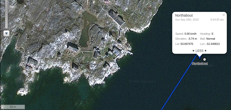
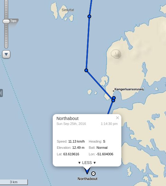
Our home for this, our first night, as a complete crew is at anchor next to a tiny abandoned port named FAERINGEHAVN. Old dead wooden whalers, ribs now showing, and sad broken down port buildings, minus roofs, are our view of the shore less that 50m away. Have a close look at the top of this image, or zoom in on the tracking on the satellite view.
We did just that:
which reveals that the new name for Færingehavn is Kangerluarsoruseq.
Mike also points out that they are not alone:
We have visitors! EAGLES QUEST II crew, (a Hong Kong registered Tayana 58 who have sailed from via Alaska), decided to tag along for a while are on their way over for a brew..
Given the storm that Karl is brewing up in their path a leisurely cruise to Cape Farewell seems like an eminently sensible idea to me!
[Edit – September 25th PM]
Northabout has now set off on the next section of her island hopping cruise to Cape Farewell:
[Edit – September 26th]
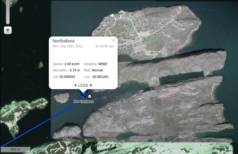
Northabout anchored for the night near Fiskenæsset (AKA Qeqertarsuatsiaat):
She has just set off hopping amongst a few more of the numerous islands off the south-west coast of Greenland:
The imminent storm swell is now forecast further out into the North Atlantic than two days ago, but has grown to a predicted 12 meters:
Note the change in scale!
[Edit – September 27th]
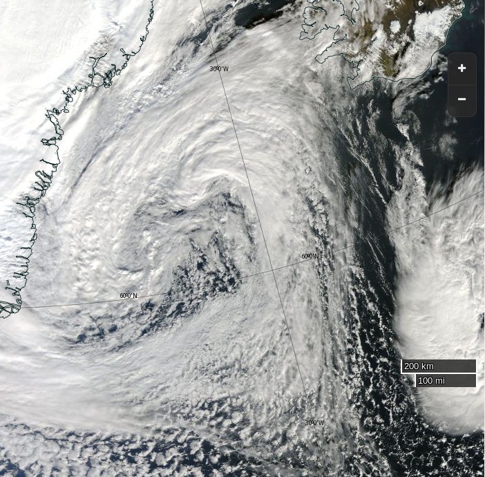
Here’s the storm currently raging in the North Atlantic:
NASA Worldview “true-color” image of the North Atlantic on September 27th 2016, derived from the MODIS sensor on the Aqua satellite
Northabout looks to have found a sheltered spot to stay the night:
It seems that her new crew have experienced plenty of fine weather recently. According to Ben Edwards:
This is ridiculous. Three days in a row and we’ve had the best weather of the entire trip. We woke up in the morning to relative warmth and clear skies our trip ashore to Qeqertarsuatsiaat was short but pleasant with a trip inside the local church.
Upon our return to Northabout we got the anchors up and motored off. We managed to get the sails up a couple of hours later and we’re now doing about eight knots. We passed a glacier earlier on which was a little odd. From where we sat it seemed huge. The head alone was several miles across. The strange thing was that it didn‘t seem to stretch down to the coast. We were fairly sure of this because we could see a line of what looked like stone between the ice and the water and there were no icebergs that we could see. If it was at the water one would expect bits to break off and form bergs. … So it seems likely that it never reached the coast.
Let’s hope that continues!
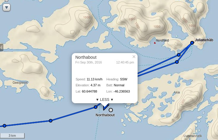
[Edit – September 30th]
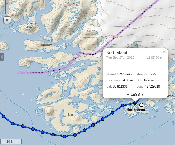
Northabout has just departed from Qaqortoq (AKA Julianehåb):
The Polar Ocean Challenge team have released a beautiful video of one of their recent sheltered spots to stay the night:
On their blog the current captain of Northabout, Mike Stewart, said yesterday:
We have successfully disembarked Steve and continued our preparation of Northabout for crossing the Atlantic. We have also re-fueled in situ courtesy of the Qaqortoq fuel supply truck, and have fitted a new house battery to bolster the hard working but a bit tired battery bank in place. This will keep our domestic amp draw supported- chart plotter, nav lights, interior lighting, electric pumps and bilge pumps etc working as they should. This also ensures that the engine start battery is kept fresh for its most important job.
I am told by the Inuit lady in the local chandlery that its going to blow hard tomorrow. We should have the wind behind us for our transit to the east, and then if all is ok run in to shelter mid afternoon.
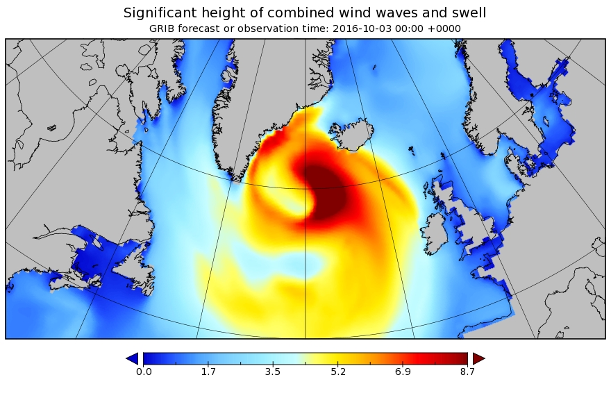
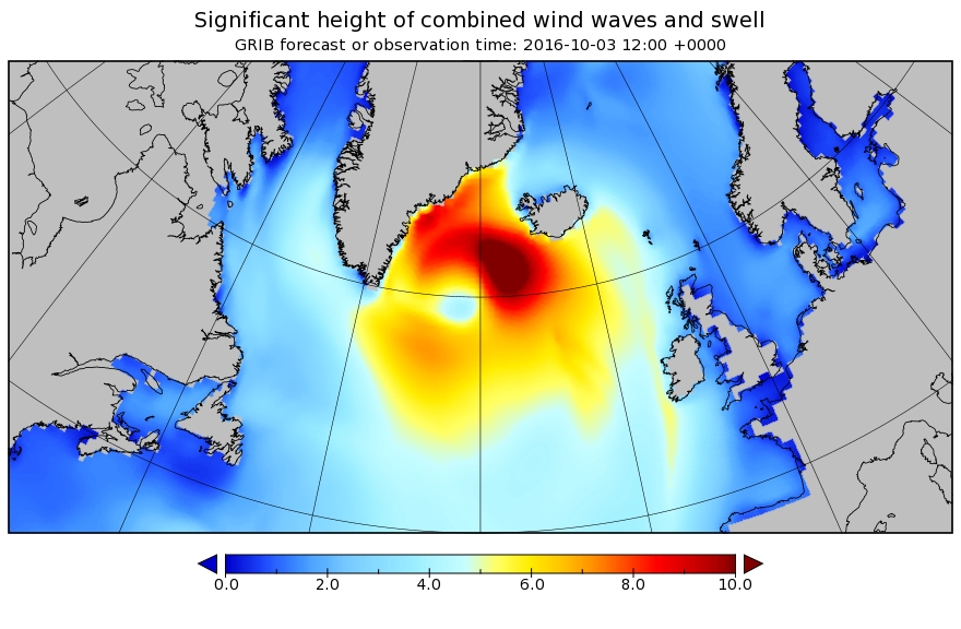
In actual fact it looks like it’s going to blow even harder in the not too distant future. Here is our North Atlantic “surf forecast” for 00:00 UTC on Monday October 3rd 2016:
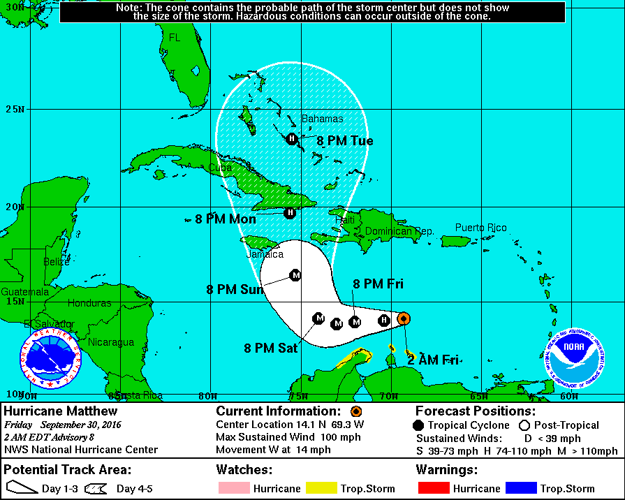
Meanwhile much further south in the Caribbean, Hurricane Matthew is forecast to become a major hurricane before reaching Cuba and then heading north across the Atlantic Ocean:
[Edit – October 1st]
Northabout is on the move again:
It seems my assumption that she would round Cape Farewell early next week was mistaken. According to Mike Stewart:
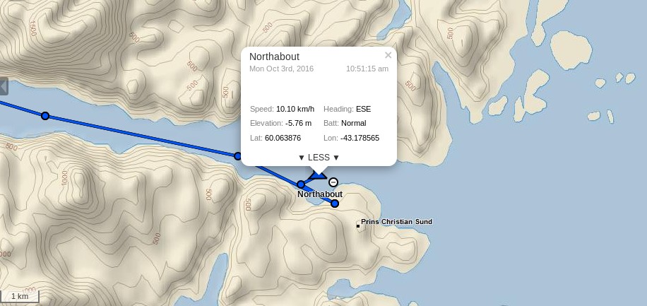
The strategy is to reach our departure point on the eastern entrance to PRINCE CHRISTIAN SOUND, which has a conveniently manned weather station and pier, in about two days sailing. This will allow us to hold in a safe area, whatever the weather in the Atlantic, and be in an ideal location to depart immediately to sea when the storm that is dominating the north Atlantic abates. After crossing Biscay 4 times this year, I have learnt that after a blow, kind of ‘riding on the back of it’ is an ideal time to head off. I recall something about the Chinese ideogram for chaos and opportunity being the same written character.. and as we have 3 Chinese sailors around half a mile behind us right now, I’ll use that to describe the general strategy I have in mind. Actually looks good for a Tuesday pm departure into decaying westerlies around 30-35 KTS.
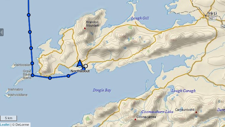
If you look at the map above the planned route will take Northabout through the islands of Southern Greenland, passing to the north of Christian IV Island.
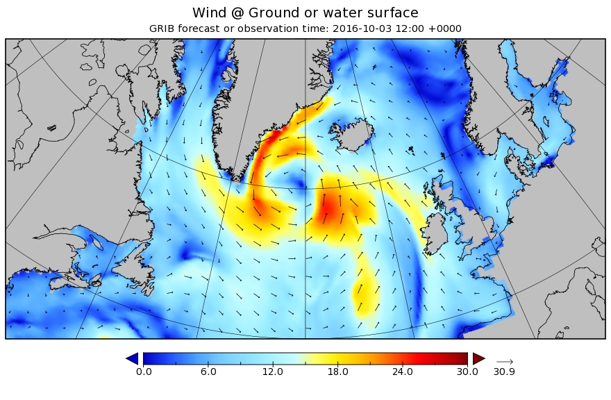
She is now heading in the direction of the Irminger Sea:
Beyond that the wilds of the North Atlantic beckon, where there is still a fair old storm raging!
It looks as though the Polar Ocean Challenge team are hoping to get a good head start on their voyage back to Bristol from the strong winds in the wake of that storm, but there’s also some big waves to contend with:
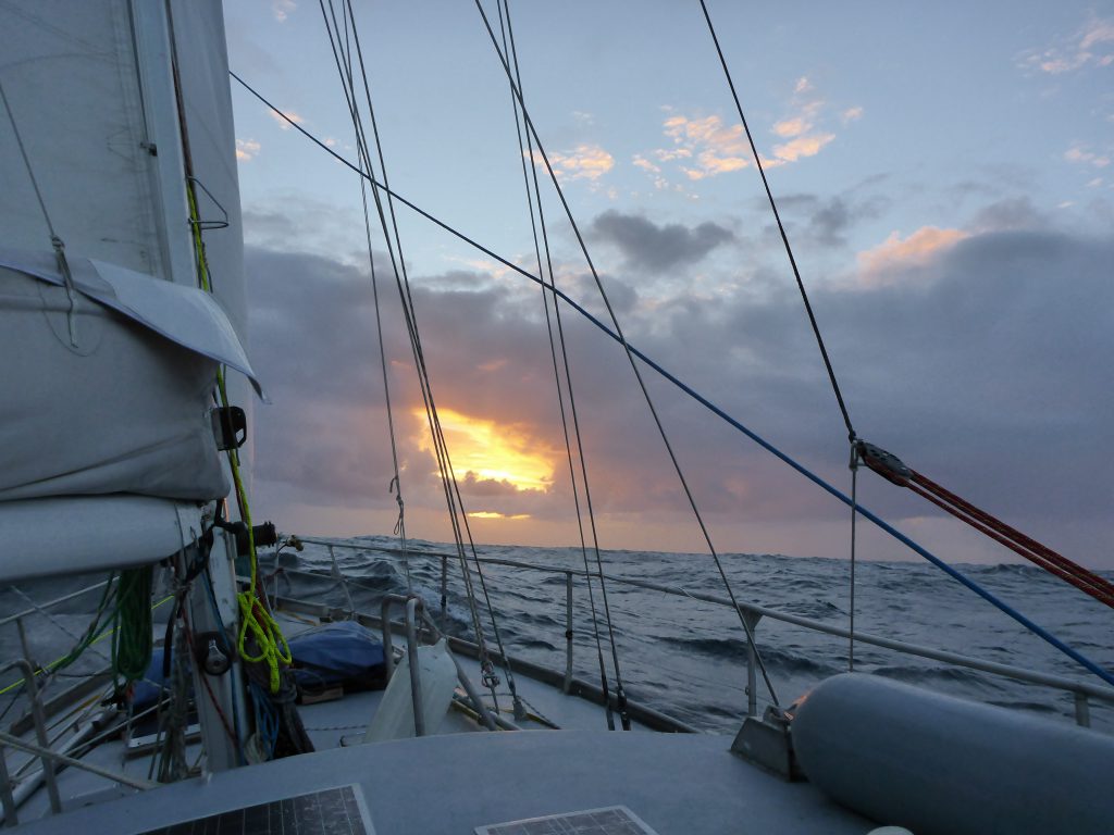
Differing accounts from Northabout in the stormy North Atlantic today! Skipper Mike Stewart reports that:
There is another low that will affect us in the next 24 hours, this will be through by tomorrow midnight, and most of its associated wind is westerly or northerly in our bit, anyway we take what we get here, its as simple as that. We have handled this at 50 KT with around 7m seas, (occasionally 8-9m) so our confidence levels are good. I heaved the boat to for a few minutes to test how she behaved, and she was ‘OK’ sitting duck like as the rollers powered through beneath us. During the evening, we were hit by one breaker, as always, theres a set bigger than the rest, and of course one broke over the boat, we were lifted and pushed sideways like a cork, but did not go over to any degree, which says volumes for our stability curve.
My first watch was from 1400 to 1600, and was quite an experience. I attached my harness before leaving the main cabin – I leave it permanently attached in the cockpit, a tip from a recent letter in Yachting Monthly – attached the second hook to another point near the wheel, and then took over from David. Looking around at the conditions a loud “Yeehaaar!” left my mouth and was whipped away by the wind. The seas were magnificent, lashed by the wind and spewing spume from the top, as Northabout gamely reached across the tops under reefed staysail.
So the night hath passed and we’re still alive. To me it feels like it was a bit of a close run thing…
I did my watch (eight to ten) and went straight to bed, not that that saved me. Twenty minutes later I rushed to the toilet and threw up my breakfast of porridge and tea. I then went back to bed, the swell got larger, the wind got stronger, I went back to toilet. This continued for the next ten hours. In total I threw up six times, a personal best.
Tomorrow is another day!
[Edit – October 8th]
David Wynne Davies reports from the middle of the North Atlantic:
Half way point to Ireland reached yesterday. Progress had been impeded by headwinds but with the wind now backed to the South and on the beam we were making 7kts. In order to catch up lost time the mainsail as well as the genoa were hoisted supported by the engine although increasing winds this afternoon (gusting 50kts squalls) prompted us to reduce to 3 reefs and a reduced staysail.
Everything then was cracking on beautifully in fairly rough seas – until the engine splutters and dies. Mike switched fuel tanks in the belief that the forward port tank may have been contaminated or be getting close to having to be switched over. Engine starts, but again stops suddenly. After further consideration the starboard fuel tanks were tested, and the engine started to run smoothly again. We will have to figure out why the port fuel tanks are not feeding through.
Last night to conserve fuel we stayed under sail started off making 5.5 kts. The wind is expected to ease over the next few days, and helpfully be on the nose when we cross the St George’s Channel. Let’s hope that the high pressure over UK moves away before then and that we can benefit from Westerlies.
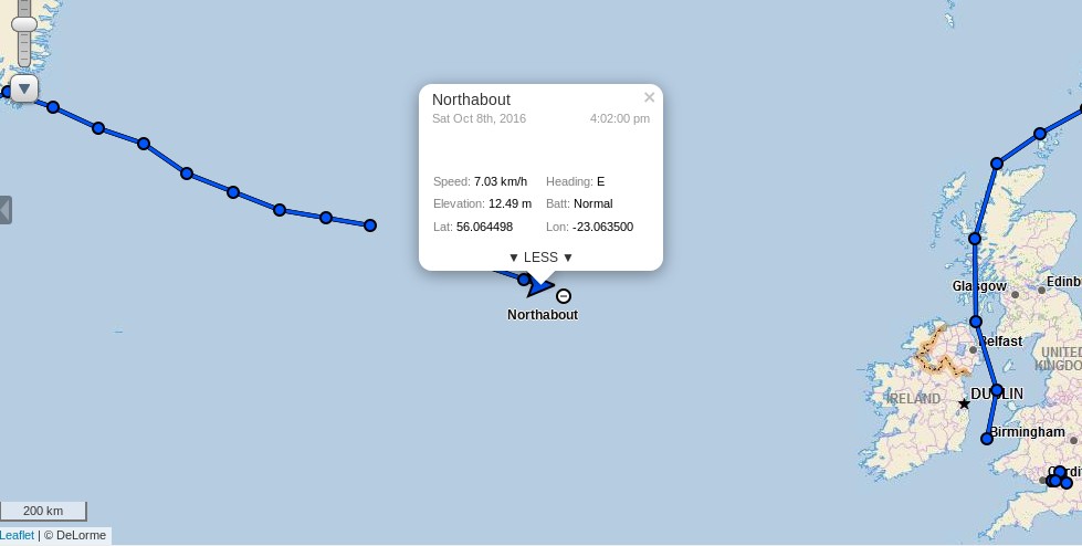
Possibly related to the spluttering engine, Northabout’s live tracking ceased to function for a while yesterday:
After an anxious wait it burst back into life, and confirms Northabout’s steady progress towards a welcome pint of Guinness in Ireland:
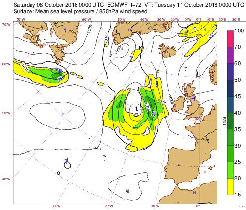
Here’s the ECMWF MSLP forecast for Tuesday morning revealing the approach of another low pressure system, which Northabout is no doubt hoping to avoid as far as possible:
[Edit – October 12th]
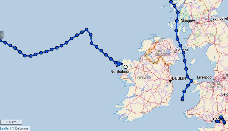
After a major, weather enforced detour:
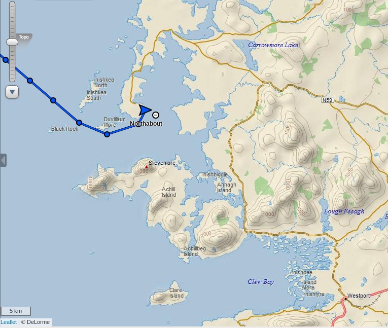
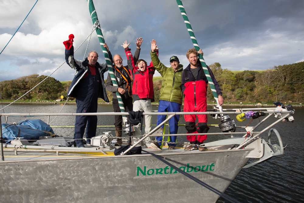
Northabout has just reached Ireland! After a recent blog post mentioned the town I thought they were heading for Clew Bay and Westport:
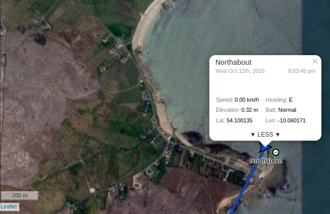
However they have stopped for the night north of there, at Blacksod Bay:
I hope there’s a hostelry available to serve the crew their longed for pints of Guinness. Then it’s on to Westport tomorrow.
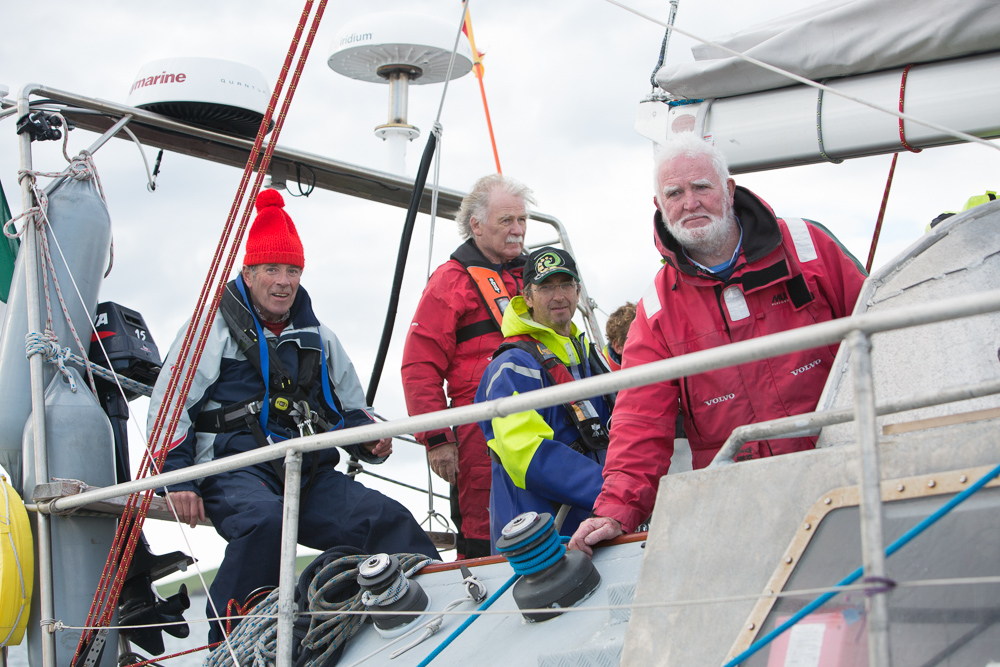
We arrived at Blacksod in darkness on Thursday evening to an unforgettable welcome from Jarlath, Mike, Tom and Mr Sweeney (the lighthouse keeper). Frances Gard was there too having hitched a lift after her Ryanair flight from Bristol.
With great enthusiasm they took our lines and promptly escorted us to a local hostelry. By golly, Guinness is indeed good for you at times like that! In true style, out came the fiddle and accordion with songs about Lord Franklin and other maritime disasters (all uplifting stuff!).
Yesterday we slipped Blacksod for Westport with Jarlath on board. Bringing Northabout back to Westport, where Jarlath had built her in 2001, was a poignant moment.
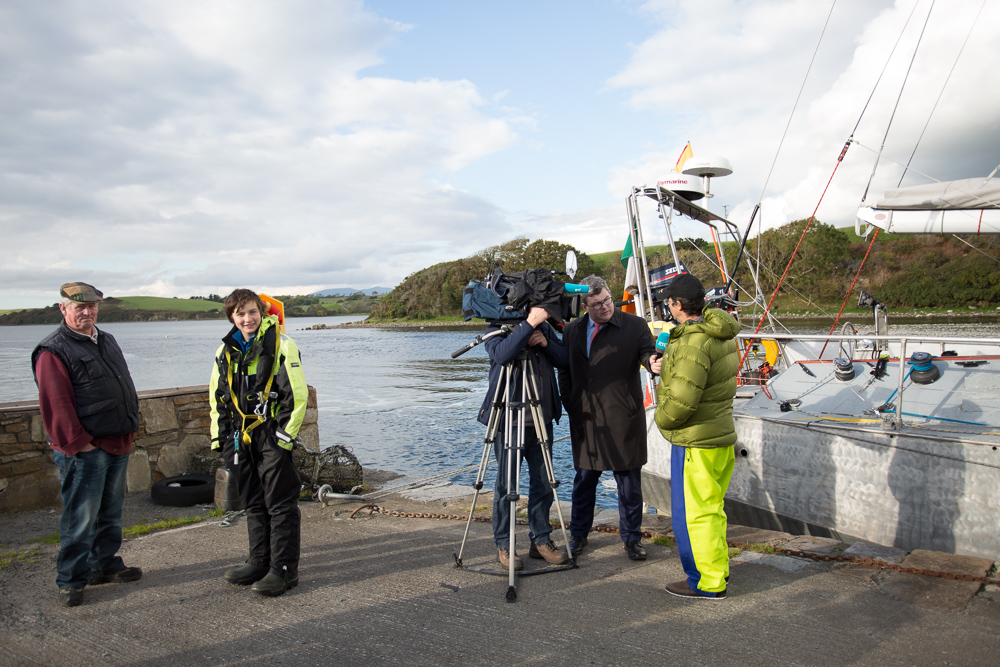
RTE News and several journalists were on the quay to record the event which was subsequently aired on the national TV news last night.
The sun is shining brightly again today although a front is expected tonight bringing heavy rain – but more importantly a wind shift. We leave for Dingle this afternoon after a most remarkable 36 hours during which we were treated to terrific hospitality. Many thanks to the hosting party who incidentally sailed Northabout through the NE and NW Passages over two seasons some years ago. So they fully recognise what this expedition had achieved.
[Edit – October 15th]
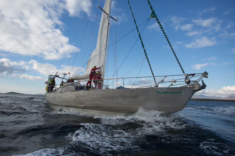
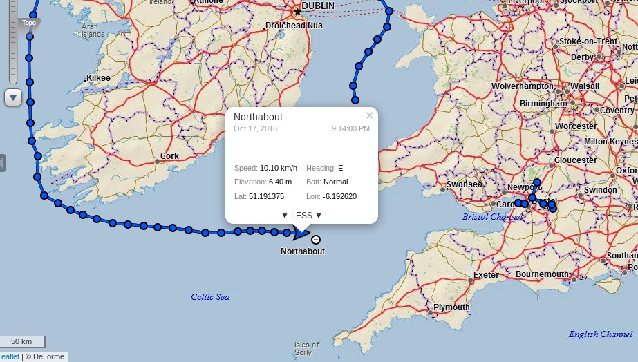
Having departed from Westport on yesterday evening’s high tide Northabout has now arrived in Dingle:
Beautiful morning, sun shining, a decent breeze from behind, and rolling down the Atlantic swells under full foresail at a steady 6kts, with bursts to 9kts if the waves pick us up. We are now well into the Celtic Sea, past Cork in the north, and enjoying the run home. We saw a dolphin last night, and four this morning so far.
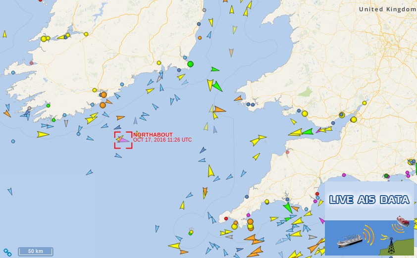
Skipper Mike is keeping us on our toes, with no relaxing – constant AIS watch, and looking out for boats without AIS on radar.
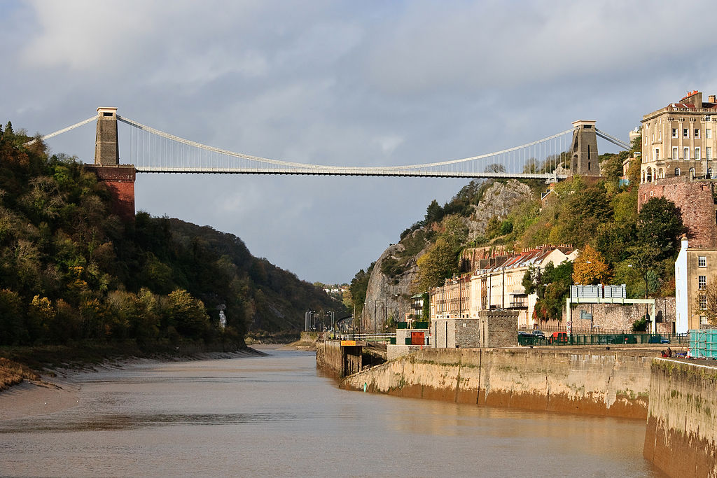
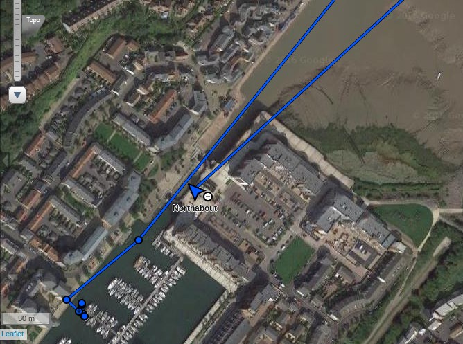
Assuming Northabout manages to safely avoid all the shipping in the Bristol Channel, on Thursday morning she is due to sail along the River Avon under Isambard Kingdom Brunel‘s Clifton Suspension Bridge:
With the wind and swell behind us we were doing twelve knots at times with an average of about seven. Amazingly that continued and continues to continue as we continue to head east.
Perhaps slightly ahead of schedule, Northabout has now arrived in Portishead:
The other blue line in the picture was recorded way back in June!
Halloween is a little way away still, but nonetheless I have a horror story to tell you. Are you sitting comfortably?
As our regular reader(s) will be aware we have been following the fortunes of the plucky little yacht Northabout on her Arctic circumnavigation with great interest. That includes the series of reports about the voyage on the BBC Radio 4 Today programme. Even recent passers by may have noticed that we were none too pleased with the most recent episode in the series!
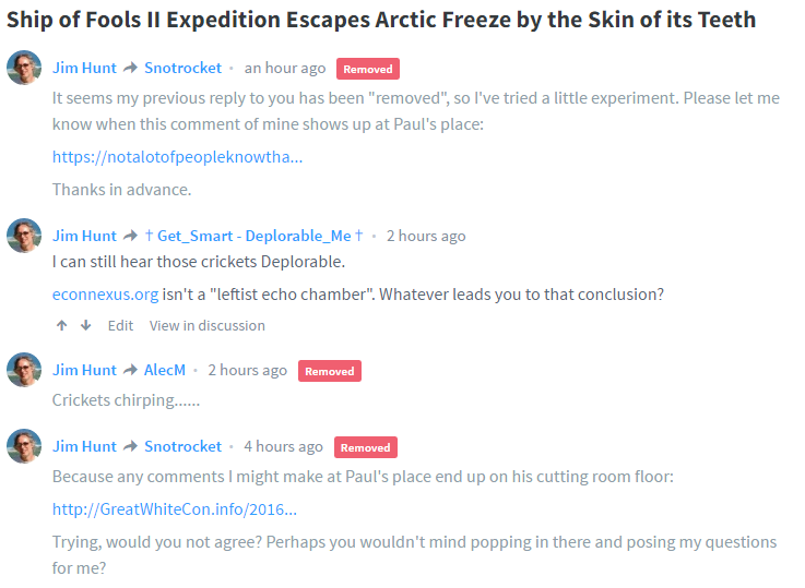
Now comes news that one of the numerous usual suspects has been blathering about both the Polar Ocean Challenge expedition and that BBC Radio 4 programme. Enter stage right James Delingpole at Breitbart. Under the catchy but erroneous headline:
The Polar Ocean Challenge expedition – aka Ship of Fools II – has escaped from the Arctic by the skin of its teeth. It was supposed to show how amazingly navigable the Arctic Circle has become now that climate change is supposedly melting the polar ice caps at a dangerous and unprecedented rate. But according to one observer who has followed their progress closely (see comments at Paul Homewood‘s place), the intrepid explorers – including a 14-year-old boy – came within just two days of calamity, after being hampered by unexpectedly large quantities of a mysterious substance apparently made of frozen water.
Regular readers will recall that not a lot of people know that Paul Homewood is the proprietor of a production line of porky pies full of horrifying Arctic anomalies. Mr. Delingpole references one batch of such Halloween howlers, wittily entitled:
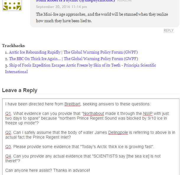
The southern NWP route is now closed at the NE exit, with northern Prince Regent Sound blocked by 9/10 ice in freeze up mode. Exactly where they barely made it through after hours of probing on 9/12. Northabout made it through NWP with just two days to spare. Had they taken the planned 2 days resupplying in Barrow rather than 1, and the planned one day call at Cambridge Bay (meeting up with Polar Bound), they would not have made it out and would have had to turn around and overwinter at Cambridge Bay. It was that close.
Now how can I put this politely? That is pure unadulterated balderdash. If Mr. Delingpole thinks that a comment on a known “snow blind” blog constitutes evidence of anything he needs one of his heads examined. Deconstructing all the mistakes in just this one article about both Northabout and the BBC’s climate change coverage will involve a series with more episodes than BBC Radio 4s! However we have to start somewhere, so let’s examine this assertion first shall we?
Paul Homewood notes… it’s also the earliest minimum since 1997, indicating that the Arctic is currently experiencing a very cold spell.
Some skeptical fellows over on Twitter disagreed with me about the facts of the matter. This is how that “debate” proceeded:
In other news Anthony Watts has today published a guest post about Arctic sea ice by one Caleb Shaw on his Watts Up With That blog. I thought I’d pose Paul and Caleb some relevant questions, but a team of Gremlins seem to have been hard at work stealing my pertinent comments before the assorted [mods] could approve them. By way of example, from Breitbart:
This website uses cookies to improve your experience. We'll assume you're ok with this, but you can opt-out if you wish. Cookie settingsACCEPT
Privacy & Cookies Policy
Privacy Overview
This website uses cookies to improve your experience while you navigate through the website. Out of these, the cookies that are categorized as necessary are stored on your browser as they are essential for the working of basic functionalities of the website. We also use third-party cookies that help us analyze and understand how you use this website. These cookies will be stored in your browser only with your consent. You also have the option to opt-out of these cookies. But opting out of some of these cookies may affect your browsing experience.
Necessary cookies are absolutely essential for the website to function properly. This category only includes cookies that ensures basic functionalities and security features of the website. These cookies do not store any personal information.
Any cookies that may not be particularly necessary for the website to function and is used specifically to collect user personal data via analytics, ads, other embedded contents are termed as non-necessary cookies. It is mandatory to procure user consent prior to running these cookies on your website.