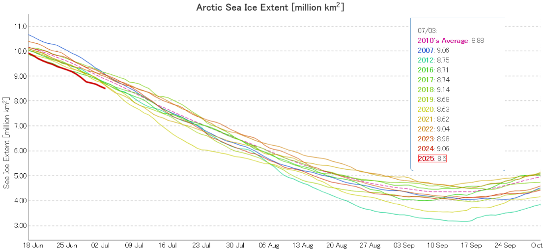
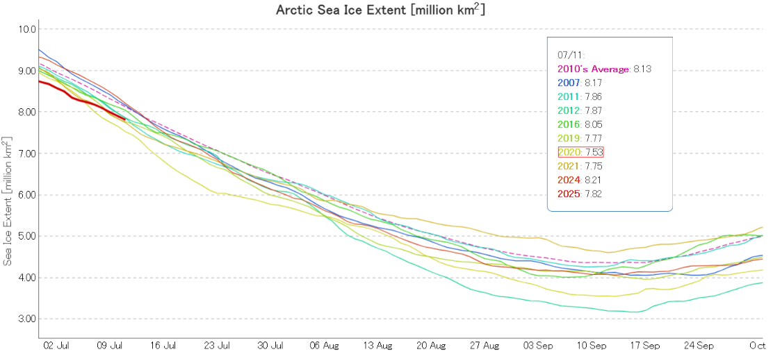
At the beginning of July JAXA/ViSHOP Arctic sea ice extent is still “lowest for the date” in their record going back to 1979:
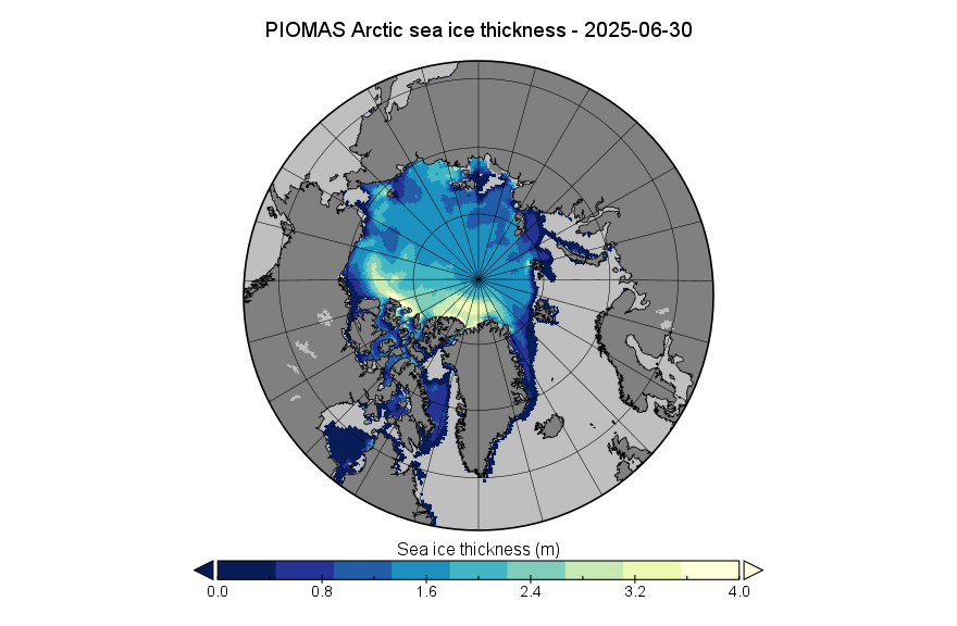
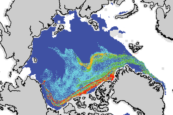
The PIOMAS sea ice thickness map for June 30th reveals that the previously thick ice in the Chukchi Sea has been noticeably thinning:
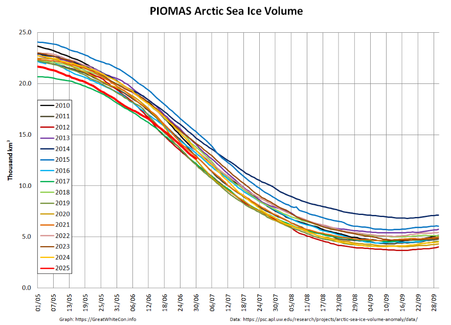
The associated volume graph shows that the 2025 curve has entered the pack of other recent years. and is now 4th lowest for the date:
In an all too brief reprieve for the NSIDC’s sea ice index, they have announced that their feed of SSMIS data will continue for another month:
Meanwhile the OSI SAF sent out an email today that reads as follows:
As an alternative to the OSI SAF sea ice concentration interim climate data record (SIC ICDR, OSI-430-a) based on SSMIS data, the OSI SAF sea ice team is preparing an equivalent ICDR based on AMSR2 data. This product, currently under development, is labelled OSI-438. This ICDR is based on the same processing chain as the existing AMSR2 climate data record (CDR, OSI-458), and some details of OSI-438 are available here:
https://osi-saf.eumetsat.int/products/osi-438
A processing chain has been set up for OSI-438, and is currently producing daily SIC ICDR product files for the northern and southern hemispheres, in the same projection and resolution as OSI-430 (EASE2 grid, 25km resolution). As for OSI-430-a, this includes nominal ICDR files with 16 days delay and fasttrack ICDR files with 2 days delay. OSI-438 has not been through the nominal validation and reviewing process yet, but due to the situation with SSMIS data coming to an end soon, we would like to make it available to users as a demonstrational product now that we find it mature enough for sharing. The product will become operational when validation and review is passed this autumn. During the demonstrational phase the product files are generated in our operational environment and will be made available on a best-effort basis. The production and product files might be updated if necessary. Any feedback on the products is very welcome.
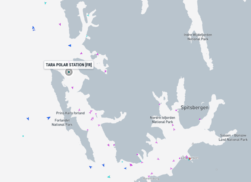
Finally, for the moment at least, the Tara Polar Station has left Longyearbyen and is heading northwards for a rendezvous with German icebreaker Polarstern before heading into the sea ice pack:
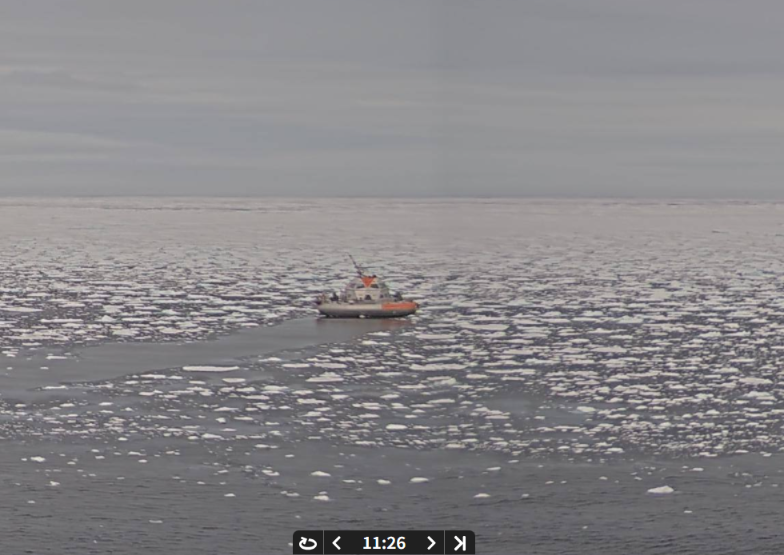
Polarstern has now met up with Tara, as evidenced by this image recorded by Polarstern’s webcam on Sunday:
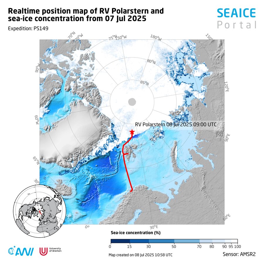
Here is Polarstern’s current position:
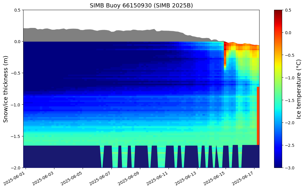
Taking another look at data from assorted ice mass balance buoys, 2025B stopped transmitting from the Chukchi Sea in mid June:
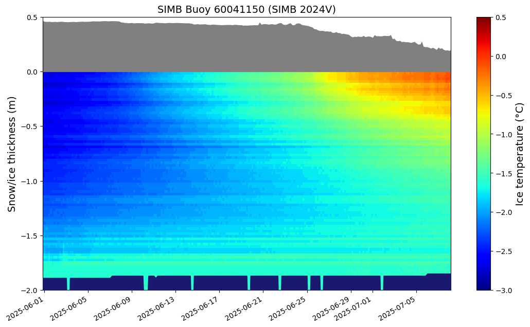
Buoy 2024V is currently located in the Central Arctic at 85.70 N, 108.07 W, where the snow cover is thinning and bottom melt has begun.
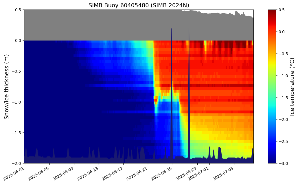
Buoy 2024N is located in the Lincoln Sea at 82.92 N, 56.47 W. It looks as though melting snow is trickling down the buoy’s mounting hole:
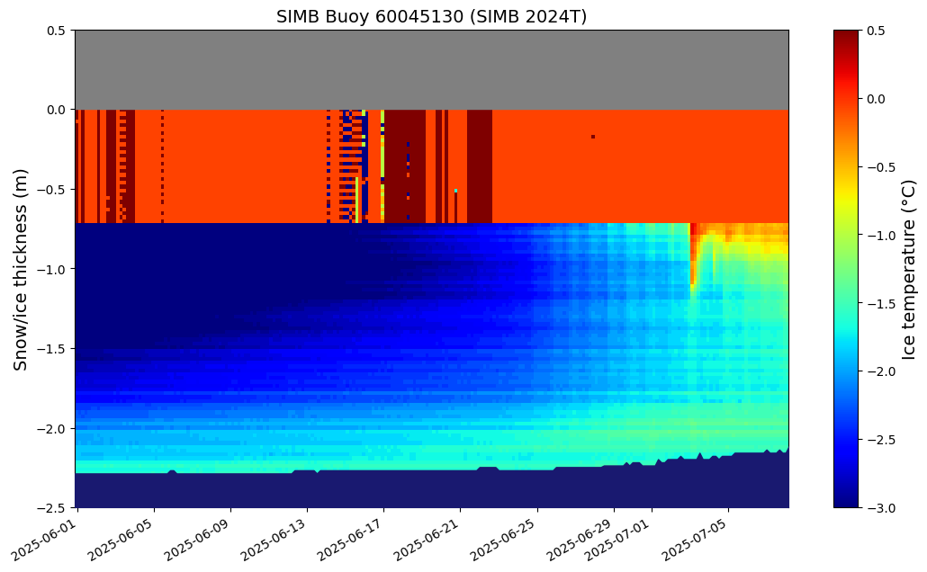
Some of the sensors on Buoy 2024T have failed. Nonetheless it is clear that bottom melt is well underway at 82.30 N, 160.40 W:
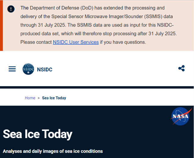
The National Snow and Ice Data Center has published the latest edition of “Sea Ice Today“, which contains this information:
There have been unrecoverable gaps in the delivery of sea ice data from the Defense Meteorological Satellite Program (DMSP) Special Sensor Microwave Imager/Sounder (SSMIS) source data. Moreover, NSIDC has been informed that the SSMIS data feed will be ending July 31…
With budget cuts from NASA for Sea Ice Today, we will no longer write mid-month analyses in the months leading up to the Arctic sea ice minimum…
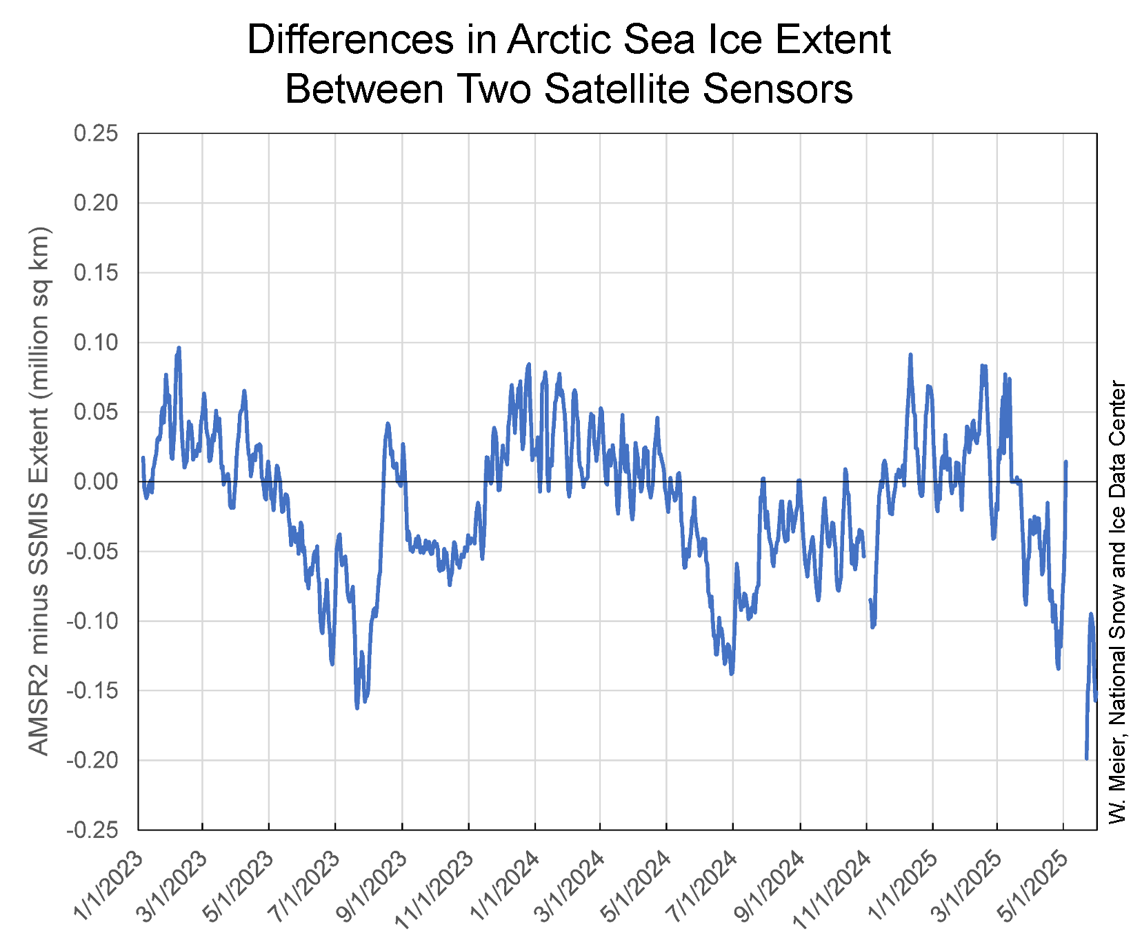
NSIDC is working on switching our primary data source to the JAXA Advanced Microwave Scanning Radiometer-2 (AMSR2). NSIDC has released a preliminary version. Sensor transitions always require adjustments to keep the derived product as consistent as possible. Switching to AMSR2 is challenging because for the first time in nearly 40 years there is a switch to a distinctly different sensor. AMSR2 has a larger antenna and thus higher spatial resolution as well as slightly different frequencies. The mismatch in resolution with SSMIS in particular requires detailed attention to preserve consistency, particularly for a threshold quantity such as sea ice extent. The intercalibration of AMSR2 data with SSMIS will be improved in the future and we will fully document our methodology. Initial assessment shows good agreement between extent estimates, but differences are larger during the Arctic summer melt season. This is always a difficult period because of surface melt water effects and the rapidly changing ice edge:
Getting back to the NSIDC’s traditional overview of the previous month:
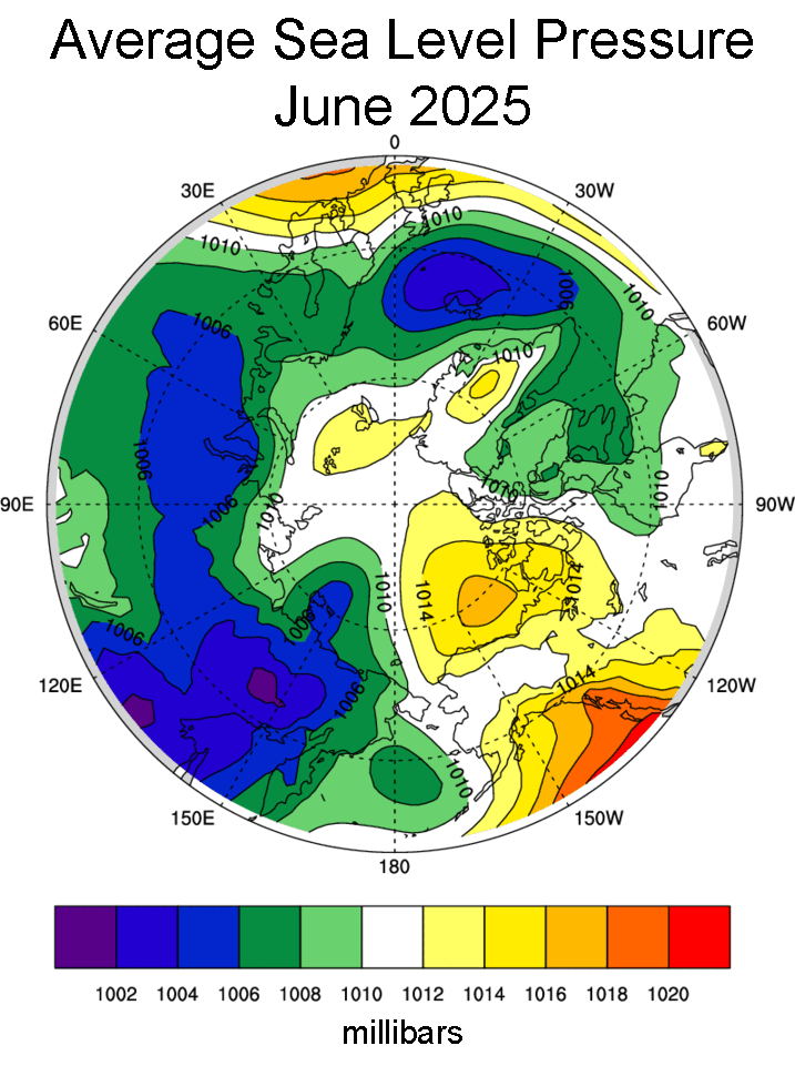
The sea level pressure pattern for June was characterized by a distinct Beaufort High north of Alaska, similar to the pattern observed in May. Lower pressure prevailed over the northern North Atlantic and extended across Eurasia:
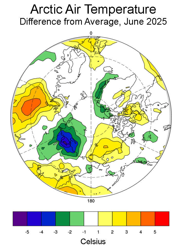
Air temperatures at the 925 millibar level (about 2,500 feet above sea level) were 2 to 3 degrees Celsius above the 1981 to 2010 average in the region of the Beaufort High. By contrast, it was relatively cool in the Laptev and East Siberian Seas, where temperatures were nearly 4 degrees Celsius below average:
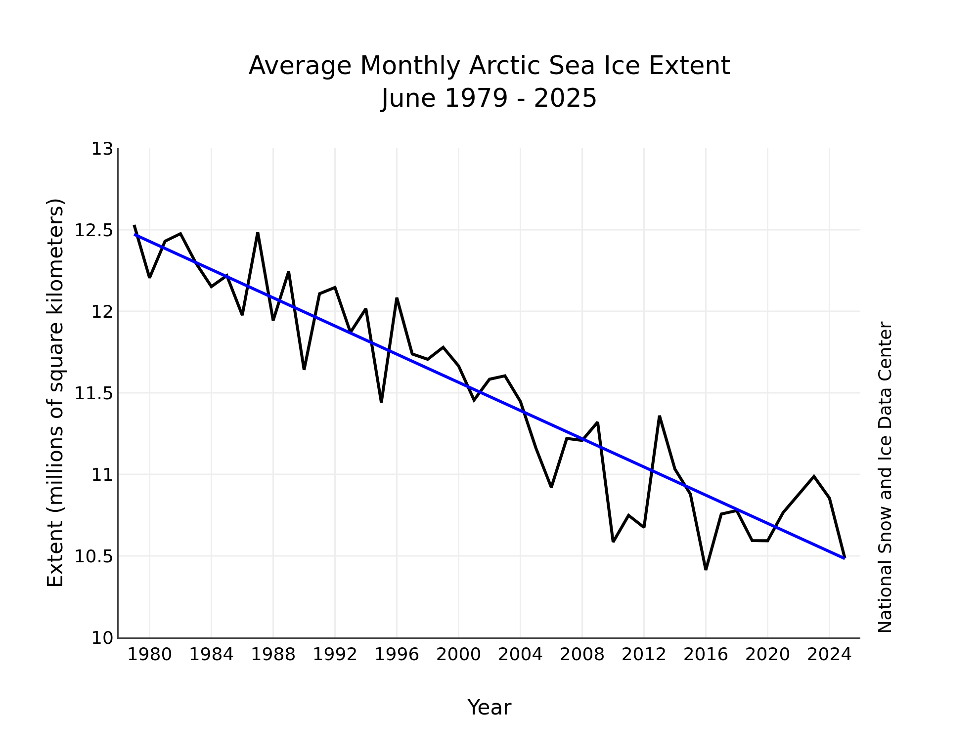
The downward linear trend in Arctic sea ice extent through 2025 for June is 43,300 square kilometers per year or 3.7 percent per decade relative to the 1981 to 2010 average. Based on the linear trend, since 1979, June has lost 1.99 million square kilometers of sea ice. This is equivalent to nearly three times the size of Texas.
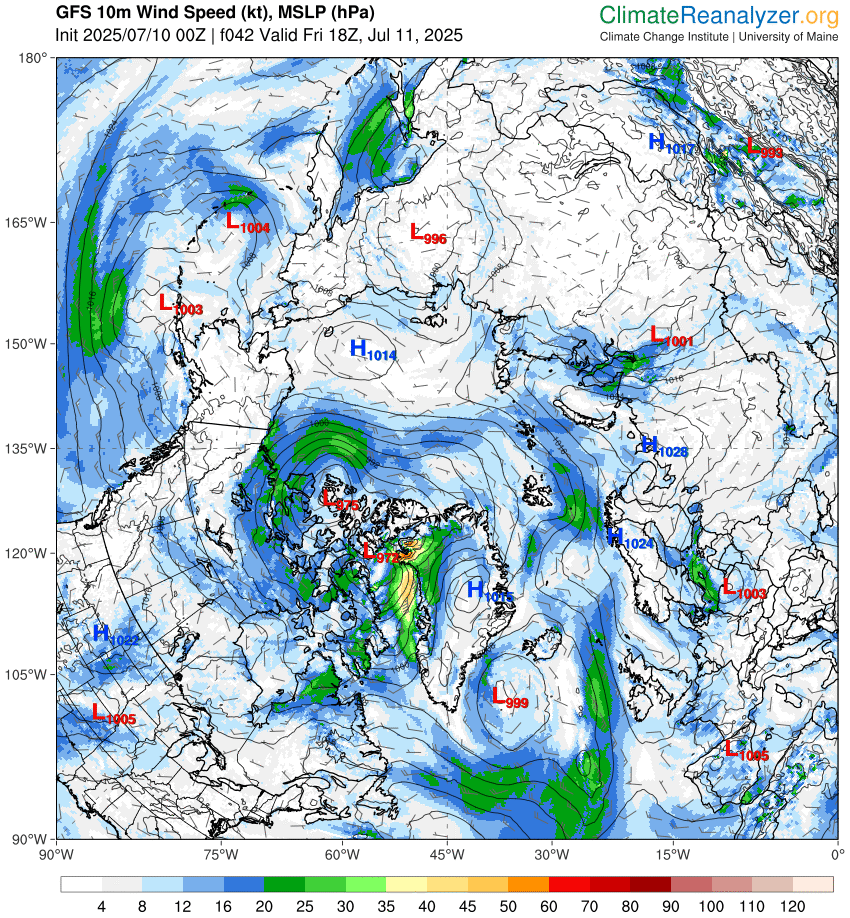
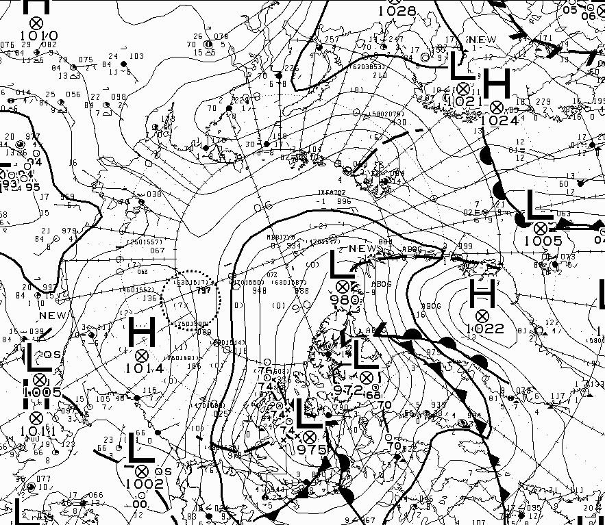
A cyclone is currently crossing the Central Arctic Basin. According to the Canadian Meteorological Centre the cyclone bottomed out at 978 hPa at 12:00 UTC yesterday:
According to GFS it’s going to deepen again as it reaches the Canadian Arctic Archipelago tomorrow:
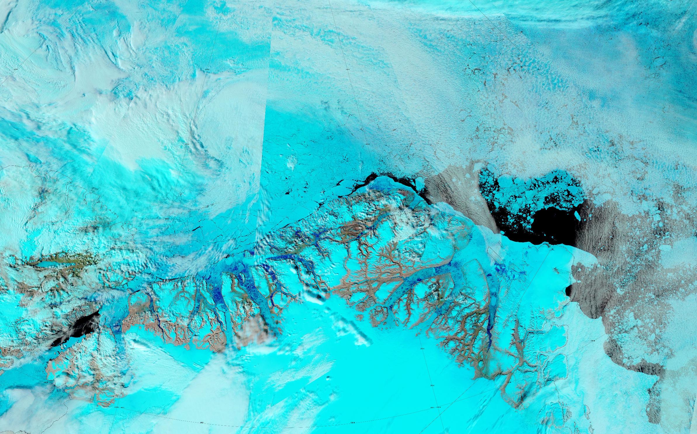
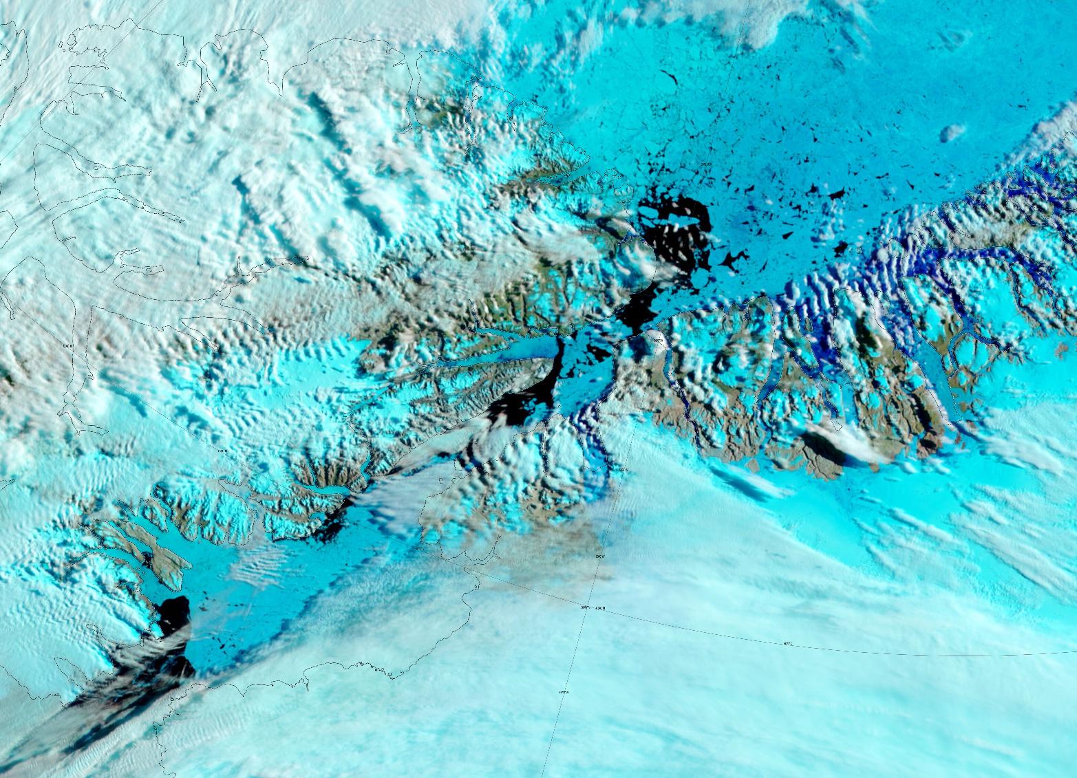
In other news from the Central Arctic, there was a fairly clear view of the state of the sea ice north of Greenland from on high yesterday:
According to the CMC the cyclone bottomed out at 974 hPa near the CAA coast. The central MSLP then stayed at that level for at least 12 hours as the cyclone crossed the archipelago, before rising by one whole hPa by 6 AM UTC this morning
In other news, JAXA extent has gently drifted into the pack of previous years. It is now 4th lowest for the date, just under 300 thousand km² above 2020:
Here too is the NSIDC’s Arctic sea ice age map for the end of June:
The northern section of the Nares Strait is crumbling, but somehow the remnants of a southern arch are still preventing the free flow of ice south from the Lincoln Sea:
The conversation continues on the August open thread.
“Note: With the end of SSMI/S data processing now scheduled for the end of July, we will need to change our source of sea ice concentration data that is assimilated into PIOMAS. We are still evaluating options. There is likely to be a data gap to occur.”
What that last sentence means is, PIOMAS will most likely not provide any sea ice volume numbers for August 2025, and possibly also for September/October.
In other words, should the Arctic go record low this summer, then no one will know. I bet that decision by the PIOMAS team will be popular over at 1600 Pennsylvania Avenue.
I suppose if Piomas hits a record low, JAXA won’t be far behind… A lot depends on how the Pacific side fairs in the next month or so
The NSIDC has said it is in the process of switching to using AMSR2 data, and so has the OSI SAF.
There’s no excuse for the PSC@UoW not to follow suit?
Jim, I’m worried because they are clearly stating a full 26 days – almost 4 weeks – ahead of the deadline, that “There is likely to be a data gap to occur”.
This implies that they themselves view it as acceptable for there to be the first ever data gap, after 46 1/2 years of daily volume data. And even though the AMSR2 data is higher resolution, and therefore trivial to automatically transform to US low-resolution standard data.
If I ran the ship, the manager who publicly said data gaps were likely, and thus acceptable, would immediately have been relieved of his duties.
Jim,
I believe Piomas will consider publishing their own Piomas numbers for June over the weekend!
No such luck yet, Jim, I’m afraid. That is, the team may still be considering pushing the Publish button, but no firm decision to do so has been reached, as of yet.
So I just checked out of curiosity, and lo-and-behold, not only was there no half-month update from Piomas in July, there hasn’t been one for about a year, but not only that, per August 1st the latest day of sea ice is May 31.
And that’s just the problems they made for themselves. Going forward, they’ll also have lack of input data to blame (not that they needed an excuse)…
Here’s to hoping new/better satellite & AI based sea ice volume services will soon come online!
The monthly update usually comes out around the 4th, so I wouldn’t despair just yet
PIOMAS, NSIDC et al. have received a last minute reprieve:
For the record: The 4th of July was one month ago. If they chose to skip June, and they did choose to skip June, who says they won’t choose to skip July as well?
Check out “Polar Python” , you’ll find the most up to date data there.
I kinda like changing the subject (“Is Piomas able to publish their own data after two-three months?”) to random other subjects, so I’ll raise you to Ella sailing into Pond Inlet this afternoon.