Tag Archives: NSIDC

The United States’ National Snow and Ice Data Center

Steve Koonin’s Unsettled Arctic Science

Regular readers of this blog will no doubt have realised that way up here in the Great White Con Ivory Towers we concluded many moons ago that Arctic sea ice is the “canary in the climate coal mine”.

Unlike some others we have already mentioned we were not the beneficiaries of a review copy of Steven E. Koonin’s new book, catchily entitled “Unsettled: What Climate Science Tells Us, What It Doesn’t, and Why It Matters”. Hence I was compelled to acquire my own review copy, and have just purchased the electronic version. I eagerly searched the virtual weighty tome for the term “Arctic sea ice”, and you may well be wondering what I discovered?

Nothing. Nada. Zilch. ничего такого. Nic.

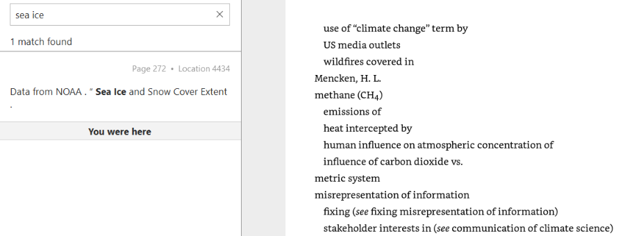
I broadened my thus far vain search by removing the “Arctic” specifier, which revealed:

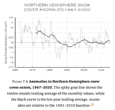
No mention of “sea ice” in the body of the book, merely a reference to the data underlying this graph of northern hemisphere snow cover:

I am forced to an unsettling conclusion. Evidently there are some areas of climate science that Dr. Koonin tells his eager readers nothing whatsoever about. It seems likely that he is also well aware that Arctic sea ice is the canary in the climate coal mine, which is why he has chosen to make no mention of it in his magnum opus.

Here is an informative video which will no doubt not appear in “Unsettled – The Movie”:

[Edit – May 8th]

Having now had time to read some of Steve Koonin’s “Unsettled Climate Science” at greater length I have discovered that it does contain one reference to Arctic sea ice, albeit using non-standard terminology. On page 40 of the Kindle version of the book I read:

Rising temperatures at the surface and in the ocean are not the only indicators of recent warming. The ice on the Arctic Ocean and in mountain glaciers has been in decline, and growing seasons have been lengthening slightly. Satellite observations show that the lower atmosphere is warming as well.

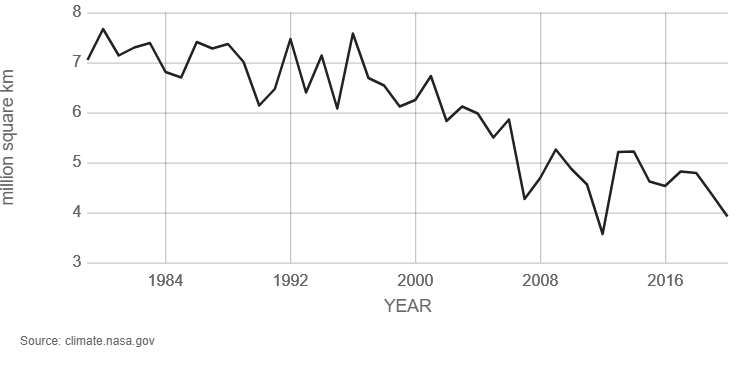
A paragraph I can broadly agree with, but I am compelled to ask why Dr. Koonin does not quantify the “decline of the ice on the Arctic Ocean” anywhere in the book? There are a wide variety of metrics used to quantify the “amount” of sea ice in the Arctic, but here is one readily available for download from the NASA web site. It is hard to believe that a scientist of Dr. Koonin’s experience, particularly one writing about climate change, has never previously come across a similar graph of Arctic sea ice extent:

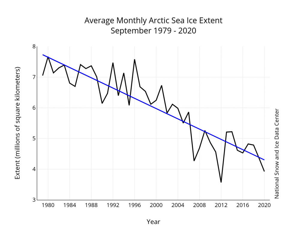
Arctic sea ice reaches its minimum each September. September Arctic sea ice is now declining at a rate of 13.1 percent per decade, relative to the 1981 to 2010 average. This graph shows the average monthly Arctic sea ice extent each September since 1979, derived from satellite observations.

It seems safe to assume that Dr. Koonin has heard of NASA, since the organisation is mentioned several times in his list of references and once in the body of the book. However it seems that the United States’ National Snow and Ice Data Center (NSIDC for short) is not very visible on his personal radar screen, meriting only a single reference which is to snow rather than ice data.

Here is the NSIDC’s version of the NASA graph above, which includes a handy trend line:

Monthly September ice extent for 1979 to 2020 shows a decline of 13.1 percent per decade.

Nearby Steve has penned another paragraph I can broadly agree with. On page 36 he states:

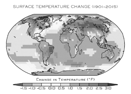
The warming of the past forty years on large scales hasn’t been uniform over the globe. That’s evident in Figure 1.5, reproduced from the US government’s 2017 CSSR (Climate Science Special Report, described earlier). As you can see, the land is warming more rapidly than the ocean surface, and the high latitudes near the poles are warming faster than the lower latitudes near the equator.

Here is the figure 1.5 referred to above:

Surface temperature change (in °F) for the period 1986–2015 relative to 1901–1960. Changes are generally significant over most land and ocean areas. Changes are not significant in parts of the North Atlantic Ocean, the South Pacific Ocean, and the southeastern United States. There is insufficient data in the Arctic Ocean and Antarctica to compute long-term changes there.

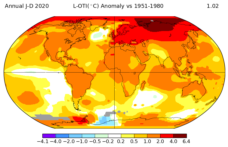
Once again I am compelled to ask some questions. Why not include a map that uses more recent data than 2015? And why not quantify how much faster the “high latitudes near the poles are warming than the lower latitudes near the equator”?

NASA helpfully provide an interface to their data which allows anybody who can click a mouse to produce their own global surface temperature maps. Here is the up to date answer to the first question:

NASA have also produced another informative video, which I suspect will also never make it into “Unsettled – The Movie”:

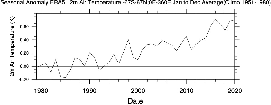
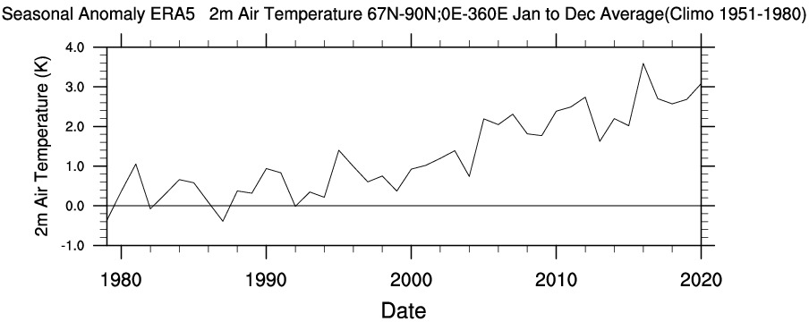
Another US scientific agency that provides publicly accessible climate data is the National Oceanic and Atmospheric Administration (NOAA for short). The abbreviation is referred to several times in Steve Koonin’s book, but for some reason he never expands the acronym in full. Like NASA they also provide a means to produce your own maps and time series. Albeit with a somewhat more complex user interface, the Web-based Reanalysis Intercomparison Tool (WRIT for short) allows the user to differentiate between different regions of Planet Earth, and hence answer the second question above.

Please compare and contrast the “non polar” temperature time series with the “Arctic” one. Note the change of scale of the X axis, and also the units. Degrees Kelvin rather than degrees Fahrenheit which are seemingly preferred by Dr. Koonin:

To summarise, you don’t need to wait for Steve Koonin to write another book or for the US government to produce another CSSR. Vast amounts of data and a plethora of visualisation tools are freely available to allow you to do your own research regarding a wide variety of climate metrics. Steve neglects to impart that information to his readers as well.

[Edit – May 9th]

As has been alluded to above, in the soon to be shipped hardcover edition of his new book Steve Koonin makes much mention of “snow cover” whilst ignoring “sea ice” entirely. There are also a grand total of 48 reference to the perhaps overly esoteric term “albedo“. On page 84 of the Kindle edition of “Unsettled” we are reliably informed that:

Among the most important things that a model has to get right are “feedbacks.”

Despite that the entire electronic volume makes no mention whatsoever of the phrase “ice-albedo feedback” or any synonym thereof. A brief course teaching the topic has recently been developed as part of the outreach activities of the MOSAiC Arctic drift expedition. Perhaps Dr. Koonin would be well advised to read it at his earliest convenience?

The ice-albedo feedback is an example of a positive feedback loop. A feedback loop is a cycle within a system that increases (positive) or decreases (negative) the effects on that system. In the Arctic, melting sea ice exposes more dark ocean (lower albedo), which in turn absorbs more heat and causes more ice to melt…the cycle continues.

Here’s another explanatory video which will also no doubt never make it into “Unsettled – The Movie”:

Watch this space for further revelations about the gigantic Arctic canary in the room!

Facts About the Arctic in May 2021

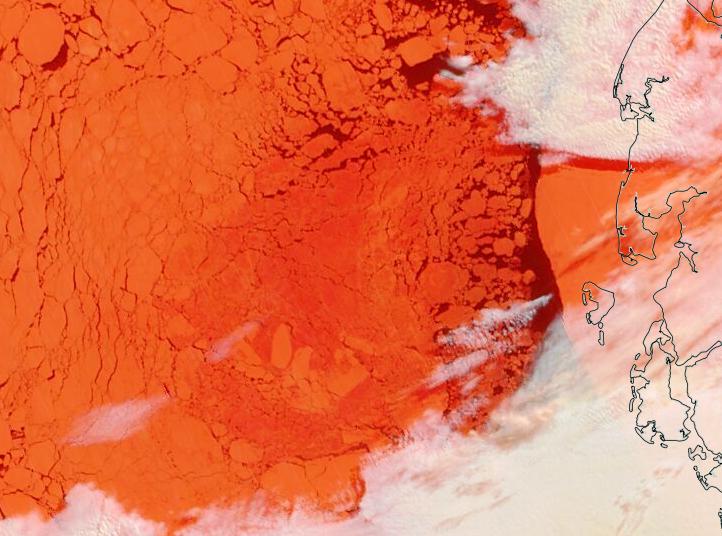
It’s May Day 2021, and just for a change we’re going to start the month off with a pretty picture!

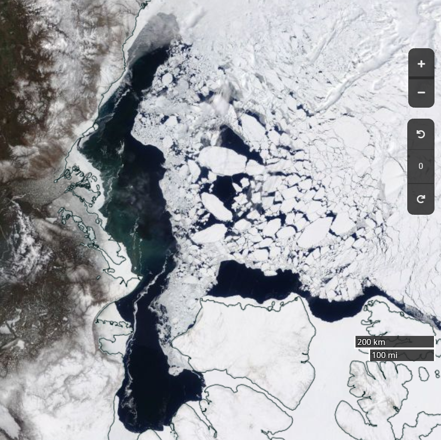
Parts of the Laptev Sea are starting to look distinctly “warm” in the infra-red. Here’s a “false colour” image taken by the Terra satellite during a gap in the clouds:

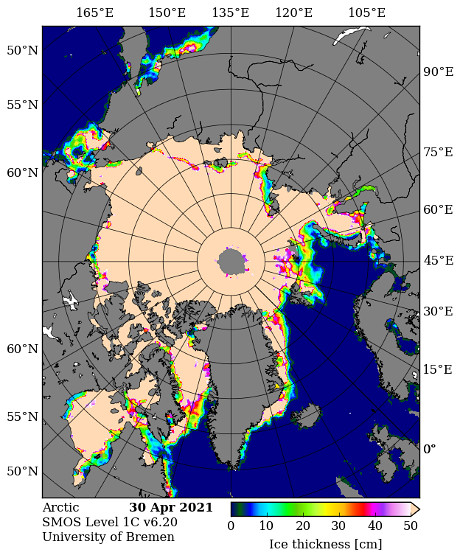
We have reached the time of year when the SMOS “thin ice thickness” readings start being affected by surface melt, but let’s take a look anyway:

That area of the Laptev certainly appears to be either thin or melting.

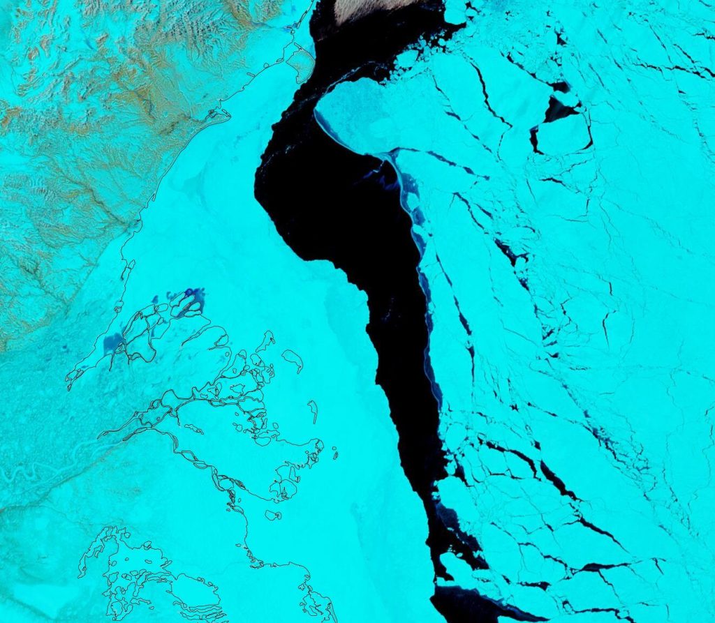
Meanwhile on the Canadian side of the Arctic the fast ice off the Mackenzie Delta is starting to get damp, even though the river itself still looks to be fairly well frozen:

It will also be interesting to follow the progress of this large floe as it heads towards oblivion through the Fram Strait:

Continue reading Facts About the Arctic in May 2021

The 2021 Maximum Arctic Sea Ice Extent

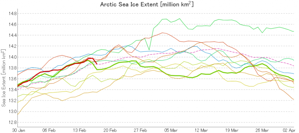
Here’s the latest graph of Arctic sea ice extent from JAXA/ViSHOP, with 2021 and 2015 highlighted:

Extent fell by over 100,000 square kilometres between February 16th and 17th! Can that steep fall continue, as it did for one more day in 2015?

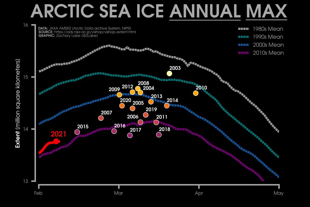
Here too is Zack Labe’s 2021 overview of JAXA maximum extent over the previous couple of decades:

2015’s maximum was very early, on February 15th. Hence the current extremely tentative 2021 maximum is already both higher and later than that. The decadal average extent graphs show the date of the maximum getting later and later, and the 2010’s peaks in the middle of March.

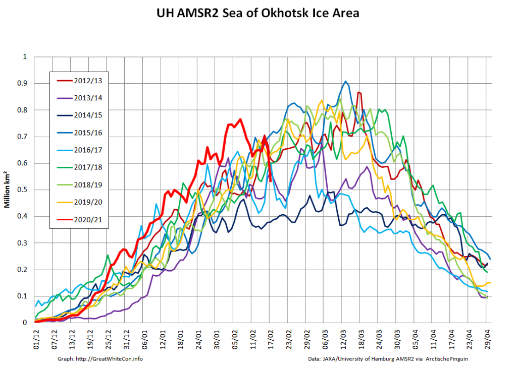
It therefore seems likely that there is more freezing still to come this year. However lets take a look at the high resolution AMSR2 sea ice area graph for the Sea Of Okhotsk:

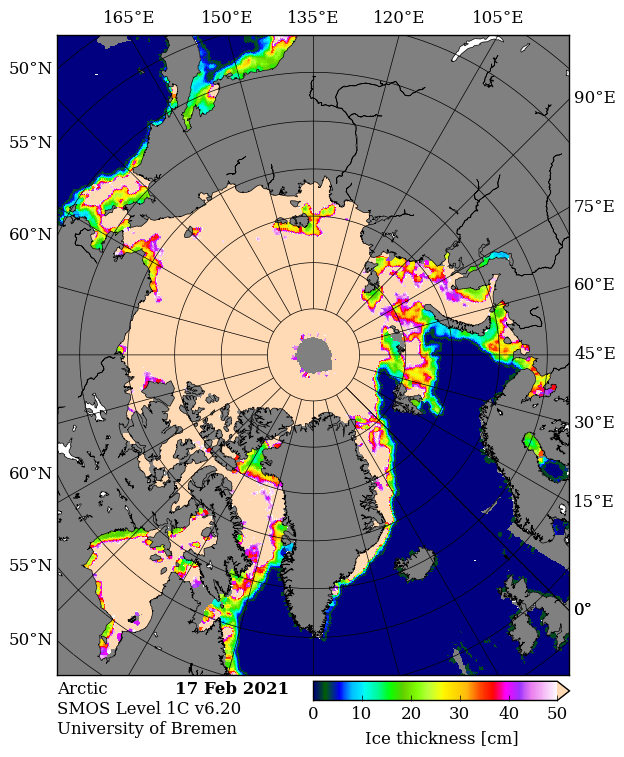
The recent fall in Arctic wide extent has evidently been driven by the recent rapid decline in this peripheral sea, where SMOS reveals more thin ice ripe for further melting:

In conclusion, the high res AMSR2 extent metric shows the tentative 2021 peak below that of 2015!

Continue reading The 2021 Maximum Arctic Sea Ice Extent

Facts About the Arctic in November 2020

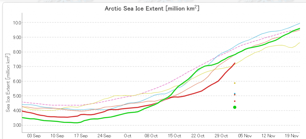
Arctic sea ice volume is of course far more important in the grand scheme of things. However sea extent is easier to measure, and the JAXA AMSR2 flavour thereof has now nudged into second place for the date above 2016:

[Edit – November 4th]

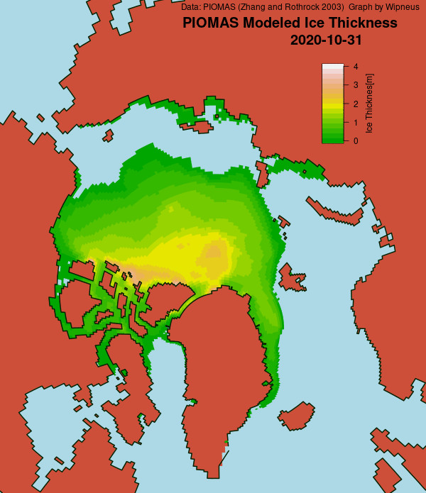
The PIOMAS gridded thickness numbers have been released, to reveal this end of October thickness map:

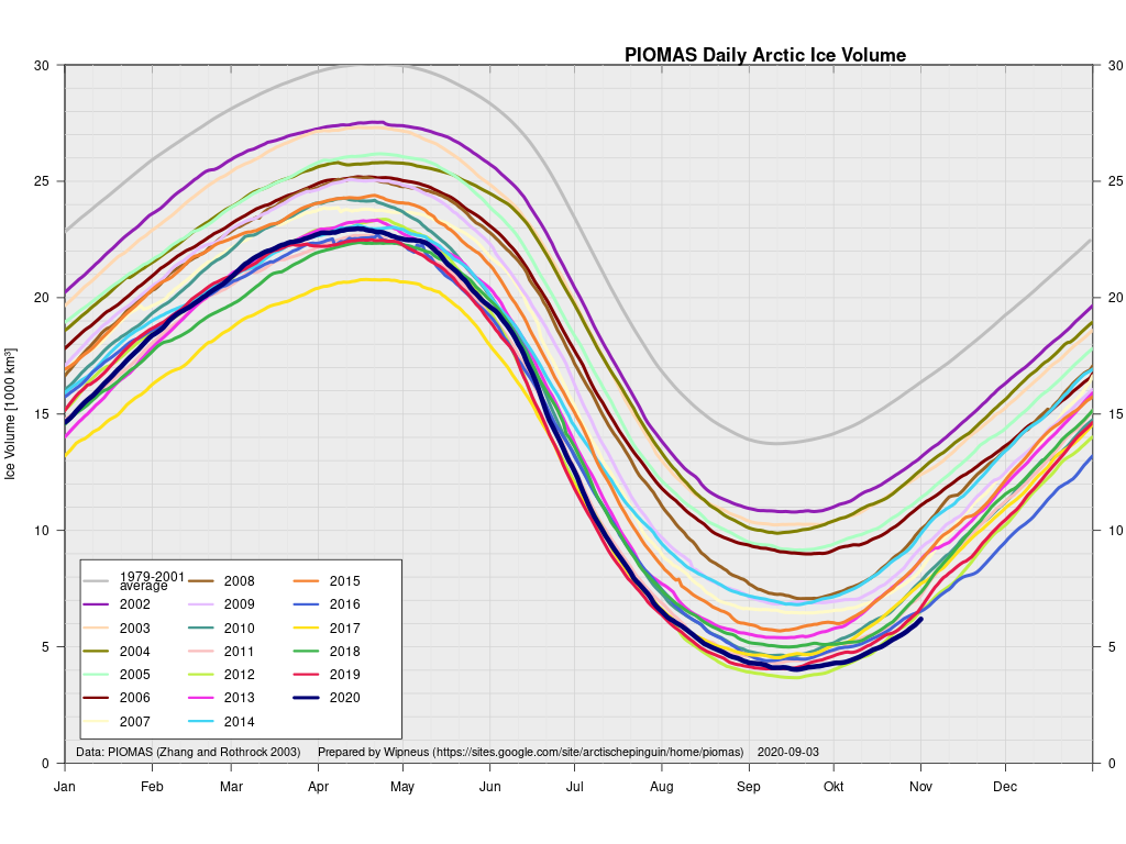
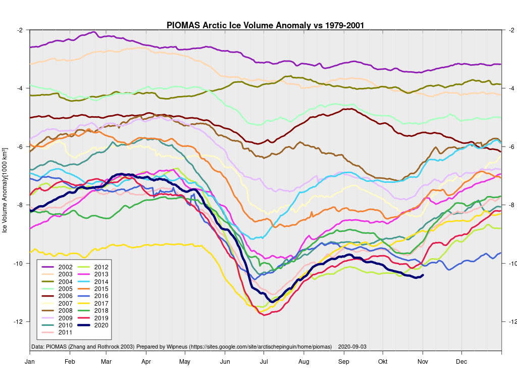
and these calculated volume graphs:

These show Arctic sea ice volume to be lowest for the date, even if extent has slipped into 2nd place.

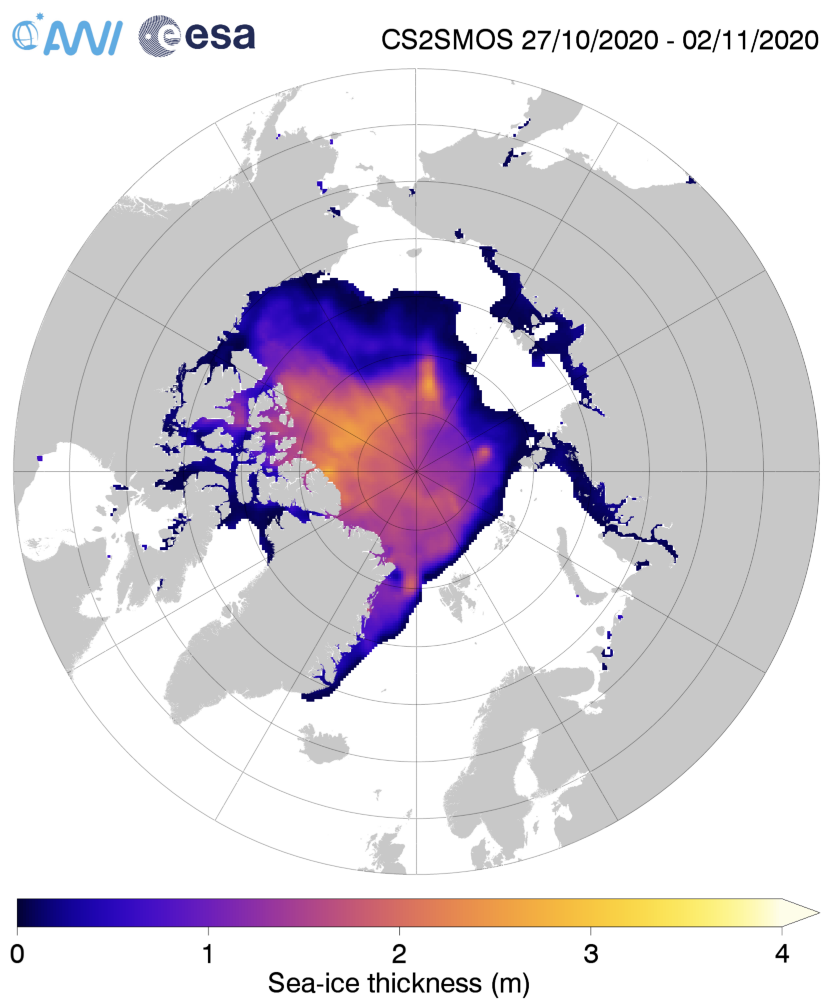
For comparison purposes here too is the latest AWI CryoSat-2/SMOS merged thickness map:

Continue reading Facts About the Arctic in November 2020

The 2020 Arctic Sea Ice Minimum Extent

I’ve been waiting for the results of the ARCUS SIPN August call, but despite the timetable specifying “26 August 2020 (Wednesday)” they’ve still not been published and I can wait no longer!

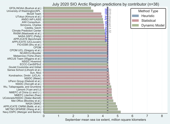
Hopefully the August “predictions” will be available soon, but for the moment let’s take a look at the July 2020 Sea Ice Outlook instead:

For the Arctic, the median July Outlook for September 2020 average sea-ice extent is 4.36 million square kilometers, essentially identical to the median prediction in the June report, with quartiles of 4.1 and 4.6 million square kilometers. For comparison, the historical record September low over the period of satellite observations was set in 2012 at 3.57 million square kilometers, and the second lowest record was 4.27 million square kilometers set in 2007. This year’s projection is close to the 2019 observed September sea-ice extent of 4.32 million square kilometers. As was also the case for the June report, only two of the outlooks project September sea-ice extent below the 2012 record. The consensus judgement against a new record low September sea-ice extent hence remains unchanged. Interestingly, as of this report, observed extent stands at a record low for this time of year.

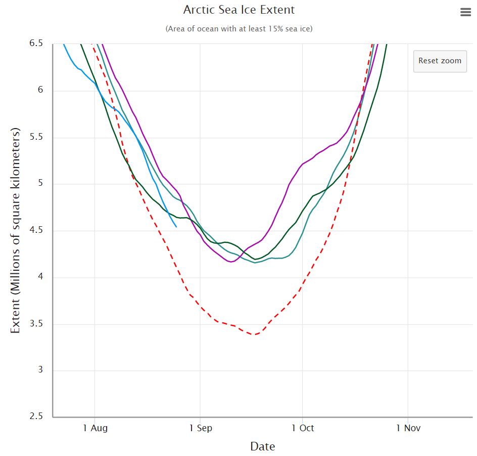
Note that those numbers represent “September 2020 average sea-ice extent” and not the daily minimum. Let’s now take a look at the assorted different flavours of “Arctic sea ice extent” metric. Firstly here’s the NSIDC’s “Charctic” 5 day average extent:

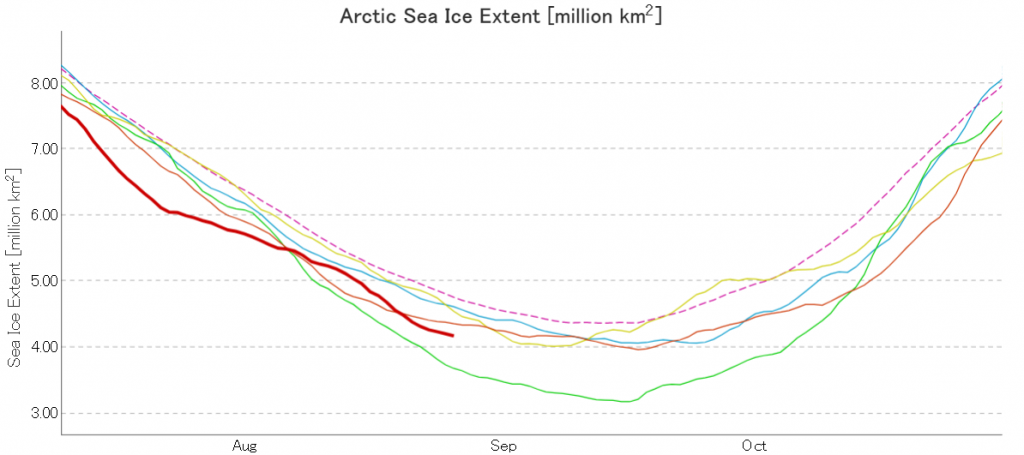
Next here’s JAXA/ViSHOP extent, generally assumed to be a “2 day average”:

Next here’s the DMI version, which neglects to include 2012:

Continue reading The 2020 Arctic Sea Ice Minimum Extent

Past Evidence Supports Complete Loss of Arctic Sea-ice by 2035

Our title today is shamelessly plagiarised from the “Watts Up With That” blog of our old friend Anthony Watts. However daring to be different we have redacted the initial word “Claim -“.

The WUWT blog post is bylined “Charles Rotter”, and refers to a new paper in the journal Nature Climate Change entitled “Sea-ice-free Arctic during the Last Interglacial supports fast future loss“. Here’s an extract from the abstract:

The Last Interglacial (LIG), a warmer period 130,000–116,000 years before present, is a potential analogue for future climate change. Stronger LIG summertime insolation at high northern latitudes drove Arctic land summer temperatures 4–5 °C higher than in the pre-industrial era. Climate model simulations have previously failed to capture these elevated temperatures, possibly because they were unable to correctly capture LIG sea-ice changes. Here, we show that the latest version of the fully coupled UK Hadley Center climate model (HadGEM3) simulates a more accurate Arctic LIG climate, including elevated temperatures. Improved model physics, including a sophisticated sea-ice melt-pond scheme, result in a complete simulated loss of Arctic sea ice in summer during the LIG, which has yet to be simulated in past generations of models. This ice-free Arctic yields a compelling solution to the long-standing puzzle of what drove LIG Arctic warmth and supports a fast retreat of future Arctic summer sea ice.

There’s no mention of “2035” in there, so let’s look instead at yesterday’s press release from the British Antarctic Survey:

Continue reading Past Evidence Supports Complete Loss of Arctic Sea-ice by 2035

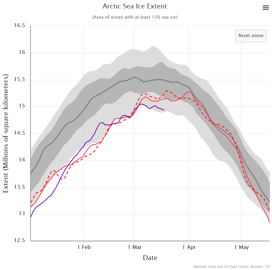
The 2020 Maximum Arctic Sea Ice Extent

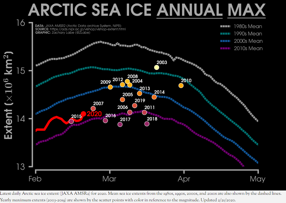
As Zack Labe has recently pointed out, in 2015 the Arctic sea ice maximum extent based on the JAXA numbers had already occurred on February 15th:

Perhaps it’s time we started paying attention this year! However the National Snow and Ice Data Center reported a significantly later date in 2015:

On February 25, 2015, Arctic sea ice extent appeared to have reached its annual maximum extent, marking the beginning of the sea ice melt season. This year’s maximum extent not only occurred early; it is also the lowest in the satellite record. However, a late season surge in ice growth is still possible.

Each year we keep track of the assorted Arctic sea ice metrics over the next month or so, and they rarely agree on the date of maximum extent, and never agree on the sea ice extent on that date! The reason for that is explained in a 2017 paper entitled “Variability and trends in the Arctic Sea ice cover: Results from different techniques“:

Reports on the sea ice cover have been provided by different institutions using basically the same set of satellite data but different techniques for estimating key parameters such as ice concentration, ice extent, and ice area. In this study, a comparison of results from four different techniques that are frequently used shows significant disagreements in the characterization of the distribution of the sea ice cover primarily in areas that have a large fraction of new ice cover or significant amount of surface melt.

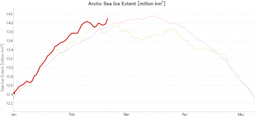
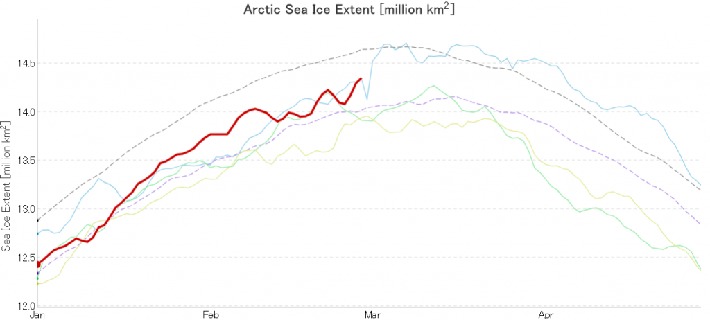
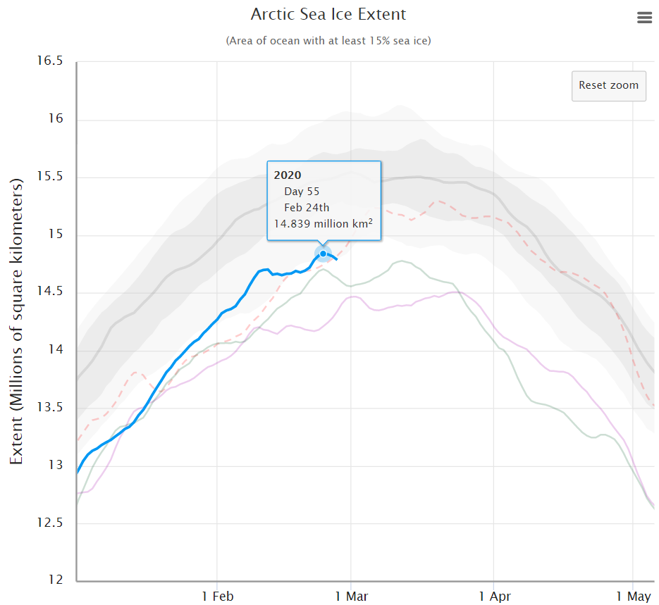
In due course we’ll look at the metrics from a variety of different institutions, but let’s start with JAXA, comparing 2020 with 2015 and the 2010s average:

Extent is clearly increasing just at the moment! Will the next peak prove to be the maximum for the year or will we have to wait another month or more to find out that value, as suggested by the average?

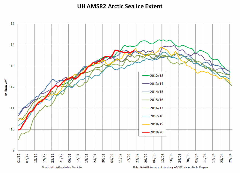
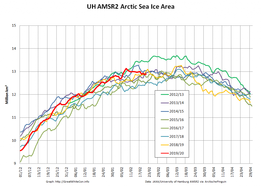
Compare and contrast JAXA extent with Wipneus’ high resolution AMSR2 extent and area:

Perhaps the 2020 maximum area has already been reached?

[Edit – February 25th]

Or perhaps not! We’re playing mix and match this morning, since Wipneus’s new numbers haven’t been released yet. Here UH AMSR2 high resolution Arctic sea ice area from February 23rd:

Plus JAXA extent for the 24th:

[Edit – February 27th]

Tony Heller’s latest sea ice themed article claims “Normal Sea Ice Extent At Both Poles”. Hence today’s JAXA extent graph includes the averages for previous decades:

Extent is evidently increasing once again, and is even more evidently well below what passed for “normal” in the twentieth century!

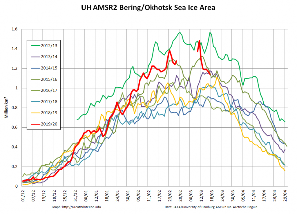
Let’s also compare the Pacific periphery:

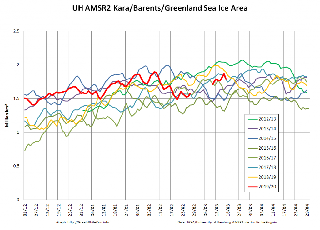
with the Atlantic side of the Arctic Ocean:

The Bering and Okhotsk Seas will be sea ice free by the time September 2020 arrives. How about the Kara, Barents and particularly Greenland Seas though?

[Edit – February 29th]

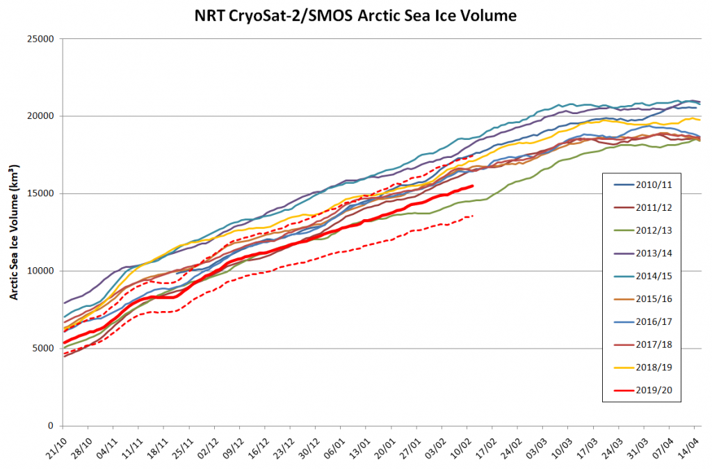
Arctic sea ice maximum volume usually occurs in April, but nonetheless let’s keep an eye on the metric that most nearly measure the “amount” of sea ice left in the Arctic in 2020. Here’s our “measured” CryoSat-2/SMOS volume metric, using reanalysed data up to February 12th:

PIOMAS “modelled” volume for February should be released soon, but getting back to extent the JAXA flavour has been setting new highs over recent days:

whereas the NSIDC’s Charctic 5 day averaged extent has not!

[Edit – March 6th]

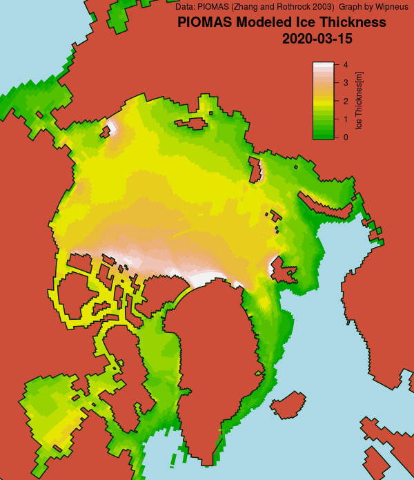
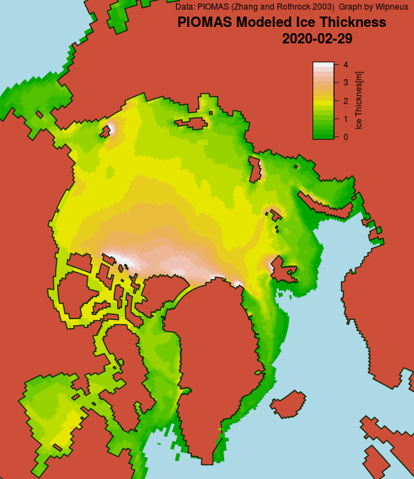
Here’s the February PIOMAS gridded Arctic sea ice thickness map, courtesy of Wipneus on the Arctic Sea Ice Forum:

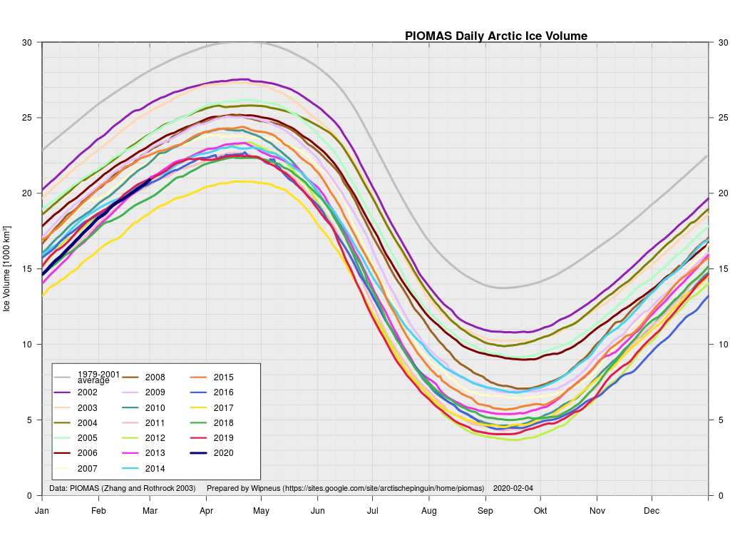
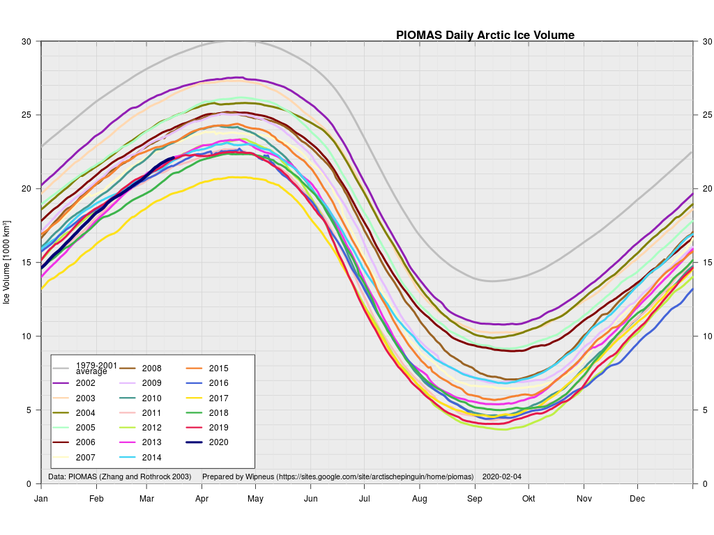
plus the traditional modelled volume graph:

As angech has pointed out elsewhere, according to the PIOMAS team:

CryoSat-2 data show total volume for February 2020 substantially lower than PIOMAS with 2020 Febuary near record low levels over the 2011-2020 period

[Edit – March 19th]

The March mid month PIOMAS numbers have been crunched by Wipneus. Here’s how things look at the moment:

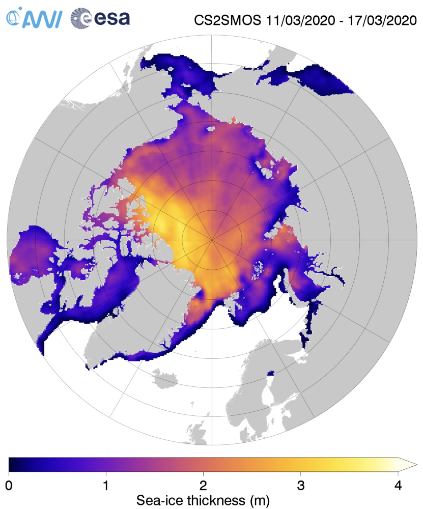
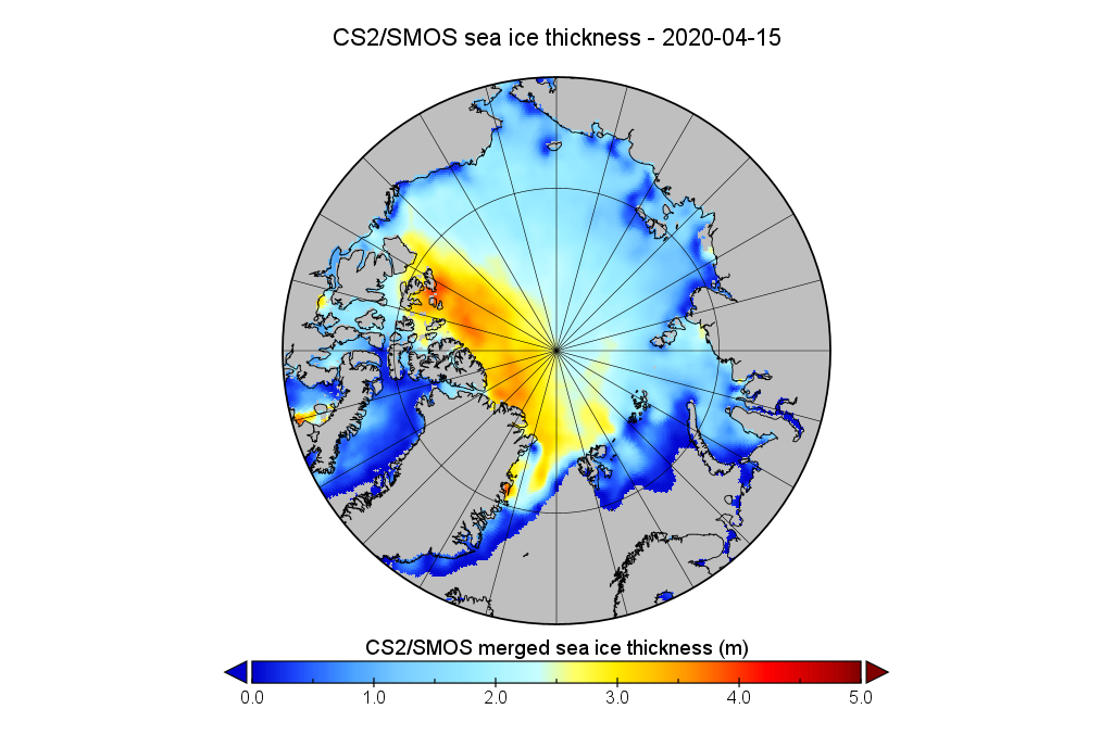
For comparison purposes here’s the current CryoSat-2/SMOS Arctic sea ice thickness map:

[Edit – March 20th]

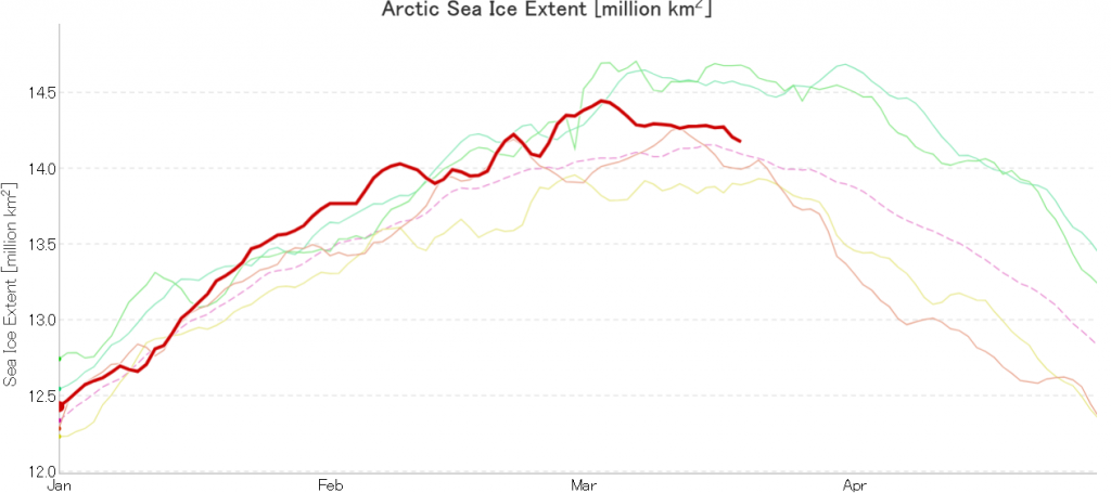
After flatlining for a long time JAXA extent has posted significant declines for two days running. There’s been no official announcement from the NSIDC as yet, but it now seems safe to conclude that there won’t be a late surge in extent similar to 2010. Here’s the current JAXA graph:

plus NSIDC’s 5 day averaged extent:

Hence the (still provisional!) maximum numbers for 2020 are:

JAXA/VISHOP AMSR2 – 14.45 million square kilometres on March 3rd
NSIDC 5 day SSMIS – 15.05 million square kilometres on March 5th

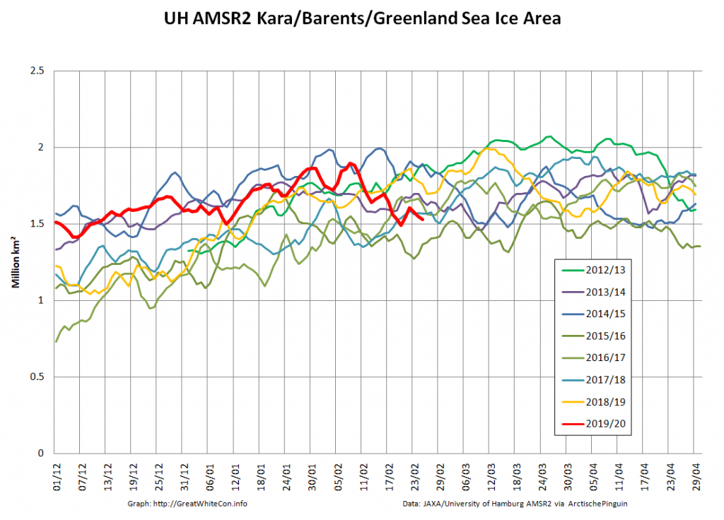
The University of Hamburg’s JAXA AMSR2 concentration data seems to have suffered an outage over the crucial period. Hopefully the gaps will be filled in due course. However more recent regional graphs  reveal the following:

The recent declines in overall extent are evidently driven by declines on the Pacific periphery.

The 2019 Arctic Sea Ice Metric Minima

September is here once again, so the assorted minima of a variety of Arctic sea ice metrics will be reached soon, if they haven’t happened already!

In the latter category let’s first take a look at the NSIDC’s 5 day averaged SSMIS based Arctic sea ice extent:
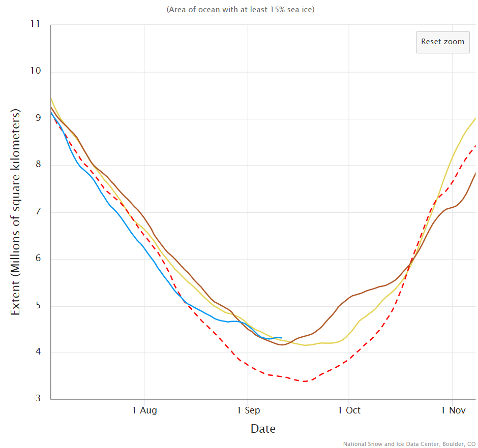
It looks entirely feasible that the current minimum of  4.29 million square kilometres on September 7th will hold for the rest of the calendar year. The daily NSIDC number is currently 4.24 million km² on September 4th.

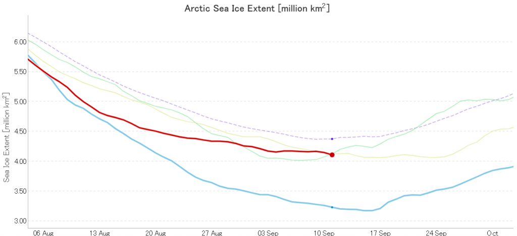
By way of contrast the JAXA/ViSHOP AMSR2 based extent hit a new low of  4.11 million  km² yesterday:
And what of our much beloved high resolution AMSR2 metrics derived by “Wipneus” from the University of Hamburg’s AMSR2 concentration data? Area certainly looks to be past the minimum for this year, whereas extent is still conceivably capable of another push lower:
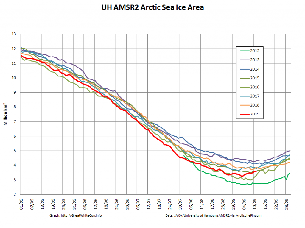
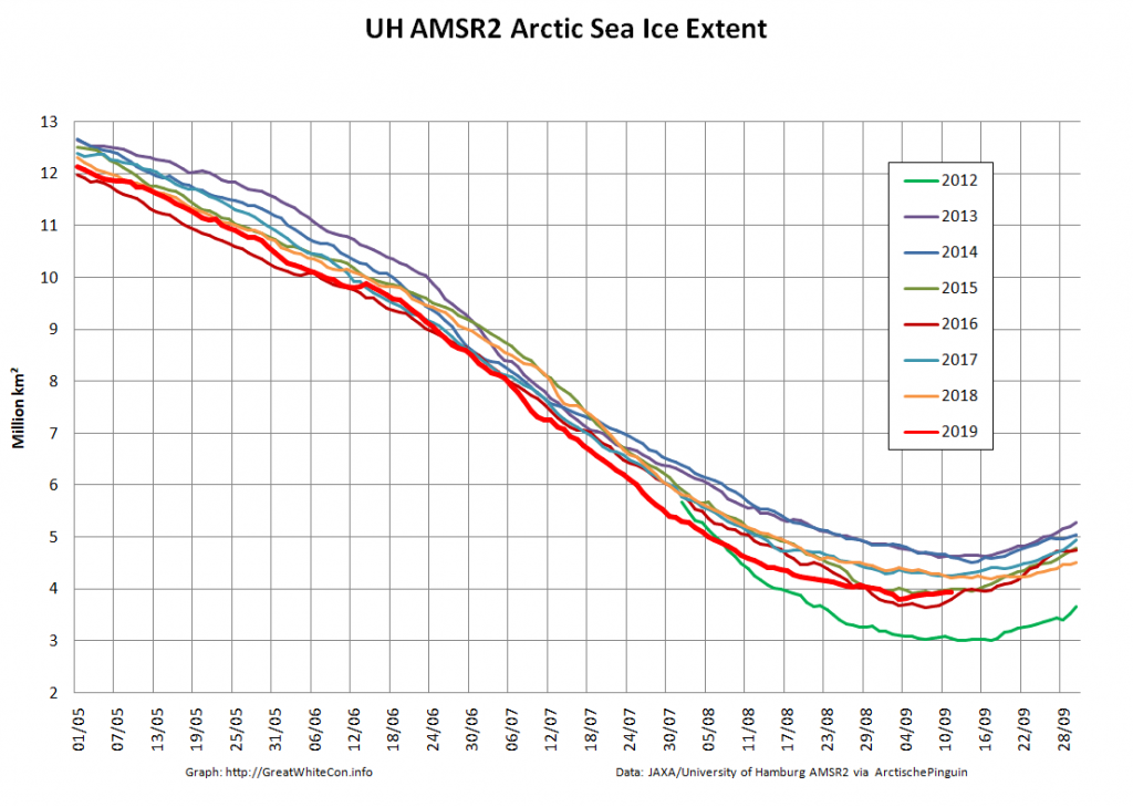
The provisional minimum extent for 2019 is 3.80 million km² on September 3rd.

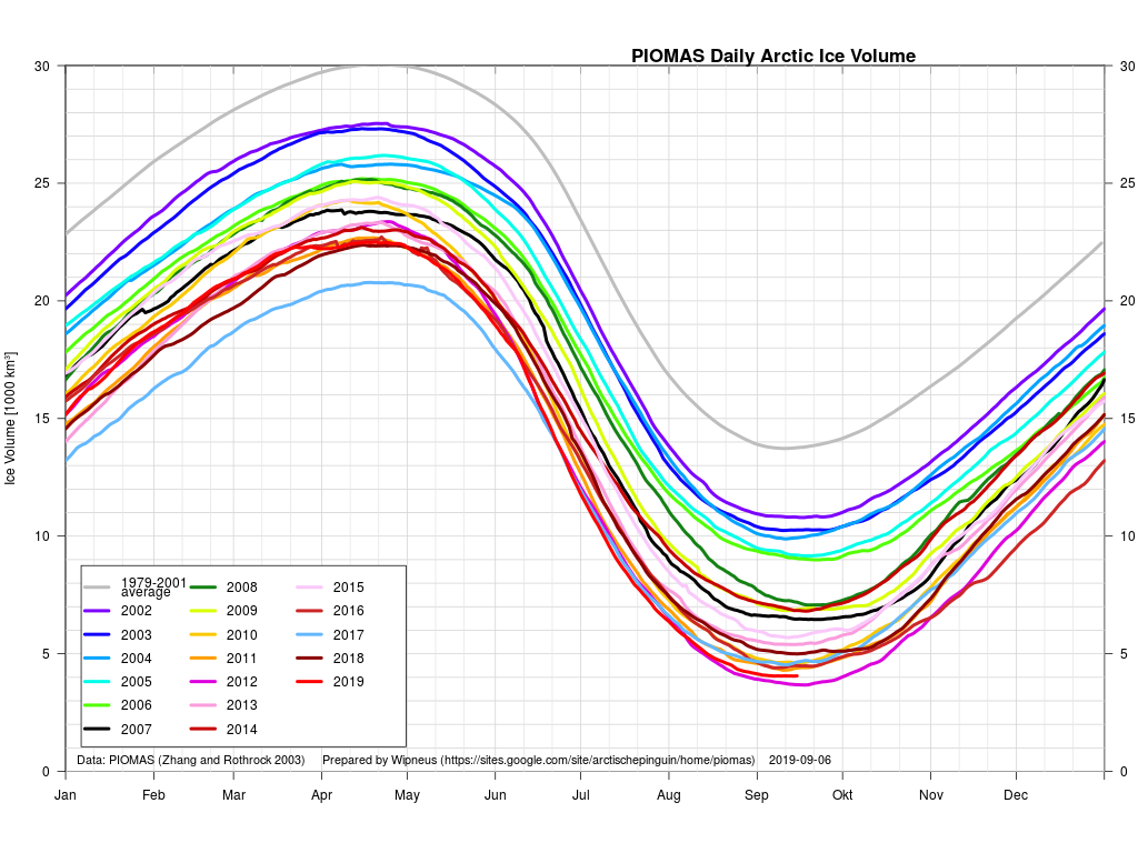
The minimum Arctic sea ice volume generally occurs slightly later than area or extent. The data certainly arrives later! Here’s the PIOMAS graph up to August 31st:

and here’s the associated thickness map:
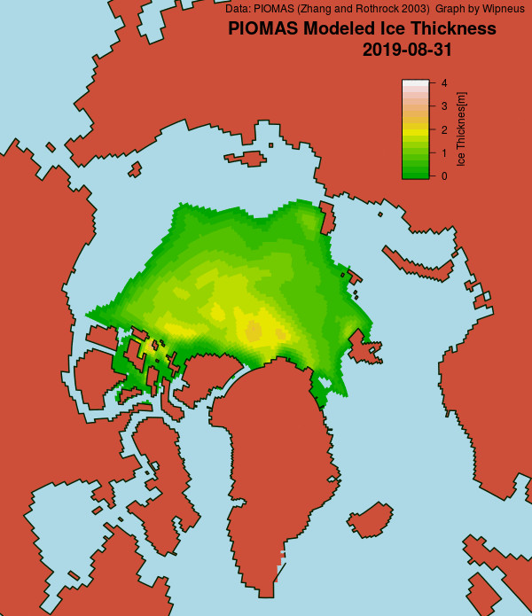
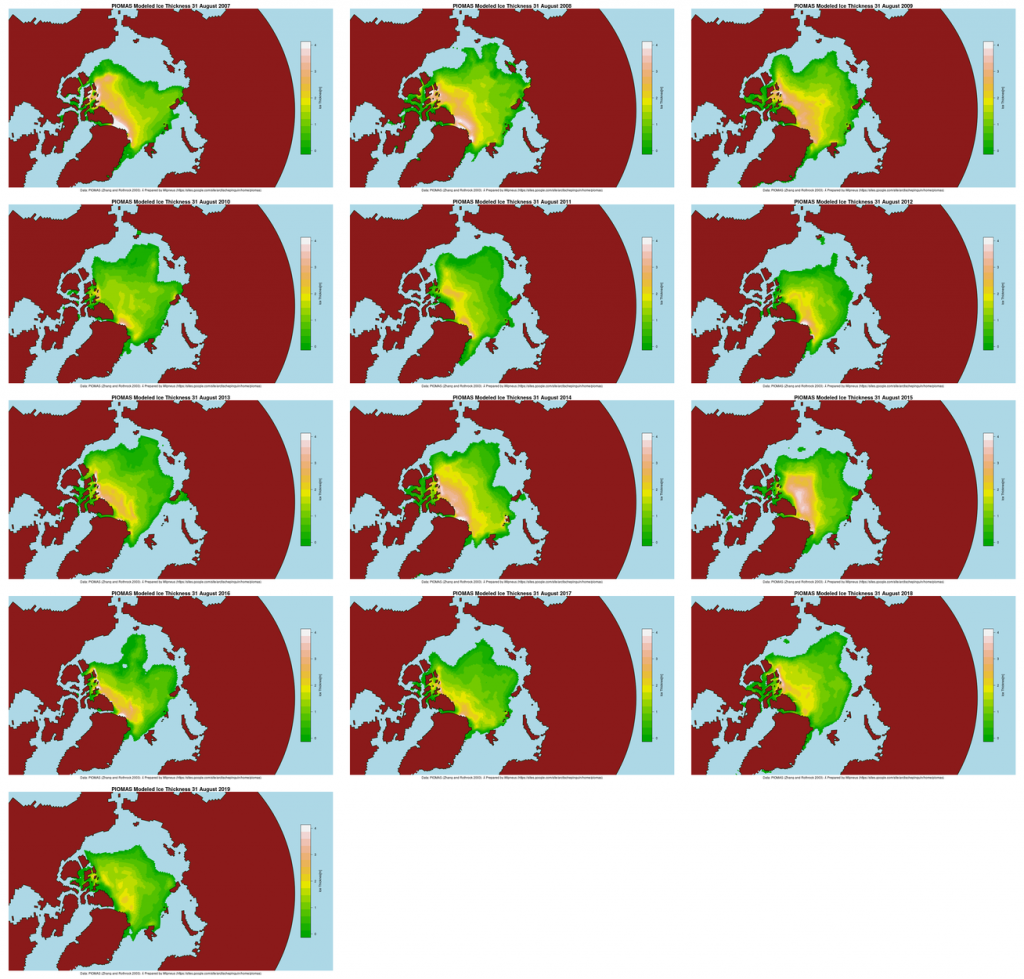
Note that Arctic wide modelled volume is only slightly higher than in 2012 at the same time of year, but there is a noticeably greater percentage gap in extent. That implies that average ice thickness across the Arctic is lower in 2019 than in 2012.

Note also that the thickest ice is no longer located along the north coasts of Greenland and the Canadian Arctic Archipelago. Here are the equivalent maps for previous years for comparison purposes:
Perhaps JAXA extent will head still lower over the next few days? Perhaps PIOMAS volume will sneak below 2012 before the peripheral refreeze begins?

[Edit – September 13th]

JAXA Arctic sea ice extent has reached a new minimum of 4.09 million km².

NSIDC daily extent is currently 4.28 million km², still just above the September 4th minimum.

[Edit – September 14th]

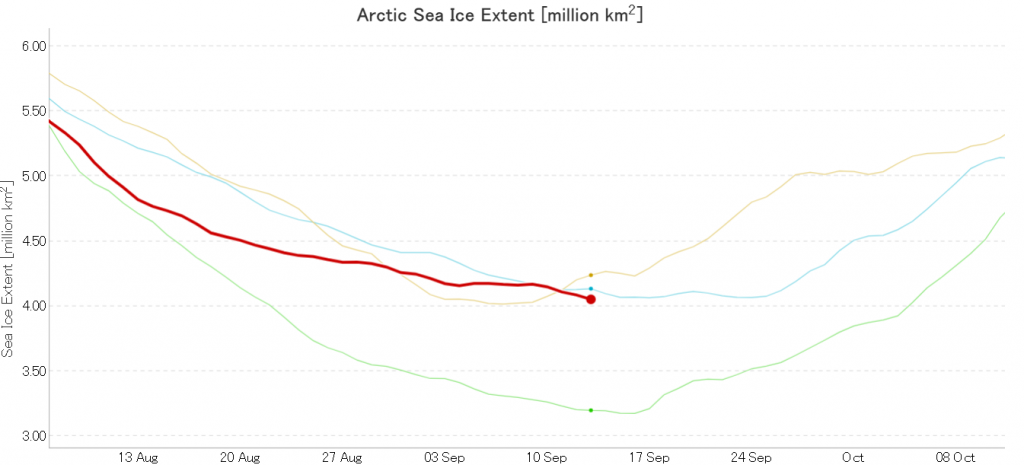
JAXA Arctic sea ice extent has reached a new minimum of 4.05 million km², which now puts it below the 2007 minimum that occurred somewhat later in September:
[Edit – September 14th PM]

NSIDC 5 day averaged extent has also (by a whisker!) reached a new minimum for the year of 4.285 million km²:
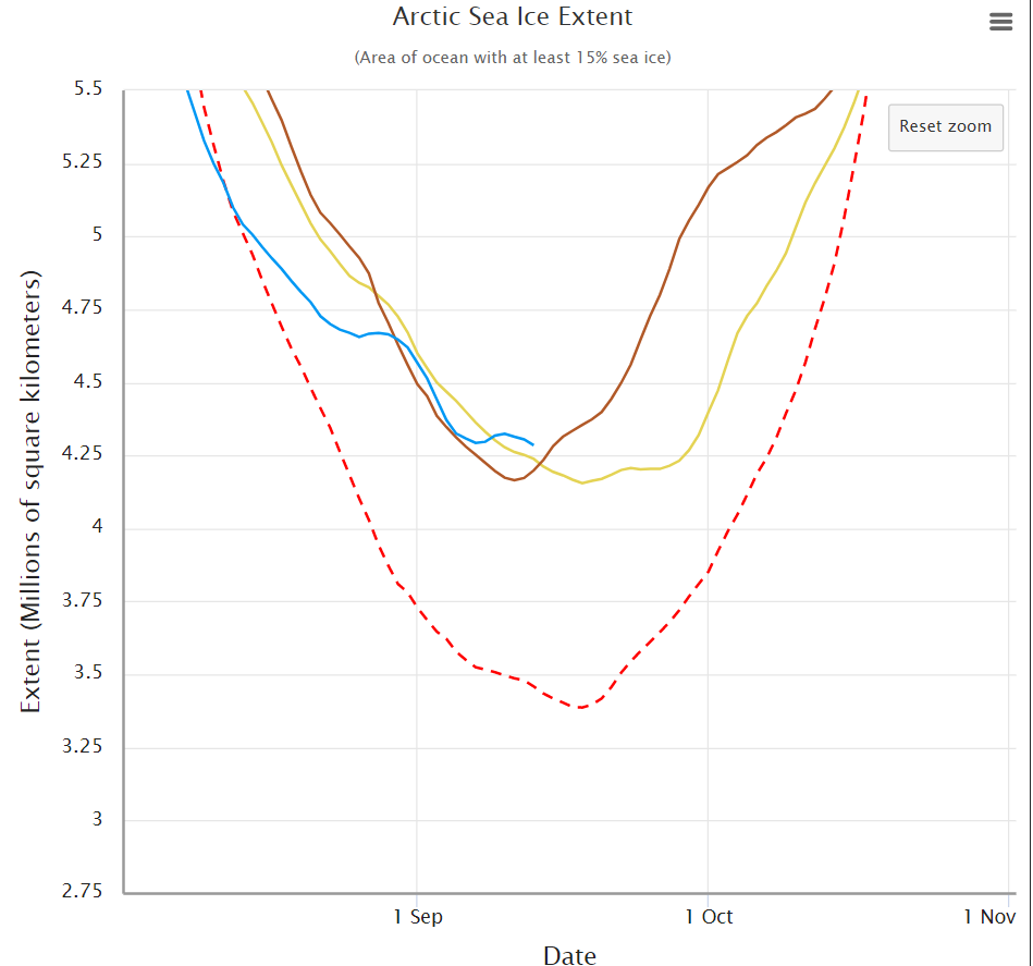
The daily number fell to 4.21 million km².

[Edit – September 15th]

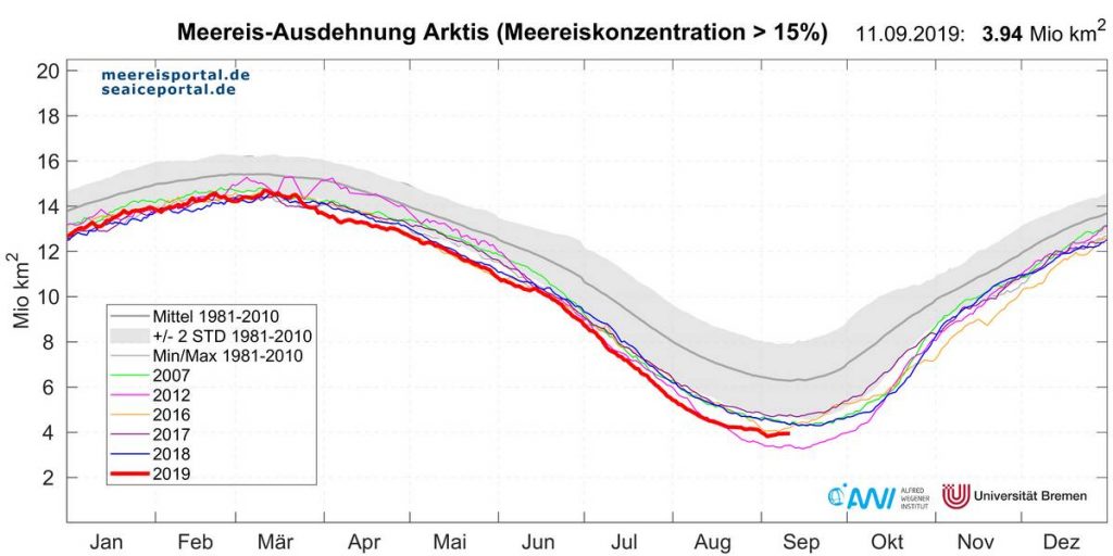
I have somewhat belatedly discovered that in the build up to the forthcoming MOSAiC Expedition the Alfred Wegener Institute recently announced  that:

The sea-ice extent in the Arctic is nearing its annual minimum at the end of the melt season in September. Only circa 3.9 million square kilometres of the Arctic Ocean are covered by sea ice any more, according to researchers from the Alfred Wegener Institute and the University of Bremen. This is only the second time that the annual minimum has dropped below four million square kilometres since satellite measurements began in 1979.
[Edit – September 16th]

JAXA/ViSHOP extent has dropped below the 2016 minimum, and now measures 4.01 million km²:
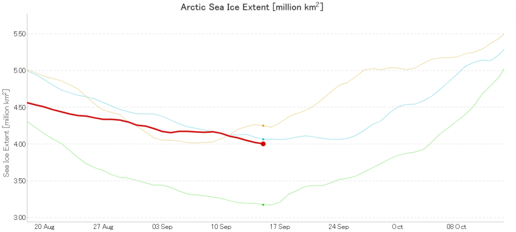
Only 2012 left to beat!

Wipneus’ high resolution AMSR2 extent has also posted a new low for the year, but still has a little way to go before passing 2016:
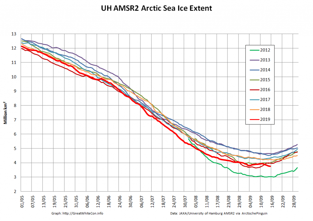
Area is also currently declining, but is still well away from a new minimum for 2019:
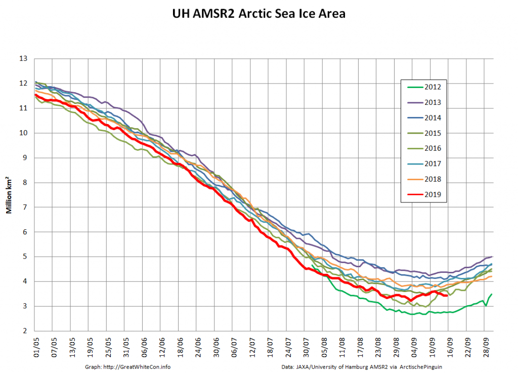
[Edit – September 19th]

After some more modest declines JAXA/ViSHOP extent has just increased marginally from the previous day, and now measures 3.98 million km²:
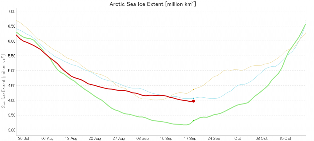
That puts the (very!) tentative minimum for 2019 at 3.96 million km² on September 17th.

[Edit – September 20th]

The mid month PIOMAS gridded thickness and volume numbers have been released:
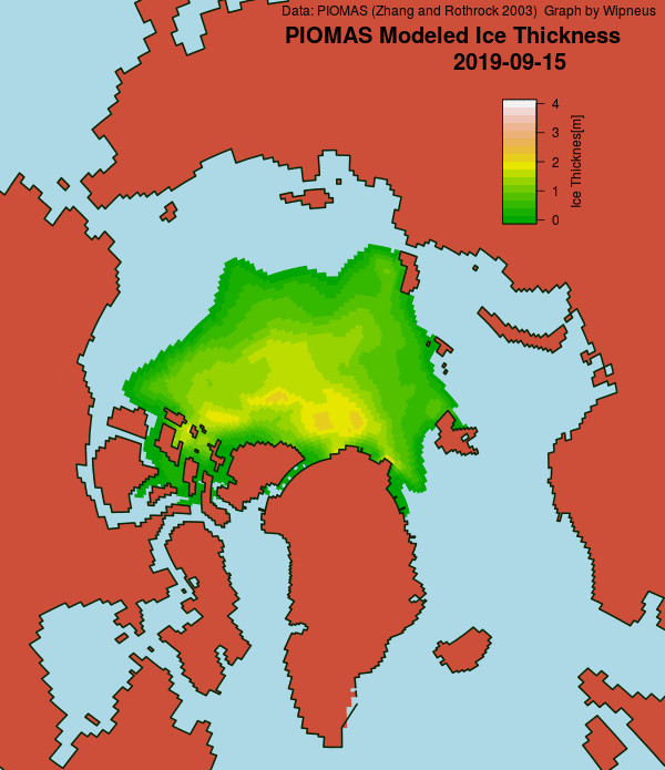
As anticipated given recent extent values, the volume difference from 2012 has increased somewhat over the last two weeks.

[Edit – September 23rd]

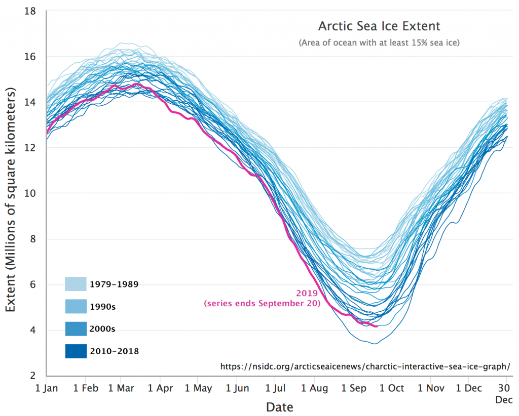
The National Snow and Ice Data Center have called the 2019 minimum in their latest edition of Arctic Sea Ice News:

On September 18, 2019, sea ice extent dropped to 4.15 million square kilometers (1.60 million square miles), effectively tied for the second lowest minimum in the satellite record along with 2007 and 2016. This appears to be the lowest extent of the year. In response to the setting sun and falling temperatures, ice extent will begin increasing through autumn and winter. However, a shift in wind patterns or a period of late season melt could still push the ice extent lower.
[Edit – September 24th]

To summarise the assorted minimum extent metrics for 2019:

University of Bremen – 3.77 million km² on September 18th, 2nd lowest behind 2012.
JAXA/ViSHOP – 3.96 million km² on September 17th, “Statistical tie” with 2016 for 2nd lowest.
NSIDC 1 day – 4.10 million km² on September 17th, “Statistical tie” with 2016 for 2nd lowest.
NSIDC 5 day – 4.15 million km² on September 18th, 2nd lowest behind 2012.

[Edit – October 1st]

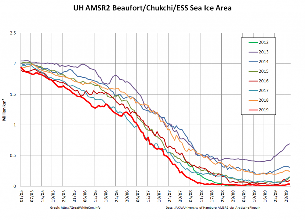
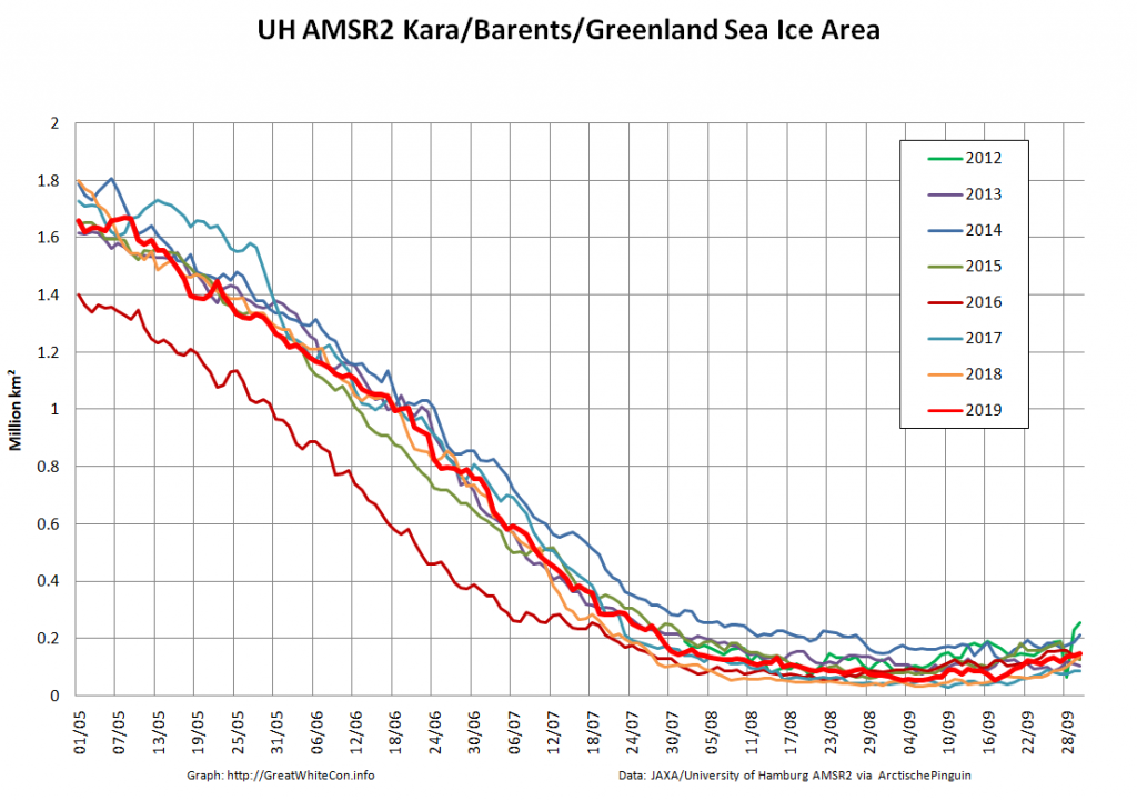
Two sides of the same coin? Sea ice area on the Pacific side of the Arctic has been at historic lows for most of the melting season:
whereas on the Atlantic side:
[Edit – October 7th]
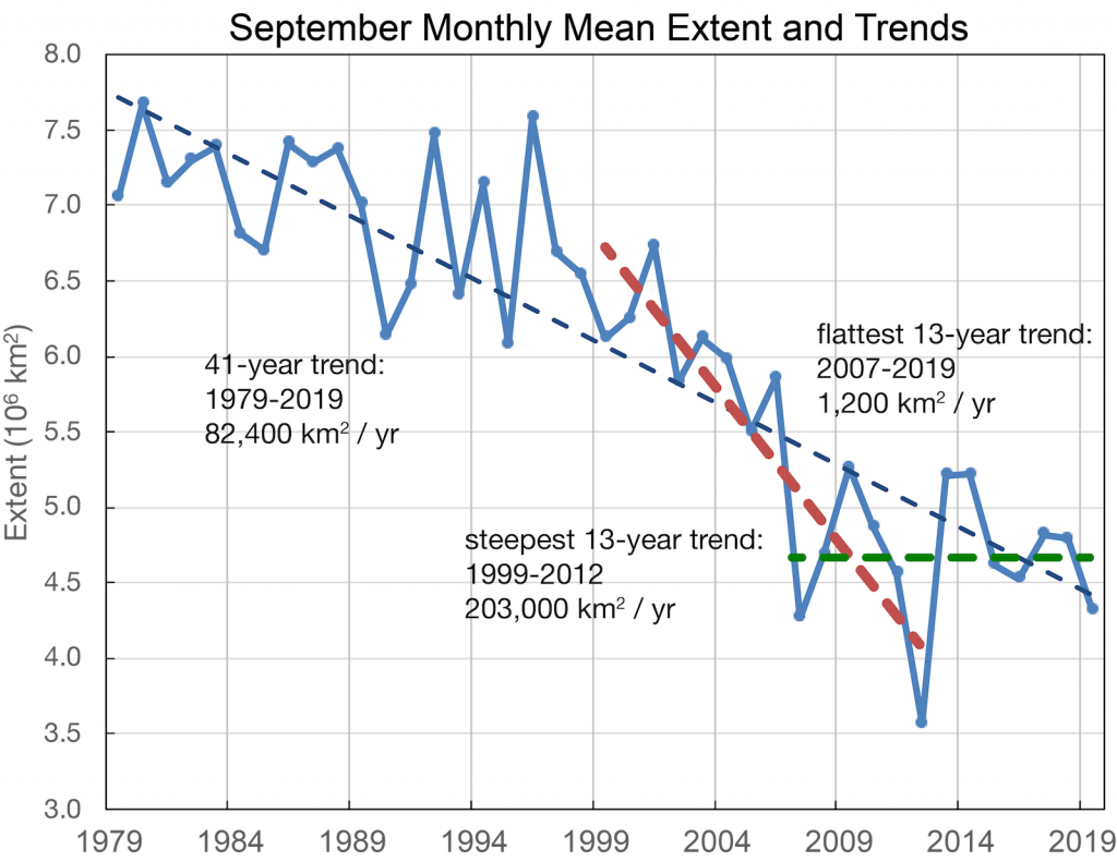
The September monthly numbers have arrived from the NSIDC, together with some intriguing annotations by Walt Meier:
Watch this space. Just in case!
Melt Pond May 2019

A couple of years ago I was asked to provide “a handful of things [you] will be keeping an eye on over the next few months to judge how ‘good’ or ‘bad’ the melt is going?”

My answer was, and remains:

5 fingers worth to start with? Not necessarily in order of time or importance!
1. How soon melt ponds and/or open water hang around in the Beaufort Sea this year. Things started very early [in 2016]:

https://GreatWhiteCon.info/2016/04/the-beaufort-gyre-goes-into-overdrive/

2. Ditto the Bering Strait and Chukchi Sea

3. Ditto the Laptev and East Siberian Seas

4. How many (and how deep, warm, wet) spring cyclones spin around the Arctic Ocean

5. How the snow melt progresses across Canada, Alaska and Siberia

Applying the same criteria this year, open water is already hanging around in the Beaufort Sea, as well as the Amundsen Gulf:

NASA Worldview “true-color” image of the Beaufort Sea on May 21st 2019, derived from the MODIS sensor on the Terra satellite

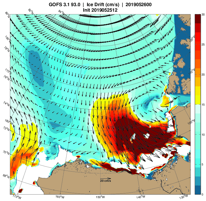
What’s more a cyclone is currently spinning in the area too:

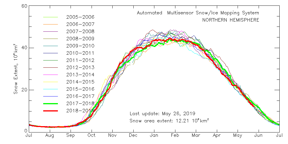
With those prerequisites in place, how about my other criteria? Here’s the current northern hemisphere snow cover graph:

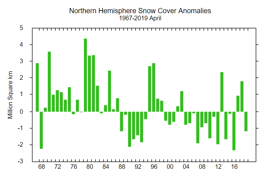
That suggests snow cover over land is close to recent lows, which is confirmed by the Rutgers University snow cover anomaly graph for April:

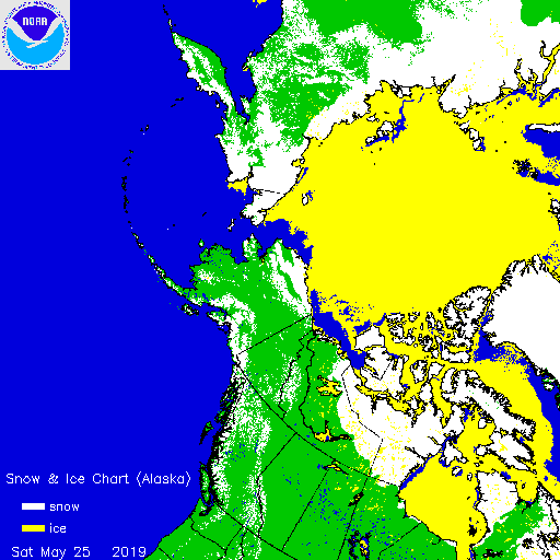
This year is anomalously low, but not by as much as 2012 and 2016. For completeness, here also is the current US National Ice Center snow cover map:

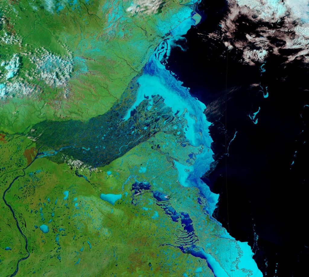
Moving on to melt ponds, there are plenty to be seen on the fast ice around the Mackenzie river delta:

NASA Worldview “false-color” image of the Mackenzie Delta on May 24th 2019, derived from the MODIS sensor on the Terra satellite

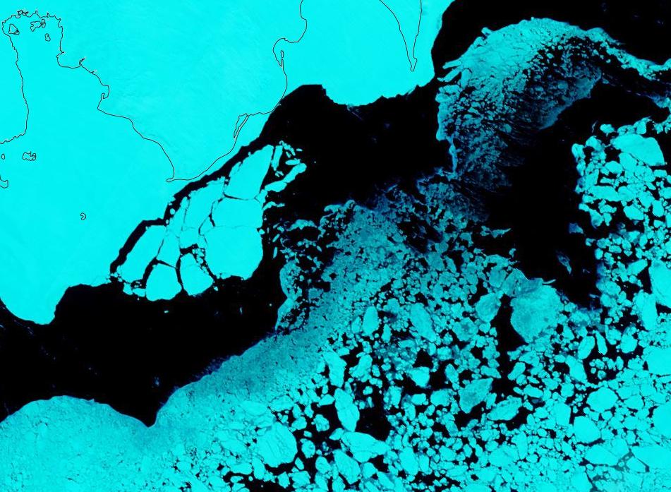
There also seem to be signs of some at a higher latitude off Ostrov Kotelny in the New Siberian Islands:

NASA Worldview “false-color” image of the Laptev Sea on May 23rd 2019, derived from the MODIS sensor on the Terra satellite

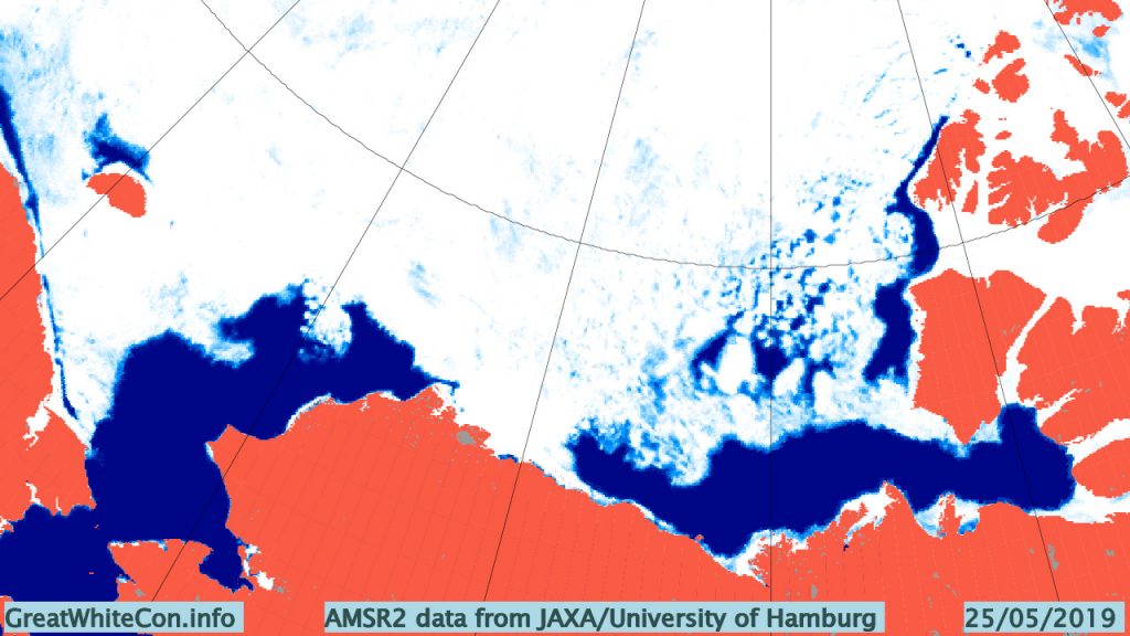
This year there is also a lot of open water in the Chukchi Sea, and almost no sea ice left in the Bering Sea:

Compared with 2016 at the same time of year I am compelled to say that with June 1st just around the corner the 2019 summer melting season is primed to progress more quickly.

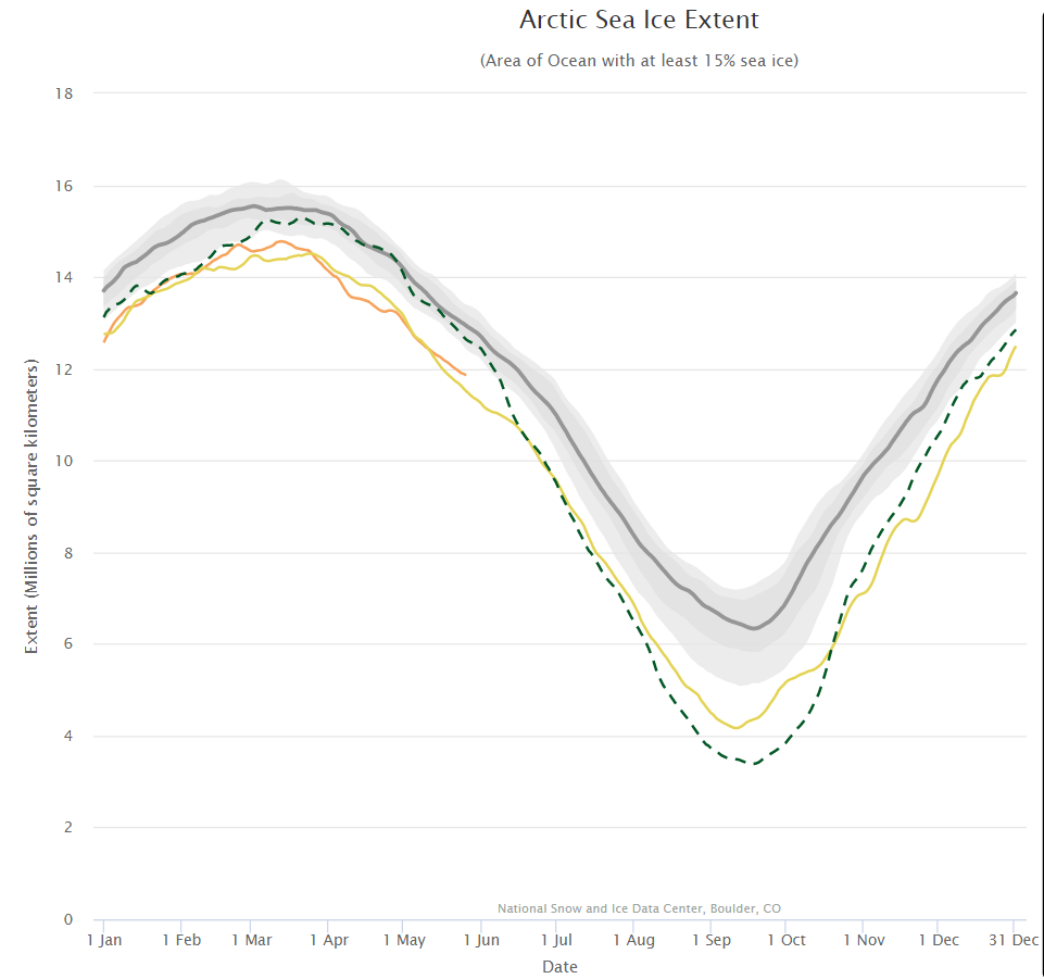
The next obvious comparison to make is with the (in)famous year of 2012, which resulted in the lowest ever minimum extent in the satellite record. Firstly let’s look at the National Snow and Ice Data Center’s graph of Arctic sea ice extent:

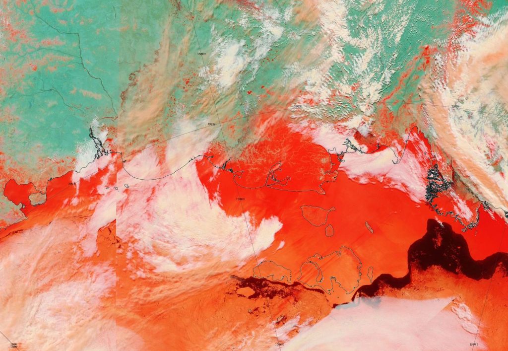
Currently extent is significantly below 2012, albeit somewhat above 2016 at the same time of year. And what of melt ponds? In 2012 there was evidence of less snow cover over land and more surface water on the ice on the Siberian side of the Arctic:

NASA Worldview “false-color” image of the Eastern Arctic on May 25th 2012, derived from the MODIS sensor on the Terra satellite

Other than that Arctic sea ice in 2019 looks to be in worse shape than in 2012.

[Edit – May 27th]

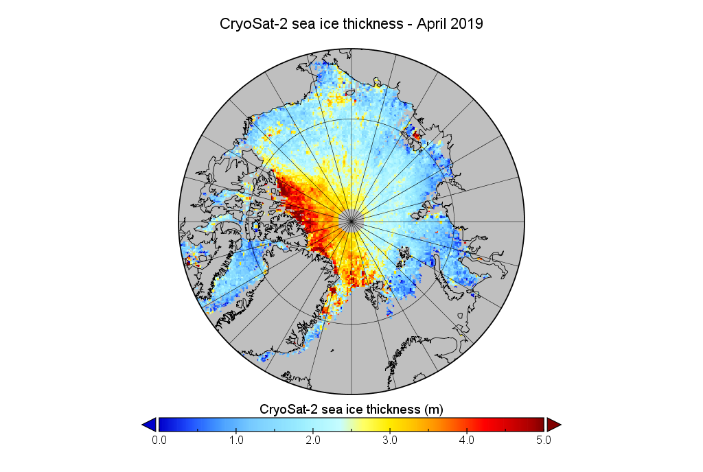
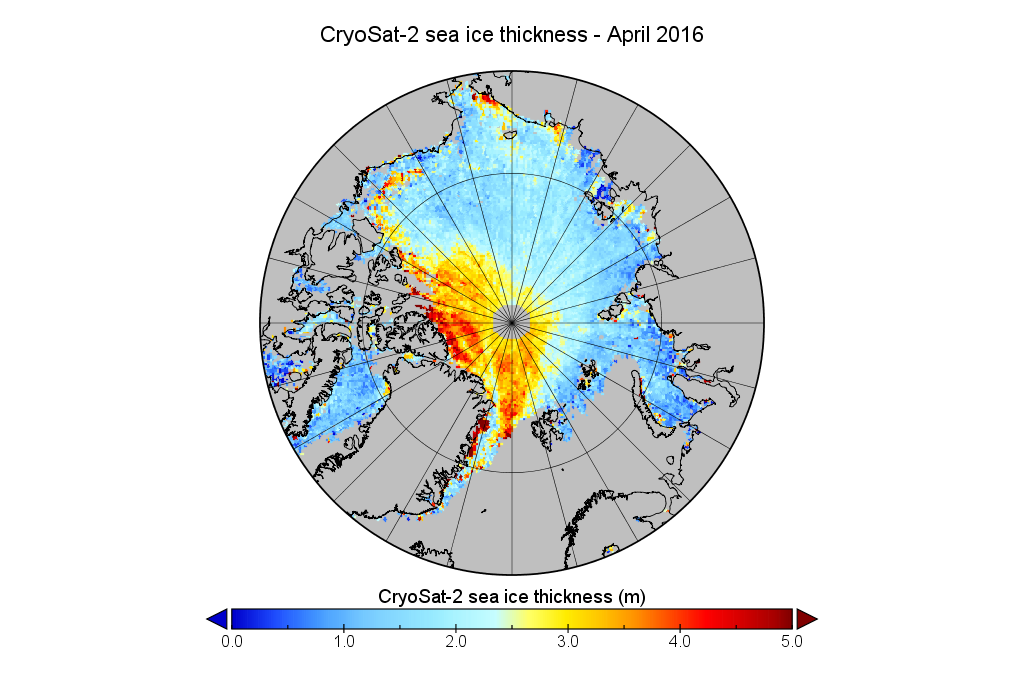
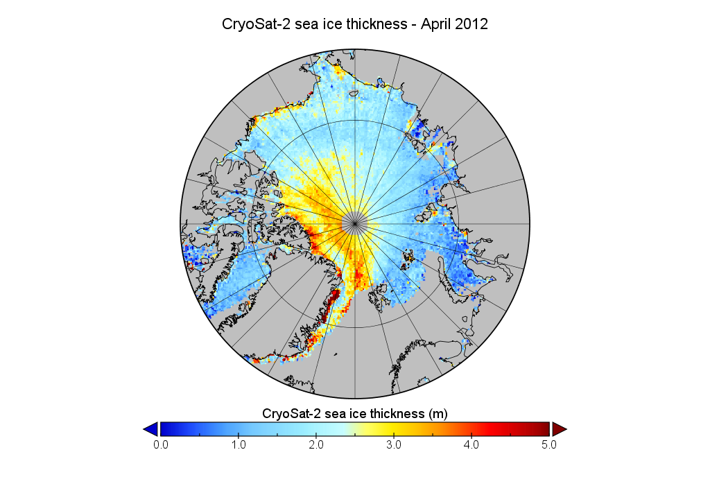
We’ve established that the extent of Arctic sea ice at the end of May 2019 is less than in 2012, but something else to consider is whether that ice is currently thicker than in 2012, or not. Satellites can have a reasonable stab at measuring the area of sea ice, but the third dimension is much trickier. The European Space Agency’s CryoSat-2 satellite has been attempting to measure sea ice thickness since 2010, so let’s take at the conclusions it has reached:

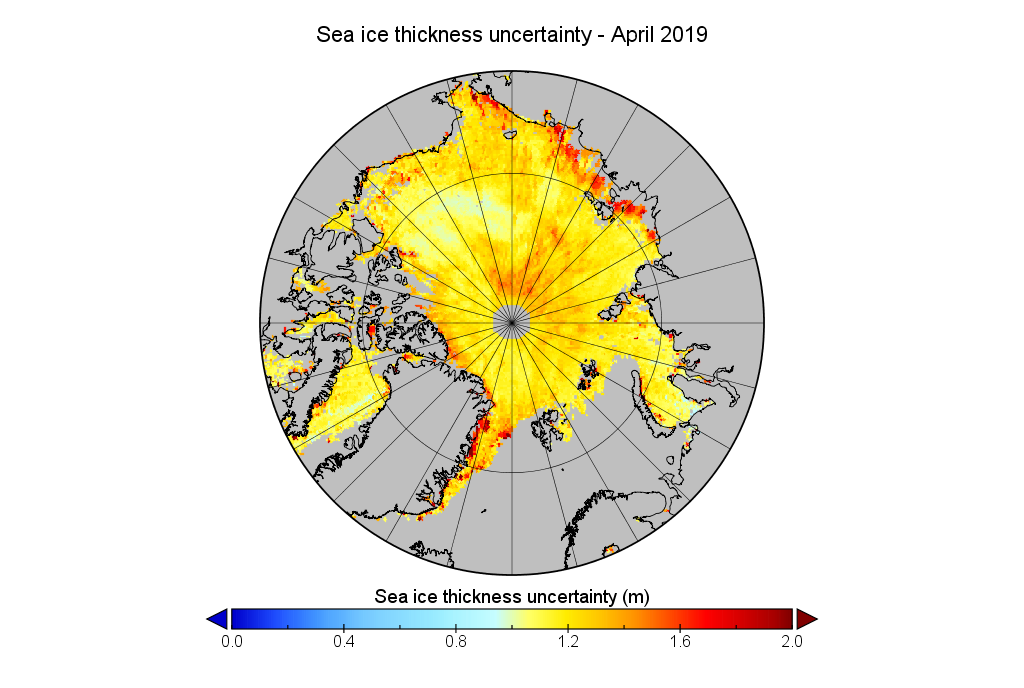
Don’t forget to take a good long look at the associated uncertainties too:

Watch this space!
Facts About the Arctic in April 2019

At the beginning of April 2019 all the assorted Arctic sea ice extent metrics are at their respective lowest levels for the date in the satellite record. Just for a change let’s start with the JAXA/ViSHOP graph for April 1st, based on AMSR2 data:

That shows extent apparently on an inexorable decline. However the higher resolution graphs derived by Wipneus from University of Hamburg AMSR2 concentration data reveal that Arctic sea ice extent has changed little over the last couple of days, and area has even increased somewhat:

Whilst we wait for Wipneus’ latest PIOMAS thickness and volume update, here’s the gridded merged CryoSat-2/SMOS thickness data from the Finnish Meteorological Institute:

Watch this space for some other extent graphs once they’ve updated to April 1st. In particular the DMI’s version of events will be of great interest, since by way of a little All Fools Day fun I passed on the latest Arctic sea ice news to Tony Heller and the denizens of his “Deplorable Climate Science Blog” yesterday. They were not amused! By way of example, Rah solemnly informed me that:

Tony consistently has used the DMI data as his primary source on the conditions in the Arctic, while you jump to whatever source you think justifies your bias. Get a life. Arctic air temps this year so far have been running below what they were at this time last year.

This is the graph that Steve/Tony used in an attempt to make his point:

Accompanied by his sage thoughts on the matter:

That has to be your lamest cherry-pick on record.

Here too is the latest graph of Rah and Tony’s beloved DMI “Arctic air temps”:

P.S. Here are the April 1st numbers from Steve/Tony’s current metric du jour:

and from the National Snow and Ice Data Center:

Plus the April 2nd DMI “Arctic temperature” graph:


[Edit – April 3rd]

Snow White asked Axel Schweiger nicely on Twitter, and as if by magic the PIOMAS numbers for March have been released, including gridded thickness. Wipneus has crunched them to reveal the following end of March sea ice thickness map:

plus a rather unusual volume graph:

Here’s a closeup view:

According to the PIOMAS model Arctic sea ice volume has been flatlining for the last couple of weeks, and may even have peaked already!

Meanwhile returning to 2 dimensions the decline in area has resumed:


[Edit – April 7th]

Wipneus’ UH high resolution extent fell another 129k yesterday:

Plus a close up look at the FMI merged Cryosat-2/SMOS thickness for both the Atlantic and Pacific sides of the Arctic:

Apart from the usual thick ice queueing for the Fram Strait exit there’s not a lot to prevent the comparatively swift early melt from continuing apace.