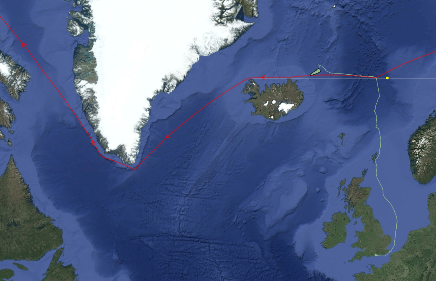
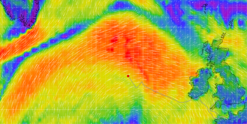
I mentioned the start of Ella Hibbert‘s long voyage in her yacht Yeva over on this year’s Northwest Passage thread. Ella and Yeva have now crossed north of the Arctic Circle near Iceland and have begun their attempt to circumnavigate the Arctic in a single summer by sailing past the north of Iceland in a westerly direction:
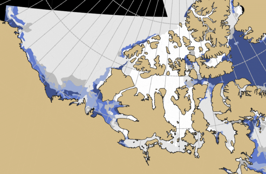
Prompted by a comment by Tom in the June open thread, the time has evidently come to open the 2023 Northwest Passage passage thread. First of all let’s get our bearings with the help of this map of the area:
and another map detailing the routes through Canadian Arctic Archipelago that have previously been successfully traversed:
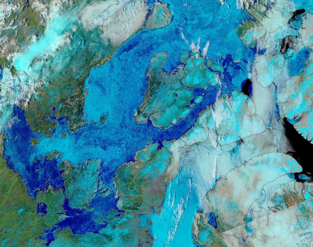
As our starter for ten for 2023, there is already plenty of open water in the Amundsen Gulf, together with plenty of melt ponding on the remaining fast ice in Franklin and Darnley Bays:
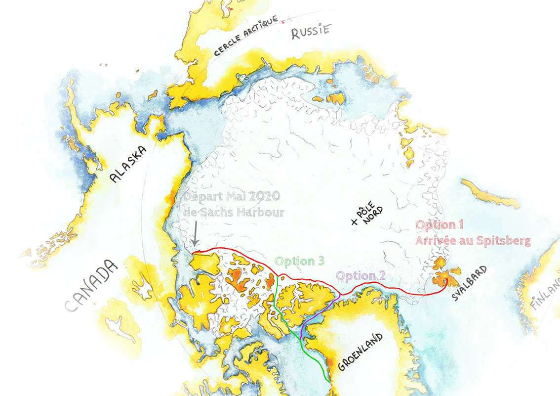
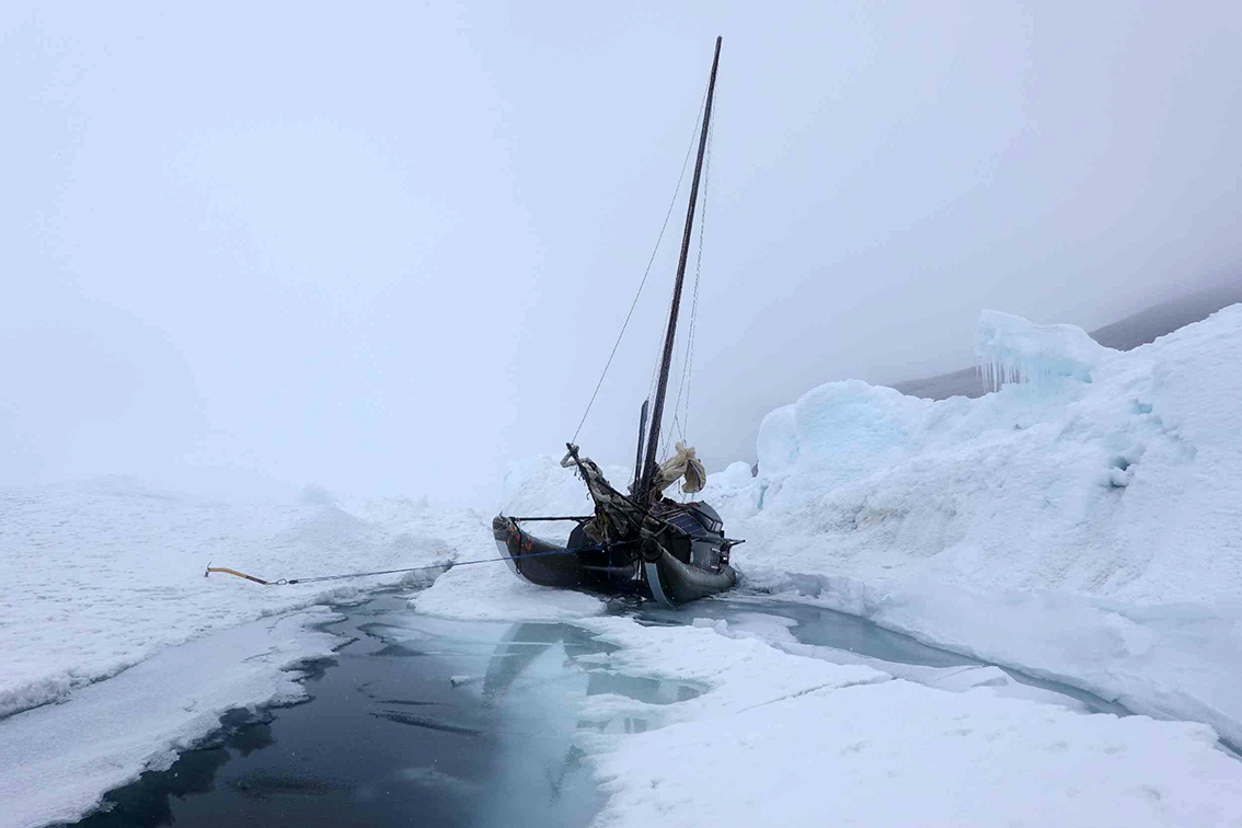
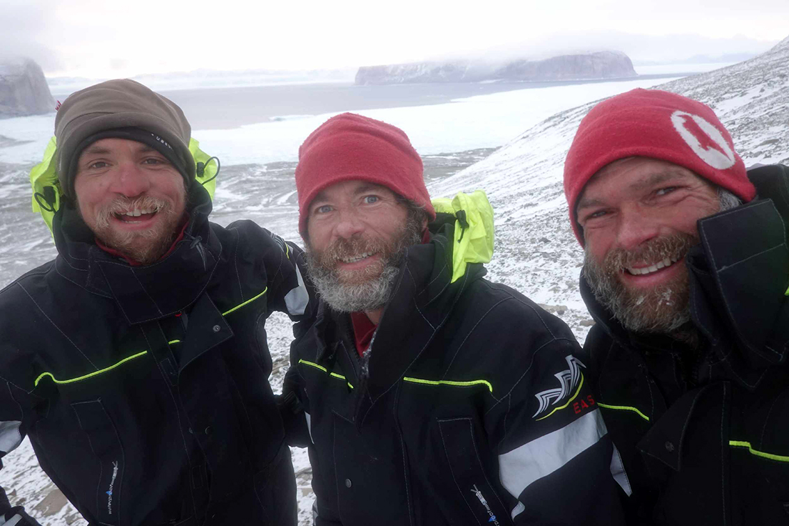
Extremely belatedly I’ve just discovered that many weeks ago Sébastien Roubinet set out on another expedition to cross the Arctic Ocean in an ice skating catamaran, now christened Babouch-ty. Seb has already led several similar expeditions in the high Arctic, and on this occasion he is accompanied by Eric André and Jimmy Hery. They set sail from Sachs Harbour on Banks Island at the end of June, and have seen many sights since then! Here are a few of them:
Here too is a more recent image of Babouch-ty and Ellesmere Island:
The Nagalaqa tracking map shows that Babouch-ty looks set to round Cape Columbia, the northernmost point on Ellesmere Island, round about now:
The original aim of the expedition was to reach Svalbard via Cap Morris Jesup, but given the length of time it has taken the team to get this far they have sensibly decided to take an early exit from the Central Arctic via the Nares Strait:
[Edit – September 26th]
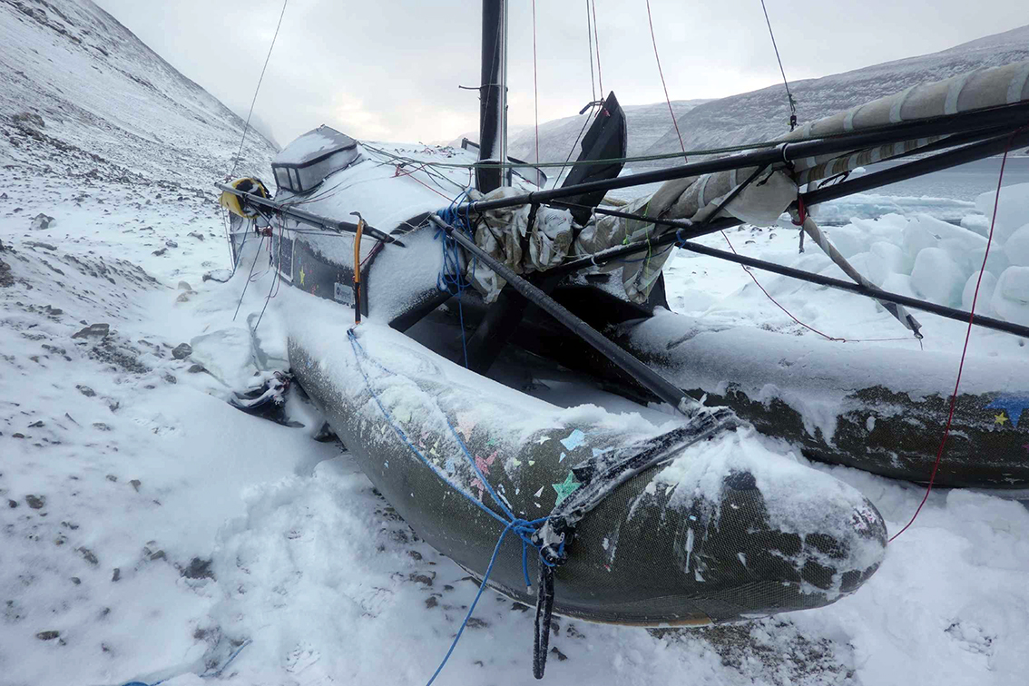
Seb has decided to terminate the Nagalaqa Expedition in the Nares Strait, north of the Kane Basin:
Winds of more than 30 knots are forecast. The weather window didn’t really open. Luckily we’re not on the water, with our wobbly little boat, it would have been catastrophic… Here and now, the winds, the cold, the snow, the darkness remind us that winter is back. The Arctic requires patience, perseverance, but also a large dose of humility. We are waiting for better weather conditions so that a helicopter can take off and pick us up. In a few days, we will leave Babouch-ty, dismasted, coiled in a fold of ground and moored to bags of stones… This expedition ends here for this year.
After a quiet couple of years due to the Covid-19 pandemic there are numerous cruises through the Northwest Passage planned for the summer of 2022. Some (very!) small vessels are also currently scheduled to attempt that perilous journey. First of all let’s take a look at a map of the assorted routes through the Canadian Arctic Archipelago:
plus another map which includes a few more place names:
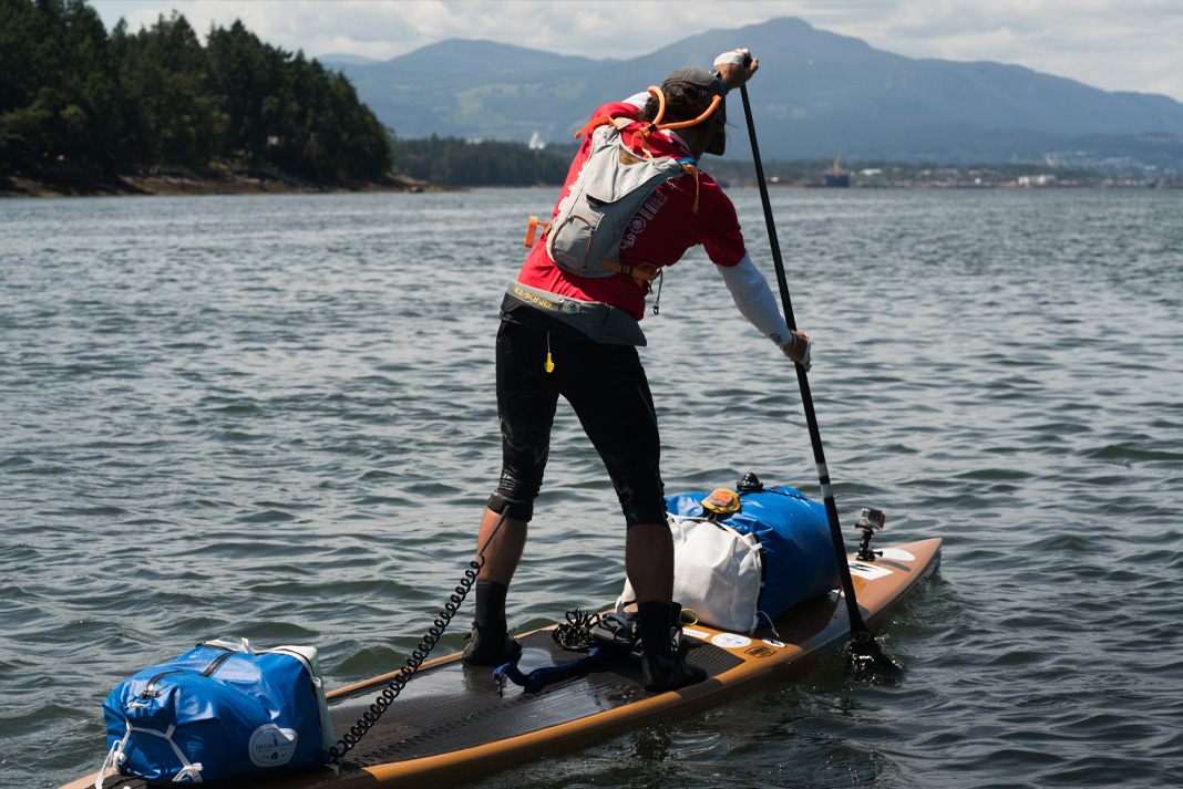
Next comes news of the expeditions planned by a variety of intrepid adventurers. According to Karl Kruger’s web site :
In 2022, Karl will attempt to become the first human to paddle 1,900 miles of the Northwest Passage on a standup paddleboard.
The article at the link is undated, but suggests that Karl initially intended to set off for Pond Inlet from Tuktoyaktuk in July 2019, but postponed the trip until the summer of 2020. By then Covid restrictions were in place, so next month provides the first opportunity for him to attempt the journey once again.
Whilst the Northern Sea Route has opened up early this year, it will be be quite some time before the Northwest Passage follows suit. Nevertheless our old friend Northabout is currently sailing in the direction of Baffin Bay, so now seems as good a time as any to start speculating about the prospects for the Summer of 2020. The passage through Lancaster Sound is already navigable:
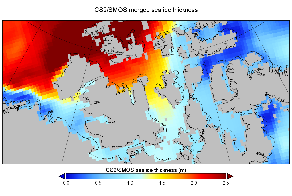
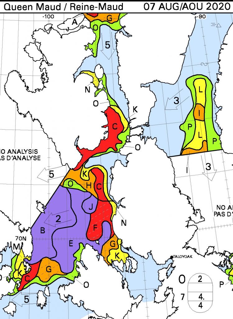
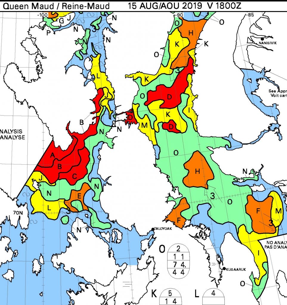
However as the Canadian Ice Service chart also shows, there are still some areas of 7-8/10 concentration along the Beaufort Sea coast en route to the Bering Strait. The central Canadian Arctic Archipelago is solid 9-10/10 at present, but what’s the prognosis? Here’s the final CryoSat-2/SMOS merged thickness map of the winter, from April 15th:
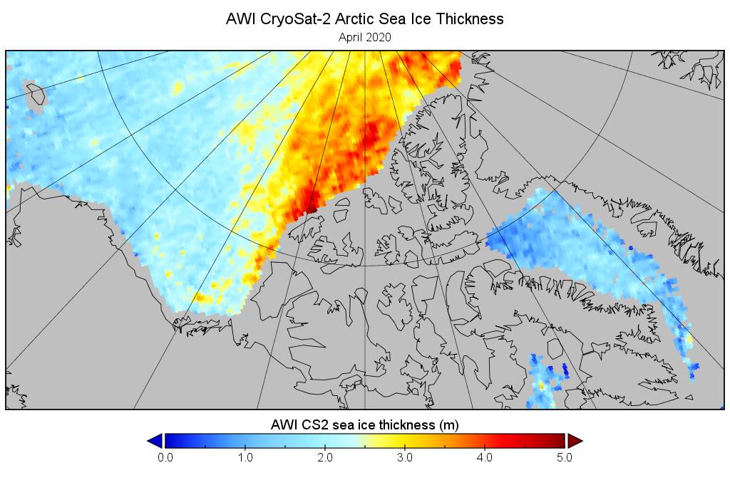
This suggests that the thickest ice on the usual route through the Northwest Passage for small vessels was around 1.2 meters in Larsen Sound. This seemed suspiciously thin to me, so next I tried the underlying Cryosat-2 data from AWI, which revealed this:
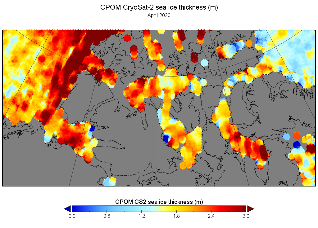
Suspicions confirmed. It looks like AWI are ignoring CS2 data in the CAA for 2020! Here’s how the CPOM Cryosat-2 numbers look for a similar date, which is hopefully nearer the reality:
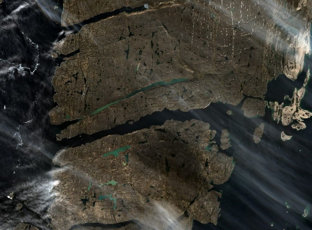
The CAA was fairly cloud free on June 23rd, and this satellite image shows that surface melt had started across the entire central section of the Northwest Passage:
NASA Worldview “false-color”image of the Canadian Arctic Archipelago on June 23rd 2020, derived from the MODIS sensor on the Terra satellite
All in all it looks to me as though “small vessels” will be able to successfully make it through the Northwest Passage later in the summer of 2020, with thicker ice drifting south into Larsen Sound from the McClintock Channel being a potential bottleneck.
[Edit – August 1st]
Whilst there are certainly some cruise ships planning on voyaging through the Northwest Passage this summer it looks as though there will be very few yachts or other small vessels. According to Transport Canada:
To better protect Arctic communities, pleasure craft are prohibited from operating in Canada’s Arctic coastal waters north of the 60th parallel until October 31, 2020, at the earliest:
to limit any potential interaction with remote and vulnerable coastal communities in consideration of minimal health care infrastructure in these waterways that notably comprise the Northwest Passage as well as the territorial sea of Canada surrounding Nunatsiavut, Nunavik and the Labrador Coast).
to allow the Canadian Coast Guard to focus efforts on essential operations including community resupply ice-breaking, environmental response, and search and rescue.
With this proviso:
In the Canadian Arctic coastal waters, the following measures will not apply to:
Foreign pleasure craft exercising their right of innocent passage within the territorial sea. However, any such transits will be subject to receipt of a 60-day written notice in advance of arrival in Canadian Arctic coastal waters to Transport Canada, and be subject to any conditions the Minister determines necessary to ensure the protection of marine personnel and of local communities (for example, additional insurance, rescue strategy).
[Edit – August 6th]
The skies were clear over the Northwest Passage yesterday, and this is what could be seen from the Aqua satellite:
I don’t know about you, but based on that image I reckon a plucky little yacht like Northabout could just about squeeze past the remaining sea ice along the coast of the Boothia Peninsula?
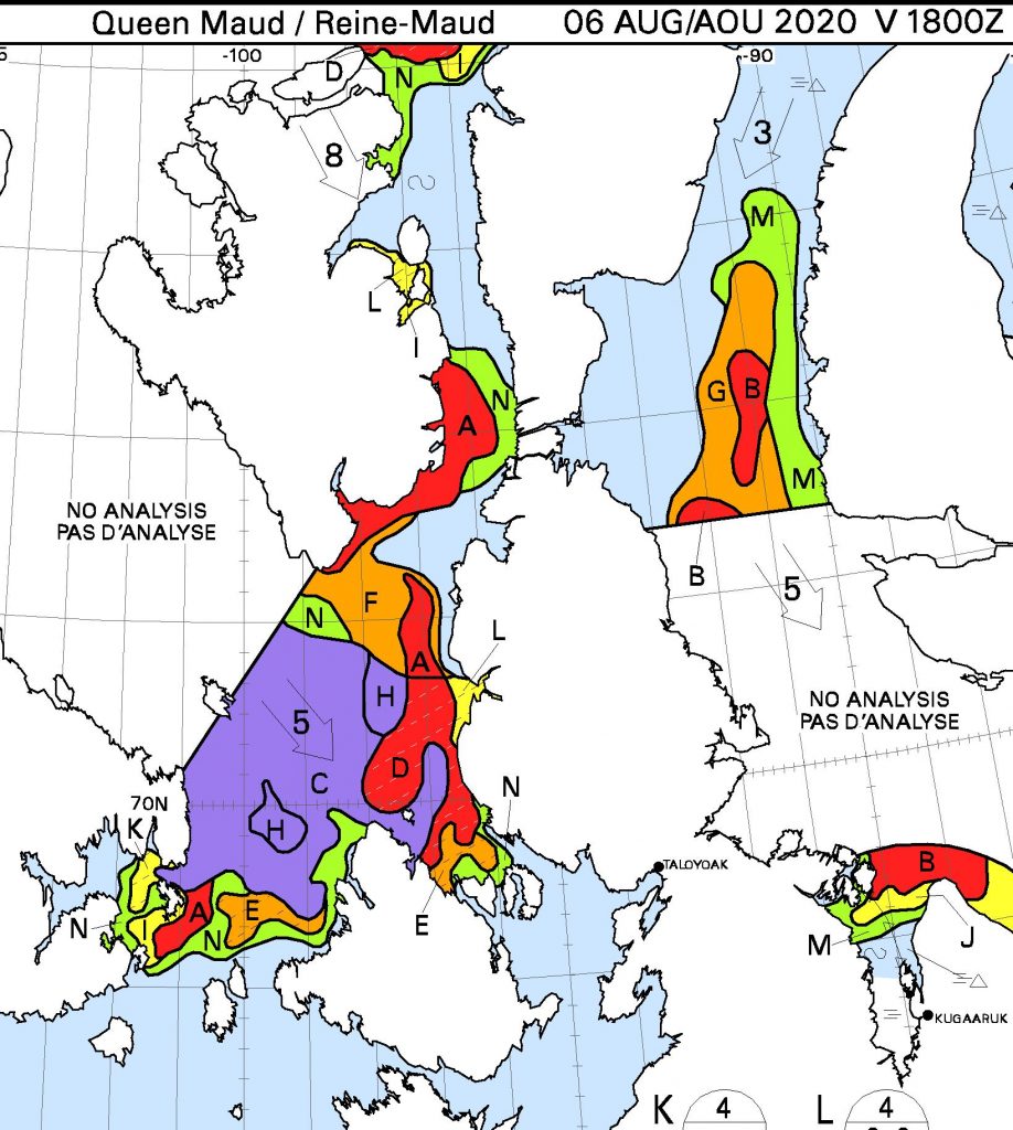
However let’s also take a look at the charts of the Canadian Ice Service shall we? The daily regional maps don’t cover the “squeeze point” yet, but the weekly map dated August 3rd reveals this:
We’re forced to conclude that officially the Northwest Passage isn’t quite “open” yet!
[Edit – August 7th]
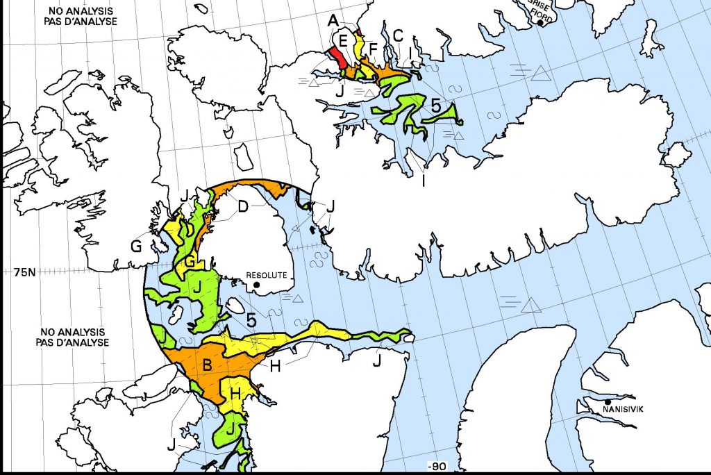
The Canadian Ice Service have extended their daily coverage to the “choke point” we looked at above:
The Northwest Passage is still not “officially” open!
[Edit – August 8th]
The southern “choke point” is still blocking the way, and winds are currently pushing ice into the north of Peel Sound:
This Sentinel 2 image from August 6th shows the Bellot Strait to be completely clear of ice, so despite that route 6 through the Northwest Passage may well be very open soon.
[Edit – August 11th]
Snow White is pleased to announce that she cut the ribbon at the 2020 Northwest Passage route 6 opening ceremony earlier today:
[Edit – August 14th]
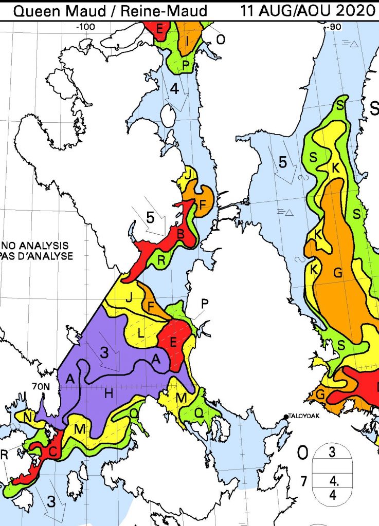
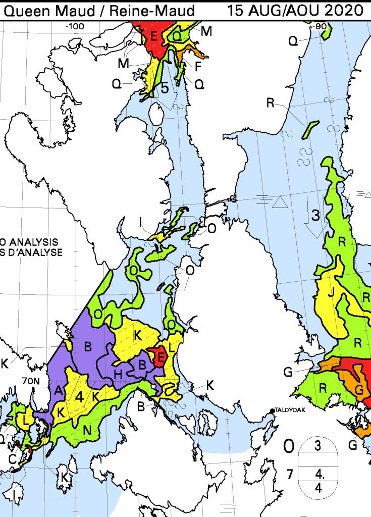
Whilst this is no doubt only temporary, the route along the coast of the Boothia Peninsula is now blocked by an area of 7-8/10 concentration ice:
[Edit – August 16th]
Route 6 is open once again, and it is also now possible to take a circuitous route around the north of both Somerset and King William Islands without encountering anything worse than 6/10 concentration ice:
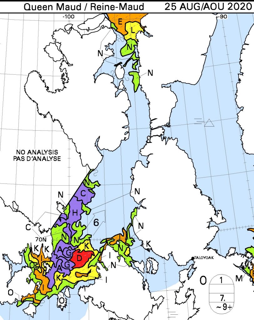
[Edit – August 25th]
As one door opens, another one closes?
[Edit – August 27th]
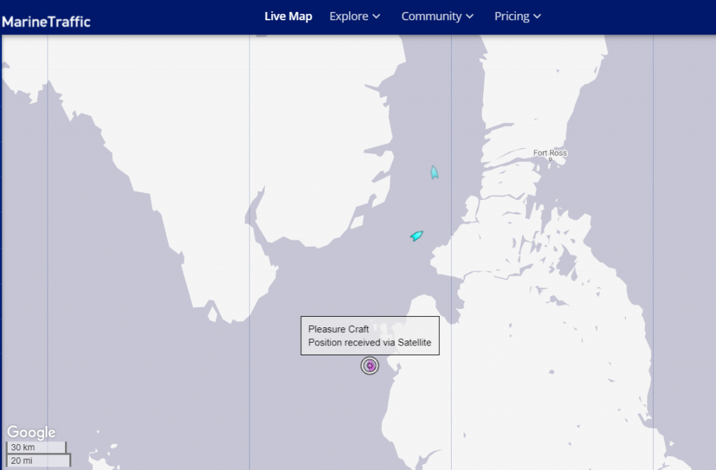
Making one of my periodic visits to MarineTraffic I couldn’t help but notice a “pleasure craft” approaching Bellot Strait!
According to the Canadian government, he has no business being there. But 72-year-old Peter Smith is sailing the Northwest Passage anyway, in violation of COVID-19-related orders prohibiting most foreign yachts from entering Canadian waters.
But according to a Facebook post on Aug. 20, Bobby Klengenberg, a local observer with the Inuit Marine Monitoring Program, spotted Smith’s custom yacht, the Kiwi Roa, off the coast of Cambridge Bay, Nunavut.
Transport Canada confirmed the sighting in an email to CBC News, and said the vessel was told “to depart Canadian waters and not make landfall.”
A spokesperson said the Canadian Coast Guard will “monitor the vessel’s transit out of the region.” If Smith is indeed found to have broken the law, they wrote, the agency “will not hesitate to take appropriate enforcement action,” including penalties of up to $5,000.
Regular readers may recall our coverage of the plucky little yacht Northabout’s circumnavigation of the Arctic in 2016? We are delighted to be able to inform you that (s)he is intent on heading back to the Northwest Passage once again next year, intending to travel from east to west this time around.
Meanwhile this year the plan is to visit the west coast of Greenland before returning to Jersey for the winter. Here’s how the news was announced on the local television channel here in South West England:
Northabout is the means of transport employed by Tobias Carter and Sophie Simonin of the Unu Mondo expedition as they attempt to “Enrich the Knowledge of the Arctic World with Scientific Projects” amongst other things:
Unu Mondo is a 4months sailing expedition into the Arcticaimed to gather scientific data and testimonies from local communities to better anticipate climate change and promote concrete actions.
Leaving fromSaint-Malo, France it will reach Greenland (2020) then Alaska through the famous Northwest Passage (2021), stopping on the road in the villages of the West coast of Greenland and will culminate in a documentary.
Unu Mondo team is composed of 2 skippers, a handful of scientists and a pinch of audiovisual professionals.
According to the timeline on the expedition web site Tobias and Sophie originally intended to set sail from France at the end of May. However plans seem to have changed, in part because Sophie recently tested positive for Covid-19. According to the Unu Mondo Facebook page Northabout actually set off for the Arctic from Roscoff on July 7th. Here’s the Unu Mondo Expedition’s latest bilingual video update, which amongst other things reveals Northabout’s somewhat cramped interior:
[Edit – July 14th]
Currently Northabout has reached the middle of the North Atlantic, as revealed by the Unu Mondo live tracking map:
[Edit – July 21st]
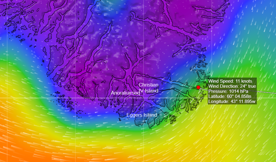
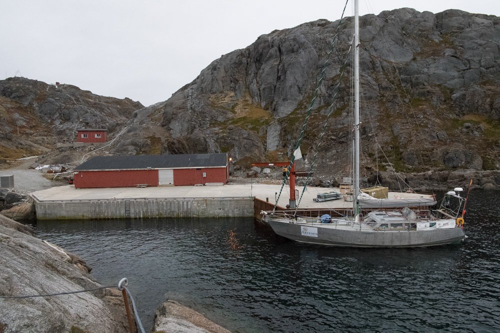
The Unu Mondo Expedition team have reached Prince Christian Sound, just north of Cape Farewell in Southern Greenland:
Northabout was last there in October 2016. Here’s what the scenery looks like:
When Northabout was still 400 nautical miles from Greenland the team released a Météo France drifting weather buoy into the North Atlantic:
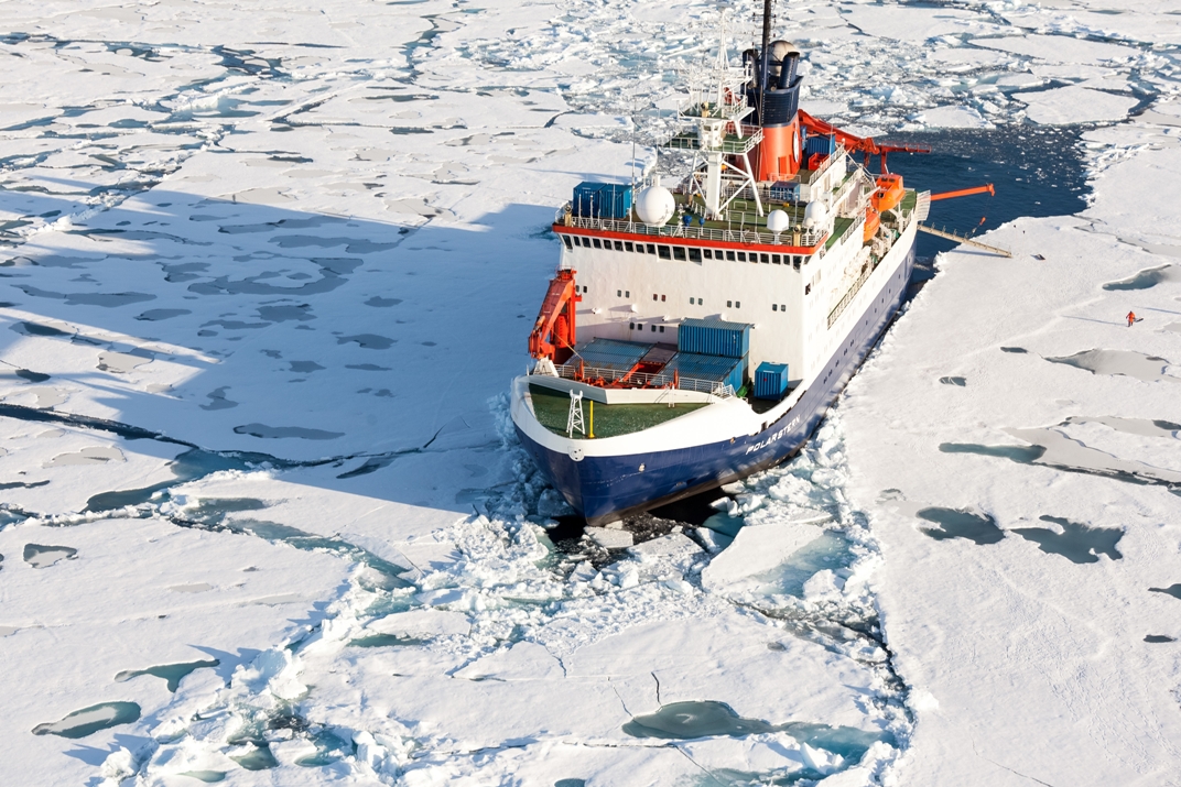
In September 2019, the German research icebreaker Polarstern will set sail from Tromsø, Norway, to spend a year drifting through the Arctic Ocean – trapped in ice. The goal of the MOSAiC expedition is to take the closest look ever at the Arctic as the epicenter of global warming and to gain fundamental insights that are key to better understand global climate change.
In essence Polarstern will be following in the illustrious footsteps of Tara and Fridtjof Nansen‘s Fram before her, but with vastly more scientists in attendance than previous transpolar drift expeditions.
Hundreds of researchers from 19 countries take part in this exceptional endeavour. The MOSAiC expedition will bring a modern research icebreaker close to the north pole for a full year including for the first time in polar winter. The data gathered will be used by scientists around the globe to take climate research to a completely new level.
The expedition also bears a lot of resemblance to the more recent Norwegian Young Sea ICE Expedition, during which R/V Lance drifted embedded in winter sea ice, albeit nearer the North Atlantic.
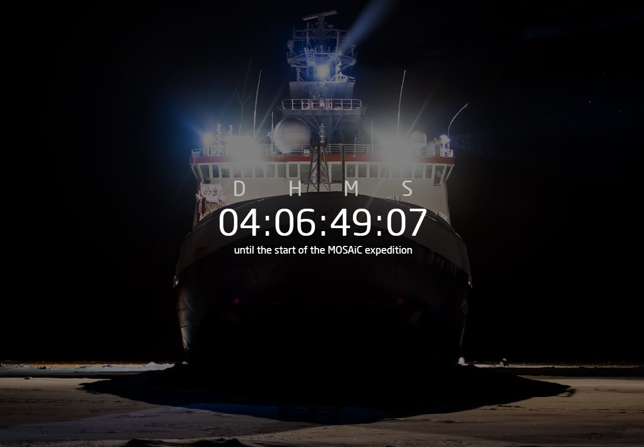
The countdown to “the largest polar expedition in history” has begun:
Here’s an infographic to help explain what happens next:
[Edit – September 20th]
The moment has arrived. The countdown is complete and the MOSAiC expedition begins today. According to the expedition web site:
After a decade of preparations, it’s finally time: this evening at 8:30 p.m. the German icebreaker Polarstern will depart from the Norwegian port of Tromsø. Escorted by the Russian icebreaker Akademik Fedorov, she will set sail for the Central Arctic. On board researchers will investigate a region that is virtually inaccessible in winter, and which is crucial for the global climate. They will gather urgently needed data on the interactions between the atmosphere, ocean and sea ice, as well as on the ecosystem. Thanks to the collaboration between international experts, the one-year-long ice drift past the North Pole will take climate research to a completely new level.
At the launch of MOSAiC Markus Rex, Head of the expedition from the Alfred Wegener Institute said that:
This mission is ground breaking. Never before has there been such a complex Arctic expedition. For the first time we will be able to measure the climate processes in the Central Arctic in winter. And so for the first time we will be able to understand this region and correctly represent it in climate models. The Arctic is the epicentre of global warming and has already undergone dramatic changes. And it is the weather kitchen for our weather in Europe. Extreme weather conditions like outbreaks of cold Arctic air here in winter, or heat waves in summer are linked to the changes in the Arctic. At the same time, the uncertainties in our climate models are nowhere bigger than in the Arctic. There aren’t any reliable prognoses of how the Arctic climate will develop further or what that will mean for our weather. Our mission is to change that.
Here’s the Alfred Wegener Institute’s 3 hour plus recording of the send off for Polarstern and Akademik Federov from Tromsø:
Here too are some alternative sources of information about the expedition:
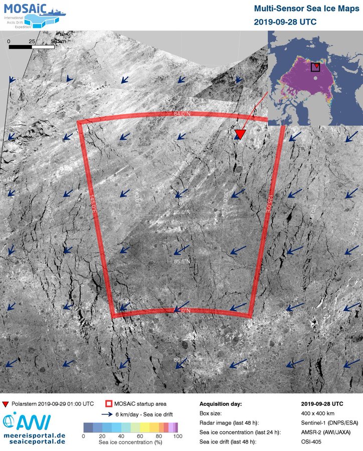
Polarstern is now within the initial target area, and is looking for a suitable ice floe to which she can attach herself:
Together with some other scientists, the head of MOSAiC, Markus Rex, flies over from #Polarstern to Akademik Fedorov, where they plan the next steps of searching for the right ice floe. #MOSAiCexpedition#Icedrift#Arctic
According to an article by Janek Uin from Brookhaven National Laboratory on the United States’ Department of Energy Atmospheric Radiation Measurement web site:
We finally found the piece of ice that will be the home for Polarstern for the next year. It’s a floe a few kilometers in diameter and with thickness ranging from half a meter to a few meters. Several ice floes were surveyed via helicopters from both icebreakers and by teams of scientists taking measurements on ice before a decision to pick this one was made. Now the two icebreakers are tied together as equipment, fuel, and people are transferred between the ships in preparation for deployment. While it’s exciting to see many new faces on Polarstern, we also had to say goodbye to some of the friends we had made on our way here.
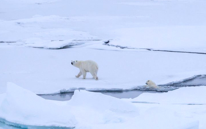
There was also a lot of excitement today as two polar bears—a mom with her cub—wandered very close to Polarstern. Everybody who could rushed to the deck to try to capture photos of them in the diminishing daylight.
[Edit – October 7th]
Via the MOSAiC Expedition Twitter feed:
On Friday evening at 9:30 p.m. boat time the team of #MOSAiCexpedition reached their destination: the floe which had been chosen some days before. #Icedrift#Arctic
It is perhaps rather early to start speculating about if, and when, the Northwest Passage will become navigable for the host of small vessels eager to traverse it this summer.
However one such vessel is already en route to the Arctic Circle, so why don’t we take a look at its live tracking map?
Moli (Mo for short) is being piloted singlehandedly by Randall Reeves, who has already circumnavigated Antarctica and is hell bent on circumnavigating America too!
According to Randall’s last but one update he’ll be stopping in St. Johns before heading for the Arctic Circle:
“Have you explained why your first stop is St John’s?” asked a friend recently, “Not New York, Boston, Camden, Lunenberg, Halifax, to name just, well, five?”
It is a good question, and the answer is simple: I never considered going anywhere else because a) St John’s is decidedly on the Figure 8 route and b) it has the required marine facilities and big grocery stores. And did I mention, it’s right on the route?
Actually, I did flirt briefly with the idea of Boston, thinking that goods there would be cheaper and marine facilities, more diverse. And though it does save some 500 miles of sailing on this inbound leg, Boston is so far west that it adds 1,000 miles to the leg up to the Arctic. So, I’ve decided to stick to the most logical stop.
St. John’s is less than a thousand miles north now. In any worthy wind, we’d be there before the end of the month. But when your average speed is 3.9 knots…you don’t do the when-do-we-make-port math.
Interestingly the background to Moli’s live tracking map is from Windy.com.
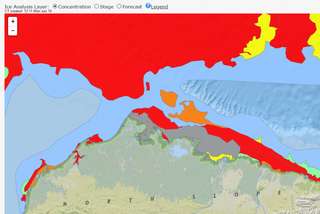
[Edit – June 10th]
It’s very early in the melting season to be reporting on this event, but any early bird traversing the Northwest Passage from west to east could now sail through open water around Point Barrow, along the Alaskan and Canadian coast and into the Amundsen Gulf. Here’s the latest sea ice concentration chart for Alaskan waters from the US National Weather Service:
Whilst we’re here why don’t we take a look at how Randall is getting along in Moli. According to his latest blog post he is now in Halifax scraping barnacles off Moli’s bottom!
On Friday, June 8, day 245 of the Figure 8 Voyage, I hauled Mo here at the Royal Nova Scotia Yacht Squadron. My expectations were that the bum would be nearly spotless. Instead, we had a new crop of hitchhikers coming in at the base of those older barnacles that remained.
Lessons Learned: “There is no good bottom paint for aluminum boats,” says my friend, fellow cruiser, and aluminum boat builder, Gerd Marggraff. Prior to departure, I had applied three generous coats of a bottom paint known specifically to ward off hard growth, but barnacles are superior beings, able to penetrate even the best defenses.
An early jump. I might have had an easier time of it if I’d dived the hull before the first Cape Horn rounding, when the barnacles were young and few.
In hindsight, I think I could have dived the hull with some success, even when the barnacles had matured into a reef. I found here in the yard that the “hold fast” (the glue that holds the barnacle fast to the hull) was easier to remove with a sharpened spatula than I had thought. It would have been a big job, taking a full day or more–but not impossible.
[Edit – June 15th]
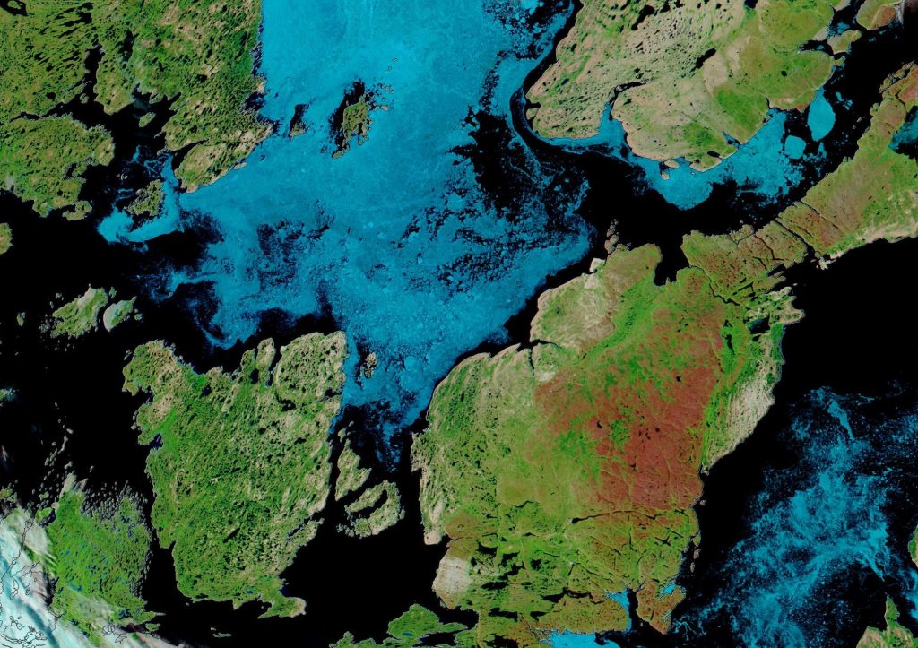
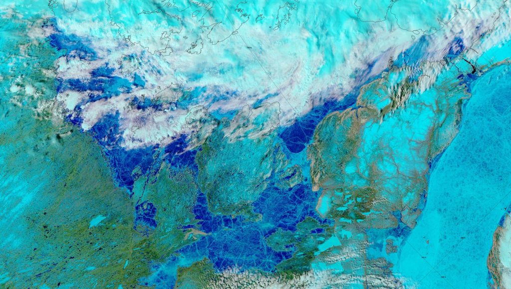
Delving deeper into the Canadian Arctic Archipelago, the clouds have cleared over “Amundsen’s Route” through the Northwest Passage to reveal extensive melt ponding:
NASA Worldview “false-color” image of the Northwest Passage on June 14th 2019, derived from the MODIS sensor on the Terra satellite
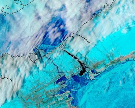
Bellot Strait appears to be largely free of sea ice already:
[Edit – August 16th]
After a tense wait Bellot Strait has recently become blocked by 9/10 concentration sea ice but the southern route through the Northwest Passage via Peel Sound is now open to any vessel willing to cope with 6/10 concentration or less:
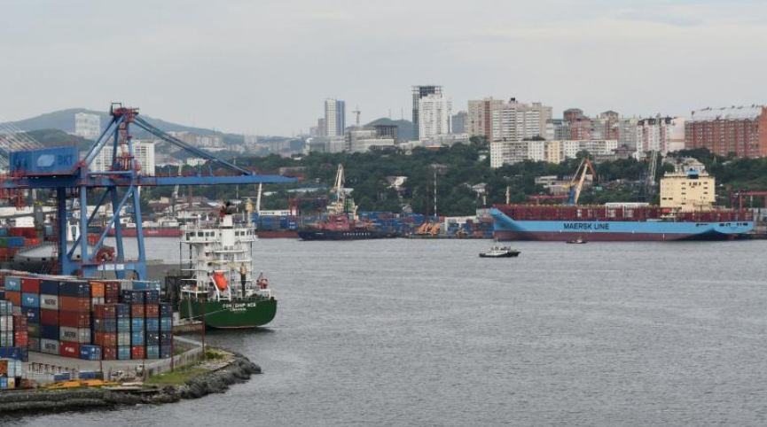
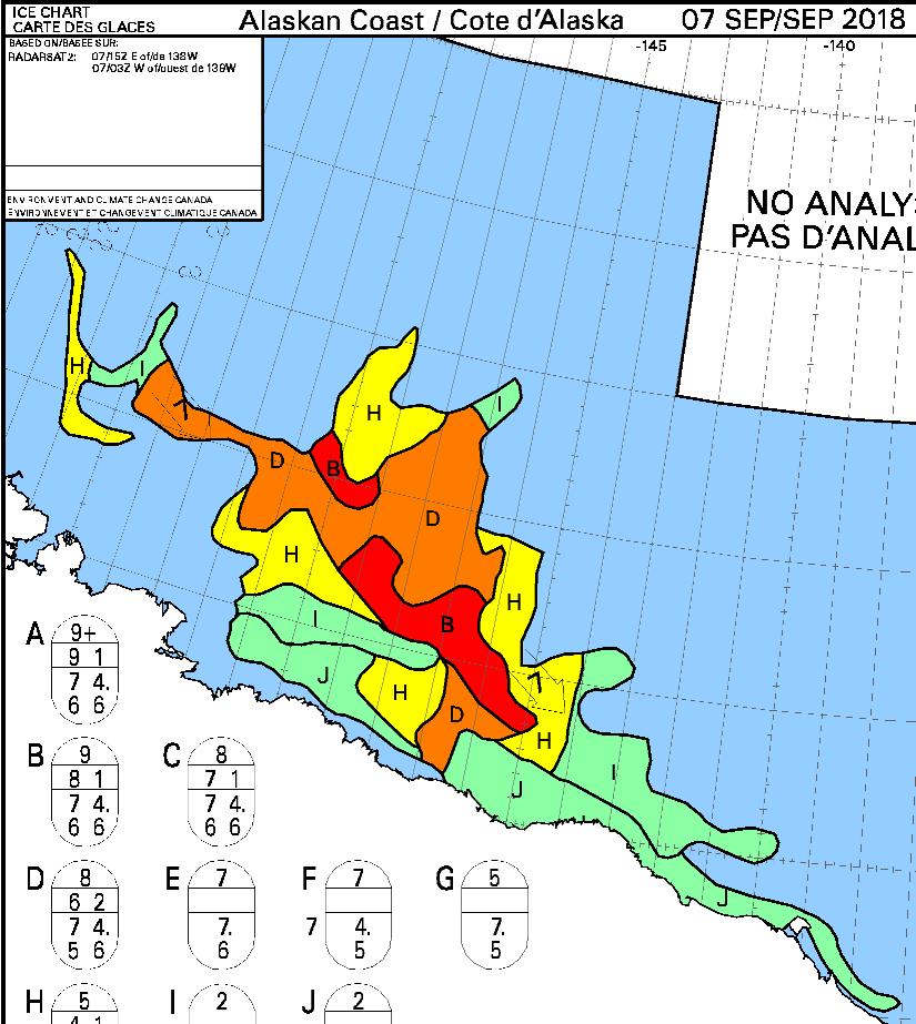
Our usual excuse for an article such as this is an attempt by a “pleasure craft” such as the plucky little yacht Northabout to journey past Russia’s northern shores. I’m not aware of any such plans for this year, but here is some interesting NSR 2018 news. According to Reuters:
A Maersk vessel loaded with Russian fish and South Korean electronics will next week become the first container ship to navigate an Arctic sea route that Russia hopes will become a new shipping highway.
The Arctic voyage by the 3,600 20-foot container capacity Venta Maersk is the latest step in the expansion of the so-called Northern Sea Route which is becoming more accessible to ships as climate change reduces the amount of sea ice.
The brand new Venta Maersk, one of the world’s largest ice-class vessels, will also collect scientific data, said Maersk, underlining that the voyage is a one-off trial for now.
The press release continues:
The decision by Maersk, the world’s biggest container shipping group, to test out the route is a positive sign for Russia, which hopes this could become a mini Suez Canal, cutting sea transport times from Asia to Europe.
“A well-respected company like Maersk sending a container ship through the Arctic, definitely signals there’s something there,” Malte Humpert, a senior fellow at U.S.-based think-tank Arctic Institute, said.
“Currently, we do not see the Northern Sea Route as an alternative to our usual routes. Today, the passage is only feasible for around three months a year which may change with time,” a spokeswoman for Maersk said.
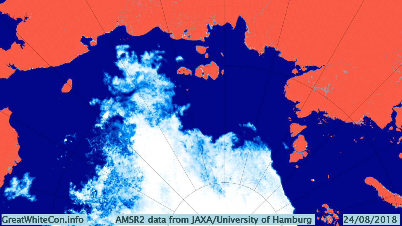
Here’s the sea ice situation that the Venta Maersk is heading for:
According to AMSR2 there’s still some sea ice quite close to shore in the East Siberian Sea. Meanwhile according to Marine Traffic the Venta Maersk has already left Vladivostok:
It will be a little while before she’s braving the dangers of the sea ice in the East Siberian Sea. Hopefully by that time we’ll have some clear satellite images at visual frequencies of anything solid in the path of all those containers. In the meantime here’s a glimpse through the clouds of the approximate ice edge on August 23rd:
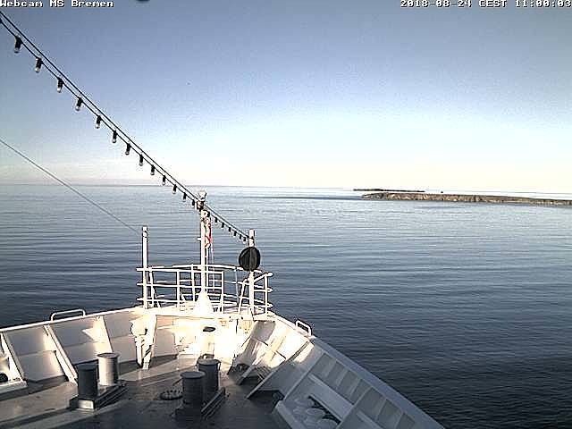
Meanwhile the Hapag Lloyd cruise ship Bremen is currently en route from Tromso to Nome via the Northern Sea Route. She is currently crossing the Laptev Sea heading for the ESS “choke point” from the opposite direction:
The time has come to start speculating about if, and when, the Northwest Passage will become navigable for the host of small vessels eager to traverse it this summer. Almost one month later than in 2017!
Whilst the eastern and western entrances to the assorted routes through the Canadian Arctic Archipelaga have been empty of sea ice for quite some time, the central section between Bellot Strait and Gjoa Haven and/or Cambridge Bay is still chock a block:
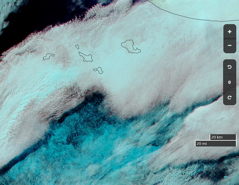
In the east here is a drone’s eye view of Cumming Inlet, courtesy of the Polish team of Michał and Ola Palczyński aboard S/V Crystal:
created by dji camera
It’s not entirely clear when that picture was taken, since according to Michał’s blog:
The waters beyond the Bellot Strait are covered with impassable ice, and the ice in the Beaufort Sea has 90% concentration in some places and reaches up to the shore. In this difficult situation, by 15th August two yachts have already given up and turned back to Greenland (including Blue Peter from our cove).
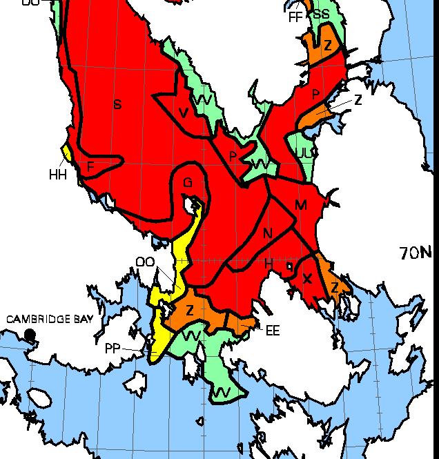
Here’s what lies ahead of Crystal and her remaining companions, according to the Canadian Ice Service:
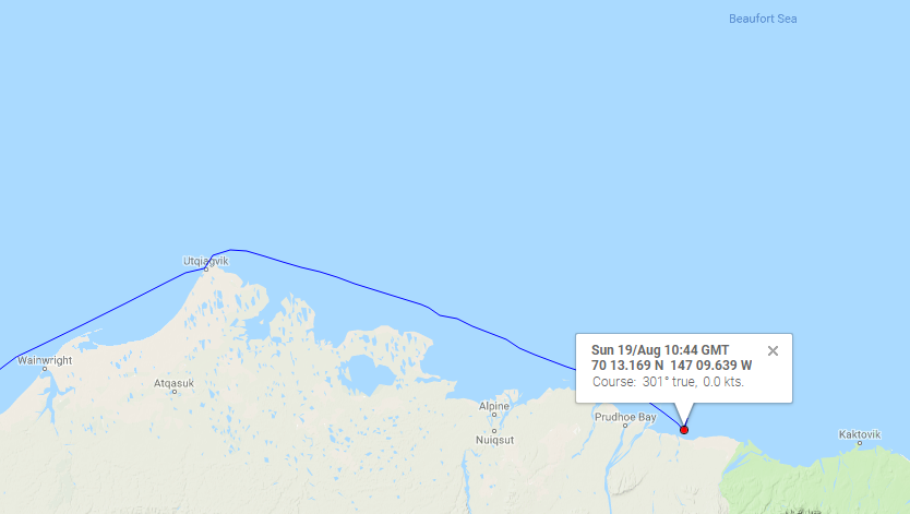
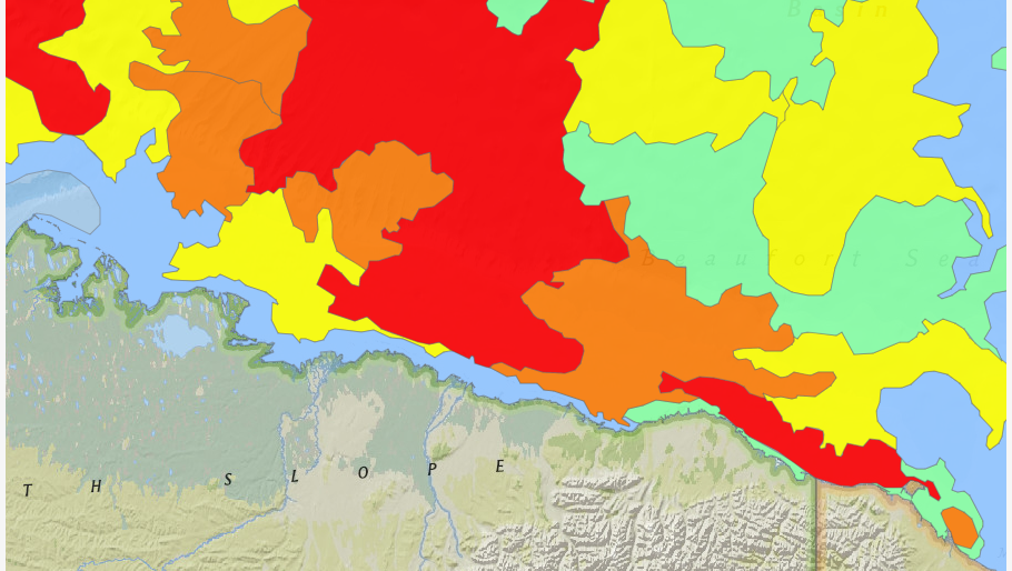
Meanwhile in the Beaufort Sea S/V Dogbark has been battling her way through that “90% concentration” sea ice. Dogbark has now made it as far as Mikkelsen Bay, just past Prudhoe Bay in Alaska:
What does 7/10ths ice mean? We don’t want to know! It is more ice than we want to try and pass, that’s for sure. But the ice charts we look at refer to ice by % of sea coverage, so 7/10ths would look like water mostly covered by large, immovable objects. 5/10ths was as much as we have seen, and we got out of there as fast as we could with some help from our flying eyeball. See Dogbark’s Facebook page for a quick snippet of less dangerous ice.
Meanwhile the Canadian icebreaker CCGS Amundsen has sailed past Arctic Bay and Resolute:
I cannot help but wonder what vessels might be closely following in his wake?
[Edit – September 7th]
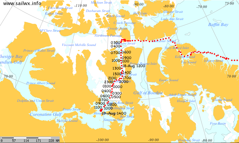
Finally there comes news that a “pleasure craft” has made it through the Canadian Arctic Archipelago from east to west as far as Tuktoyaktuk. I’d been wondering which vessel it was that seemed immobile near the western end of the Bellot Strait on the MarineTraffic maps. This one’s from August 19th:
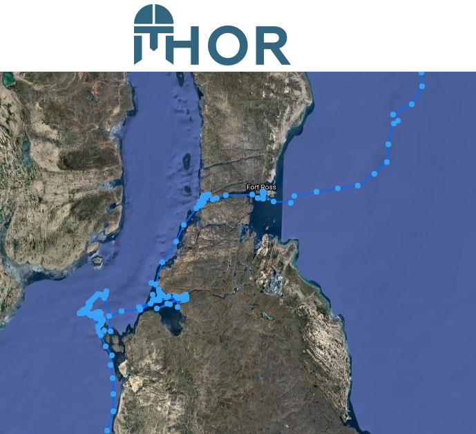
Now I know! Thanks to a heads up on the Arctic Sea Ice Forum I’ve discovered that it’s the S/V Thor. Here’s the tracking map of his efforts to get through all the old ice in the vicinty.
The map reveals that Thor made it through the Bellot Strait on August 6th, but didn’t manage to make significant headway out of the Franklin Strait until August 28th.
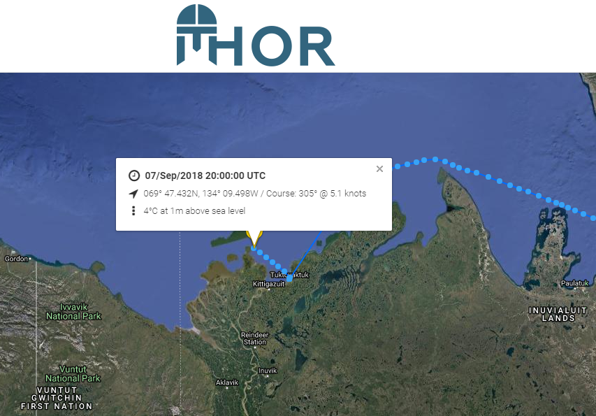
Thor departed from Tuk earlier today:
He now only has this to contend with:
This website uses cookies to improve your experience. We'll assume you're ok with this, but you can opt-out if you wish. Cookie settingsACCEPT
Privacy & Cookies Policy
Privacy Overview
This website uses cookies to improve your experience while you navigate through the website. Out of these, the cookies that are categorized as necessary are stored on your browser as they are essential for the working of basic functionalities of the website. We also use third-party cookies that help us analyze and understand how you use this website. These cookies will be stored in your browser only with your consent. You also have the option to opt-out of these cookies. But opting out of some of these cookies may affect your browsing experience.
Necessary cookies are absolutely essential for the website to function properly. This category only includes cookies that ensures basic functionalities and security features of the website. These cookies do not store any personal information.
Any cookies that may not be particularly necessary for the website to function and is used specifically to collect user personal data via analytics, ads, other embedded contents are termed as non-necessary cookies. It is mandatory to procure user consent prior to running these cookies on your website.