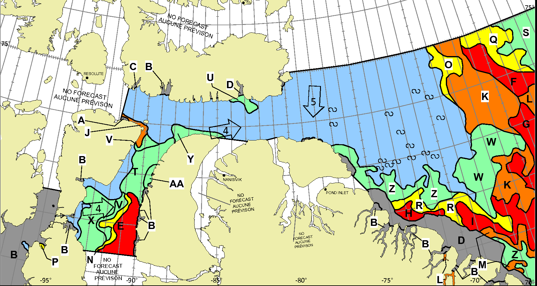
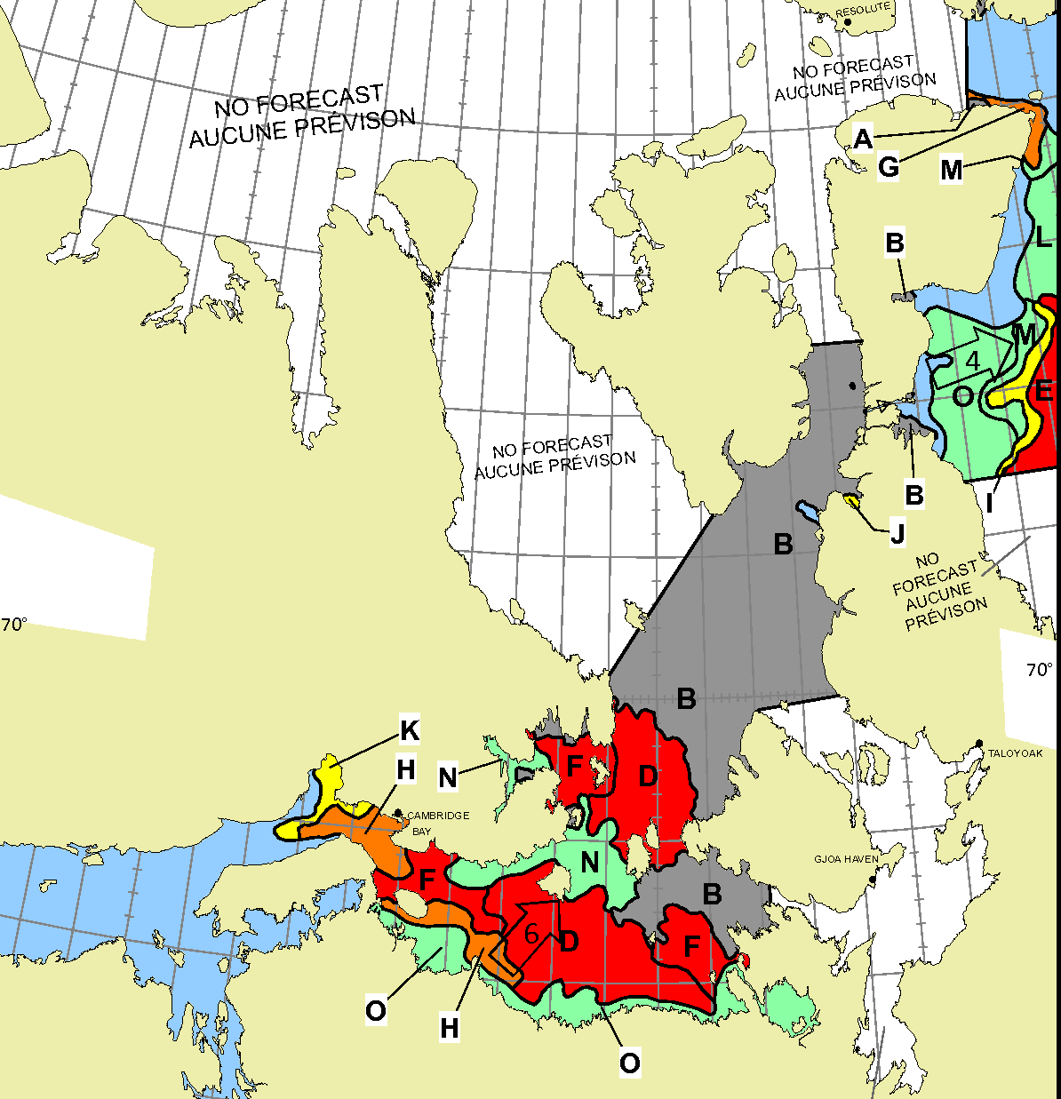
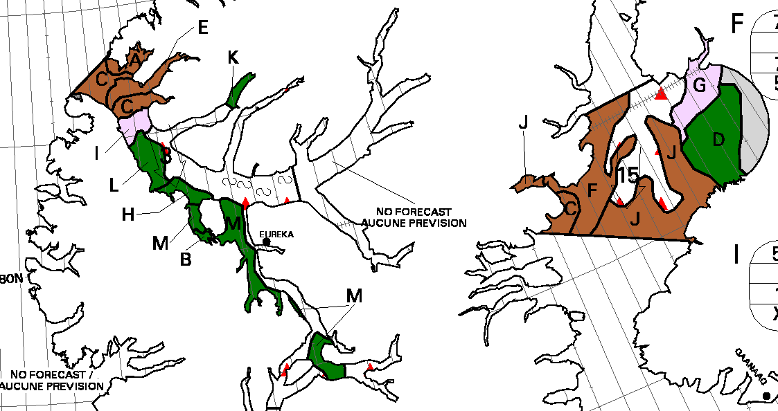
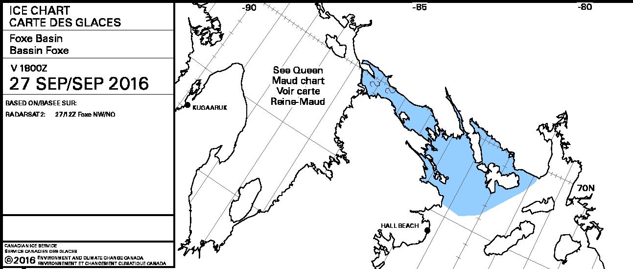
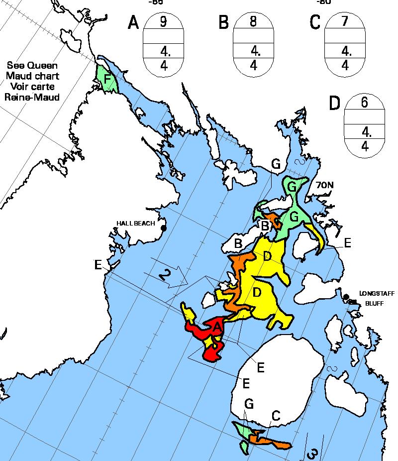
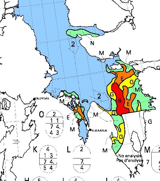
Some “pleasure craft” are currently heading up the west coast of Greenland en route to the Bering Strait via Lancaster Sound and one of the assorted routes through the Canadian Arctic Archipelago. For those of you unfamiliar with the geography of the Northwest Passage, here are couple of hopefully helpful maps:
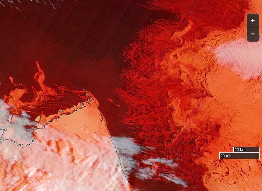
Whilst there is still ice blocking the route across Baffin Bay from Greenland, the Canadian Ice Service has already started daily coverage of the heart of the southern route through the Northwest Passage. There’s plenty of open water in Lancaster Sound and low concentration sea ice in Prince Regent Inlet:
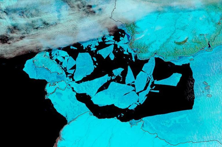
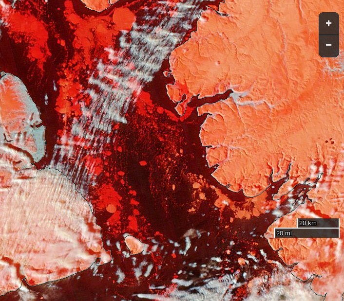
Further south there is also open water in the Coronation Gulf, but the fast ice between Peel Sound and King William Island has not yet started breaking up:
This slightly cloudy satellite image of the Canadian Arctic Archipelago also shows that the exit of the northern route via McClure Strait into the Beaufort Sea is already navigable:
The 2023 Arctic Report Card has been published by the US National Oceanic and Atmospheric Administration (NOAA). All sorts of things are discussed in the report, but sticking to Snow White’s speciality of sea ice here’s an extract:
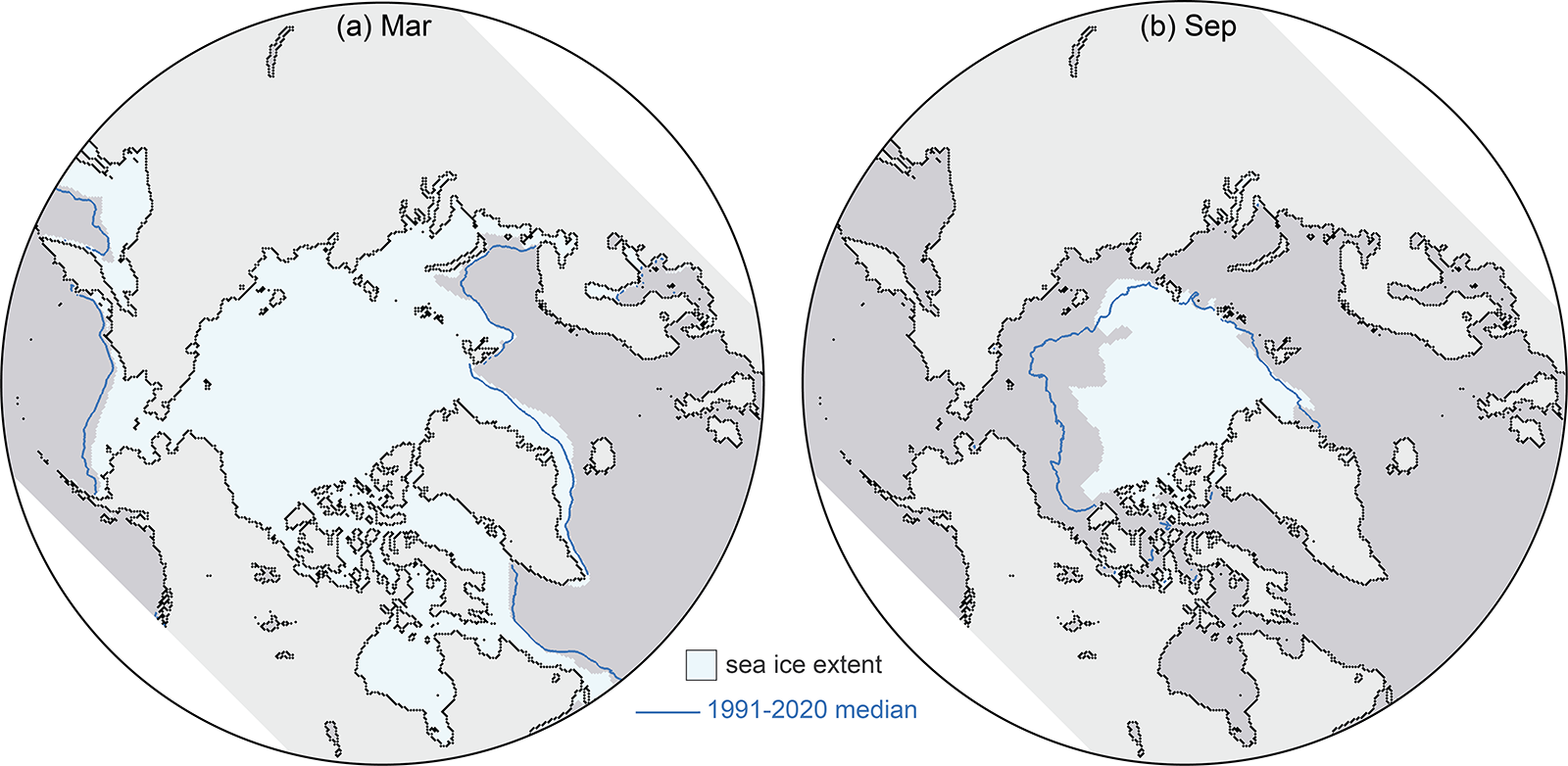
This satellite record tracks long-term trends, variability, and seasonal changes from the annual extent maximum in late February or March and the annual extent minimum in September. Extents in recent years are ~50% lower than values in the 1980s. In 2023, March and September extents were lower than other recent years, and though not a new record low, they continue the long-term downward trends:
March 2023 was marked by low sea ice extent around most of the perimeter of the sea ice edge, with the exception of the East Greenland Sea where extent was near normal. At the beginning of the melt season, ice retreat was initially fairly slow through April. In May and June, retreat increased to a near-average rate, and then accelerated further through July and August. By mid-July, the ice had retreated from much of the Alaskan and eastern Siberian coast and Hudson Bay had nearly melted out completely. In August, sea ice retreat was particularly pronounced on the Pacific side, opening up vast areas of the Beaufort, Chukchi, and East Siberian Seas. Summer extent remained closer to average on the Atlantic side, in the Laptev, Kara, and Barents Seas
The Northern Sea Route, along the northern Russian coast, was relatively slow to open as sea ice extended to the coast in the eastern Kara Sea and the East Siberian Sea, but by late August, open water was found along the coast through the entire route. The Northwest Passage through the Canadian Archipelago became relatively clear of ice, though ice continued to largely block the western end of the northern route through M’Clure Strait through the melt season. Nonetheless, summer 2023 extent in the Passage was among the lowest observed in the satellite record, based on Canadian Ice Service ice charts.
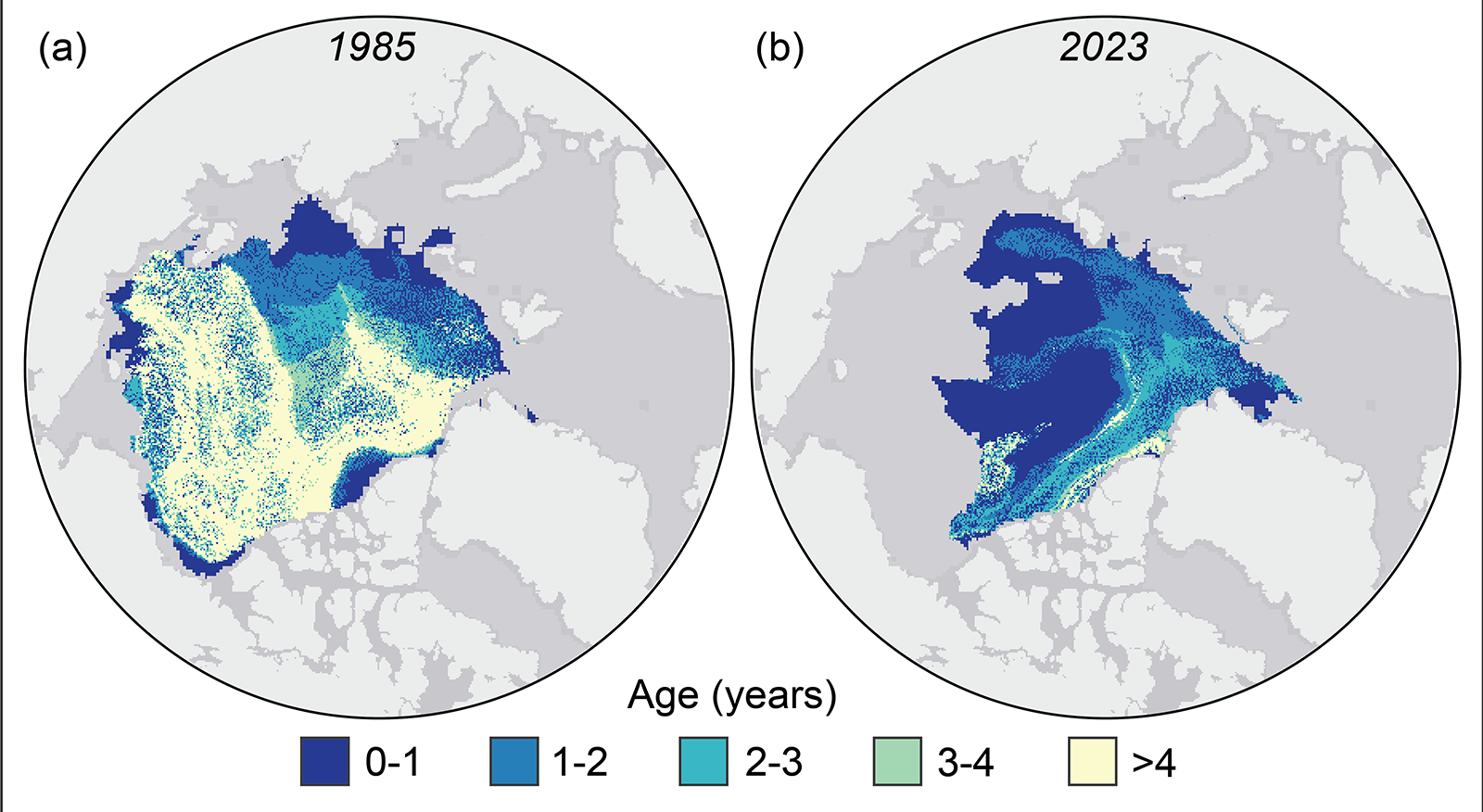
Tracking the motion of ice in passive microwave imagery using feature tracking algorithms can be used to infer sea ice age. Age is a proxy for ice thickness because multiyear ice generally grows thicker through successive winter periods. Multiyear ice extent has shown interannual oscillations but no clear trend since 2007, reflecting variability in the summer sea ice melt and export out of the Arctic. After a year when substantial multiyear ice is lost, a much larger area of first-year ice generally takes its place. Some of this first-year ice can persist through the following summer, contributing to the replenishment of the multiyear ice extent:
However, old ice (here defined as >4 years old) has remained consistently low since 2012. Thus, unlike in earlier decades, multiyear ice does not remain in the Arctic for many years. At the end of the summer 2023 melt season, multiyear ice extent was similar to 2022 values, far below multiyear extents in the 1980s and 1990s:
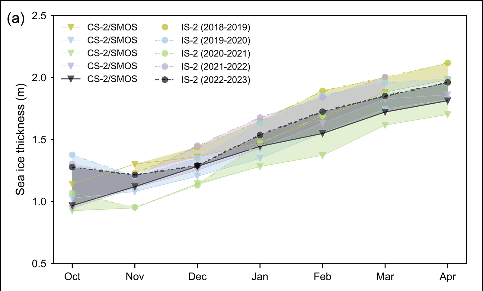
Estimates of sea ice thickness from satellite altimetry can be used to more directly track this important metric of sea ice conditions, although the data record is shorter than for extent and ice age. Data from ICESat-2 and CryoSat-2/SMOS satellite products tracking the seasonal October to April winter ice growth over the past four years (when all missions have been in operation) show a mean thickness generally thinner than the 2021/22 winter but with seasonal growth typical of recent winters:
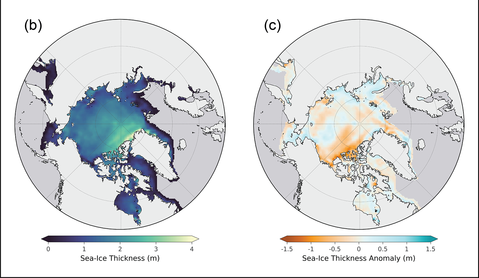
April 2023 thickness from CryoSat-2/SMOS relative to the 2011-22 April mean shows that the eastern Beaufort Sea and the East Siberian Sea had relatively thinner sea ice than the 2011-22 mean, particularly near the Canadian Archipelago. Thickness was higher than average in much of the Laptev and Kara Seas and along the west and northwest coast of Alaska, extending northward toward the pole. The East Greenland Sea had a mixture of thicker and thinner than average ice:
An excellent analysis (IMHO!), but I do have one quibble. I was following events in the Northwest Passage very closely last summer, and according to the Canadian Ice Service on September 1st:
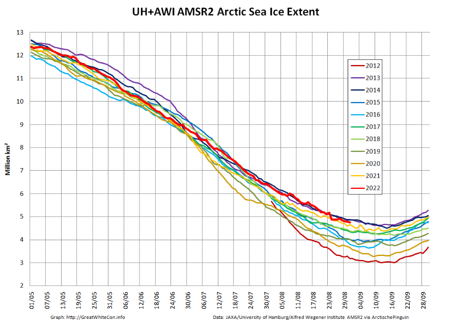
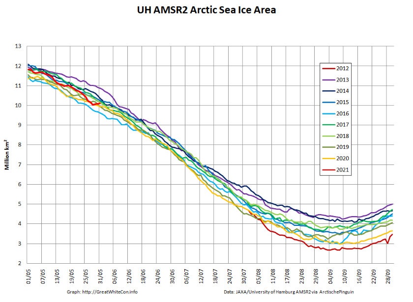
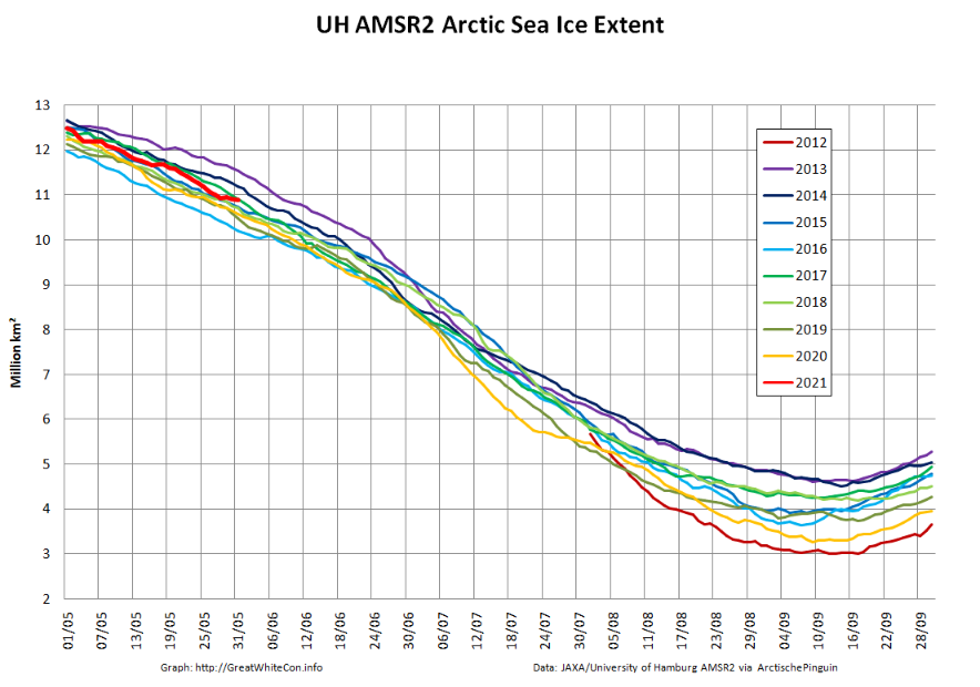
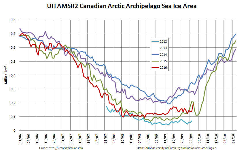
As in previous years there is already a thread devoted to this year’s minimum extent. By way of a summary here are the end of August numbers for our favourite “high resolution” AMSR2 area and extent metrics:
Extent is currently near the top of the range of the last 10 years.
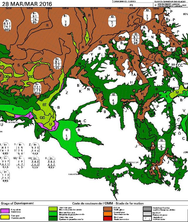
We have now reached the stage of the “melting season” when “refreezing” has started in the Central Arctic but melting at the periphery is outpacing it. However the Canadian Ice Service stage of development charts now show the arrival of new ice in the high latitudes of the Canadian Arctic Archipelago:
After a quiet couple of years due to the Covid-19 pandemic there are numerous cruises through the Northwest Passage planned for the summer of 2022. Some (very!) small vessels are also currently scheduled to attempt that perilous journey. First of all let’s take a look at a map of the assorted routes through the Canadian Arctic Archipelago:
plus another map which includes a few more place names:
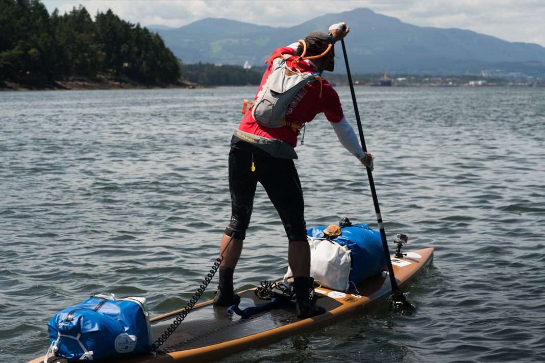
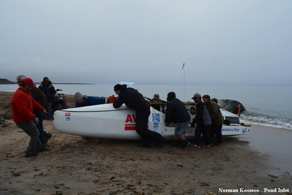
Next comes news of the expeditions planned by a variety of intrepid adventurers. According to Karl Kruger’s web site :
In 2022, Karl will attempt to become the first human to paddle 1,900 miles of the Northwest Passage on a standup paddleboard.
The article at the link is undated, but suggests that Karl initially intended to set off for Pond Inlet from Tuktoyaktuk in July 2019, but postponed the trip until the summer of 2020. By then Covid restrictions were in place, so next month provides the first opportunity for him to attempt the journey once again.
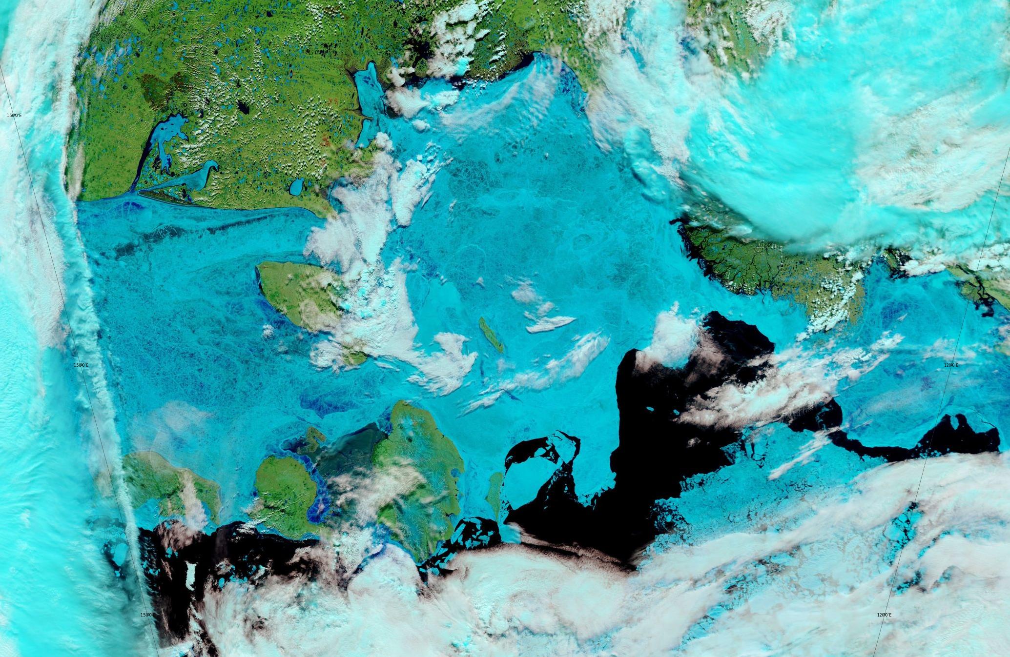
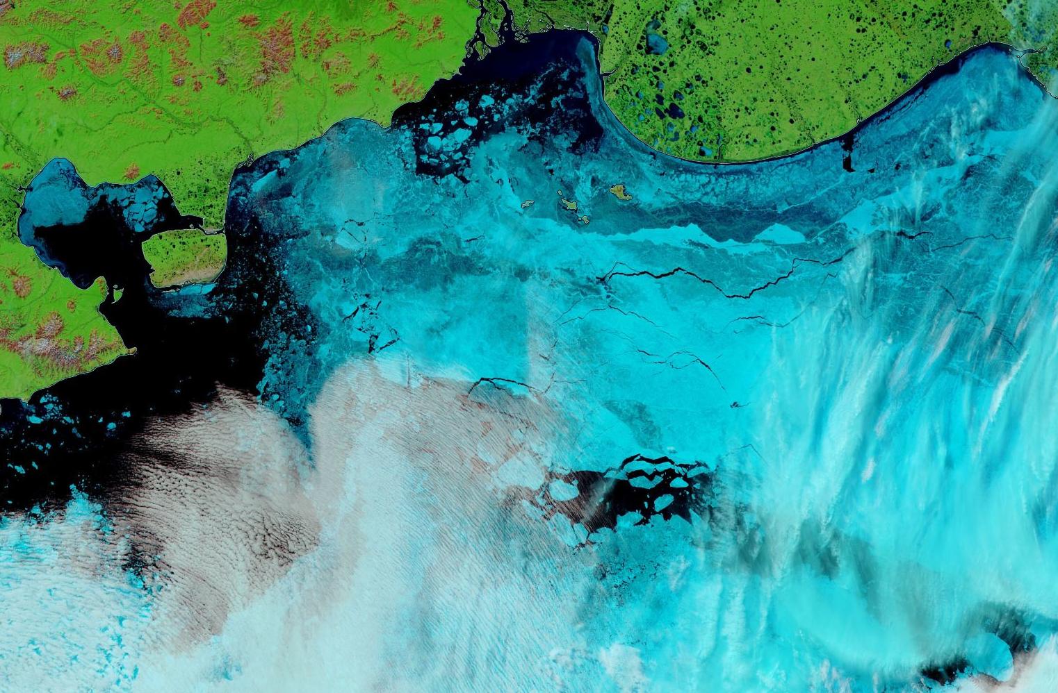
Let’s begin the month with a “true colour” image from the Terra satellite of the Laptev Sea and thereabouts:
The blueish tinge indicates the appearance of melt ponds almost everywhere over the land-fast ice currently covering the majority of the Laptev Sea.
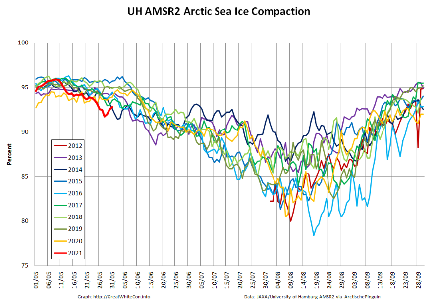
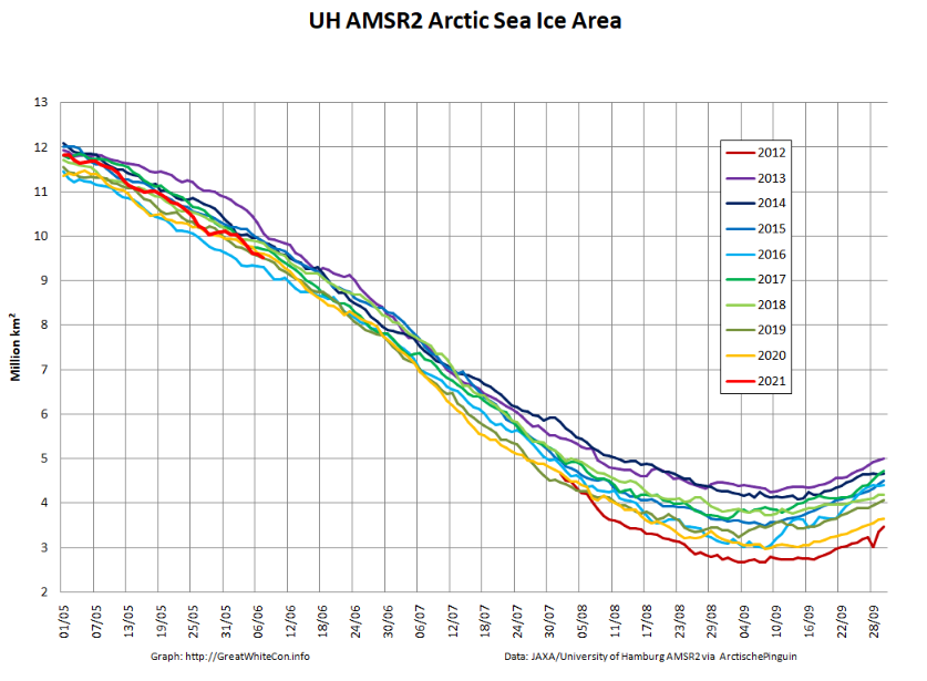
Let’s also take a look at the high resolution AMSR2 metrics for the end of May 2021:
Thanks to the recent “brief hiatus” in areal decline, Arctic wide compaction is no longer in record territory:
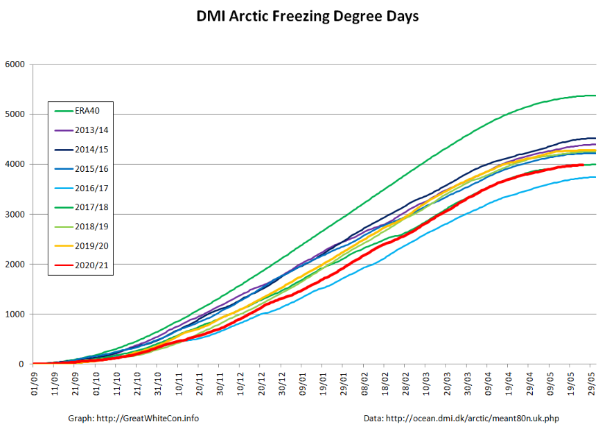
Finally, for the moment at least, here is the Danish Meteorological Institute’s high Arctic temperature data in the form of a graph of freezing degree days:
For some reason the data file still doesn’t include data to the end of May, but things won’t change much by then. Over the winter as a whole only 2016/17 was significantly warmer.
Let the 2021 Arctic sea ice summer melting season officially begin!
[Edit – June 4th]
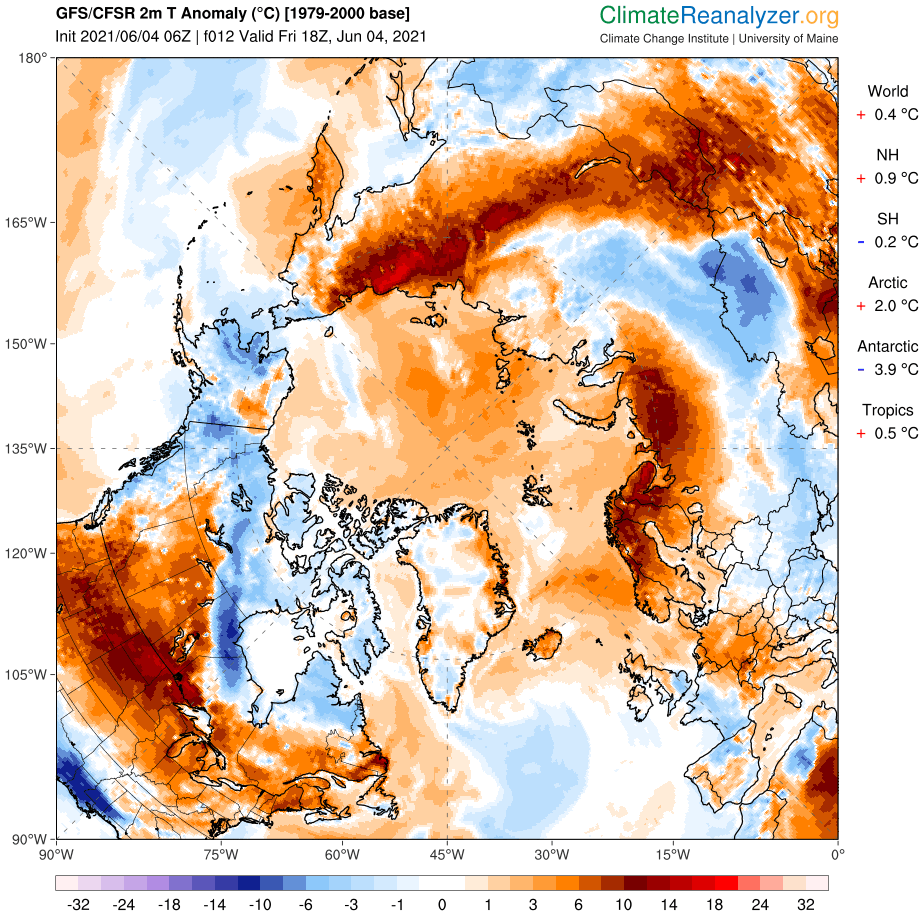
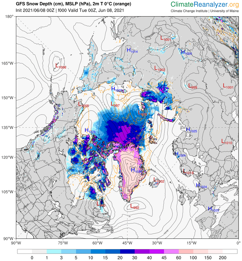
Perhaps unsurprisingly the GFS forecast from four days ago hasn’t quite worked out as predicted. The Arctic as a whole is certainly on the warm side, with a +2 C anomaly at this moment:
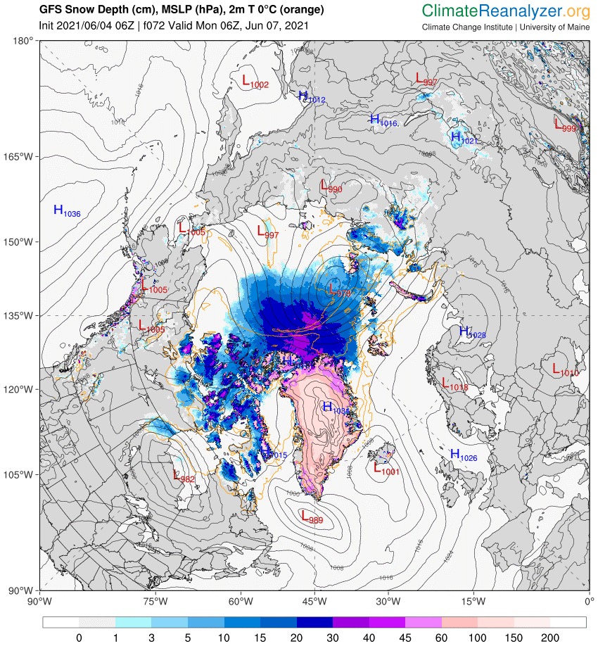
However the 966 hPa MSLP cyclone predicted for Monday is now forecast to be a mere 978 hPa:
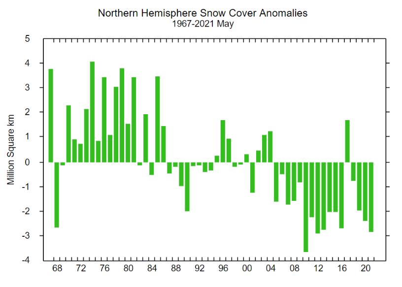
With 3 days to go there is a reasonable chance of it verifying in the “New Arctic” of 2021. As you can see from the map above a large area of the Central Arctic has now lost its snow cover. This is confirmed by the Rutgers Snow Lab northern hemisphere data for May:
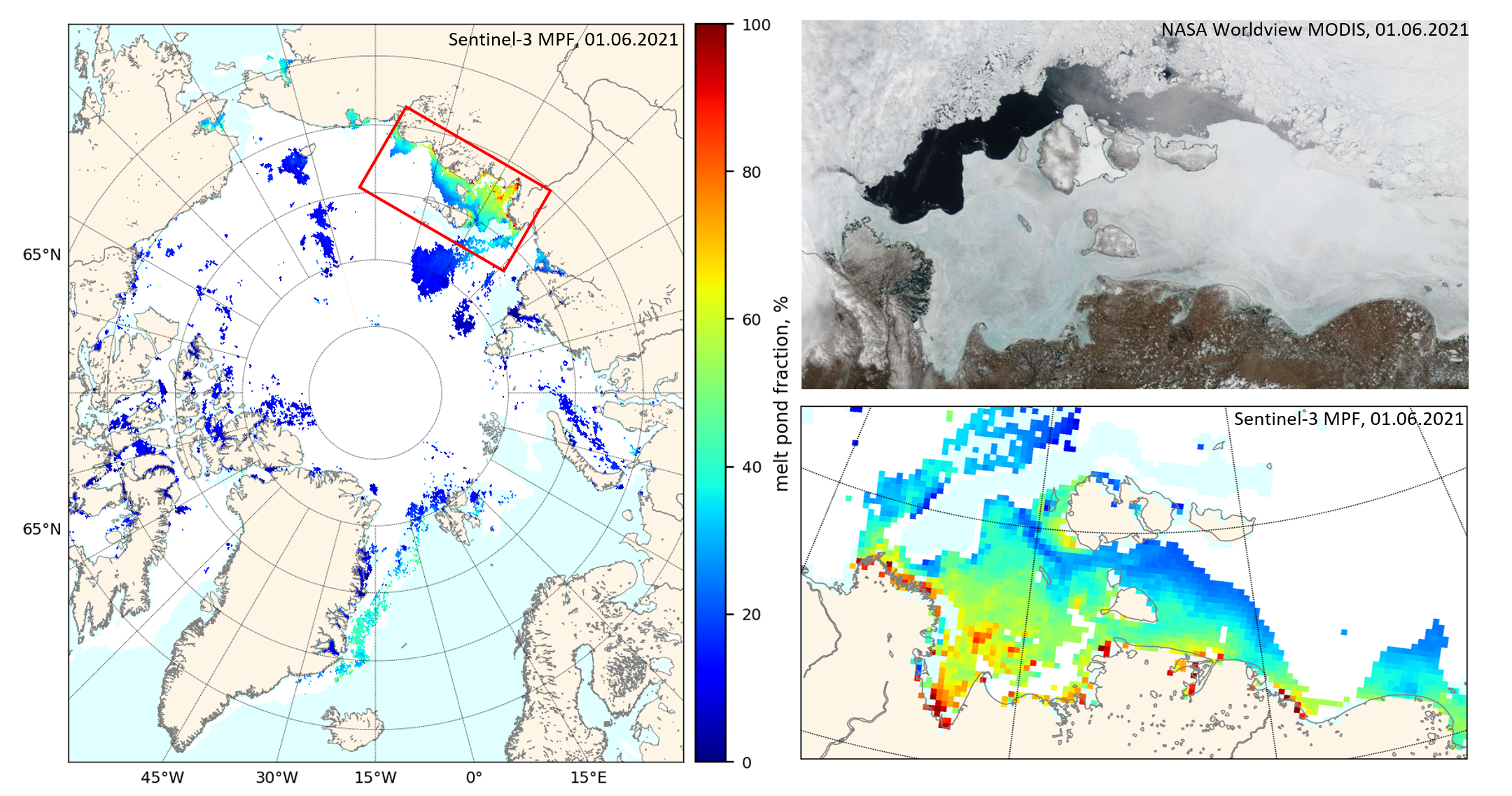
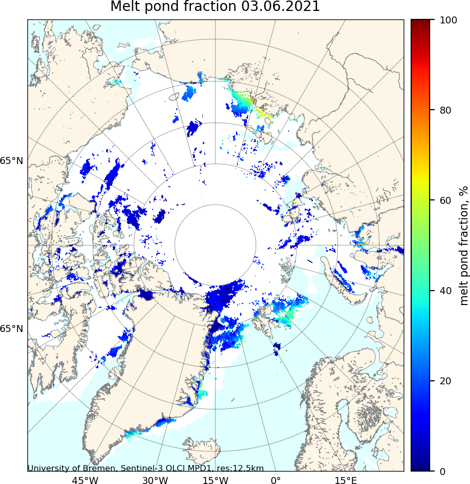
A new Sentinel 3 melt pond fraction product from the University of Bremen confirms that on the fast ice in the Laptev & East Siberian Seas snow cover has departed and melt ponds have arrived:
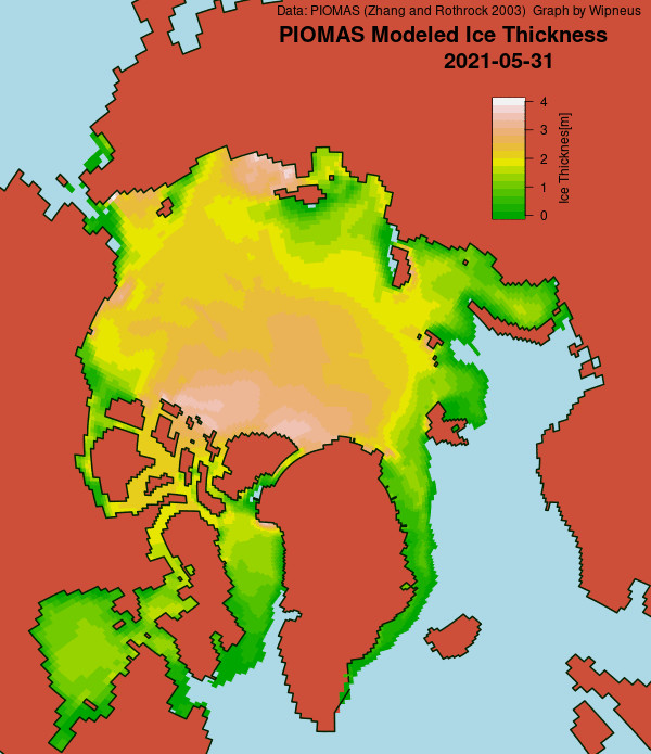
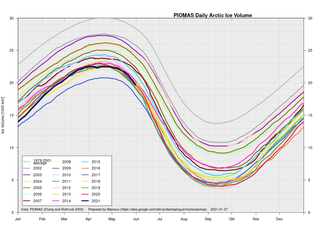
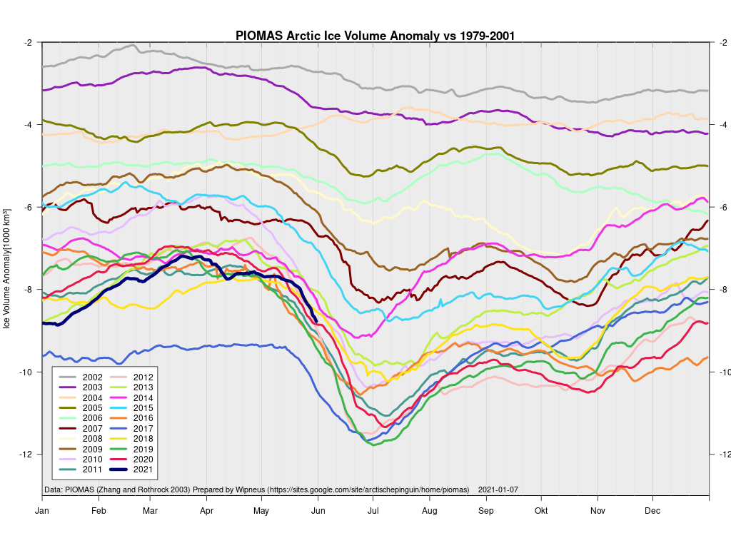
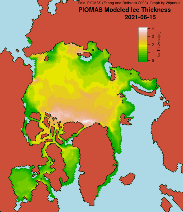
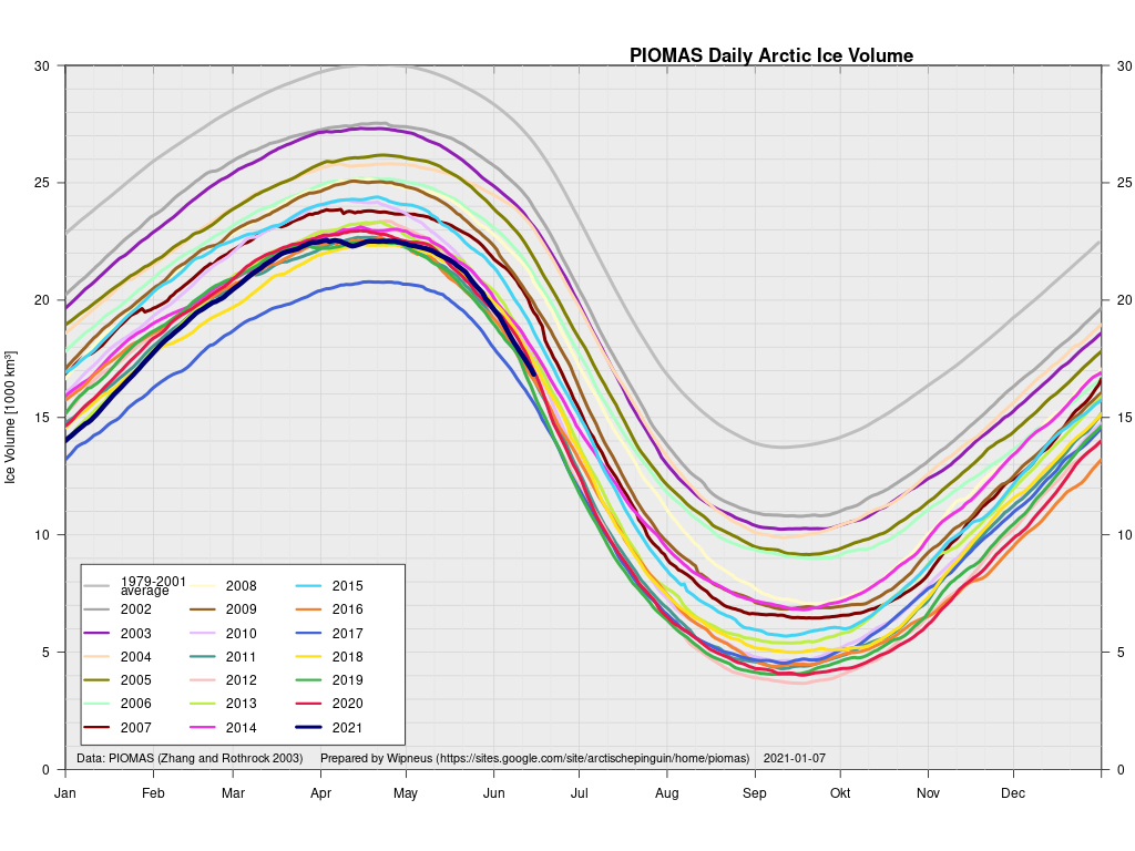
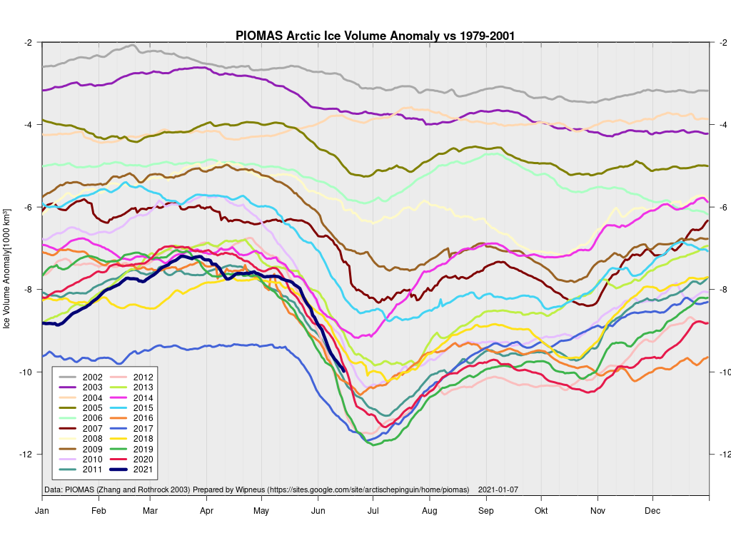
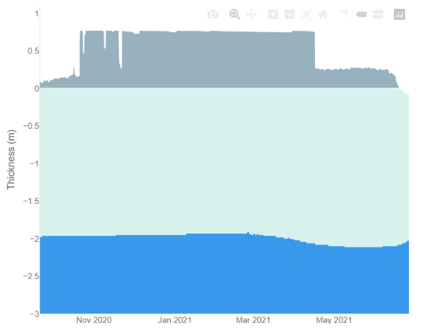
In other news Wipneus has released the latest PIOMAS gridded thickness and volume data on the Arctic Sea Ice Forum:
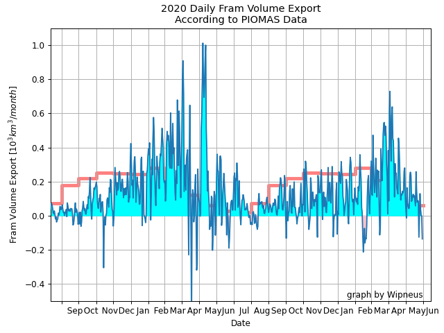
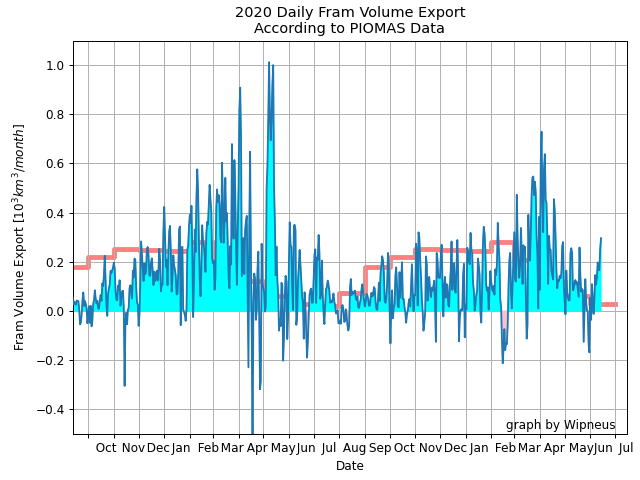
For some strange reason 2021 volume at the end of May is almost identical to 2012 and 2020! Plus of course there’s the modelled volume export from the Central Arctic via the Fram Strait:
[Edit – June 6th]
This “false colour” image reveals that there’s virtually no snow cover left on land, and this “false colour” image reveals that the land-fast ice in the East Siberian Sea is now awash with melt ponds:
[Edit – June 8th]
The forecast low pressure area appears to have bottomed out near the Severnaya Zemlya islands with a 978 hPa MSLP:
High resolution AMSR2 Arctic sea ice area is now 2nd lowest for the date after 2016:
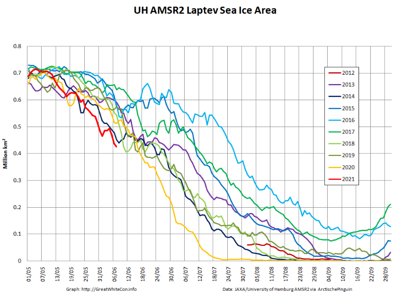
Laptev sea ice area is still lowest for the data, and looks as though it will retain that position for a while:
[Edit – June 9th]
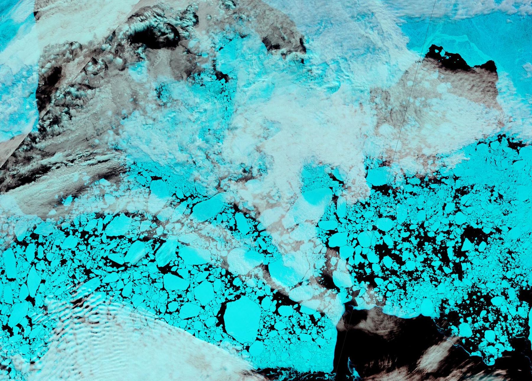
The effect of the recent heat and wind on the remaining sea ice in the Laptev Sea is now all too apparent:
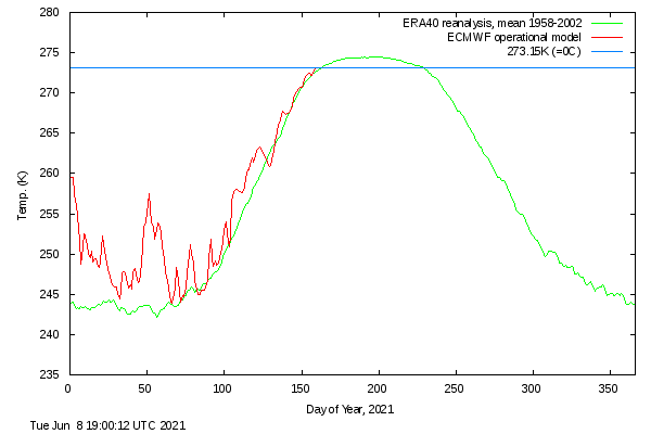
It’s also evident in the DMI >80N temperature graph, which has now reached sea ice “melting point” ahead of the climatology:
Note that the blue line is actually above the “freezing point” of salty Arctic sea water.
[Edit – June 13th]
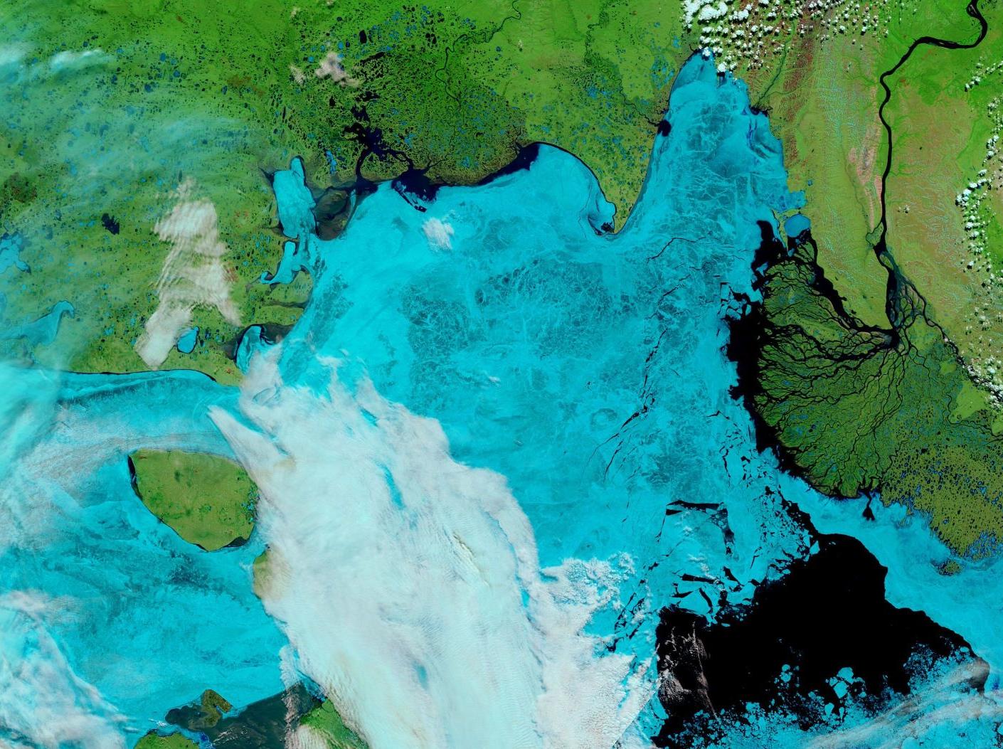
Fairly clear skies over the Laptev Sea and the western East Siberian Sea, revealing wall to wall melt ponds and the land-fast ice starting to break up near the coast as well as on the edge of the now open ocean:
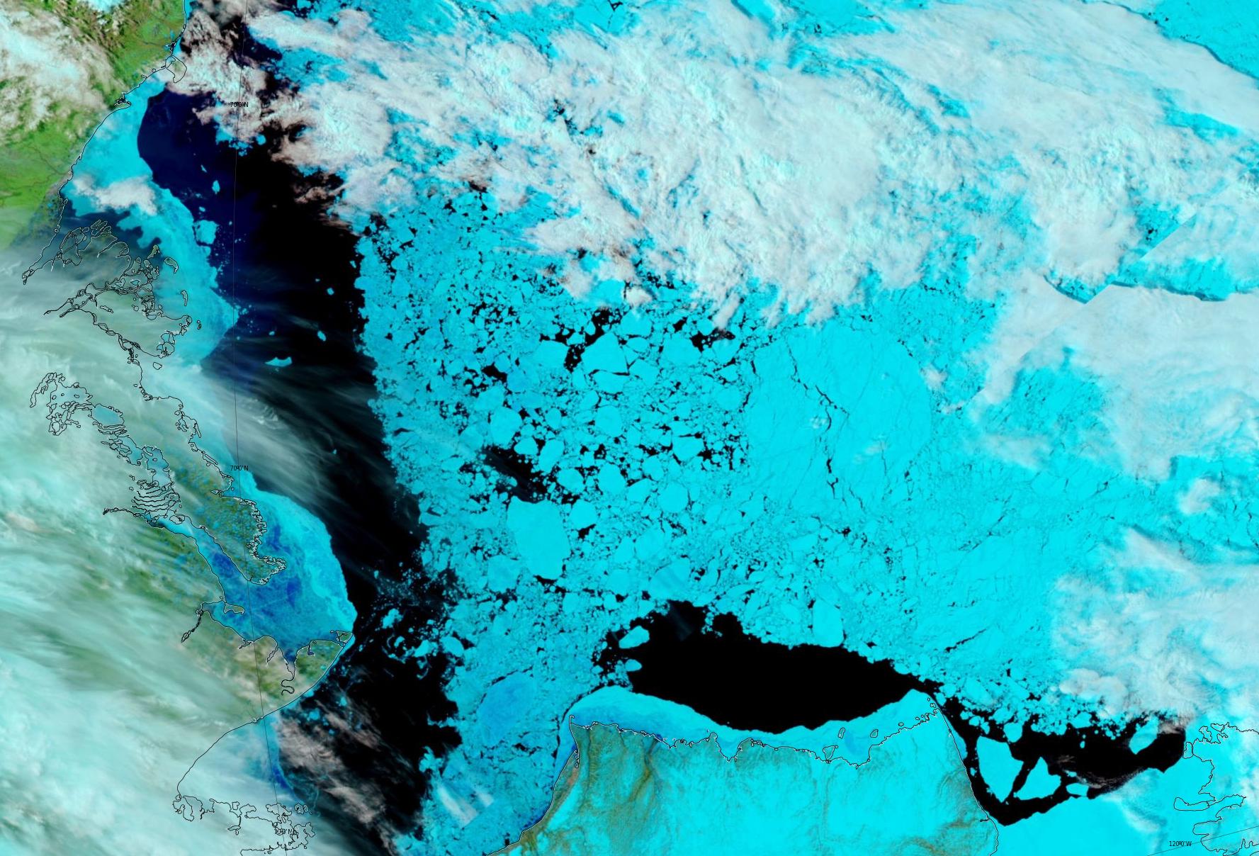
Plus yesterday’s view of the Beaufort Sea, revealing fast ice breaking up in the western entrance to the McClure Strait:
[Edit – June 18th]
A clearish view of the Laptev Sea today, revealing assorted cracks in a variety of locations:
[Edit – June 20th]
The latest mid-month PIOMAS thickness/volume numbers have been released:
[Edit – June 23rd]
The skies over the Vilkitsky Strait have been cloudy for a few days. However a fairly clear view yesterday reveals that breakup is well under way in what is usually one the last areas along the Northern Sea Route to become navigable:
[Edit – June 26th]
The land-fast ice in the East Siberian Sea has started to disintegrate en masse:
Data from ice mass balance buoy 441910, currently located at 76.1 N, 151.1 W in the Beaufort Sea, reveals the onset of both surface and bottom melt:
A reader writes to ask us to explain the answer to the above question in more detail. Are you sitting comfortably once again? Then let us begin.
There has been a lot of unusual “weather” in the Arctic over the last twelve months. First of all there was an anomalously warm winter:
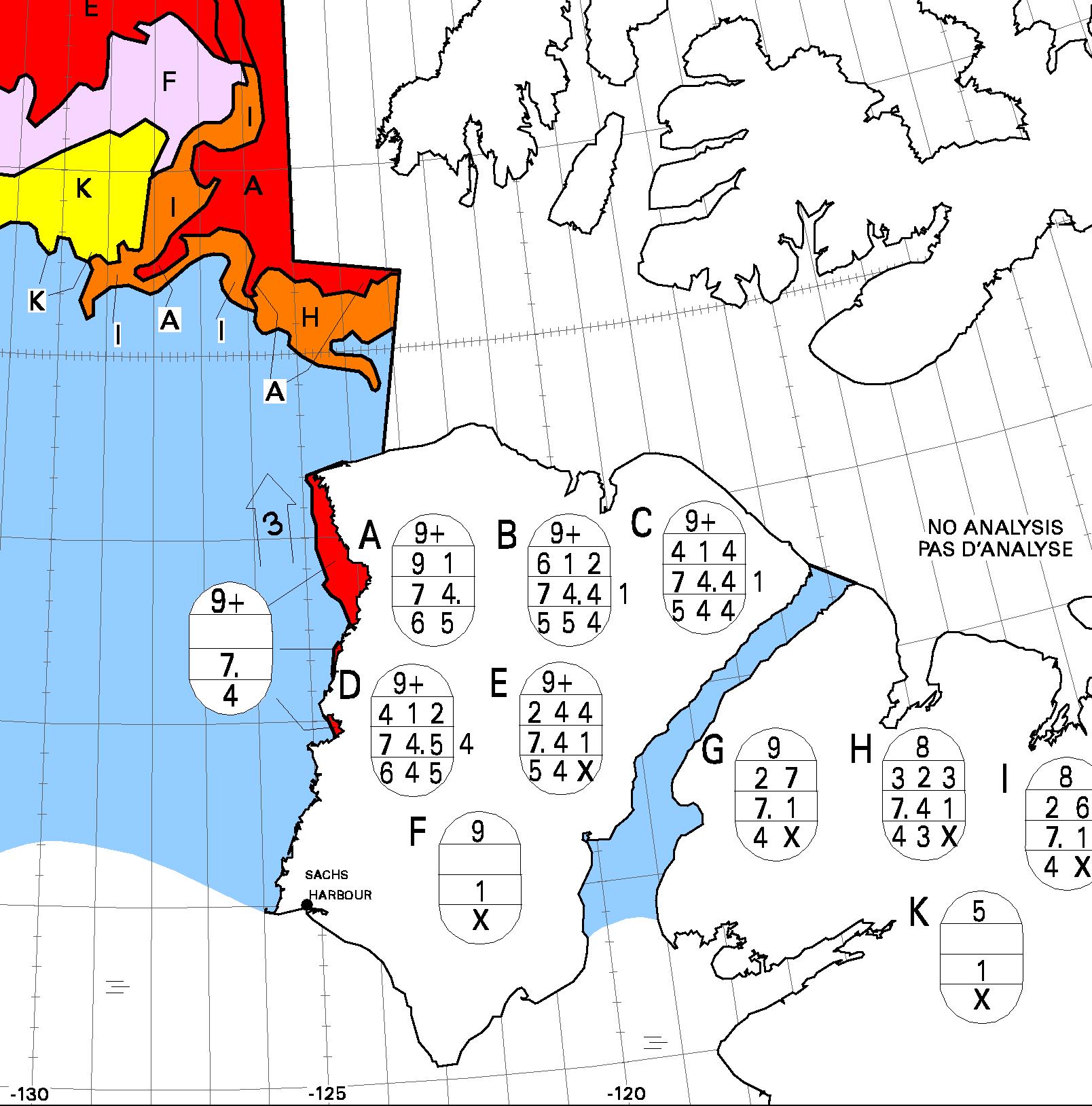
Then came what we dubbed the Great Arctic Anticyclone of 2016 in April. Take a look at what happened to the sea ice north of Alaska and Canada during the Spring and early Summer:
The ice was put through the mincer for the first time. Then during August there were a series of strong cyclones, collectively the Great Arctic Cyclone of 2016. The ice was put through the mincer once again, but in an anti-clockwise direction this time. Watch what happens in the Northwest Passage as summer turns to Autumn:
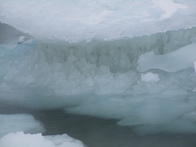
Some of the oldest, thickest ice in the Arctic has been chopped into small pieces which then easily flow through the channels of the Canadian Arctic Archipelago and into the Northwest Passage. Hence when the yacht Northabout (amongst others) was racing to reach Baffin Bay it wasn’t to avoid “the refreeze” as claimed in certain quarters. It was in fact to try and avoid the worst of the chopped up chunks of old sea ice being carried swiftly in their direction by winds and currents. Here’s what some of them looked like in close up:
The next question then becomes, if the Northwest Passage wasn’t refreezing then, is it freezing now? The answer is not yet. In fact the favourite talking point of the cryodenialista, McClure Strait at the western end of the “main” route through the Passage has recently become navigable:
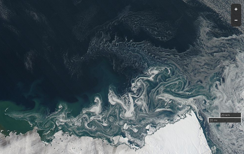
NASA Worldview “true-color” image of Banks Island on September 24th 2016, derived from the MODIS sensor on the Terra satellite
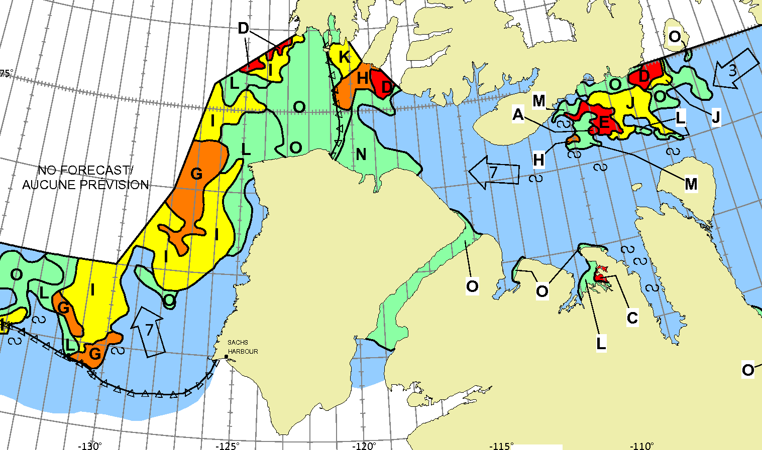
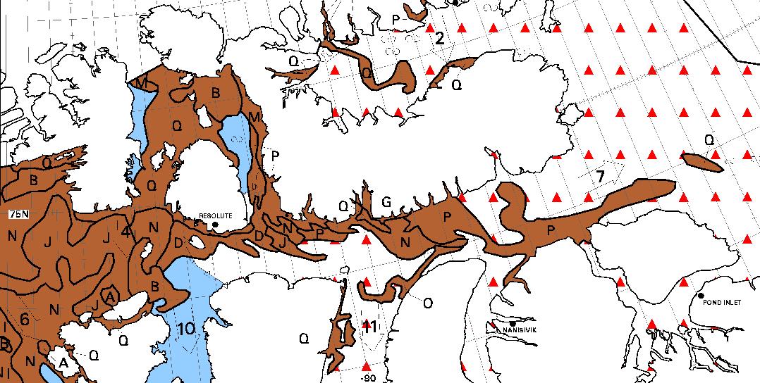
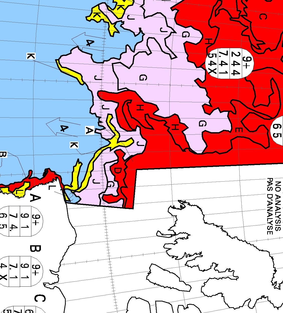
The “pretty pink” area towards the top left of the chart reveals “new ice”. The Northwest Passage will have started to refreeze when some of that shows up on a “stage of development” chart of the Passage itself, but that hasn’t happened yet. Here’s yesterday evening’s chart of the “Approaches to Resolute“:
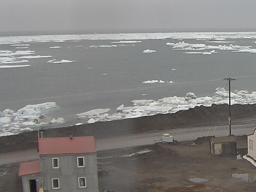
Lots of old ice! It was raining in Resolute yesterday, and the old ice there was still melting:
[Edit – September 27th]
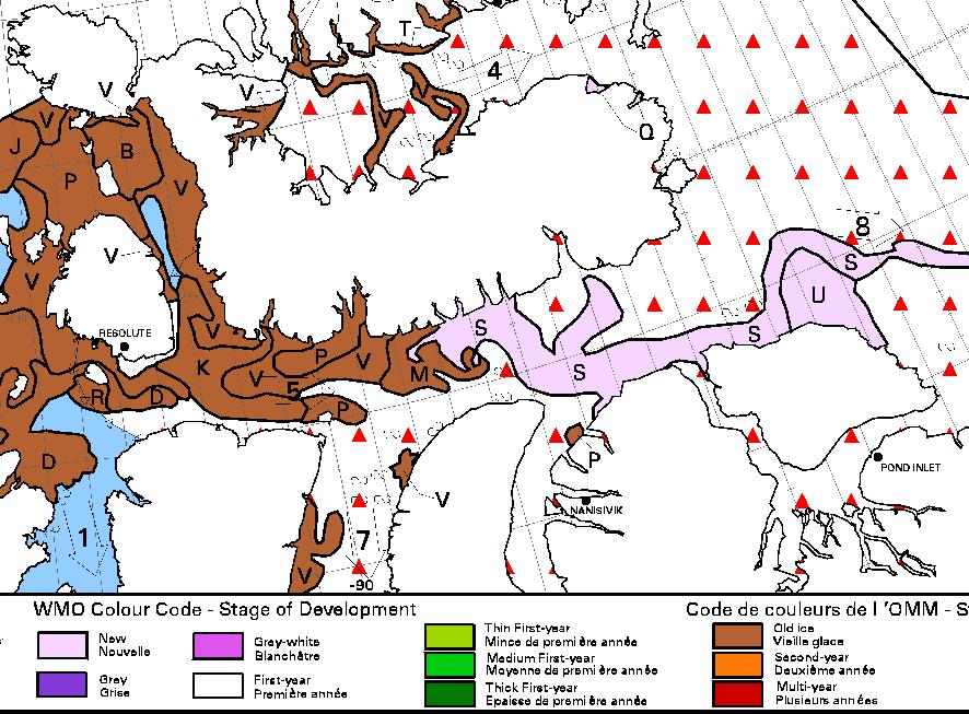
No sooner said than done! This evening’s ice charts from the CIS do now show some “pretty pink” new ice in the Northwest Passage:
The wispy areas of new ice are also visible on this “false-color” image of the Parry Channel:
NASA Worldview “false-color” image of the Parry Channel on September 27th 2016, derived from the MODIS sensor on the Terra satellite
However even if Northabout were still in Prince Regent Inlet she wouldn’t be “trapped in ice”. There is still a way back to Bristol via Fury and Hecla Strait:
A clear view of McClure Strait from the Terra satellite in “false colour”:
NASA Worldview “false-color” image of the McClure Strait on September 30th 2016, derived from the MODIS sensor on the Terra satellite
The inclusion of some infra red reveals the thicker old ice on the right noticeably paler than the new ice to its left. Compare also with the CIS ice chart, which has been rotated to match the orientation of the satellite image:
[Edit – October 2nd]
Pretty patterns in the new sea ice forming at the western entrance to McClure Strait:
NASA Worldview “true-color” image of the McClure Strait on October 1st 2016, derived from the MODIS sensor on the Aqua satellite
The freshly frozen new ice in the Northwest Passage has been spotted by the AMSR2 instrument aboard the Japanese “Shizuku” satellite:
On the latest CIS “stage of development” chart the brown “old ice” has turned to deep red “multi-year ice”, and there’s lots more pretty pink out in the Beaufort Sea:
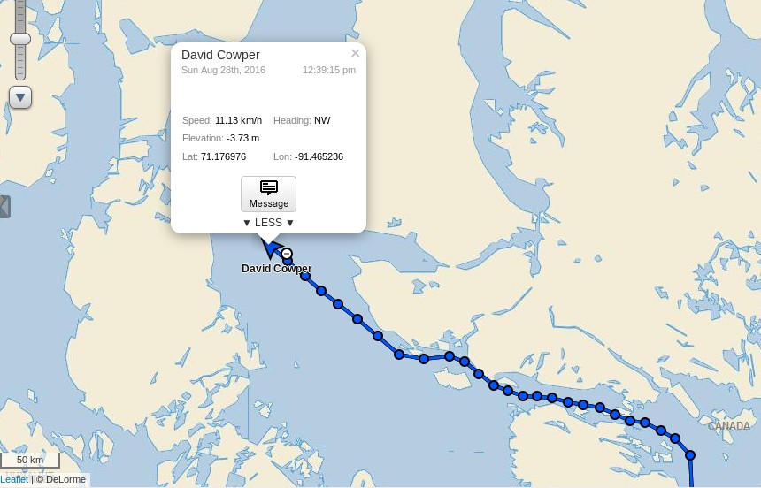
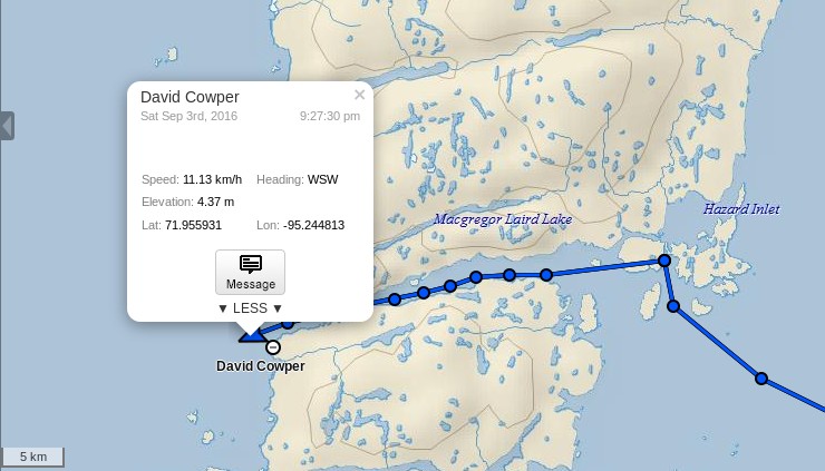
David Scott Cowper in Polar Bound is currently approaching the eastern entrance to Bellot Strait in the heart of the Northwest Passage. There’s nothing unusual in that in this day and age, you may think, but take a look at how he got there:
According to the Canadian Ice Service charts Polar Bound will only have needed to negotiate a short stretch of 1-3 tenths concentration sea ice to achieve her latest Northwest Passage “first”:
David Scott Cowper is already mentioned several times in the SPRI list of successful Northwest Passage transits:
1986-89
Mabel E. Holland (12·8 m lifeboat), Britain, David Scott Cowper, West 6, Single-handed voyage, vessel wintered at Fort Ross twice, and at Inuvik
2003-04
Polar Bound (14·6 m motorboat), Britain, David Scott Cowper, East 5, Single-handed voyage, wintered in Cambridge Bay, assisted by CCGS Louis S. St Laurent in Prince Regent Inlet
2009
Polar Bound (14·6 m motorboat), Britain, David Scott Cowper, West 5, Single-handed voyage
2011
PolarBound (14·6 m motorboat), Britain, David Scott Cowper, East 3
2012
PolarBound (14·6 m motorboat), Britain, David Scott Cowper, West 1
2013
PolarBound (14·6 m motorboat), Britain, David Scott Cowper, East 5, Traversed Pond Inlet
It looks as though there will be another addition real soon now, but for the moment note in particular the entry for 2012. Route 1 is the northernmost of the potential paths through the Northwest Passage and involves negotiating the usually ice bound McClure Strait. Polar Bound was the first ever small vessel to do so! At the moment it looks like that will be a difficult feat to repeat this year. Whilst many of the assorted channels through the Northwest Passage melted out early this year the recent recurring cyclones have ensured that McClure Strait remains firmly blocked:
[Edit – September 3rd]
Polar Bound has just emerged from the western end of Bellot Strait:
The $64,000 question is where is she headed next?
[Edit – September 4th]
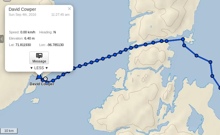
The short term answer is a sheltered spot between Hobday Island and Prince of Wales Island:
[Edit – September 7th]
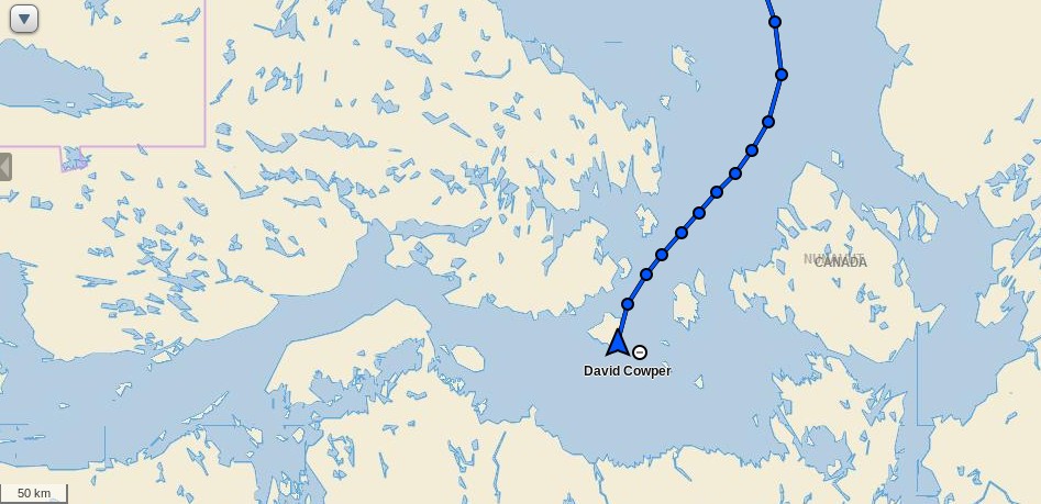
Polar Bound is taking the most obvious exit from the Canadian Arctic Archipelago, and is currently heading for Coronation Gulf via Dease Strait:
David Scott Cowper is currently approaching Barrow in Polar Bound, but the weather forecast is more than a bit blustery. According to today’s National Weather Service forecast, here’s what he should expect:
POINT FRANKLIN TO CAPE HALKETT-
405 AM AKDT SAT SEP 17 2016
…SMALL CRAFT ADVISORY IN EFFECT FROM LATE THIS MORNING THROUGH
EARLY SUNDAY MORNING…
TODAY
SW WINDS 25 KT. SEAS BUILDING TO 5 FT. SNOW AND RAIN.
TONIGHT
W WINDS 30 KT. SEAS 9 FT. FREEZING SPRAY.
SUN
W WINDS 30 KT. SEAS 10 FT. FREEZING SPRAY.
SUN NIGHT
W WINDS 30 KT. SEAS 11 FT.
Let’s hope Polar Bound finds some shelter before the worst of it arrives on Sunday night.
[Edit – September 21st]
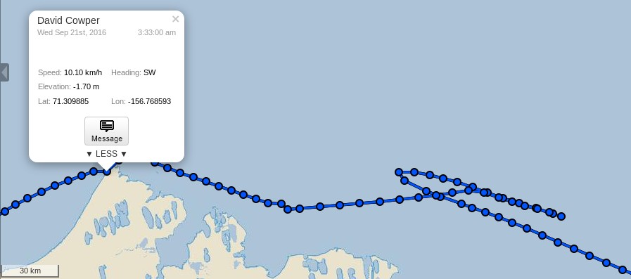
It seems Polar Bound didn’t find shelter, and instead reversed course during the worst of the storm:
However, as you can see, she has now passed Point Barrow and is Heading south towards the Arctic Circle via the Bering Strait:
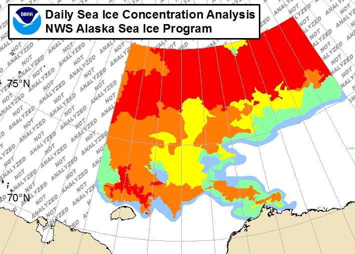
Can you spot the yellow needle in the icy haystack? There is currently much “debate” in the cryodeinialosphere to the effect that Northabout nearly became “trapped by ice”, so let’s also take a quick look at the National Weather Service ice chart covering Barrow shall we?
It seems Polar Bound somehow managed to wend her way through 7-8/10 concentration sea ice, does it not?
[Edit – September 24th]
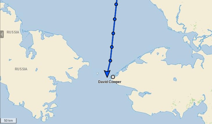
Polar Bound has now crossed the Arctic Circle and is heading south through the Bering Strait:
David Scott Cowper has therefore now “officially” completed his record breaking route West 7 transit of the Northwest Passage.
Our coverage of the Northwest Passage is starting somewhat earlier then usual in 2016. That’s because an educational comment of mine seems to have gone permanently missing over at Andrew Montford’s blog. Over there commenter “Golf Charlie” suggested that:
Perhaps based on rumours, or folk stories, the possibility of a North West Passage, was the answer to many peoples dreams of wealth, fame and fortune. The Franklin Expedition set off, with all confidence, knowing that there had been an unprecedented retreat in Arctic sea ice extent. They never came home. The ships then sent to rescue them, never came home either, but some survivors did.
In July 2010, due to unprecedented ice loss, a team set out to find HMS Investigator, (one of the rescue ships) and found her within 15 minutes, exactly where she was trapped and abandoned. How had she got there?
This may be just a load of boring and irrelevant history to you, but as an ice expert keen to lecture others, it just seems strange that you don’t acknowledge the fact that before man made CO2 emissions could possibly had any remote chance of shrinking sea ice, it had all happened before.
It is likely that whatever caused the ice to retreat in the 1830s/40s, may have caused the current retreat. As no attempt has been made to explain this historical retreat, it seems premature to jump to conclusions about the present. What stories and folklore convinced Franklin there was a NWP? Had it opened before? Did the Vikings circumnavigate the North Pole? No one knows for sure.
Here’s the beginnings of my by now expanded reply:
I am already very familiar with the sorry tale of Franklin’s ill fated expedition. By way of some more recent Northwest Passage history, were you previously aware that Charles Hedrich completed his own multi-year voyage through the NWP last summer? His vessel was much smaller than Franklin’s:
“He is now, the first man to have rowed solo the North-West Passage.”
It’s not terribly clear, but apparently Charlie thinks his “unprecedented ice loss” in the Summer of 2010 had a precedent in the 1840s and/or 50s. Perhaps he will pop in and elucidate? Whilst we wait to see what transpires in that regard, here’s an animation of sea ice concentration across the Northwest Passage last summer:
My missing comment also referenced (by way of example!) a 2015 academic journal paper entitled “Ice thickness in the Northwest Passage“. Amongst its other conclusions can be found this:
Global climate models with their coarse resolution likely have difficulty capturing intricate sea ice dynamic processes within the narrow channels of the CAA. Specifically, the import, survival, and thickness of MYI are difficult to predict and may in fact increase during the transition to a sea ice-free Arctic with more mobile ice conditions in the Queen Elizabeth Islands which are located between the Arctic Ocean and NWP. Presumably, MYI from the Arctic Ocean will be more heavily ridged and thicker than locally formed MYI, posing greater danger to transiting ships than locally grown MYI.
Whilst we look forward to the prospects of the “transition to a sea ice-free Arctic”, what about the prospects for the Northwest Passage in the summer of 2016. As you can see from the video there wasn’t much in the way of multi-year sea ice left there by the Autumn of 2015, and there doesn’t seem to have been much transport of ice into the Canadian Arctic Archipelago over the winter either.
On top of the ice there will of course be some snow by now. Here’s how the Topaz 4 snow cover map of the area looks at the moment:
All in all it looks to me at this early stage of the 2016 Arctic sea ice melting season as though one or more of the assorted routes through the Northwest Passage will be open again this coming summer. Do you suppose that will look like yet another “unprecedented retreat” to “Golf Charlie’s” eyes?
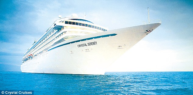
It seems as though a large commercial organisation sees things that way too. Crystal Cruises have concluded that in 2016 the Northwest Passage offers:
The ultimate expedition for the true explorer!
Anchorage to New York on Crystal Serenity
DATES : August 16 – September 17, 2016 (32 Days) CRUISE-ONLY FARES FROM : $21,855 Per Person
More than 18 months of careful planning and analysis has already gone into this project from January 2013 to July 2014, and will continue up to, and through, departure.
There will not be shore-based cell phone signals along the transit, except in the communities and towns we will be visiting. However, guests are requested to not use this signal when in port, as it will overwhelm the local system and disrupt the communication within the community.
While communication channels may be temporarily limited or unavailable to guests, the ship’s Captain and crew will always have operational and emergency communication throughout the entire voyage.
This website uses cookies to improve your experience. We'll assume you're ok with this, but you can opt-out if you wish. Cookie settingsACCEPT
Privacy & Cookies Policy
Privacy Overview
This website uses cookies to improve your experience while you navigate through the website. Out of these, the cookies that are categorized as necessary are stored on your browser as they are essential for the working of basic functionalities of the website. We also use third-party cookies that help us analyze and understand how you use this website. These cookies will be stored in your browser only with your consent. You also have the option to opt-out of these cookies. But opting out of some of these cookies may affect your browsing experience.
Necessary cookies are absolutely essential for the website to function properly. This category only includes cookies that ensures basic functionalities and security features of the website. These cookies do not store any personal information.
Any cookies that may not be particularly necessary for the website to function and is used specifically to collect user personal data via analytics, ads, other embedded contents are termed as non-necessary cookies. It is mandatory to procure user consent prior to running these cookies on your website.