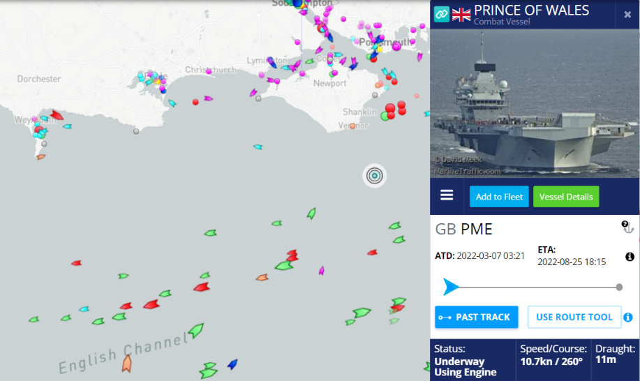
In a press release earlier today the Royal Navy announced that:
The UK’s largest warship has left Portsmouth to lead a NATO task force to the Arctic for the biggest exercises in Norway for 30 years.
Aircraft carrier HMS Prince of Wales deploys in her role as NATO’s command ship to Exercise Cold Response, the large-scale Norwegian-led exercises which will see 35,000 troops from 28 nations operate together in the harshest environment.
Prince of Wales is responsible for leading NATO’s Maritime High Readiness Force – an international task group formed to deal with major global events – and deploys for the first time in that role to Cold Response.
Aboard the carrier are the most senior sea-going staff in the Royal Navy – Commander UK Strike Force, headed by Rear Admiral Mike Utley, who will lead a sizeable task force as part of a galvanized NATO effort for peace and stability in Europe.
Rear Admiral Utley said: “NATO is the cornerstone of the UK defence and our commitment to the alliance is absolute.
“It is a privilege to be the UK Maritime Component Commander as we participate in this Norwegian-led exercise.”
Prince of Wales will be at the head of a powerful maritime task force, which, alongside aircraft and land forces – including Royal Marines Commandos – will show how a unified multilateral force would defend Norway and Europe’s northern flank from a modern adversary.
Around the aircraft carrier will be a protective ring of steel made up of warships, aircraft, a nuclear-powered attack submarine and a Royal Fleet Auxiliary replenishment vessel. Together they will defend Prince of Wales against threats above, below and on the waves throughout her high north deployment.
It will be the first time one of the Royal Navy’s new Queen Elizabeth-class carriers has operated in the Arctic and it is a challenge the ship’s company is relishing.
As of 4 March 2022, a total of 27 nations and some 30,000 soldiers are signed up for Cold Response. These numbers are likely to change as we get closer to the exercise.
The 30,000 participants consist of: • 14,000 land forces • 8,000 naval forces • 8,000 air forces and staff
About 220 aircraft and more than 50 vessels will take part in the exercise.
In addition to military units from NATO, partner nations and the Norwegian Armed Forces, a number of Norwegian civilian agencies and organisations will also take part. In addition to this, 39 Norwegian municipalities are involved in the exercise.
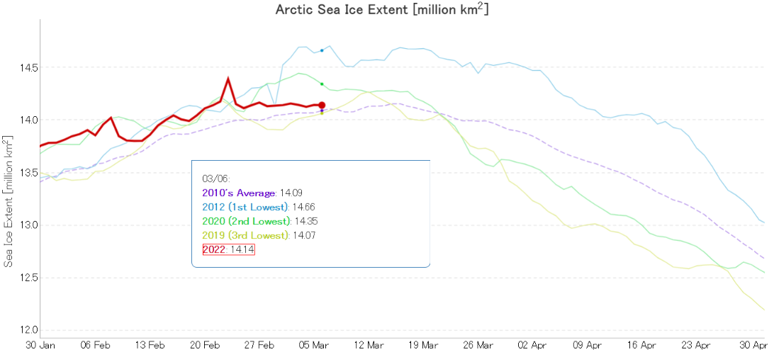
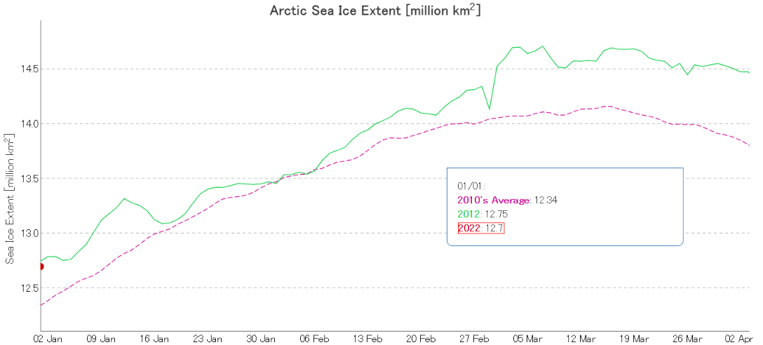
For detailed analysis of Arctic sea ice extent over the next few weeks please see the 2022 maximum extent thread. However to get the new open thread going here is the current JAXA/ViSHOP extent graph:
It’s looking more and more as though the real maximum for 2022 occurred close the false peak on February 23rd.
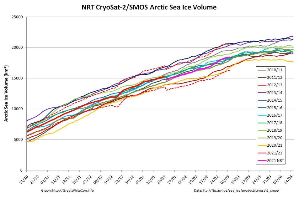
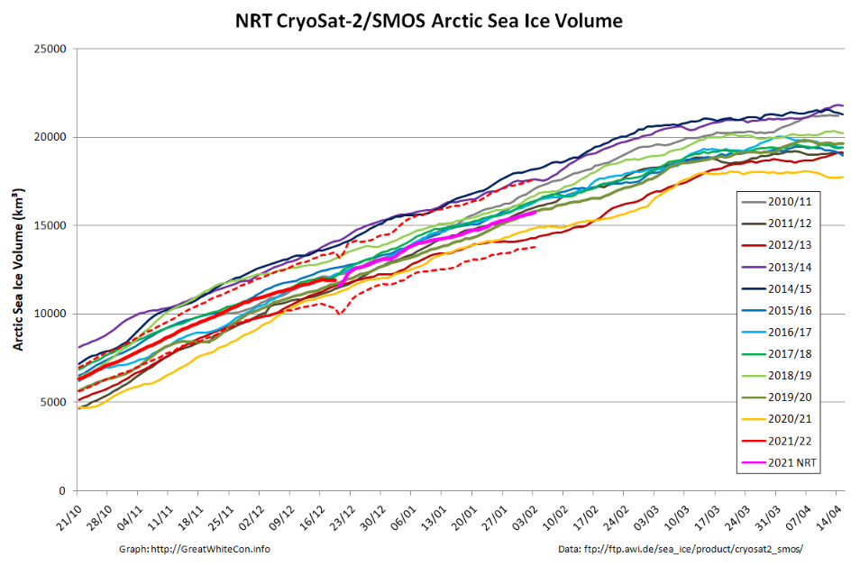
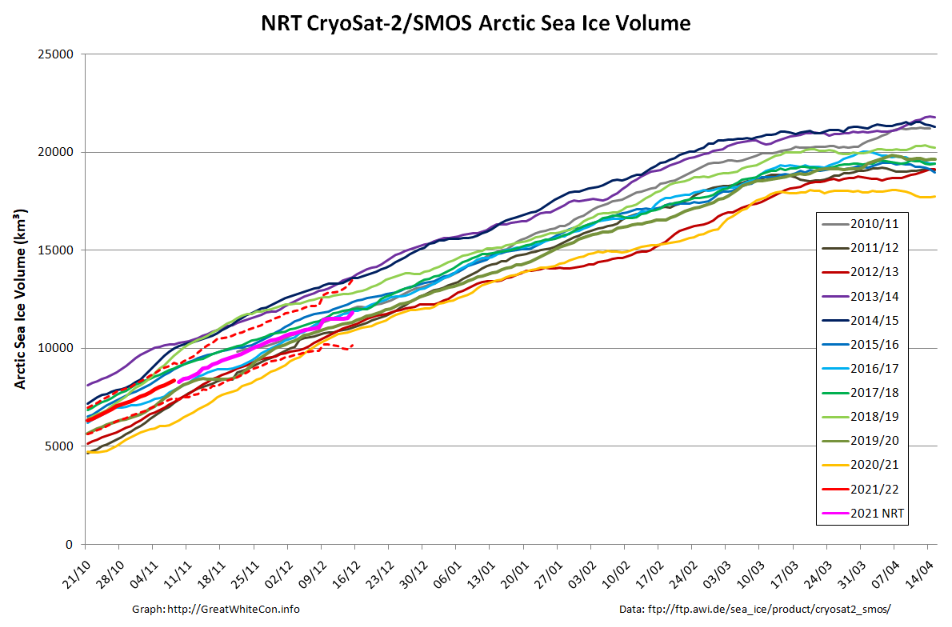
Arctic sea ice volume will keep increasing for a while longer. Here is the current AWI CryoSat-2/SMOS volume graph:
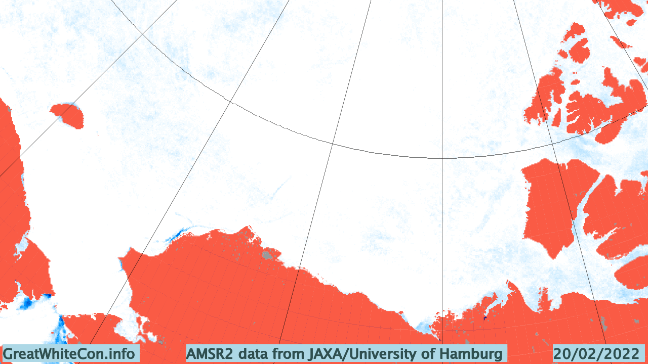
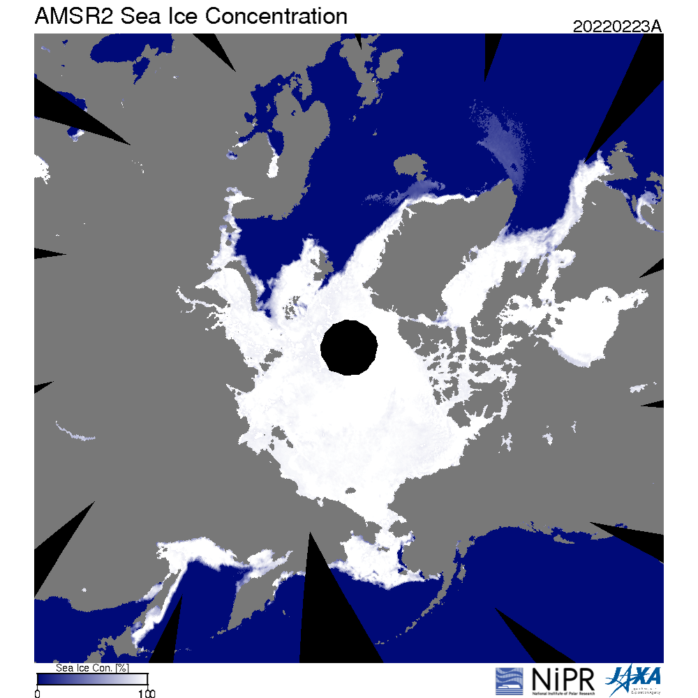
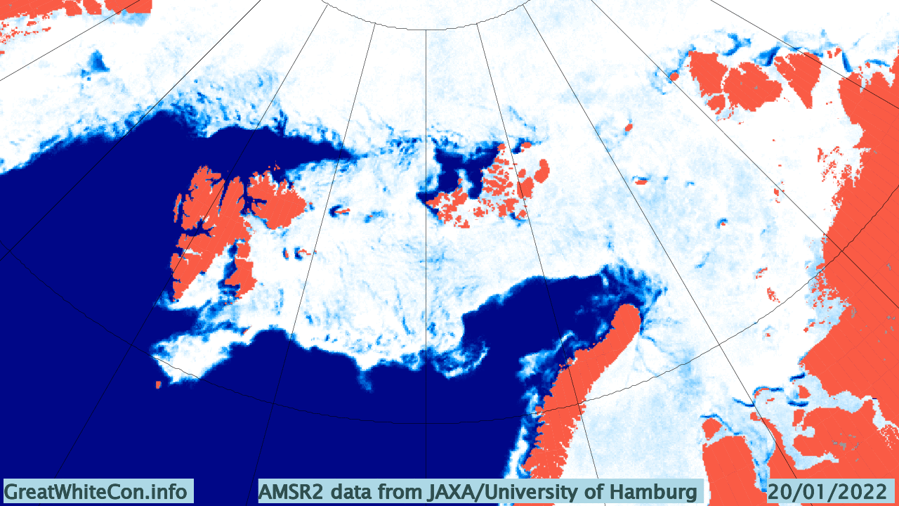
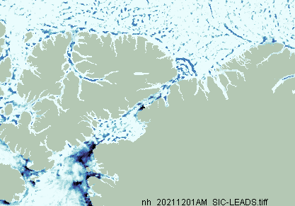
The recent “flat line” in extent is in part due to recent events on the Pacific periphery of the Arctic. Take a look at this animation of AMSR2 sea ice concentration:
The gap varies depending on how the wind blows, but there is still evidence of open water (or very thin ice) along the shore of the Beaufort and Chukchi Seas. Here’s the Mackenzie Delta and the adjacent Beaufort Sea on March 5th:
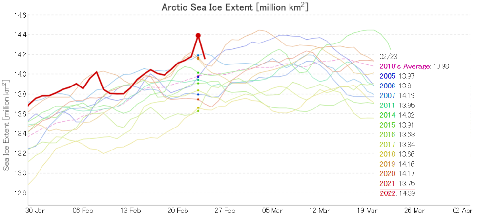
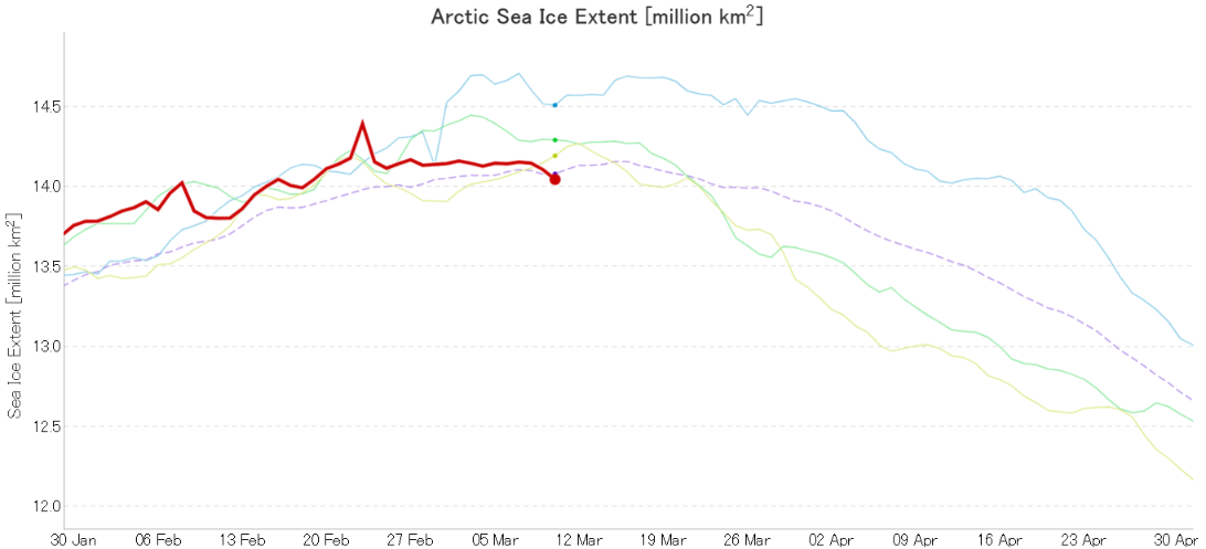
Here’s the latest graph of Arctic sea ice extent from JAXA/ViSHOP, which looks a bit unusual to say the least:
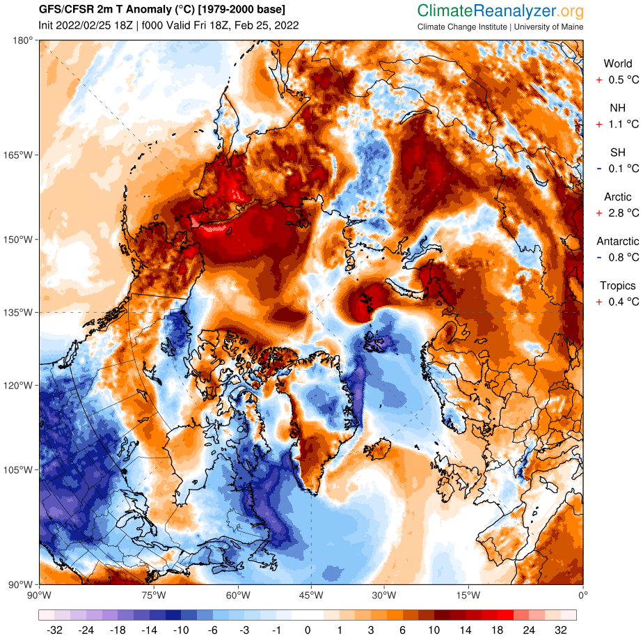
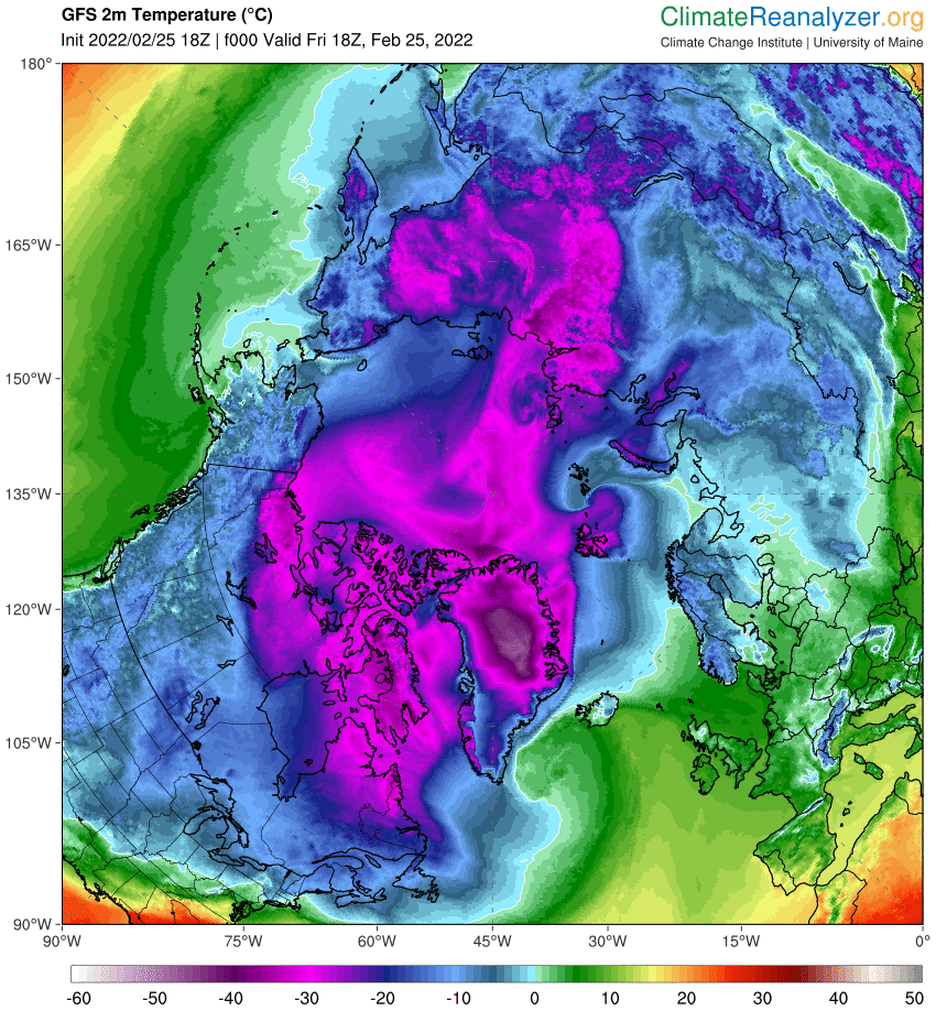
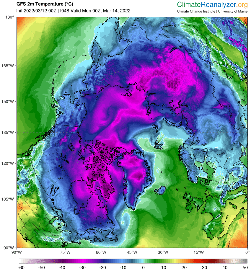
It certainly caught my eye! Could that sudden peak on February 23rd be the maximum extent for the year? To be frank it looks more like an artifact in the underlying gridded AMSR2 concentration data, but it’s not wholly beyond the bounds of possibility. The Pacific side of the Arctic is anomalously warm at the moment:
and parts of the Bering Sea are above freezing point:
For the moment then the (extremely!) provisional JAXA Arctic sea ice maximum extent for 2022 is 14.39 million km².
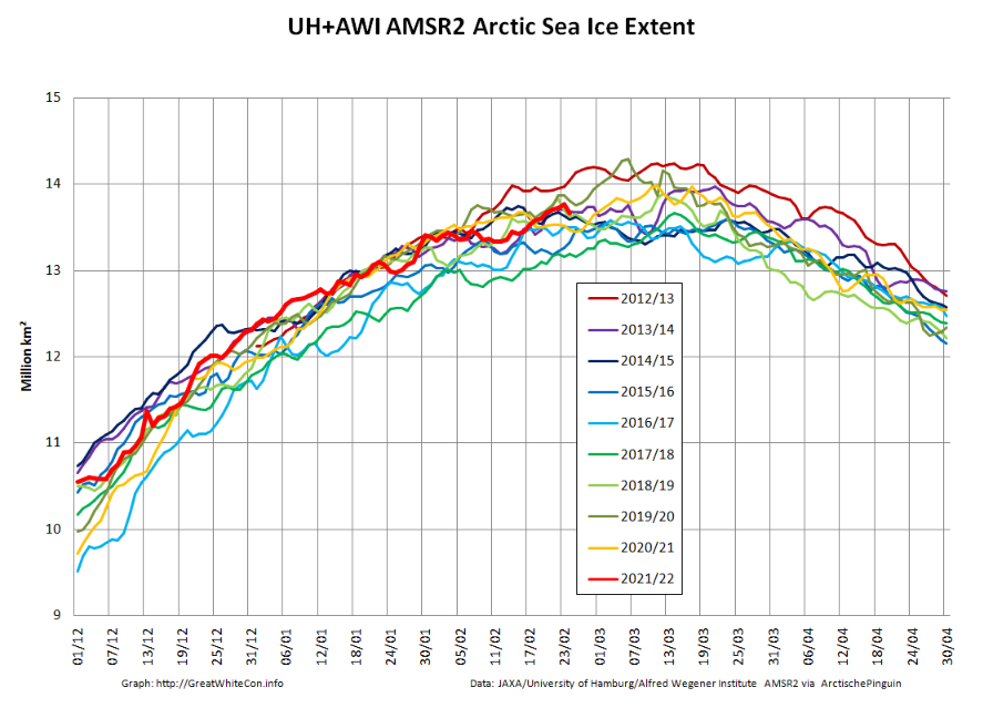
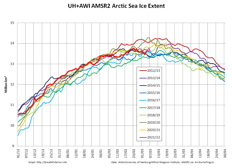
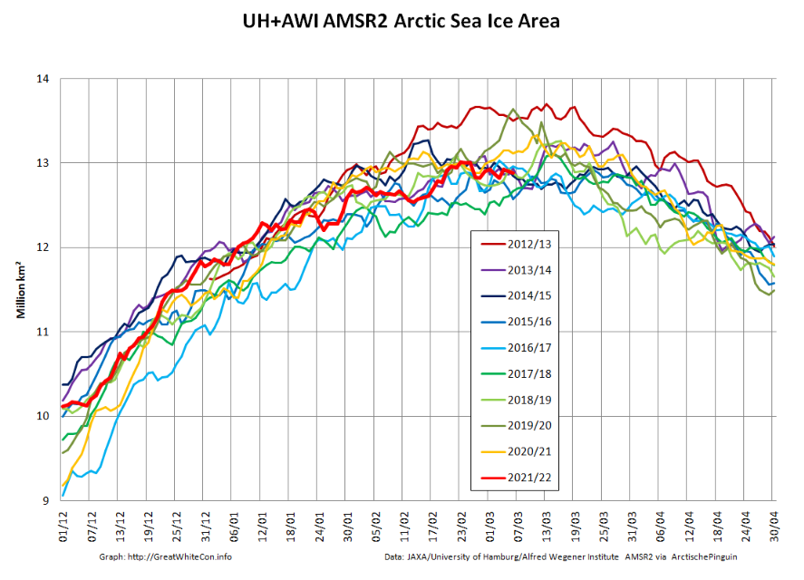
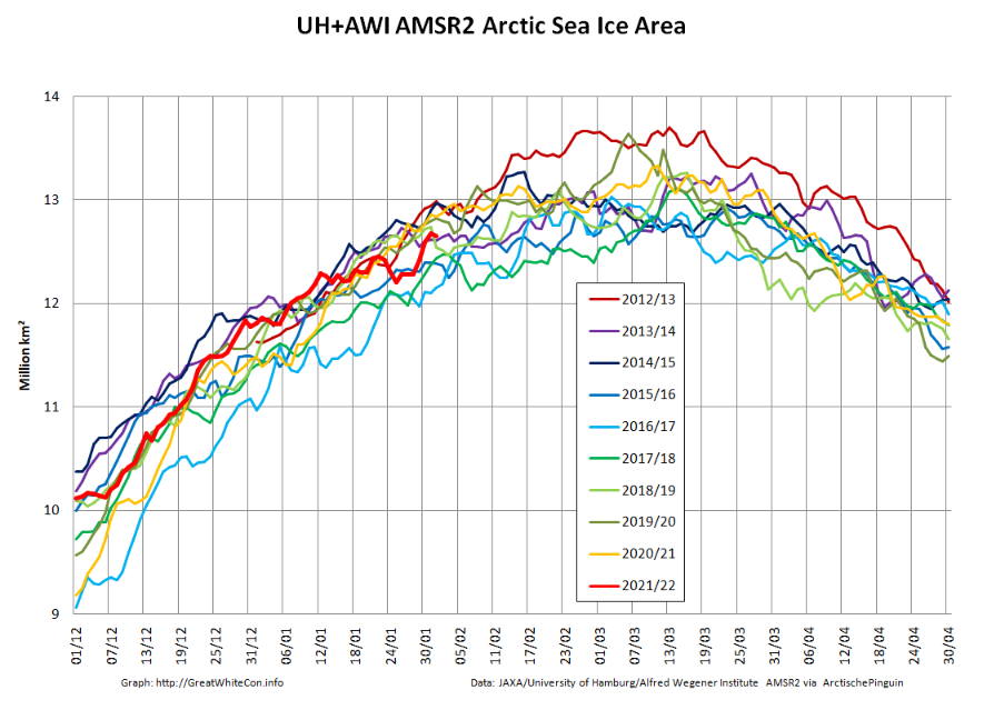
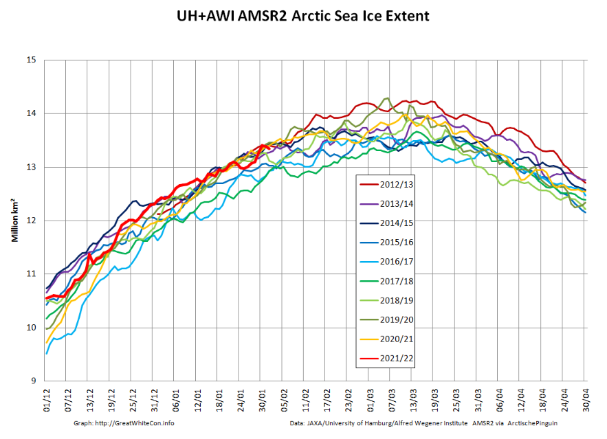
By way of an AMSR2 second opinion let’s also take a look at our favourite “high resolution” AMSR2 metrics, which combine recent data from the Alfred Wegener Institute with historical data from the University of Hamburg:
The extent peak on the 23rd is of much smaller magnitude, and it’s almost non existent on the area graph.
Curiouser and curiouser.
[Edit – March 1st]
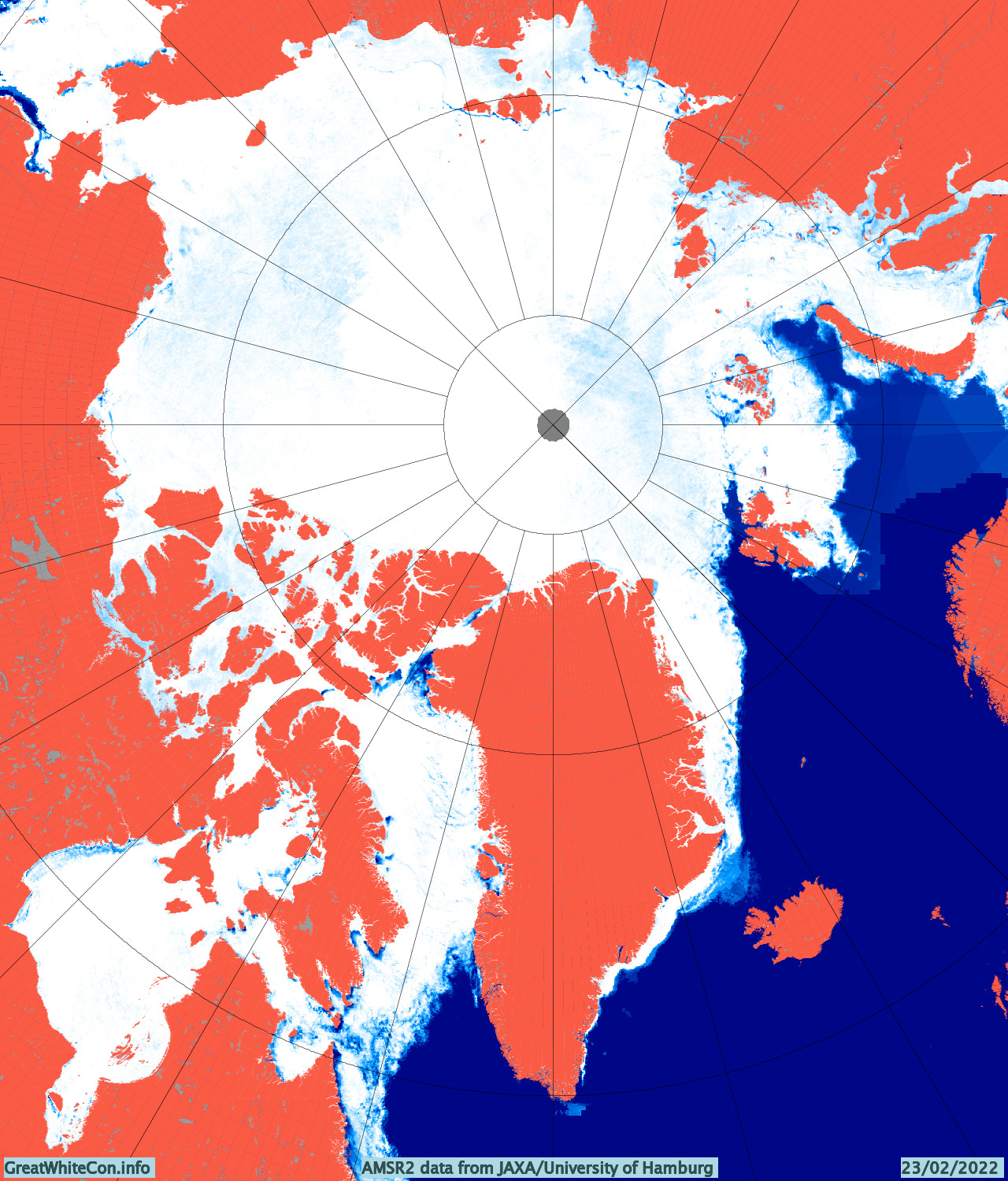
The JAXA maximum on February 23rd is definitely an artifact of dodgy AMSR2 data. Take a look at the Denmark Strait between Greenland and Iceland in particular:
The University of Hamburg version also shows an anomaly in the Barents Sea:
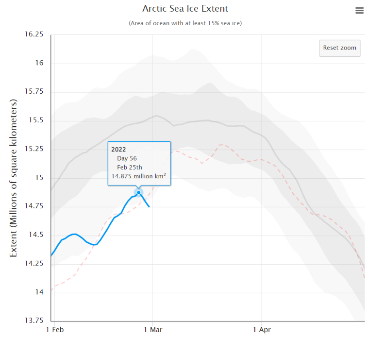
However the 5 day averaged NSIDC extent graph now shows a significant peak on February 25th:
Is anybody willing to put money on 14.875 million km² just yet?
[Edit – March 7th]
Here are the latest “high resolution” AMSR2 graphs:
The February 23rd maximum holds, for the moment at least.
[Edit – March 11th]
Here’s the latest JAXA Arctic sea ice extent graph:
A late surge is now looking exceedingly unlikely. However given that the maximum seems to have occurred during the brief period of dodgy data around February 23rd, what magnitude and date should be assigned to the 2022 maximum?
Whilst I ponder that thorny problem…
[Edit – March 12th]
Now I’ve really gone and done it! Started the “2022 melting season” thread on the Arctic Sea Ice Forum that is:
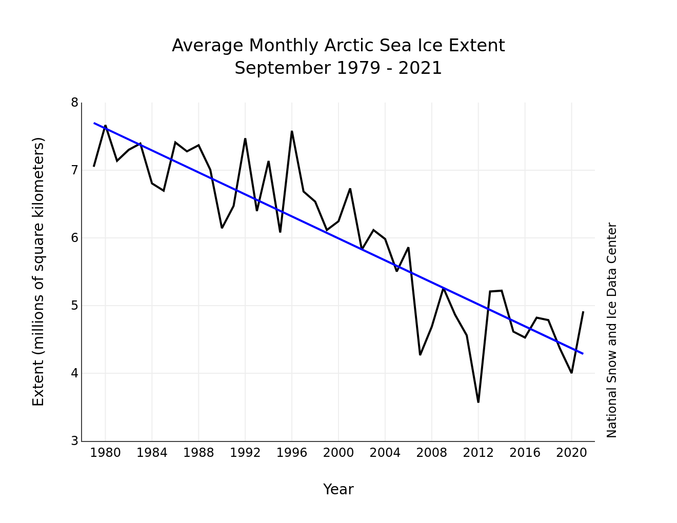
Arctic sea ice has likely reached its maximum extent for the year, at 14.88 million square kilometers (5.75 million square miles) on February 25. The 2022 maximum is the tenth lowest in the 44-year satellite record. On the same day, on the other pole, Antarctic sea ice reached a record minimum extent, at 1.92 million square kilometers (741,000 square miles).
The date of the maximum this year, February 25, was fifteen days earlier than the 1981 to 2010 average date of March 12. Only two years had an earlier maximum, 1987 and 1996, both on February 24. This year is the second earliest date on the satellite record, tying with 2015, which also reached its maximum extent on February 25.
Following the “Great Arctic Winter Cyclone” towards the end of January, here are the latest high resolution AMSR2 area and extent graphs:
The sudden reduction in sea ice area due to the cyclone is very apparent, as is the subsequent refreeze of the affected area. Here’s an animation of AMSR2 concentration revealing more detail:
Here too is the latest AWI CryoSat-2/SMOS Arctic sea ice volume graph:
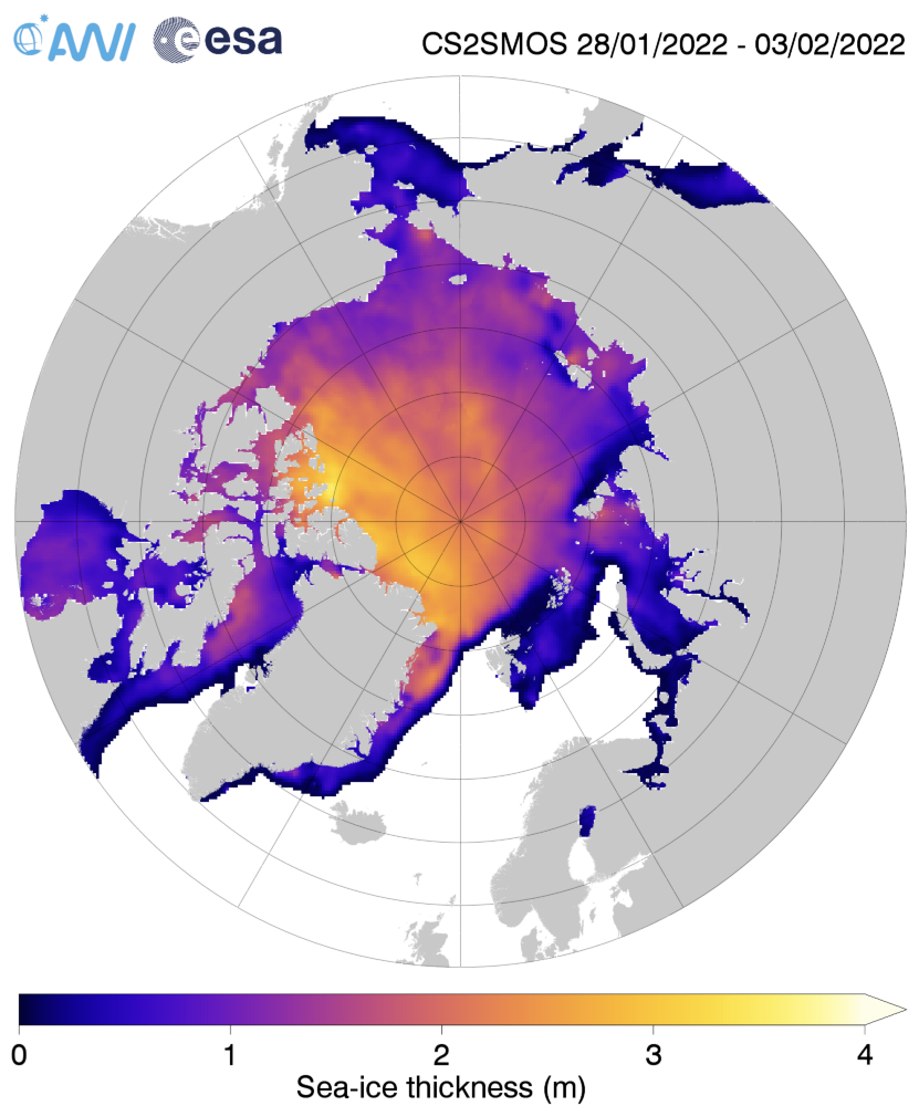
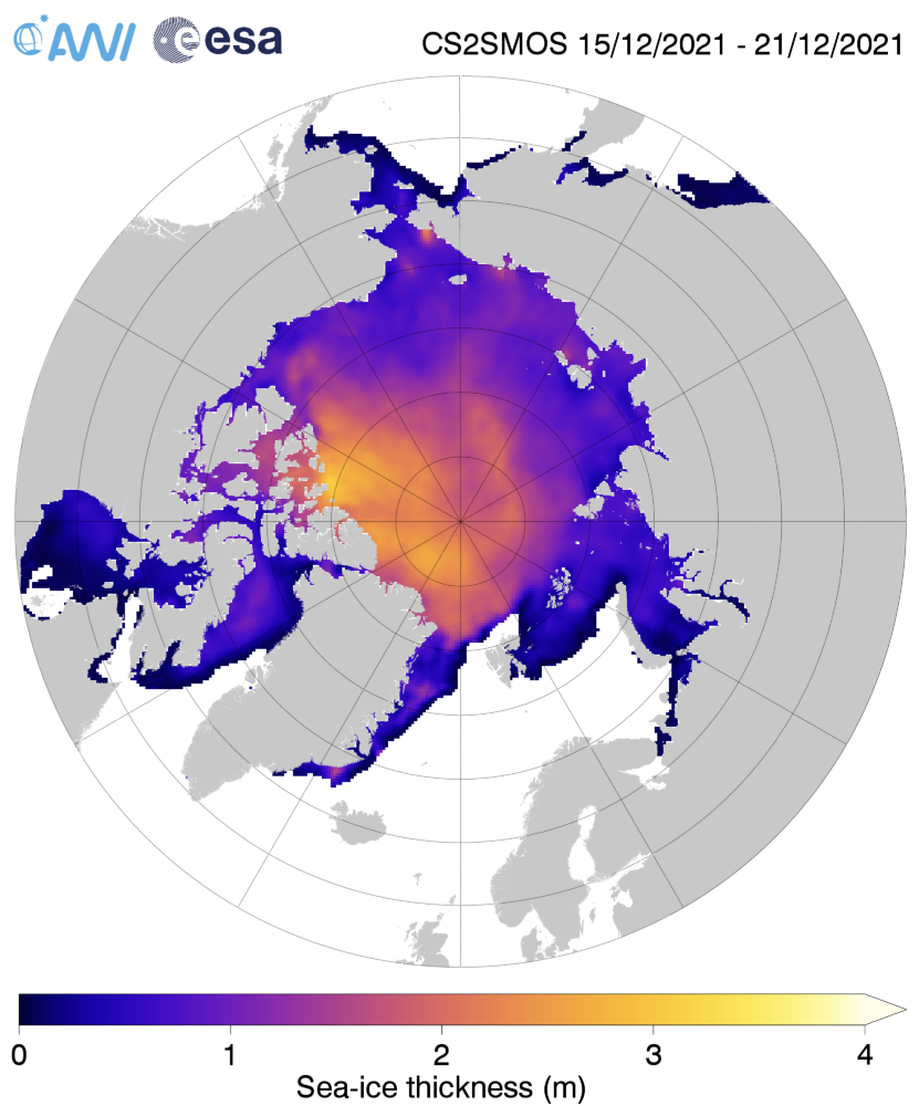
It doesn’t reveal a similar “blip” towards the end of January, suggesting that reduction in area was due to compaction rather than melt. The current AWI thickness map shows the freshly formed ice north east of Svalbard is still very thin:
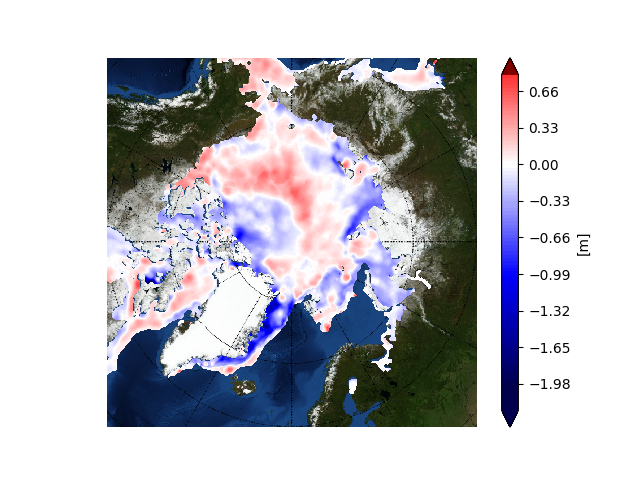
The latest thickness anomaly map from the Finnish Meteorological Institute shows that the ice which was exported from the Central Arctic via the Fram Strait is nevertheless still anomalously thin, although there is now an area of thicker ice north of Greenland:
2021 has been and gone, so first of all may I wish all our readers a very Happy New Year.
Sadly it’s not been a happy start to 2022 for the inhabitants of Boulder, Colorado, home of the National Snow and Ice Data Center. According to the Denver Post:
The Marshall fire destroyed an estimated 991 homes in Boulder County, damaged 127 more and may have killed three people, Sheriff Joe Pelle said Saturday afternoon.
Pelle added that the cause of the fire — the most damaging in Colorado history — remains under investigation, and confirmed that sheriff’s officials have served a search warrant on at least one property based on a tip.
Currently, two people are missing in Superior and another is missing in the Marshall area, Pelle said. All three are feared dead as each of their homes was lost to the fire, the sheriff said…
So far, officials say Thursday’s wildfire — exacerbated by 100-mph winds — burned more than 6,000 acres across Boulder County.
The fire destroyed 553 homes in Louisville, damaging 45, Pelle said Saturday. It also destroyed 332 homes in Superior, damaging 60 in that town, and destroyed 106 homes in unincorporated Boulder County, damaging 22…
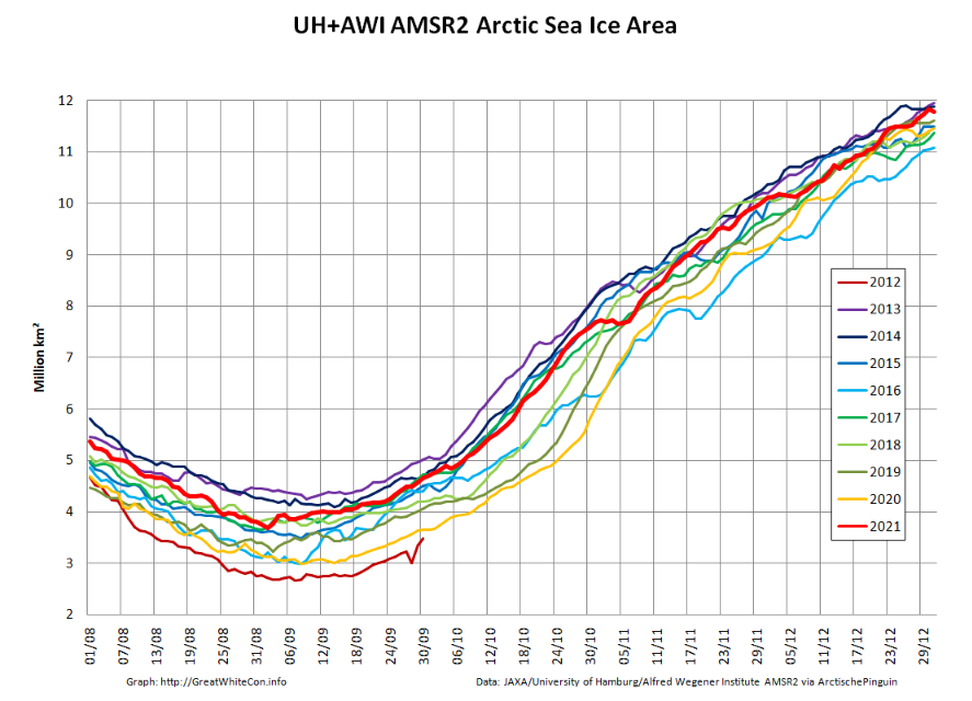
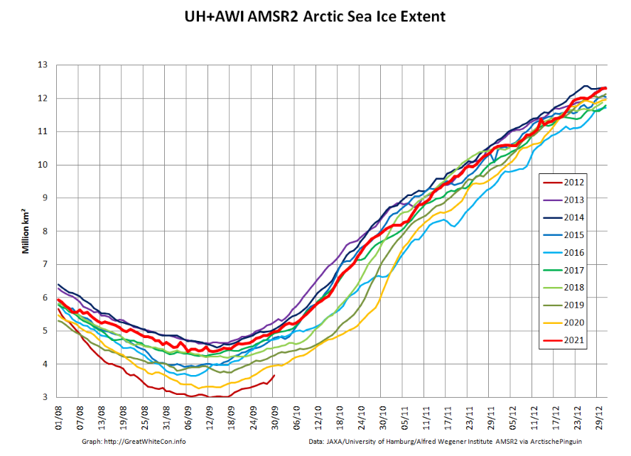
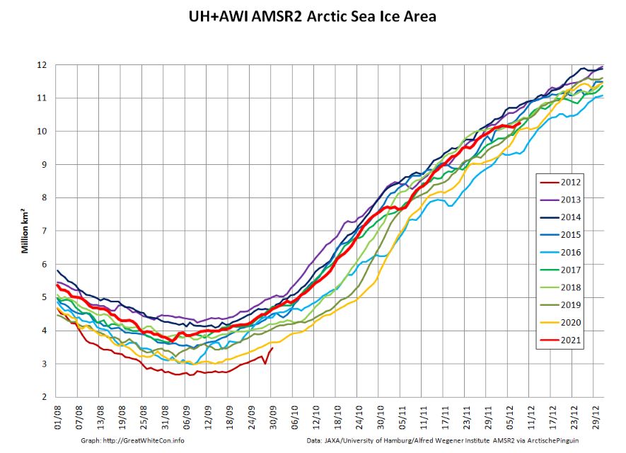
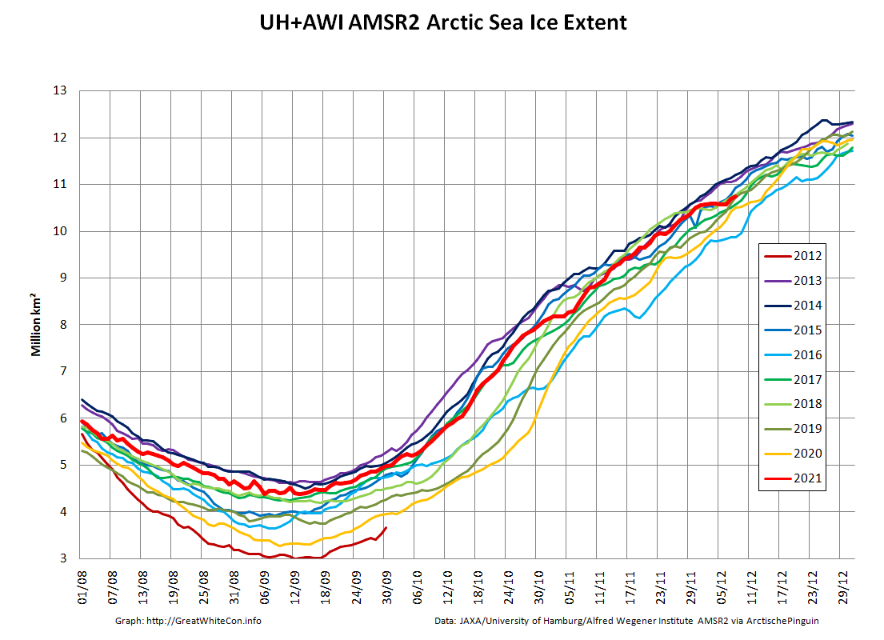
Moving north to examine snow and ice data from the Arctic, let’s start 2022 in traditional fashion with a look at high resolution AMSR2 area and extent:
Both metrics are now near the upper boundary of the last 10 years’ range. The AMSR2 instrument wasn’t launched into orbit until summer 2012, but according to both JAXA and NSIDC data extent on January 1st 2022 is almost identical to the same date in 2012. Regular readers will recall that year went on to produce the lowest annual minimum extent in the satellite era despite recording the highest annual maximum in the decade of the 2010s:
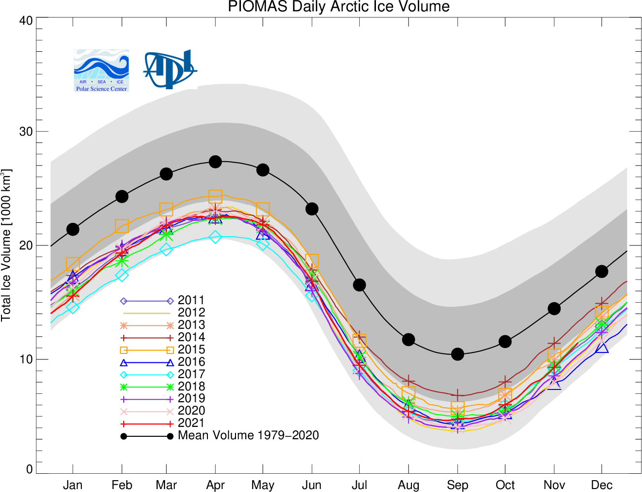
Note that sea ice volume tells a rather different story. Here’s the latest AWI CryoSat-2/SMOS volume graph:
The current near real time data is likely to be revised upwards slightly when the final reanalysis is complete, but even so volume seems likely to remain in the lower half of the recent range at the end of 2021.
Once again the ice in the so called “last ice area” north of Greenland and Ellesmere Island is thinner than usual, as is the ice in the Fram Strait and East Greenland Sea.
[Edit – January 11th]
As has been pointed out below, the Polar Science Center has now released the PIOMAS volume data for December 2021:
Average Arctic sea ice volume in December 2021 was 13,300 km3. This value is the 9th lowest on record for December, about 2100 km3 above the record set in 2016. Monthly ice volume was 51% below the maximum in 1979 and 37% below the mean value for 1979-2020. Average December 2021 ice volume was 1.2 standard deviations above the 1979-2020 trend line.
November and December of 2021 saw relative rapid ice growth for recent years, bringing the mean ice thickness (above 15 cm thickness) towards the thicker end of the recent values.
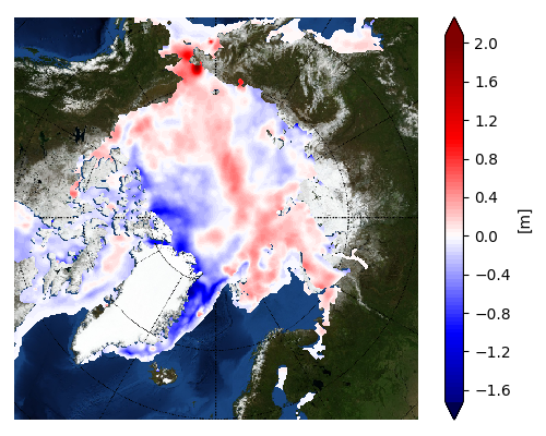
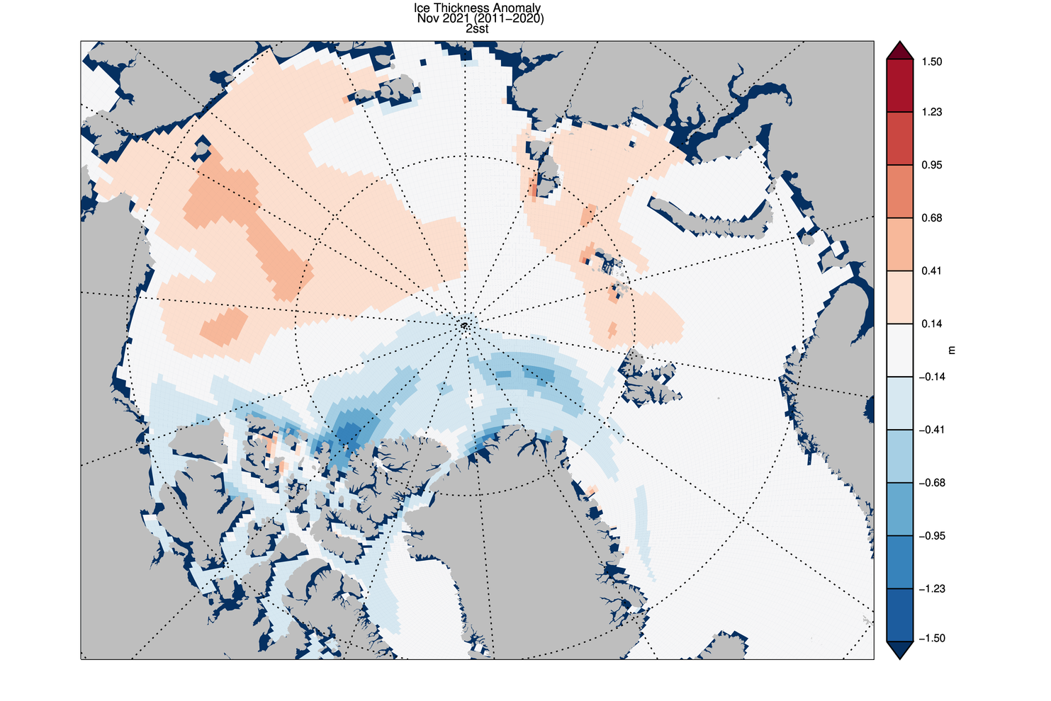
The ice thickness anomaly map for December 2021 relative to 2011-2020 continues to show anomalies divided into positive and a negative halves with areas of positive anomalies increasing since the two prior months and stretching from the Beaufort, over the pole and into the Barents. Negative anomalies stretching from Fram Strait, North of Greenland and along the Canadian Archipelago. Areas North of Greenland again feature low ice thickness as in prior years.
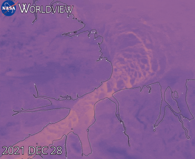
Note that as revealed by this animation from NASA Worldview the sea ice in the Lincoln Sea is currently still breaking up and being exported from the Central Arctic via the Nares Strait:
[Edit – January 25th]
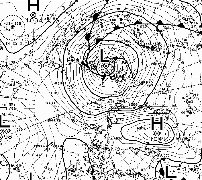
The Atlantic side of the Arctic Ocean has been taking a bit of a battering from what I shall henceforth refer to as the Great Arctic Winter Cyclone of 2022, or GAWC 2022 for short. Unless there’s an even deeper one later in the year of course!
According to the Canadian Meteorological Centre the storm achieved a minimum Mean Sea Level Pressure of 937 hPa at 12 noon UTC yesterday:
Here are the visible effects of the storm on the sea ice in the area so far, now updated to January 25th:
My apologies for the mixed metaphors in today’s title, but the news I bear is beyond bizarre.
In a press release earlier today The Global Warming Policy Foundation proudly announced that:
A new paper by an eminent meteorologist says that trends in polar sea-ice levels give little cause for alarm. The paper, by Professor J. Ray Bates has just been published by the Global Warming Policy Foundation.
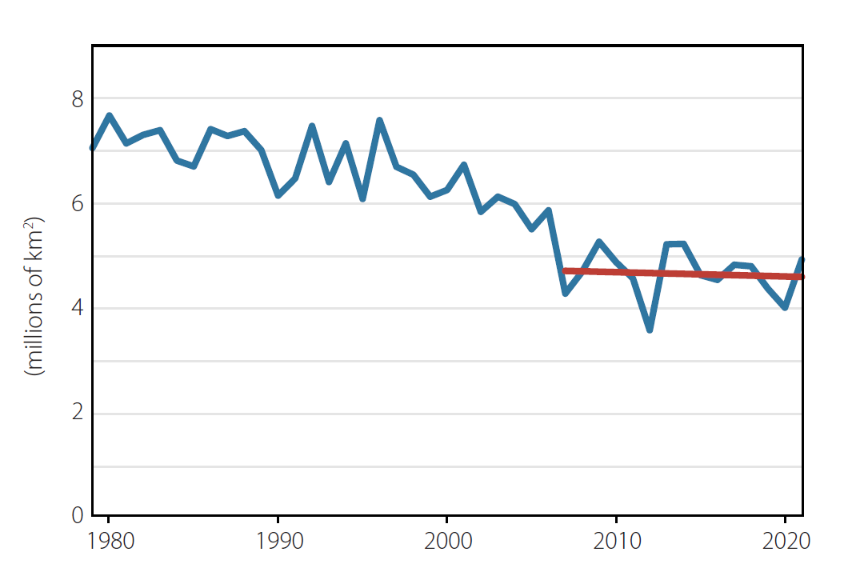
According to Professor Bates, climate model simulations indicate significantly decreasing sea ice levels in both hemispheres, with the greatest decreases occurring in September each year. However, the observed September trend in the Antarctic is actually slightly upwards, and while observed levels in the Arctic have fallen over the last 40 years, they have been quite stable since around 2007.
Professor Bates said:
“In 2007, Al Gore told us that Arctic sea ice levels were ‘falling off a cliff’. It’s clear now that he was completely wrong. In fact, the trends in sea-ice are an antidote to climate alarm.”
Professor Bates also says that little reliance should be placed on model simulations of future sea-ice decline:
“Climate models failed to predict the growth in Antarctic sea ice, and they missed the recent marked slowdown of sea-ice decline in the Arctic. It would be unwarranted to think they are going to get things right over the next 30 years.”
Professor Bates’ paper is published today, and can be downloaded here (pdf).
By all means download Ray’s “paper” from the link above and take a look at his introduction, which begins as follows:
The recent publication of the book Unsettled by Steven Koonin has led to the likelihood of increased scrutiny of the perception of a climate emergency,1 an idea which has become so widely established in recent years. Koonin, a former scientific advisor to the Obama administration, has demonstrated that what the public are being told by the media is not necessarily what the scientists are saying. He has also shown that what is being relayed in the national and UN climate assessments has often been written for the purpose of persuading rather than informing.
Unsettled clearly shows that important aspects of climate science, which the public have been persuaded to regard as beyond dispute are, in fact, quite unsettled.
Regular readers may recall that as soon as Steve’s book was published in machine readable format we established that it made no mention whatsoever of sea ice, whether of the Arctic or Antarctic variety.
Furthermore, when I attempted to debate that fact with Prof. Koonin he disappeared without trace before justifying that strange omission, beyond asserting that:
The topic is somewhat distant from ordinary folks’ perception.
It seems that Prof. Bates and the GWPF disagree with Prof. Koonin on this topic, since presumably their “paper” is addressed to ordinary folks? Ray even explicitly states that:
Although Unsettled covers a broad spectrum of climate topics, it does not treat in depth the issue of recent polar sea-ice trends, which are key indicators of changes in the global climate.
His “paper” goes on to assert in section 2 that:
Since the introduction of passive-microwave satellite observations in the late 1970s, polar sea-ice extent has been among the most accurately observed climate indicators. Sea-ice volume, on the other hand, is much more difficult to measure.
So far so good I suppose, but then we are told:
In December 2007, former US vice-president Al Gore, in his Nobel Peace Prize acceptance speech in Oslo, referred to scientific studies warning that the Arctic sea ice was ‘falling off a cliff’. He highlighted forthcoming model results that projected largely ice-free Arctic summers in ‘as little as seven years’. He repeated this warning two years later at the 2009 COP15 climate meeting in Copenhagen.
Gore’s claim was based on a study by researchers from the US Naval Postgraduate School, who used a regional model of the sea ice–ocean system in the Arctic, constrained using observational data for the 12-year period 1996–2007, and concluded that the Arctic would be nearly ice-free in summer by 2016 (plus or minus three years).
Prof. Bates seems blithely unaware that we thoroughly debunked this nonsense many moons ago. What Prof. Wieslaw Maslowski, one of those pesky “researchers from the US Naval Postgraduate School”, actually said in December 2007 was:
If we project this trend ongoing for the last 10–15 years, we probably will reach zero in summer some time mid next decade.
Reiterate for the benefit of those who seem unable to understand either English or Mathematics that a “projection” is not the same thing as a “prediction”.
preferring instead a version of his own construction, which looks like this:
Ray then confidently asserts that:
The current slowdown in the rate of sea-ice loss was not expected, and the reasons for it are uncertain.
Sadly Ray’s exhaustive list of references fails to mention this learned journal article from 2011 by authors from the University of Washington and Los Alamos National Laboratory, which not only anticipated such a “slow transition” but also offered reasons for it:
Given the strong thickness–growth feedback of sea ice (Bitz and Roe 2004), where in a warming climate we can expect the thicker MY ice to thin at a greater rate than the thinner FY ice, and the fact that the ratio of MY to FY ice entering into the MY ice category each year is decreasing, it is likely that the difference between FY and MY ice survival ratios will decrease in a warming climate. If this occurs, the Arctic sea ice system would move toward a regime of decreased memory and decreased sensitivity to climate forcing…
There is of course plenty more GWPF sea ice nonsense where that lot came from, but it’s already past my tea time (UTC) and so further debunking will have to wait a while. In the meantime here’s a wake up call for Professor J. Ray Bates:
[Edit – December 17th]
Moving further down section 2 Ray assures us that:
Any objective discussion of the recent Arctic sea-ice decline also requires that some consideration be given to the evidence regarding past natural variability on a multi-decadal timescale. In the pre-satellite era, reliable data on sea-ice coverage was sparse.
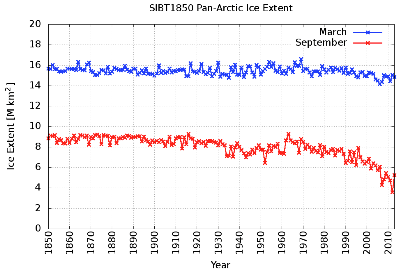
By combining the temperature and partial sea-ice records, statistical reconstructions of the total sea-ice extent going back to the early 1900s can be created. Some of these reconstructions indicate that between the 1900s and 1940s, Arctic sea-ice extent comparable to the present reduced levels may have occurred.
Ray doesn’t sound very certain, which is perhaps because the paper in question blithely states that:
Because Arctic sea ice trends are closely correlated to Arctic temperature trends, they are often discussed in the context of global temperature trends.
Maybe so, but to the best of my recollection Connolly et al. never attempt to “prove” the asserted correlation. Here’s an alternative assessment of “Arctic sea-ice extentbetween the 1900s and 1940s“:
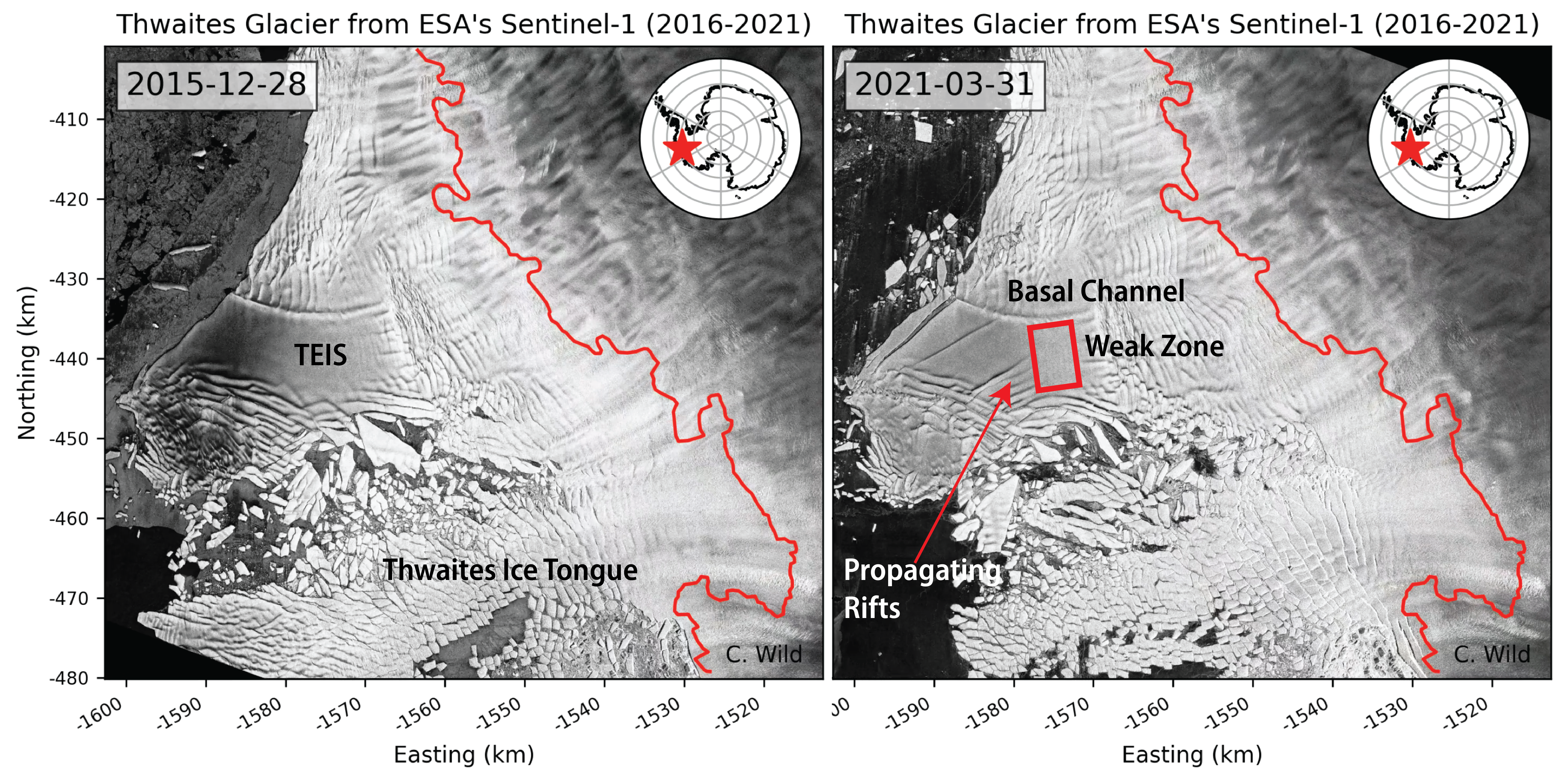
An alarming crackup has begun at the foot of Antarctica’s vulnerable Thwaites Glacier, whose meltwater is already responsible for about 4% of global sea level rise. An ice sheet the size of Florida, Thwaites ends its slide into the ocean as a floating ledge of ice 45 kilometers wide. But now, this ice shelf, riven by newly detected fissures on its surface and underside, is likely to break apart in the next 5 years or so, scientists reported today at a meeting of the American Geophysical Union.
The most dramatic sign of impending failure is a set of diagonal fractures that nearly span the entire shelf. Last month, satellites spotted accelerating movement of ice along the fractures, says Erin Pettit, a glaciologist at Oregon State University, Corvallis, who is part of a multiyear expedition studying the glacier. The shelf is a bit like a windshield with a series of slowly opening cracks, she says. “You’re like, I should get a new windshield. And one day, bang—there are a million other cracks there.”
Here’s an image from the AGU abstract to illustrate the “cracks” Erin referred to:
Image: Christian Wild, Oregon State University
Once the ice shelf shatters, large sections of the glacier now restrained by it are likely to speed up, says Ted Scambos, a glaciologist at the University of Colorado, Boulder, and a leader of the Thwaites expedition. In a worst case, this part of Thwaites could triple in speed, increasing the glacier’s contribution to global sea level in the short term to 5%, Pettit says.
Here is the AGU press conference that caused all the excitement:
Not a lot of people know that our headline for today (apart from the terminating question mark) has been shamelessly plagiarised from Paul Homewood’s latest Arctic article. This will give you a flavour of Paul’s purple prose:
Electroverse have uncovered some blatant data tampering by DMI:
“It would appear that the Danish Meteorological Institute (DMI) may have taken a leaf out of NASA’s ‘data-fudging 101‘.
Sometime between late-Nov and early-Dec this year, the DMI’s Arctic Sea Ice Volume chart experienced a mysterious ‘vanishing’ of ice — this is revealed by a direct comparison of the Nov 18th and the Dec 8th charts below.”
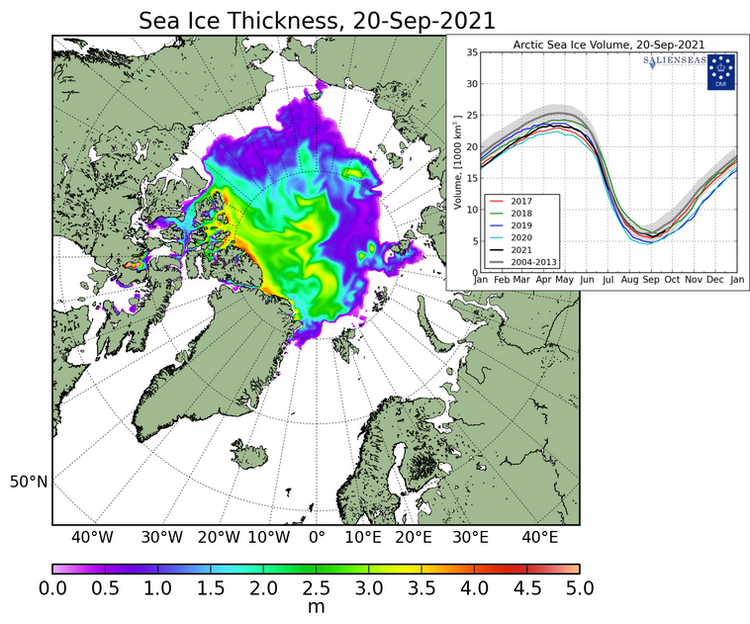
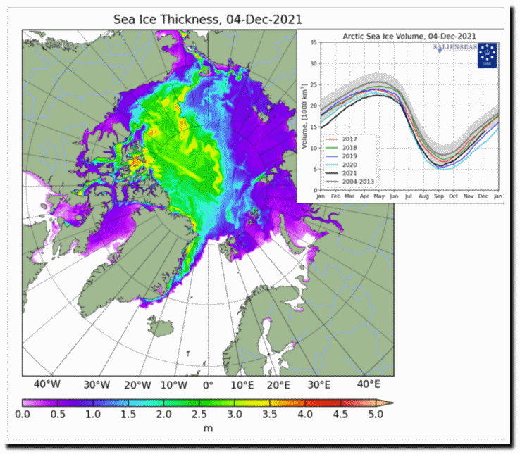
I am able to corroborate their findings. In September I took this screenshot of DMI sea ice thickness. Note that the black line for this year was close to the 2018 line, and above 2017 for Sep 20th:
But the new version shows this year well below those two years:
There is no other way to describe this than blatant fraud. The changes do not appear to have been even documented, and the old data is not archived, being simply “replaced”. These should surely be very basic scientific requirements.
Neither does there appear to have been any public announcement by DMI about the fact or the justifications for what amounts to a significant change.
What this episode means is that DMI can no longer be trusted to produce honest, reliable data. It also raises the question of whether similar tampering has been carried out in previous years, without anybody being aware. After all, it is only by pure accident that it has been spotted this time.
Even fewer people know that my helpful explanatory comment is currently invisible to Paul’s band of merry (mostly) men:
Should anyone contrive to click on the invisible link this what they would see just below the DMI’s recent Tweet:
Quite predictably Tony Heller has also jumped on the self same bandwagon, claiming in an article entitled “Rapidly Disappearing Arctic Ice” that:
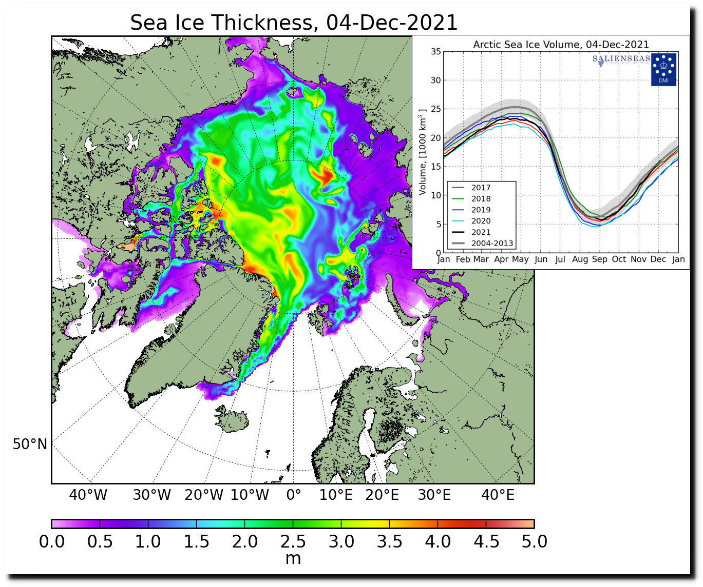
On December 4, DMI showed Arctic sea ice volume above the 2004-2013 average:
Quite predictably, the data disappeared for three days, and now that it has returned, DMI has massively reduced the amount of sea ice in the Arctic. Much of the thick ice off the coast of Siberia has disappeared:
In normal circumstances I would of course point out the error of his ways to Tony via Twitter. However:
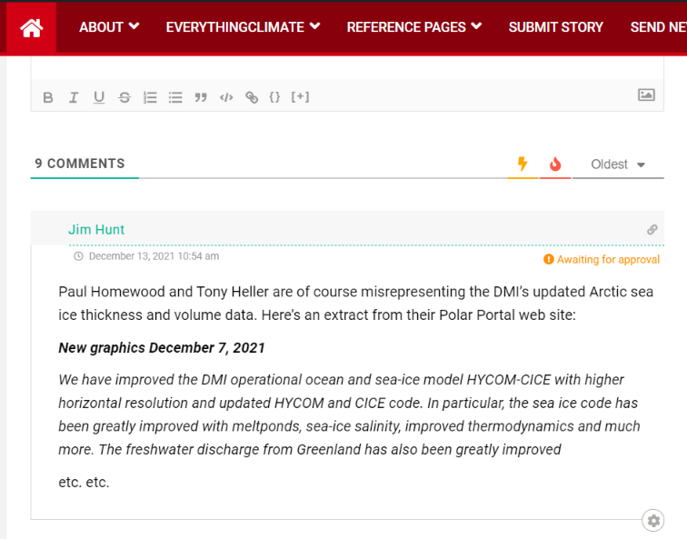
Here is the DMI’s explanation for the recent change in their Arctic sea ice thickness/volume visualisations, as shown on their “Polar Portal” web site:
New graphics December 7, 2021
We have improved the DMI operational ocean and sea-ice model HYCOM-CICE with higher horizontal resolution and updated HYCOM and CICE code. In particular, the sea ice code has been greatly improved with meltponds, sea-ice salinity, improved thermodynamics and much more. The freshwater discharge from Greenland has also been greatly improved using freshwater product from GEUS, which especially improves the coastal ocean currents and thus the ice transport nearshore Greenland. The model has been running continuously since September 1990. Therefore, we have by December 07, 2021 updated the graphics of sea-ice thickness and volume using the new and improved data on Polarportal and ocean.dmi.dk.
The improved model setup has led to higher variability as well as less abrupt melting during the melt season, which gives a shift of approximately half a month for the time of minimum ice volume. The trend between the years is almost unchanged. Thereby, a year with a large sea-ice volume in the old setup also has a large volume in the new setup, and similar for years with low sea-ice volume.
I always thought that “skeptical” folk didn’t much care for the output of “climate models” but I guess I must have been mistaken?
[Edit – December 13th]
Needless to say my comment at NALOPKT is still invisible this evening. However credit where credit is due. Tony Heller has at least not censored my comments on his blog. Earlier today Watts Up With That referred to both the Heller and Homewood DMIGate2 articles. Do you suppose the following helpful comment of mine will ever see the light of day at WUWT?
Watch this space for more #DMIGate2 news as and when we receive it!
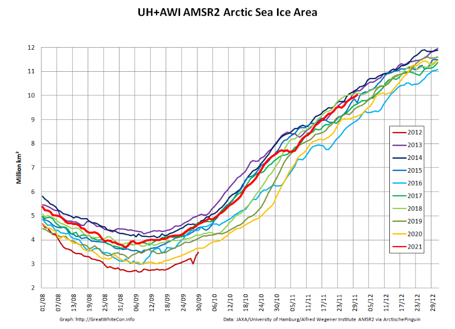
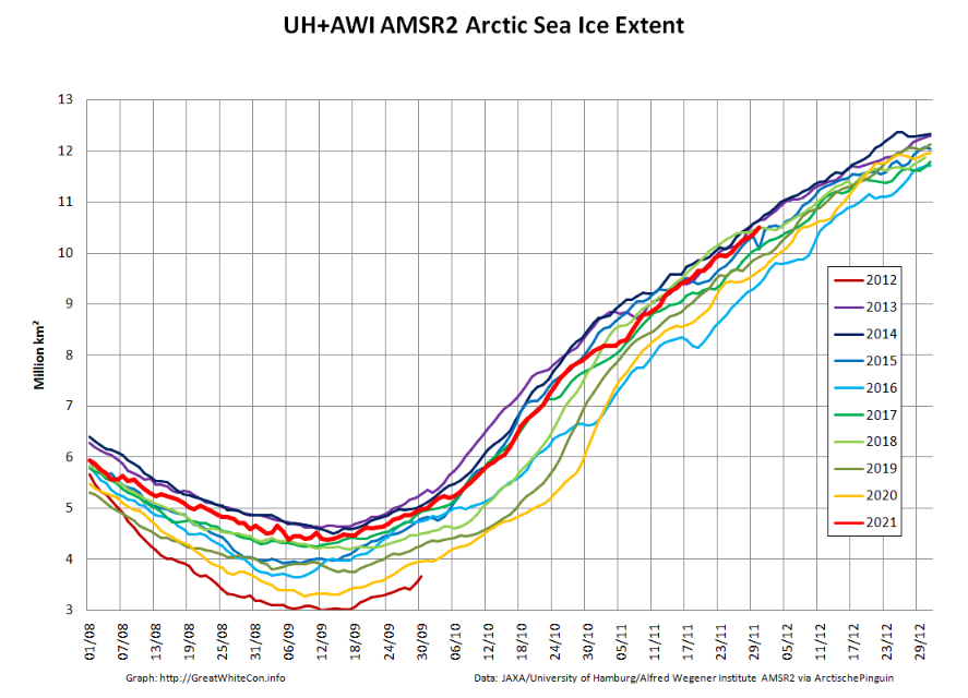
Christmas is coming. Santa’s secret summer swimming pool has frozen over. The time has come for a new monthly Arctic update.
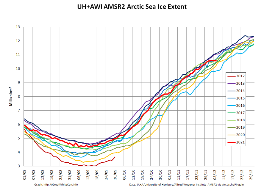
The JAXA/ADS/ViSHOP web site is undergoing maintenance for a week, so let’s start the festive season with a look at high resolution AMSR2 area and extent:
After a brief hiatus in early November both metrics are once again tracking within, but near the upper bound of the last 10 years.
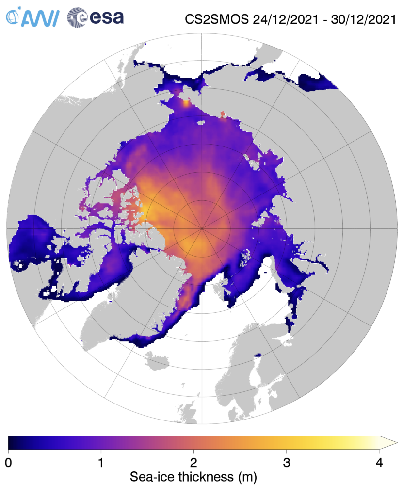
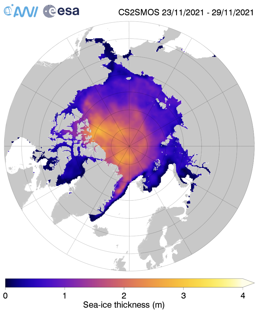
Next let’s take a look at the latest AWI CryoSat-2/SMOS thickness map:
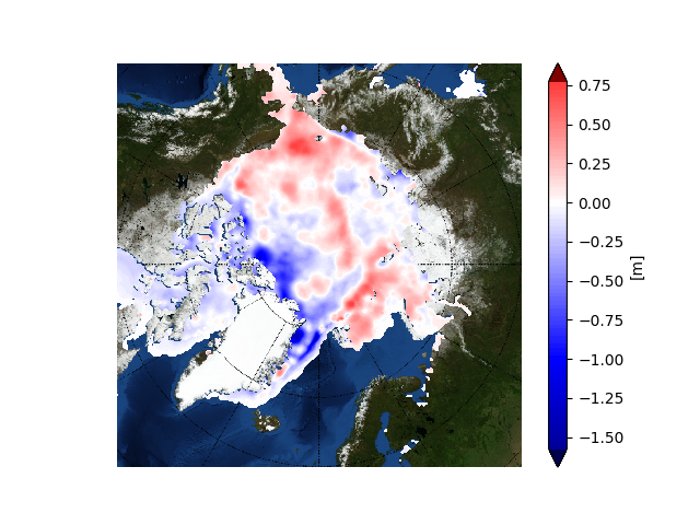
together with the anomaly map from the Finnish Meteorological Institute:
Still thinner than usual in the so called “last ice area” north of Greenland and Ellesmere Island, and thicker than usual on the Siberian side of the Arctic, particularly in the Chukchi Sea.
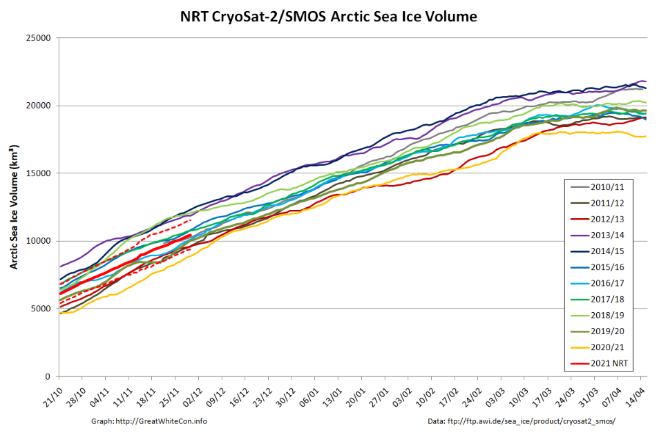
Finally, for the moment at least, here’s the latest CryoSat-2/SMOS volume graph:
Unlike the previous metrics, this particular one is close to the middle of the pack.
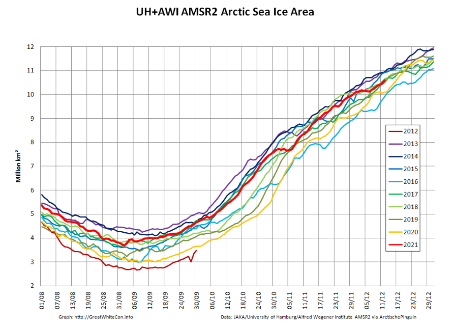
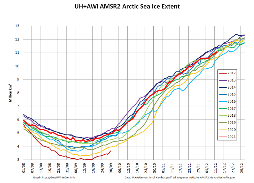
Sea ice extent increased at a faster than average pace through November and by the end of the month, extent was just within the interdecile range. Extent was above average in the Bering Sea, but Hudson Bay remained unusually ice free through the month.
The November 2021 monthly average extent was 9.77 million square kilometers (3.77 million square miles), which ranked tenth lowest in the satellite record. The 2021 extent was 930,000 million square kilometers (359,000 million square miles) below the 1981 to 2010 long-term average. Extent was higher than average in the Bering Sea, but is extremely low in Hudson Bay.
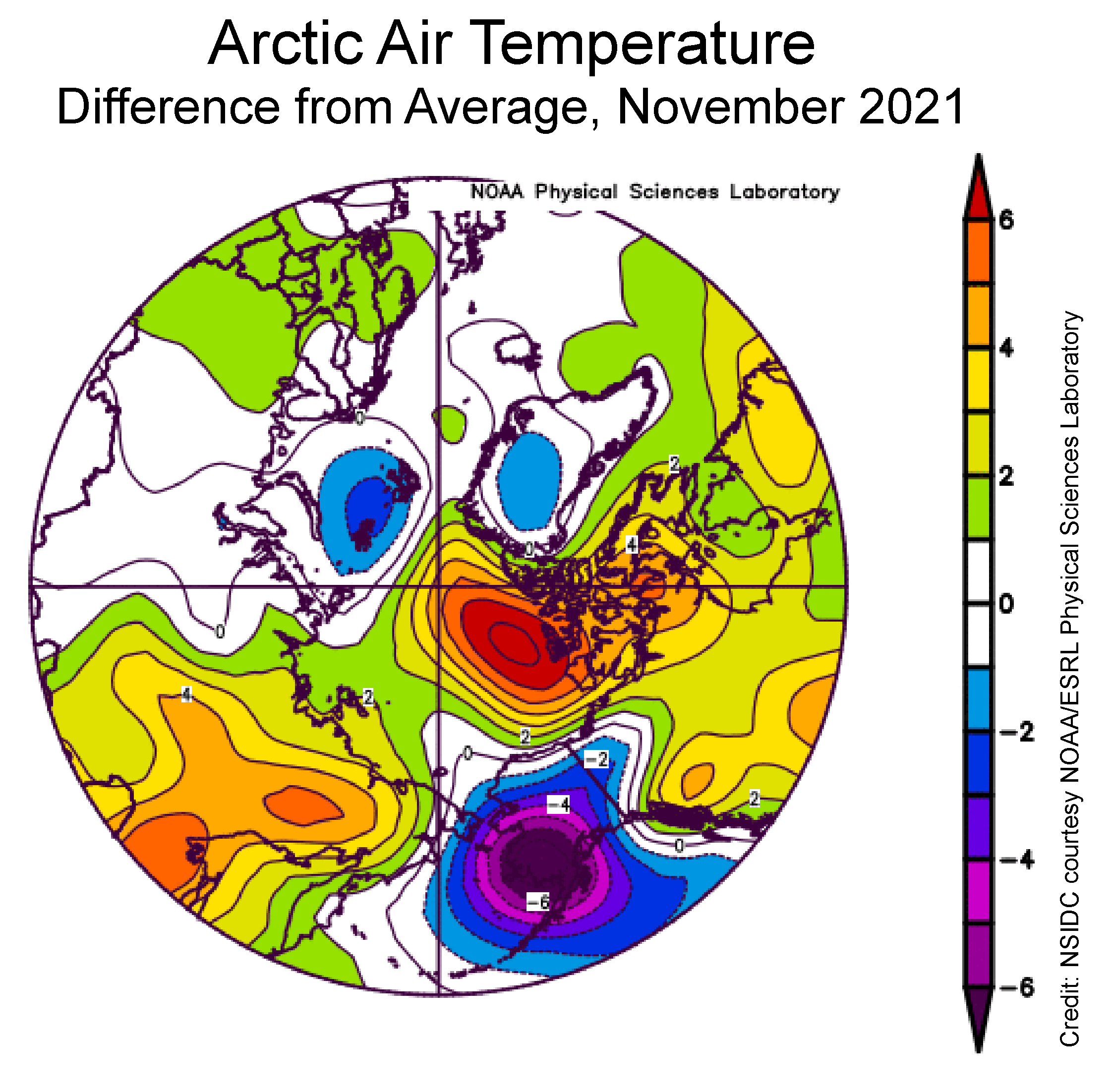
Air temperatures at the 925 millibar level (about 2,500 feet above the surface) were well above average north of the Canadian Archipelago, by as much as 6 degrees Celsius. Conversely, temperatures over southwest Alaska and the eastern sector of the Bering Sea were as much as 6 degrees Celsius below average:
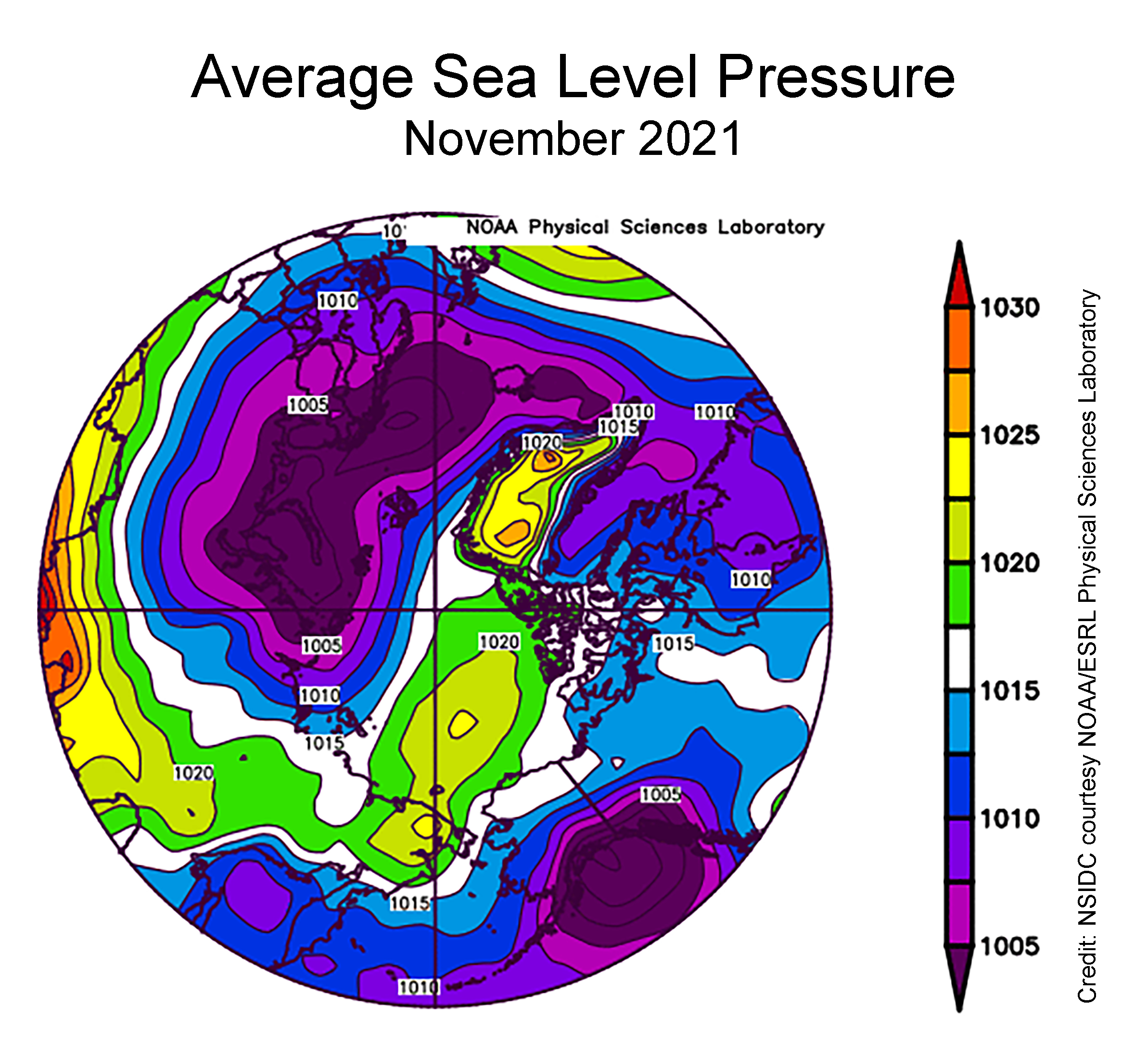
The sea level pressure pattern for November featured widespread low pressure over the Atlantic side of the Arctic and extending into the Barents and Kara Seas, paired with a moderately strong Beaufort Sea High. Strong low pressure over the Gulf of Alaska resulted in a circulation pattern in the eastern Bering Sea that brought cold air from the north. This pattern was favorable for sea ice growth, and can explain the above average ice extent in the region:
[Edit – December 7th]
Since the start of December high resolution AMSR2 extent has been flatlining:
Sea ice area has even declined slightly over the past few days:
Here too is an animation created by Uniquorn on the Arctic Sea Ice Forum using AWI ASMR2 data to reveal ice movement through the Nares Strait during December:
[Edit – December 9th]
The JAXA/ADS/ViSHOP web site is down again, so let’s take another look at high resolution AMSR2 area and extent:
It seems that the “brief hiatus” is over, and extent is now in a “statistical tie” with 2018/19 at 4th lowest for the date amongst recent year.
[Edit – December 13th]
The PIOMAS Arctic sea ice volume data for November 2021 has been released:
Average Arctic sea ice volume in November 2021 was 7,830 km3. This value is the 7th lowest on record for November, about 1600 km3 above the record set in 2016. Monthly ice volume was 61% below the maximum in 1979 and 45% below the mean value for 1979-2020. Average November 2021 ice volume was about one sigma above the 1979-2020 trend line. October saw relative rapid ice growth for recent years bringing the mean ice thickness (above 15 cm thickness) above the recent low values:
The ice thickness anomaly map for November 2021 relative to 2011-2020 continues to show anomalies divided into positive and a negative halves with areas of positive anomalies increasing since the two prior months. Negative anomalies stretching from North of Greenland and along the Canadian Archipelago across the Eastern Arctic into the Barents Sea. Areas North of Greenland again feature very low ice thickness as in prior years (see our recent paper). Positive anomalies are notable in the Beaufort and Chukchi seas due to advection of thicker older ice into the areas during the previous winter (See recent paper on this). The Alaskan summer has also been relatively cold contributing to unusually thick ice in this area:
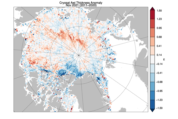
CryoSat-2 ice thickness shows a similar picture sea ice thickness anomalies but with the maxima slightly displaced which maybe due to temporal sampling of the composite:
The JAXA web site is still down, so here’s another set of high resolution AMSR2 graphs:
[Edit – December 14th]
NOAA have just released their 2021 Arctic Report Card. Here’s the introductory video:
“Everybody knows [the Arctic] is a canary when it comes to climate change,” says Peter Jacobs, a climate scientist at NASA’s Goddard Space Flight Center, who presented the work on 13 December at a meeting of the American Geophysical Union. “Yet we’re misreporting it by a factor of two. Which is just bananas.”
Jacob’s co-authors include researchers who oversee several influential global temperature records, and they noted the faster Arctic warming as they prepared to release the global temperature average for 2020. NASA’s internal peer reviewer challenged the higher figure, suggesting the scientific literature didn’t support it. But the researchers have found the four times ratio holds in record sets from both NASA (3.9) and the United Kingdom’s Met Office (4.1), and they hope to soon include the Berkeley Earth record. (Their work also has company: In July, a team at the Finnish Meteorological Institute posted a preprint also arguing for the four times figure.)
The researchers found Arctic warming has been underestimated for a couple of reasons. One is climate scientists’ tendency to chop each hemisphere into thirds and label the area above 60°N as the “Arctic”—an area that would include, for example, most of Scandinavia. But the true definition of the Arctic is defined by Earth’s tilt. And, as has been known for centuries, the Arctic Circle is a line starting at 66.6°N. When researchers lump in the lower latitudes, “you’re diluting the amount of Arctic warming you’re getting,” Jacobs says. “That is not a trivial thing.”
The other difference is the choice of time periods over which the warming rate is calculated. Jacobs and his colleagues focused on the past 30 years, when a linear warming trend emerged for the Arctic. Analyses that look at longer term trends see less divergence between the Arctic and the world.
[Edit – December 23rd]
Here is the latest CryoSat-2/SMOS volume graph, now including some reanalysed data which seems to have come in slightly higher than the earlier “near real time” numbers:
Plus the AWI thickness map:
Further discussion of the divergence between volume and extent continues in the new New Year 2022 thread:
An article by Andy West on the topic of “Public ClimateBall” has now been posted on both Judith Curry’s Climate Etc. and WUWT. Here’s a brief extract from the introduction:
Climate blogger ‘Willard’ has put significant efforts into a large taxonomy of skeptical challenges (the ‘Bingo Matrix’ or ‘Contrarian Matrix’) and brief rejoinders to same. Along with the very useful characterization of especially the rhetoric aspects of the conflicted skeptic / mainstream climate-change blogosphere, as an engagement not based primarily upon rational argument leading where it will, but one with different rules, a kind of ritual or game: ClimateBall™. Everything herein is my own view of ClimateBall, and what it points to.
Which got me thinking about my own experience of playing “the great game”. Checking Twitter for my assorted “plays” over the years, most of them seem to be missing! Hence my Agatha Christie inspired title for today.
They’re not actually “missing” of course, if you know the URLs in advance. However for some strange reason many of them do seem to be missing from Twitter search results. Since Christmas is already less than a month away let’s have a little festive fun shall we? How many “tweets” of mine tagged with the #ClimateBall hashtag can you find that were posted between January 1st 2021 and November 28th 2021? To give you the vaguest of red herring style clues, here’s the most recent one at the time of writing:
Answers on a virtual postcard please, in the space provided for that purpose below. Please also include a brief description of your search methodology.
This website uses cookies to improve your experience. We'll assume you're ok with this, but you can opt-out if you wish. Cookie settingsACCEPT
Privacy & Cookies Policy
Privacy Overview
This website uses cookies to improve your experience while you navigate through the website. Out of these, the cookies that are categorized as necessary are stored on your browser as they are essential for the working of basic functionalities of the website. We also use third-party cookies that help us analyze and understand how you use this website. These cookies will be stored in your browser only with your consent. You also have the option to opt-out of these cookies. But opting out of some of these cookies may affect your browsing experience.
Necessary cookies are absolutely essential for the website to function properly. This category only includes cookies that ensures basic functionalities and security features of the website. These cookies do not store any personal information.
Any cookies that may not be particularly necessary for the website to function and is used specifically to collect user personal data via analytics, ads, other embedded contents are termed as non-necessary cookies. It is mandatory to procure user consent prior to running these cookies on your website.