Tag Archives: MODIS

Moderate Resolution Imaging Spectroradiometer

Facts About the Arctic in July 2020

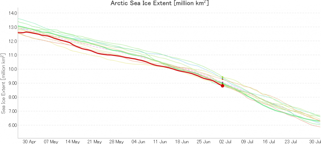
The new month starts with JAXA extent “lowest for the date in the satellite record” by a whisker:
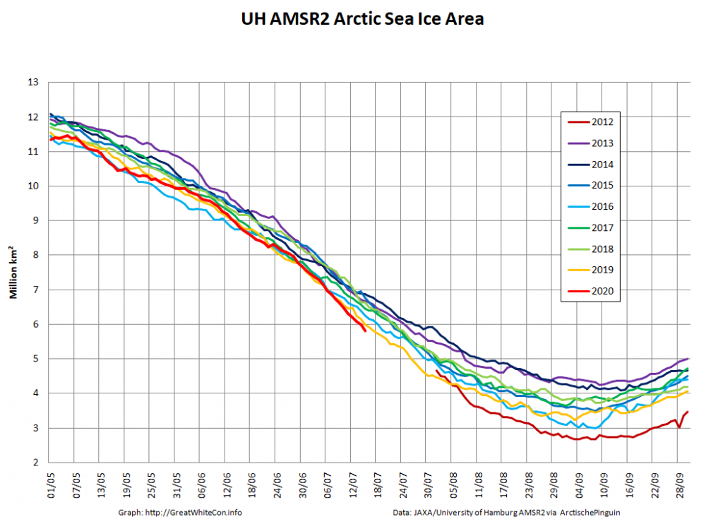
The high resolution Arctic sea ice area and extent graphs based on the University of Hamburg’s AMSR2 concentration data are also in “statistical ties” for that honour, in records going back to 2013:
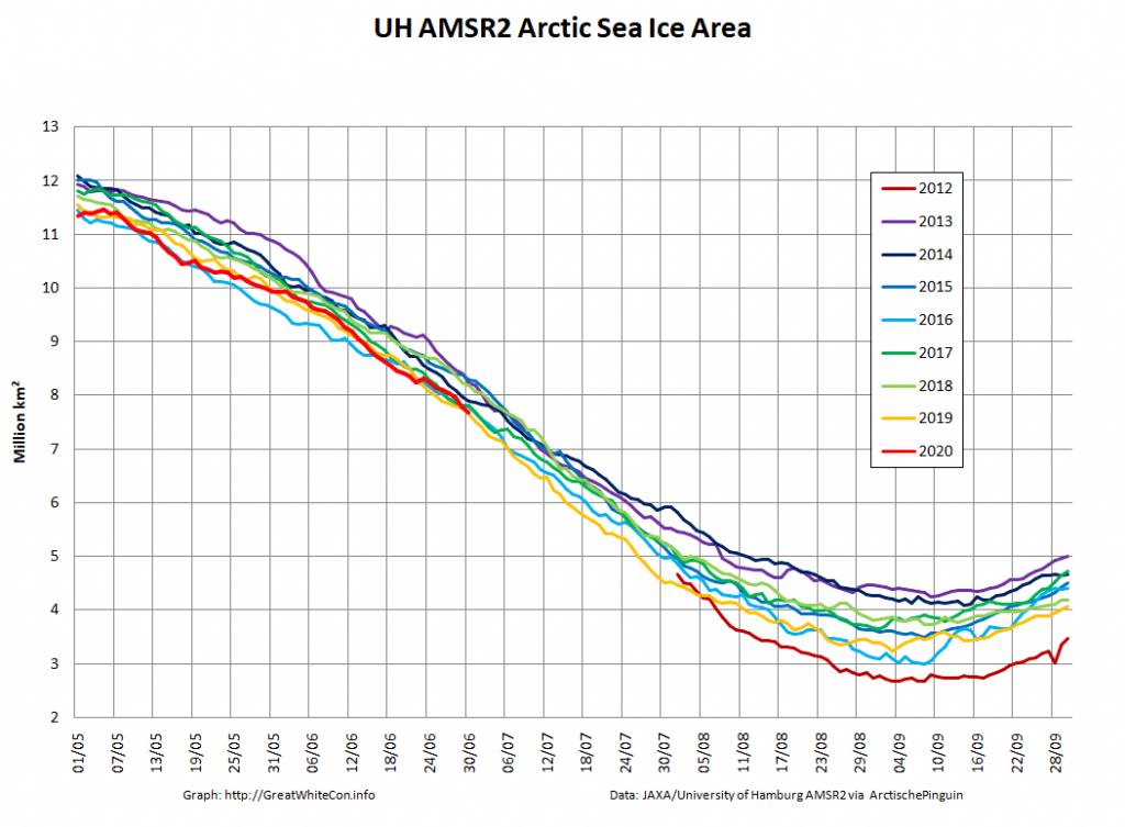
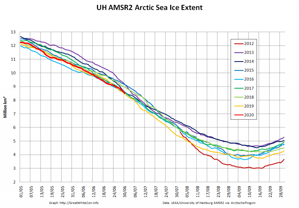
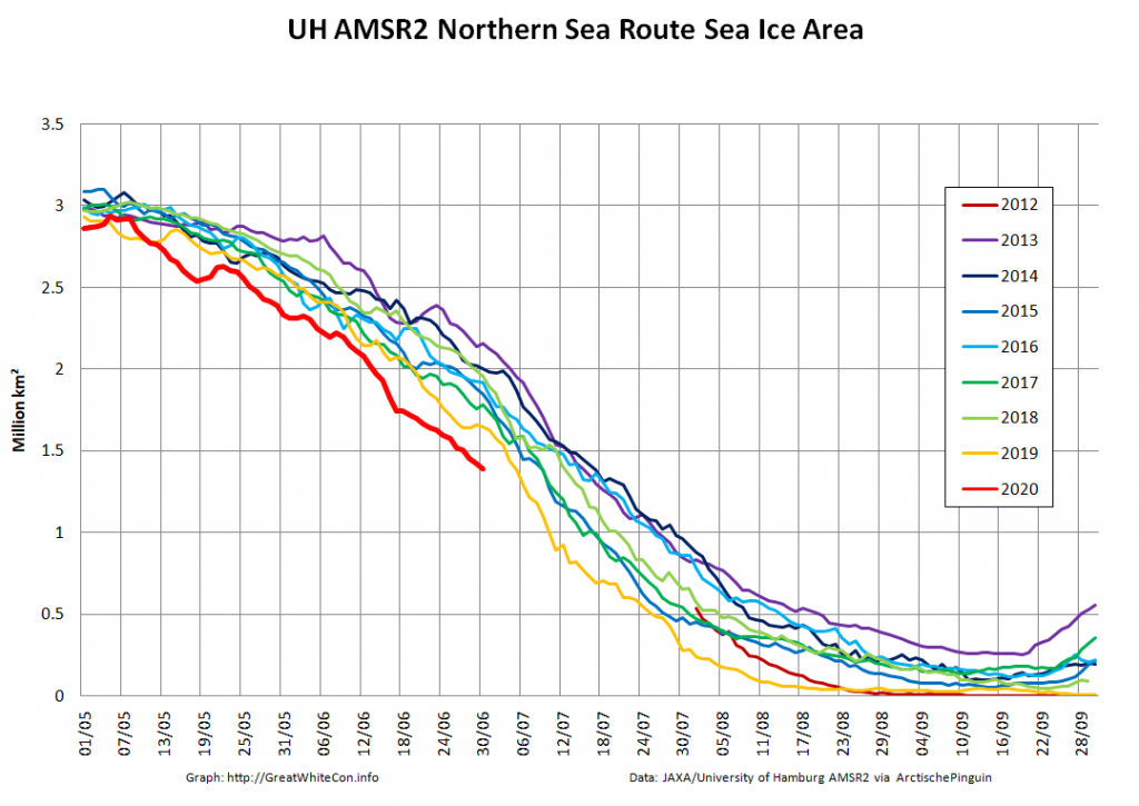
The 2020 melting season currently seems to be a game of two (geographical) halves. The sea ice on the Siberian side of the Arctic is currently at record lows:
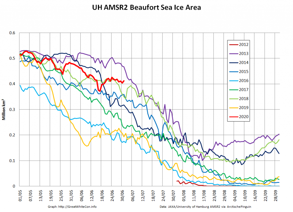
Whereas the Beaufort Sea is near a record high:
Currently the tell tale signs of surface melt are visible across most of the central Arctic, as are the large number of wildfires across Arctic Siberia:
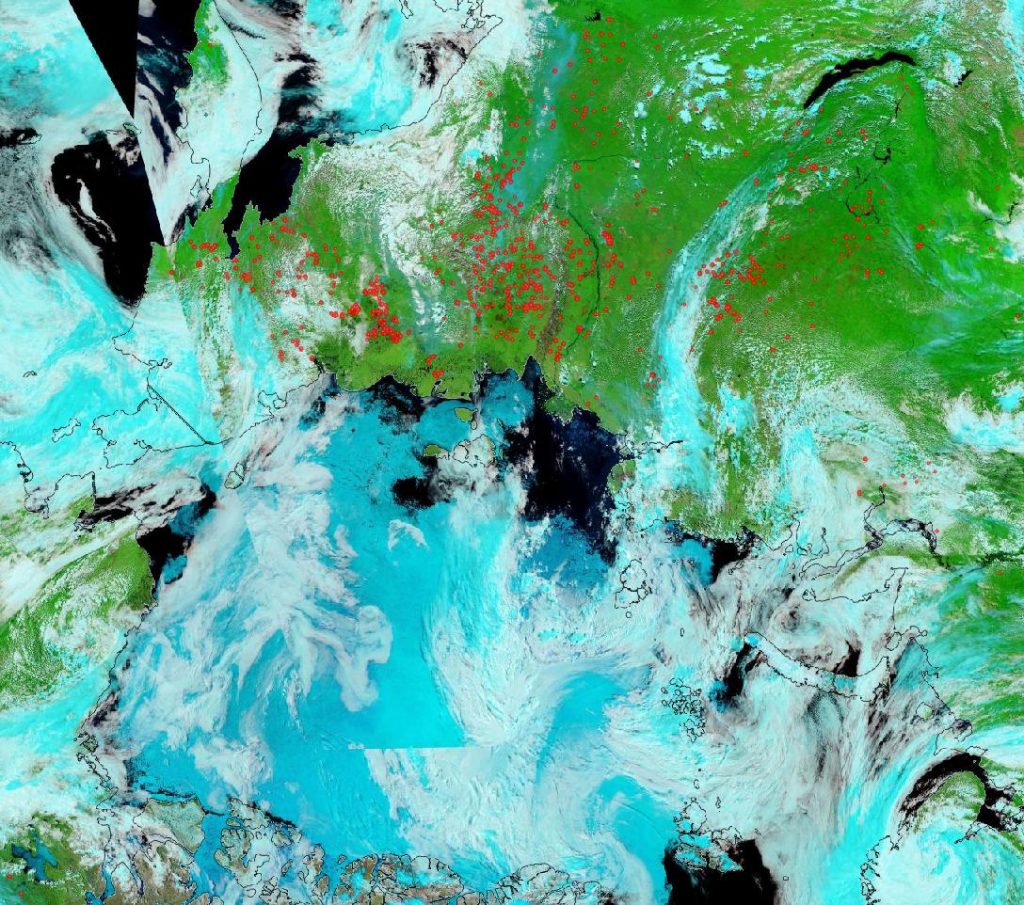
NASA Worldview “false-color” image of the Arctic on July 1st 2020, derived from the MODIS sensor on the Terra satellite

[Edit – July 4th]

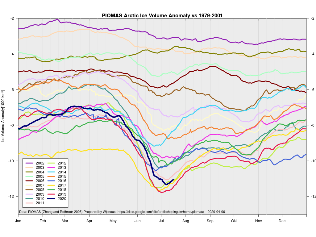
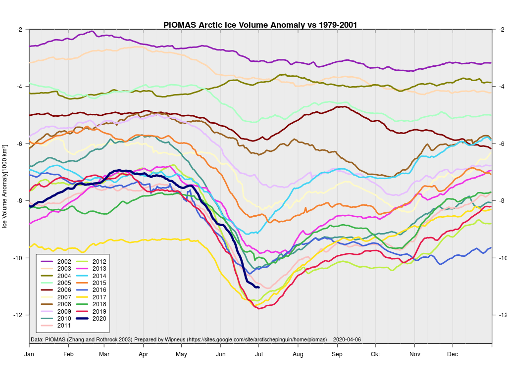
The June 30th PIOMAS gridded thickness numbers have been released, and here are the results of Wipneus’s number crunching:
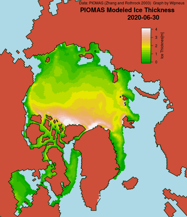
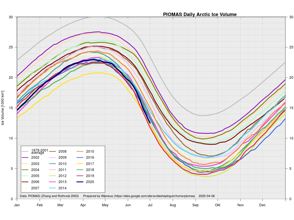
This month including a visualisation of the increasing negative anomaly:
[Edit – July 6th]

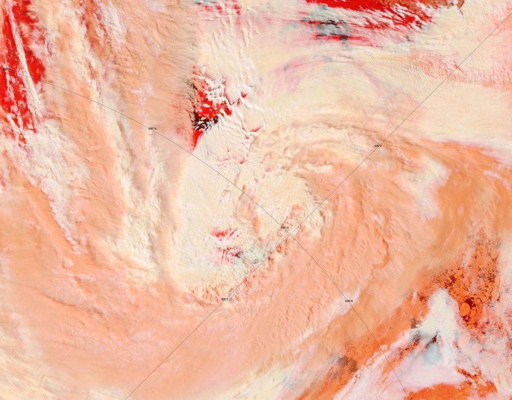
A break in the clouds over the North Pole reveals the onset of surface melt:
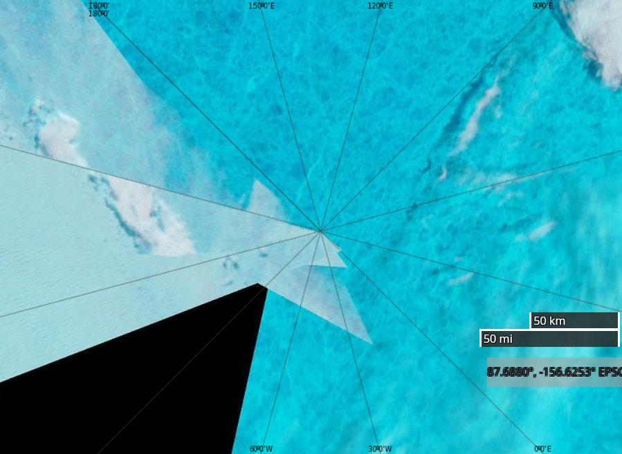
NASA Worldview “false-color” image of the North Pole on July 6th 2020, derived from the MODIS sensor on the Terra satellite

[Edit – July 8th]

After a brief hiatus there are once again some ice mass balance buoys installed at assorted locations across the Arctic. Some have ceased to function, but one of the buoys installed as part of the MOSAiC expedition is still sending back data as it heads towards the Fram Strait. Buoy 387850 is currently located at 81.66 N, 4.19 E. Here’s its ice mass balance plot:
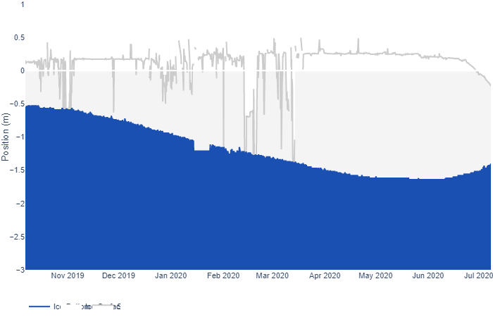
As you can see, both surface and bottom melt are well under way, with just over a meter of ice still remaining.

Now let’s take a look at buoy 386840, currently located at 74.30 N, 132.60 W in the Beaufort Sea:
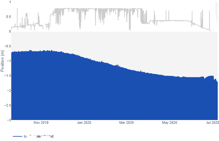
It looks as though the ice thickness has increased, but surely that can’t be right at this time of year? To try and find out I downloaded the raw data and plotted the temperature readings from the buoy’s thermistor string:
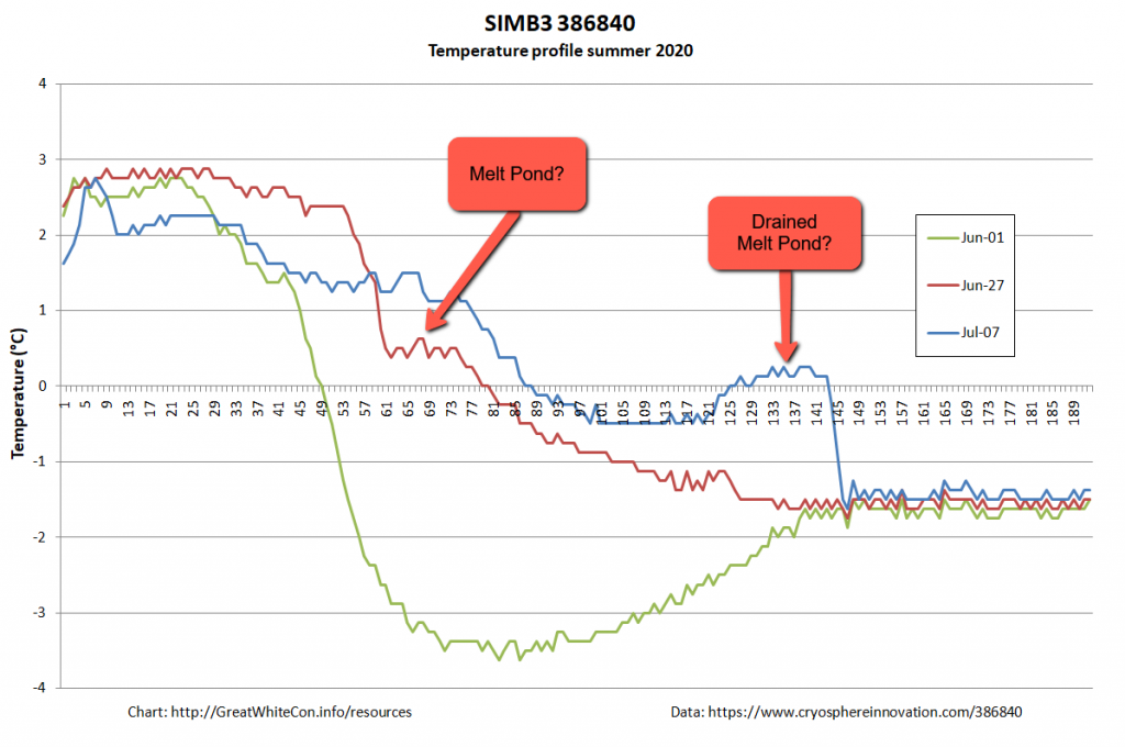
It looks to me as though the ice floe carrying the buoy is currently floating on some warm fresh water from a recently drained melt pond, which is confusing the sensor designed to measure the position of the bottom of the ice. There certainly seems to be far less than the claimed “1.653 m snow and ice thickness” still remaining to be melted!

[Edit – July 15th]

A very unusual image. Hardly a cloud in the sky over the North Pole yesterday:
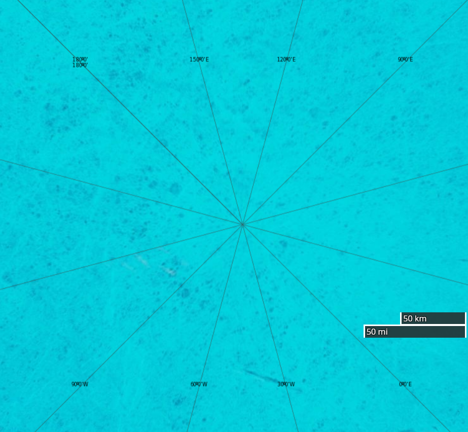
NASA Worldview “false-color” image of the North Pole on July 14th 2020, derived from the MODIS sensor on the Terra satellite

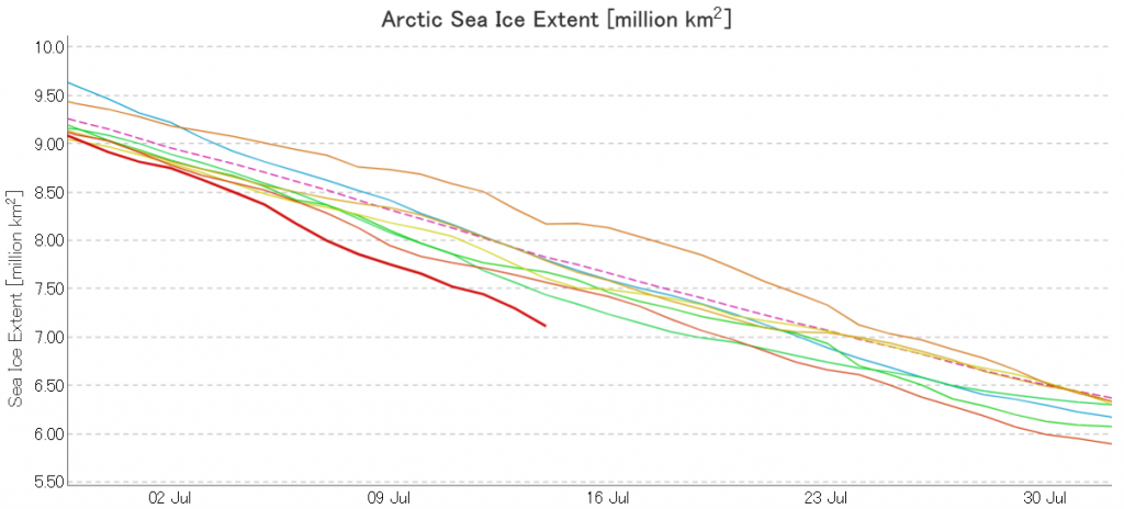
The July 2020 extent “plummet” shows no signs of ending just yet. Here’s the JAXA/ViSHOP version:
[Edit – July 17th]

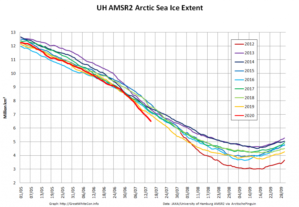
JAXA AMSR2 extent is now below 7 million km², and the high resolution version is lower still:
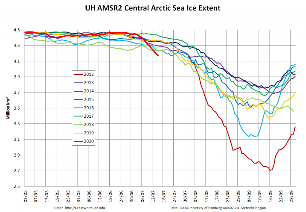
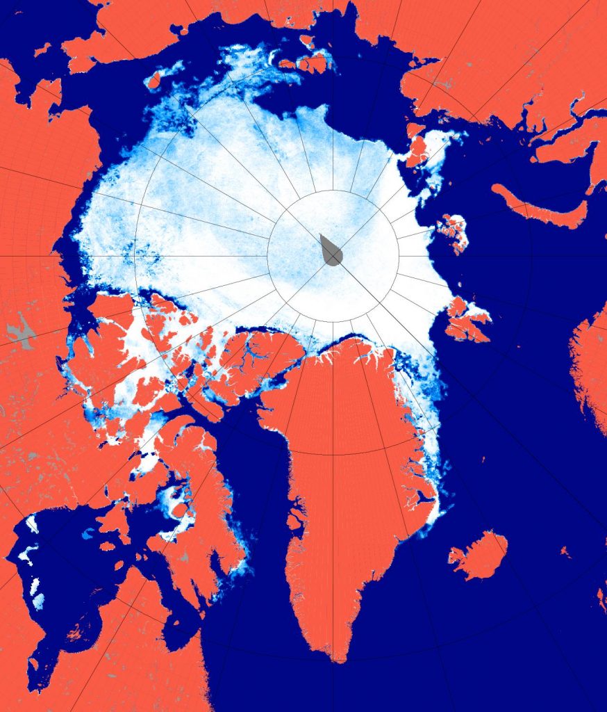
As the “Laptev Bite” and the Atlantic periphery of open water extends further towards the North Pole, Central Arctic Basin extent is now also at record lows for the date in the AMSR2 record:
[Edit – July 19th]

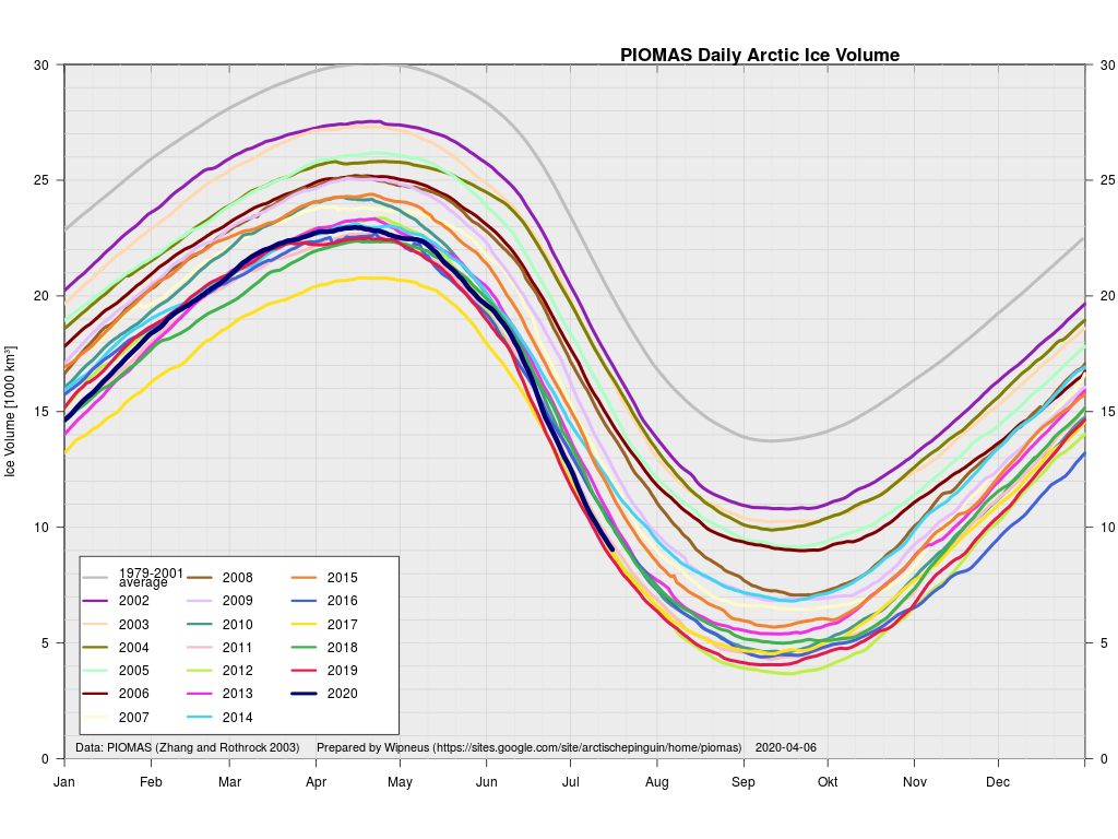
Wipneus has crunched the mid month PIOMAS gridded thickness numbers, and here are the results:
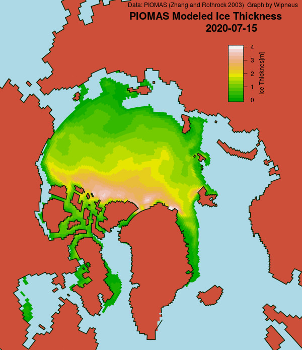
Extent is currently lowest in the satellite era by a long way, but modelled volume is only fourth lowest!

Watch this space!

[Edit – July 21th]

At long last there’s a sub 1000 hPa MSLP low pressure area slowly wending its way across the central Arctic:
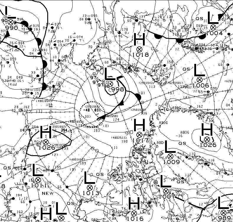
It seems to have bottomed out at 997 hPa. Perhaps this will inhibit the ongoing “plummet” in extent? JAXA extent fell by 114,342 km2 yesterday.

[Edit – July 23rd]

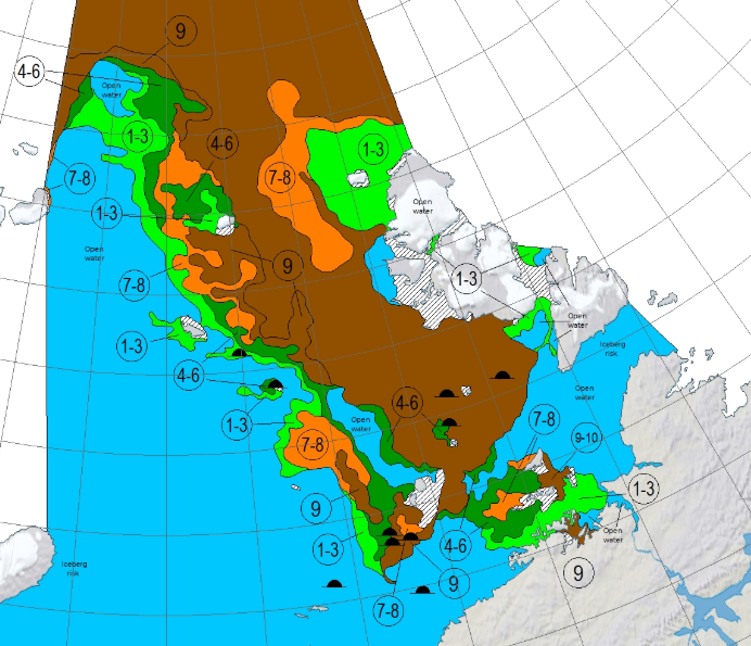
The Northern Sea Route has opened unusually early this year:

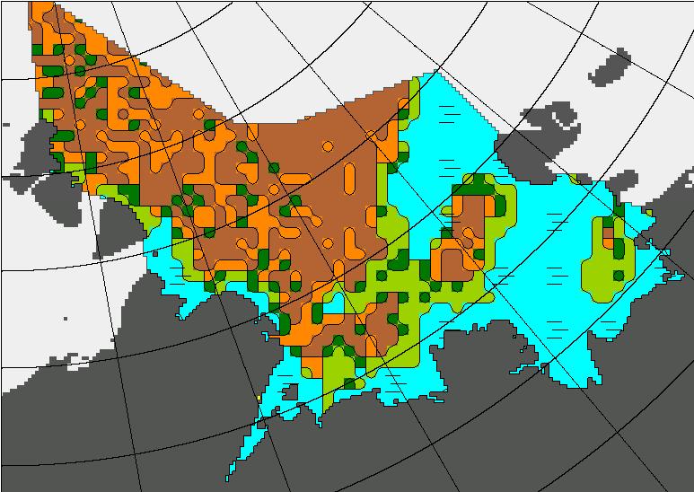
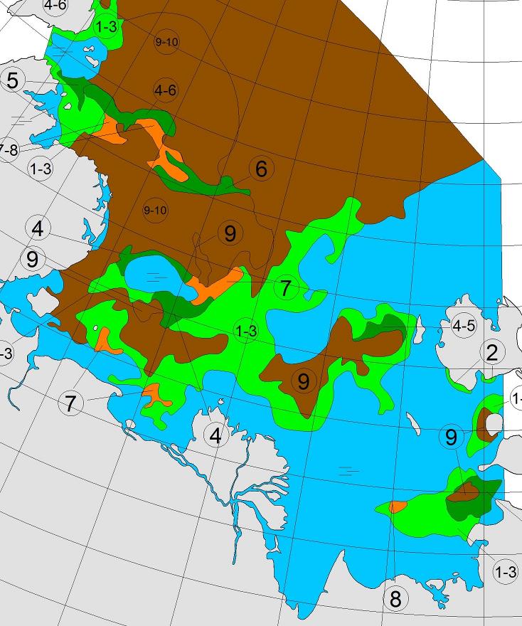
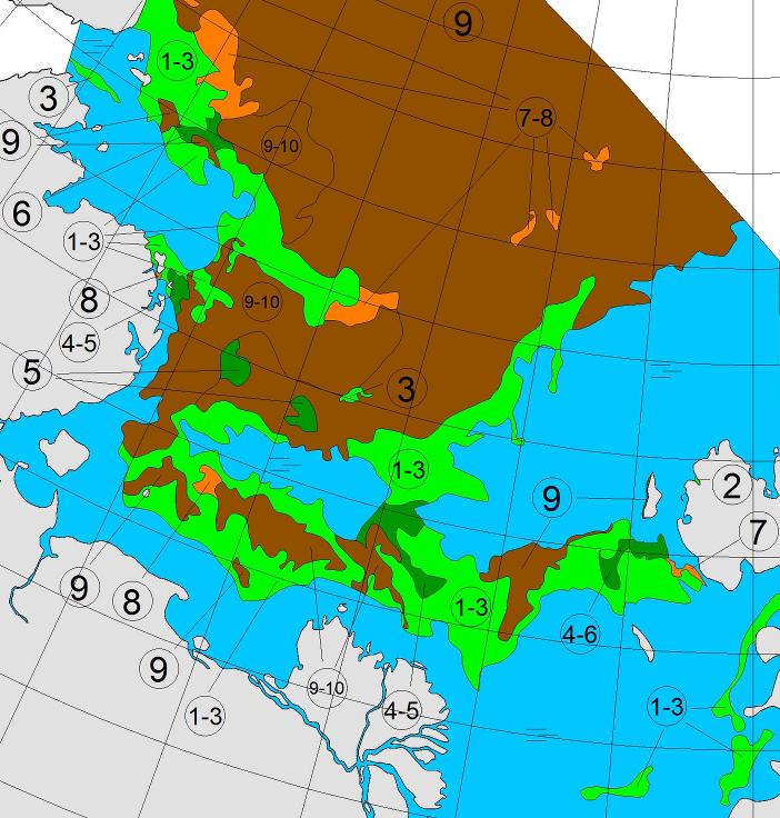
Based on the AMSR2 concentration maps from the University of Hamburg that happened on July 13th. The final choke point, as is so often the case, was the Vilkitsky Strait. According to the charts from the Russian Arctic and Antarctic Research Institute, by the 14th there was a narrow way through occupied by no more than 3/10 concentration ice:
[Edit – July 25th]

A mere three days away, and the GFS and ECMWF forecasts are in agreement, so there is a decent chance this setup will materialise in the real world:
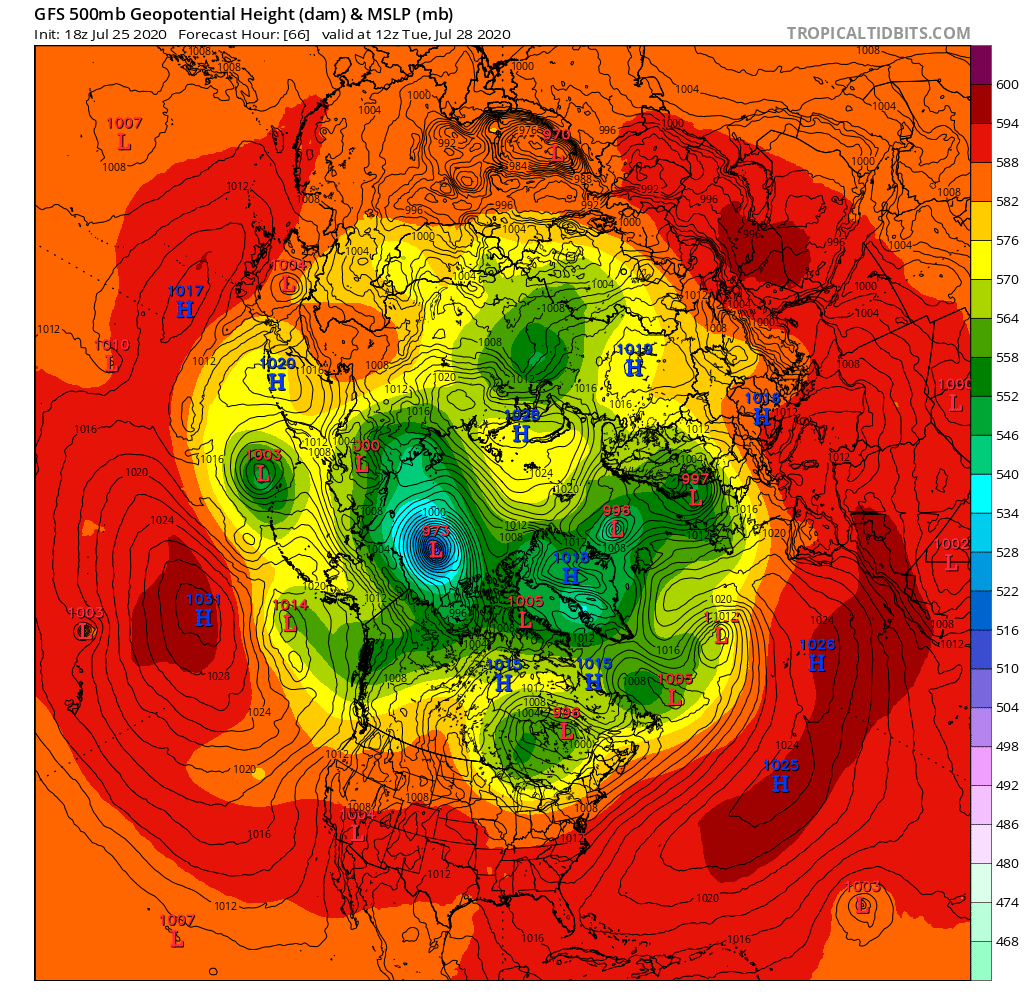
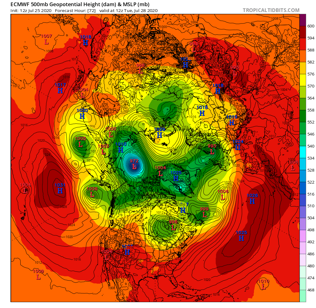
Graphics via Tropical Tidbits

A 972(ish) hPa MSLP cyclone sitting over the ice Beaufort Sea by 12Z on Tuesday.

[Edit – July 27th]

The Sea Ice Prediction Network July forecast for this year’s September minimum extent have been released. Here’s the graphical overview:
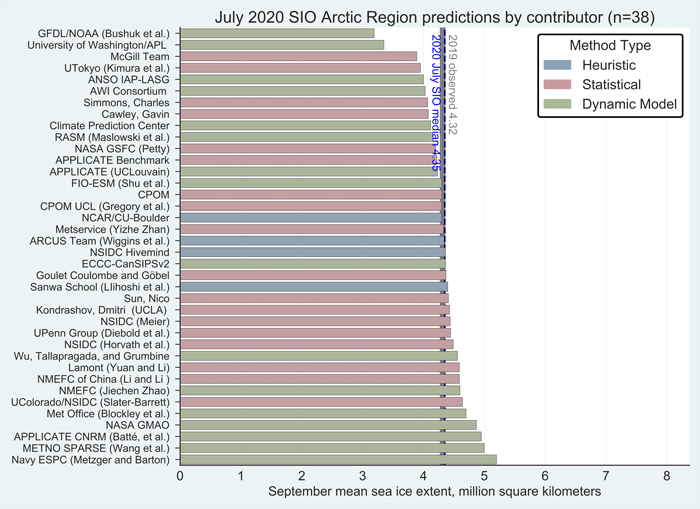
This year’s median projected value from the July forecasts of 4.3 million square kilometers is essentially identical to the median from the June forecasts. Quartiles are 4.1 and 4.6 million square kilometers. As was also the case for June, only two projections, both by dynamic models, are for a new record low, below the mark of 3.57 million square kilometers set in 2012. One dynamical model predicts the September sea-ice extent above 5.0 million square kilometers, compared to two in the June report.

Note that the numbers quoted are for the average NSIDC extent across the month of September, not the lowest daily JAXA extent, which I suggested earlier would be “below 4 million km²” this year.

Meanwhile over on Twitter this evening (UTC):

[Edit – July 28th]

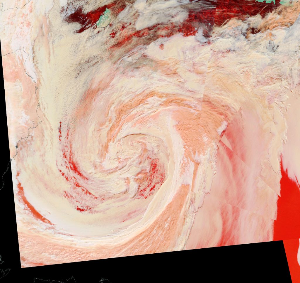
The MSLP of the (Great?) Arctic cyclone sank below 970 hPa overnight:

Here’s an early false colour snapshot of how (s)he looks from on high this afternoon (UTC), courtesy of the MODIS instrument on the Terra satellite:
[Edit – July 29th]

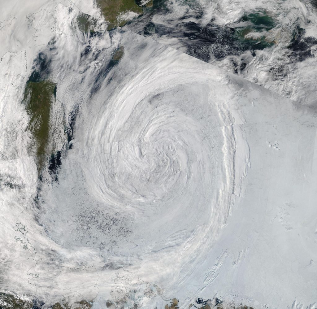
First up today we have a more complete “true colour” image of the cyclone doing its worst yesterday, including a fairly clear view in the bottom left corner of the initial damage to the sea ice covering the eastern Beaufort Sea. This one is from the Aqua satellite:
Watch this space!

Facts About the Arctic in June 2019

In my humble opinion summer in the Arctic summer starts on June 1st, so let’s check the current sea ice situation in the once frozen North. For details of the preconditioning of the ice during the Arctic spring see “Melt Pond May“, where I concluded that:

Compared with 2016 at the same time of year I am compelled to say that with June 1st just around the corner the 2019 summer melting season is primed to progress more quickly.

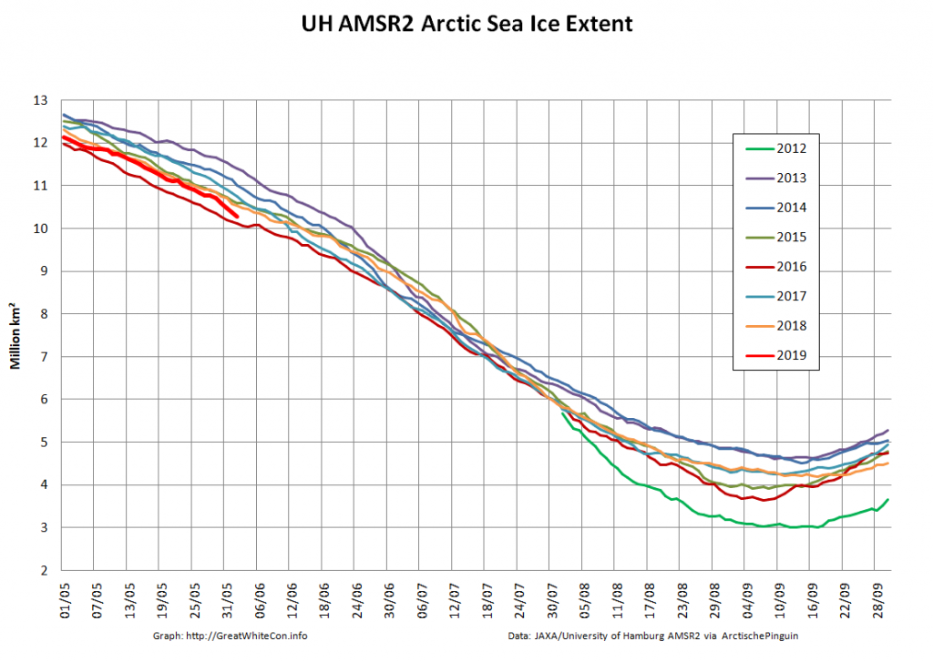
Currently extent is significantly below 2012, albeit somewhat above 2016 at the same time of year. And what of melt ponds? In 2012 there was evidence of less snow cover over land and more surface water on the ice on the Siberian side of the Arctic. Other than that Arctic sea ice in 2019 looks to be in worse shape than in 2012.

And how have things progressed over the last few days? Take a look at this:

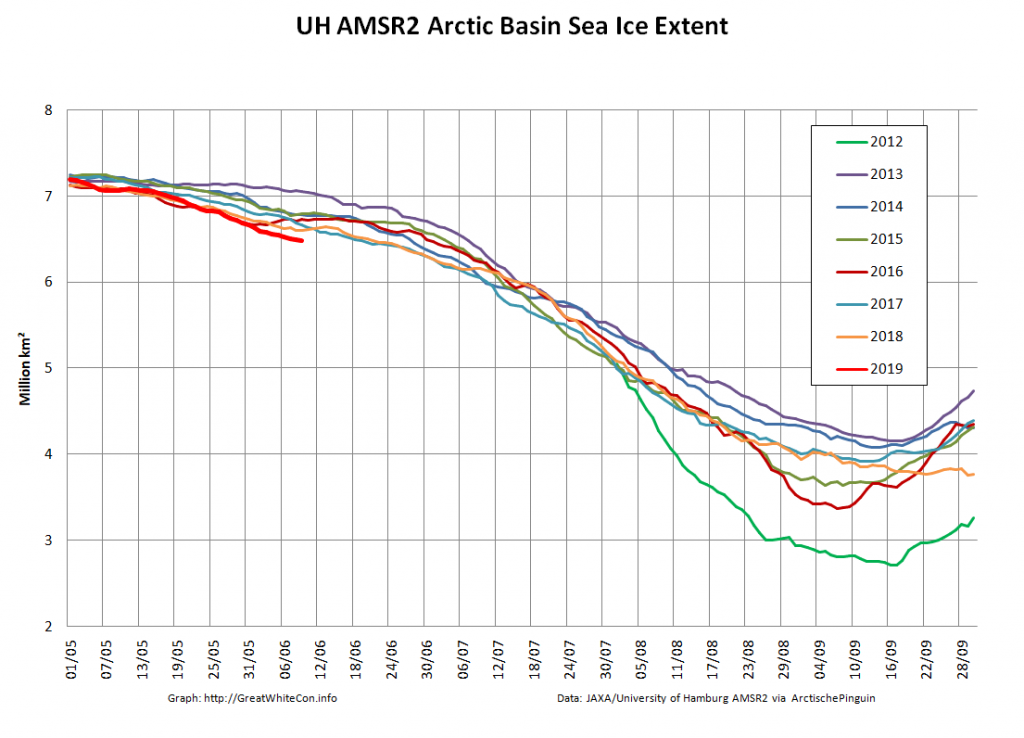
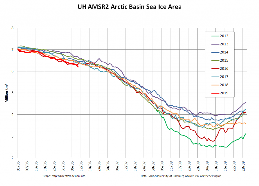
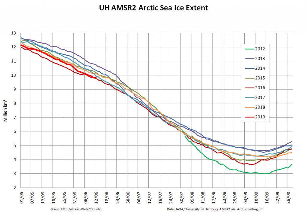
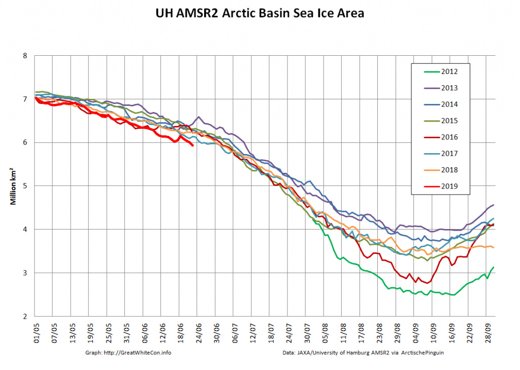
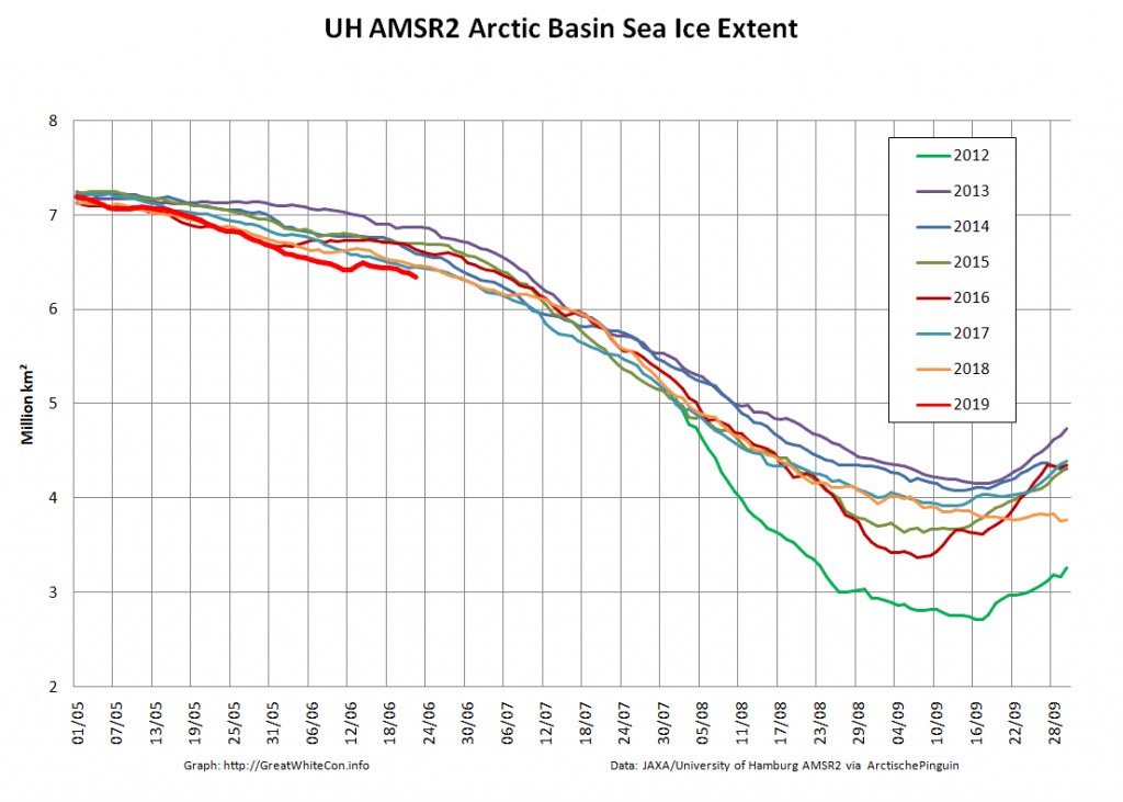
Our “Arctic Basin” metric encompasses the Central Arctic plus the Beaufort, Chukchi, East Siberian and Laptev Seas. It is currently headed into uncharted waters. The effect on overall Arctic sea ice extent is also readily visible:

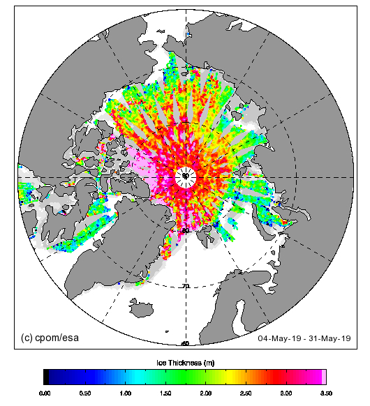
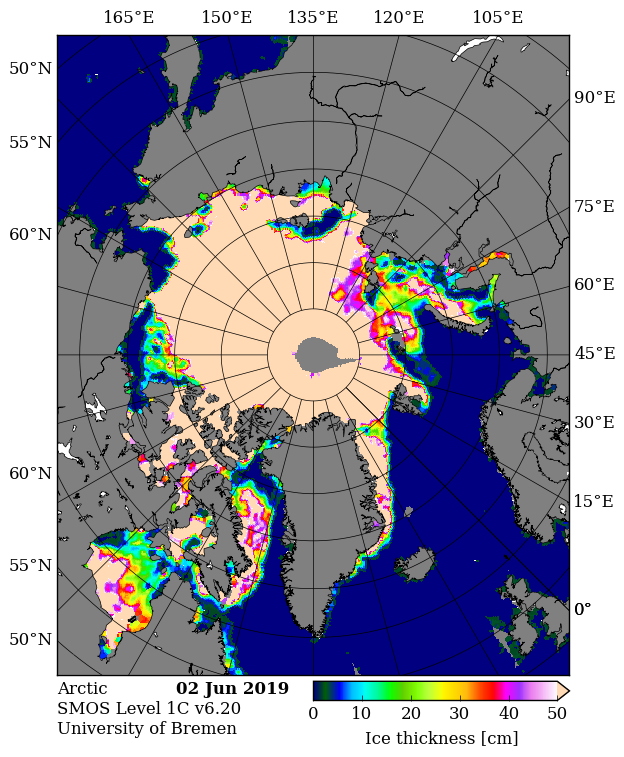
This year both the CPOM version of CryoSat-2 thickness and the University of Bremen’s SMOS thickness maps are continuing to be published during the melting season:

Take them with a large pinch of salt at this time of year!

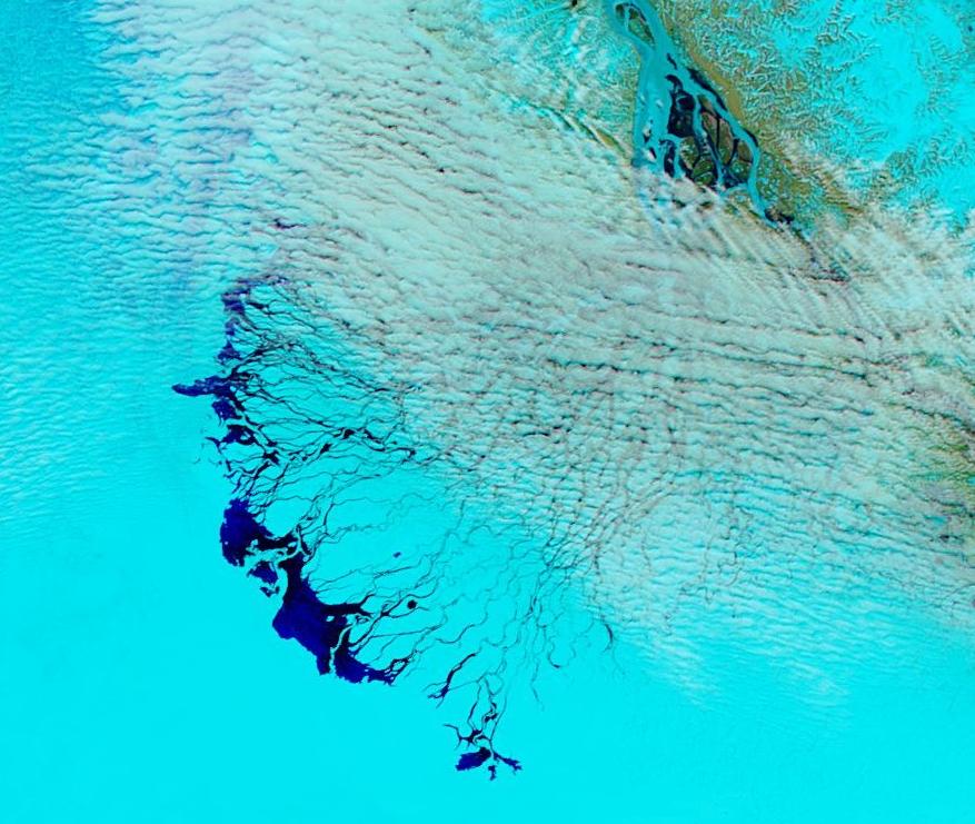
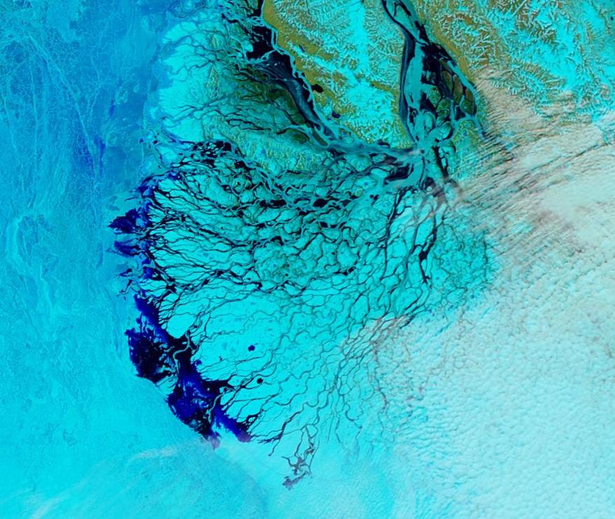
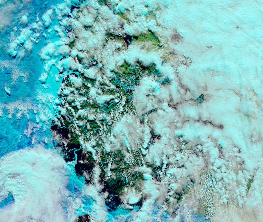
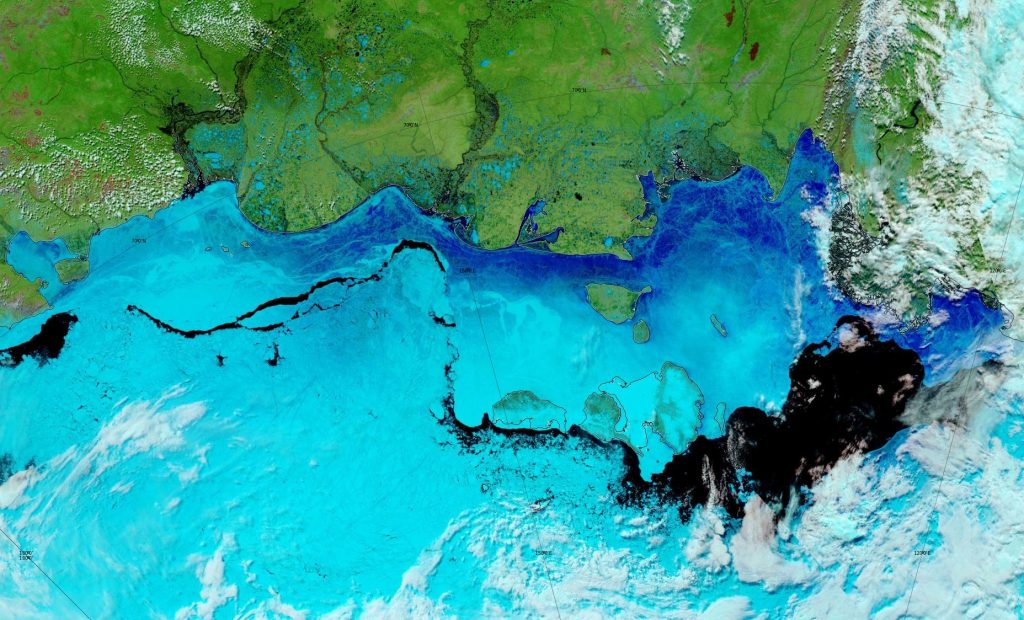
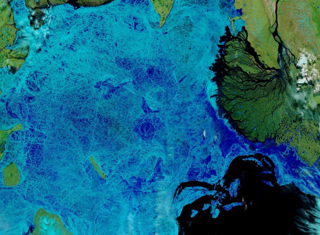
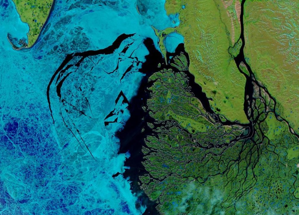
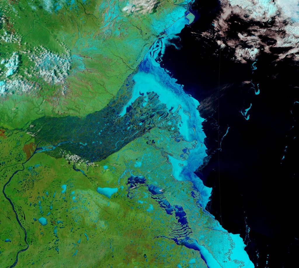
Finally, for the moment at least, liquid water is starting to seep out of the Lena Delta:

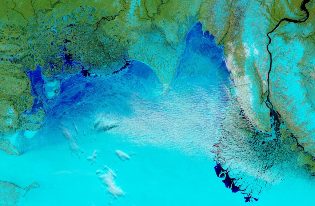
NASA Worldview “false-color” image of the Lena Delta on June 3rd 2019, derived from the MODIS sensor on the Aqua satellite

For comparison purposes please also take a look at the same date in 2016:

NASA Worldview “false-color” image of the Lena Delta on June 3rd 2016, derived from the MODIS sensor on the Aqua satellite

and the previous date in 2012:

NASA Worldview “false-color” image of the Lena Delta on June 2nd 2012, derived from the MODIS sensor on the Aqua satellite

[Edit – June 4th]

A significant area of the Laptev Sea ice is now turning a much darker shade of blue using the band 7-2-1 false colour combination:

NASA Worldview “false-color” image of the Laptev Sea on June 4th 2019, derived from the MODIS sensor on the Terra satellite

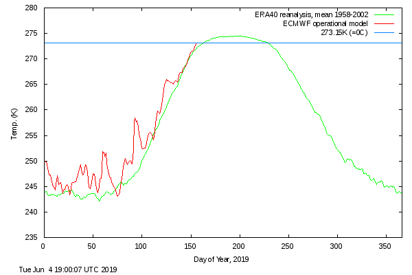
In addition the DMI >80N temperature metric has reached the zero Celsius line well ahead of schedule:

[Edit – June 5th]

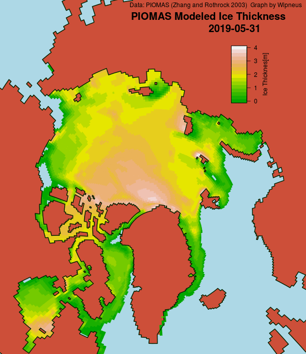
The May PIOMAS numbers have been released! Here is the Wipneus generated state of play on May 31st:

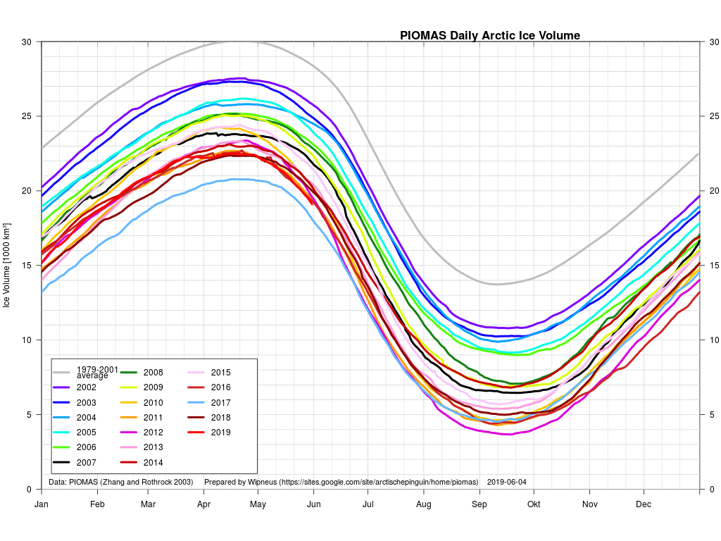
and here is the all too familar multi-year graph:

[Edit – June 10th]

As reported in this year’s Northwest Passage article:

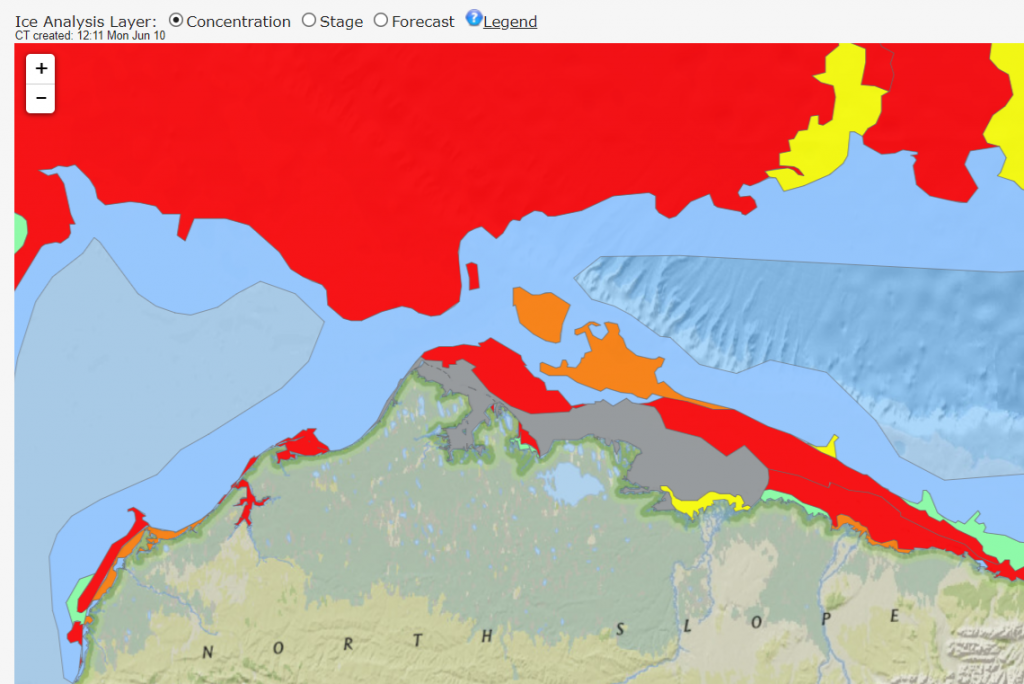
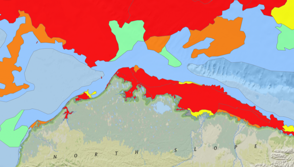
Any early bird traversing the Northwest Passage from west to east could now sail through open water around Point Barrow, along the Alaskan and Canadian coast and into the Amundsen Gulf:

Arctic Basin sea ice extent is still descending through uncharted territory:

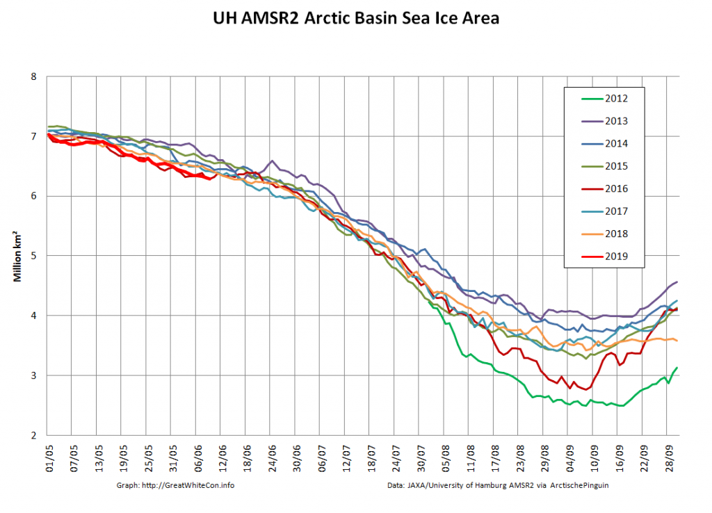
and Basin area currently looks poised to follow suit:

[Edit – June 11th]

There’s a beautifully clear view of the Siberian coast today, with vast areas of melt ponds visible on VIIRS false colour:

NASA Worldview “false-color” image of the Laptev & East Siberian Seas on June 11th 2019, derived from the VIIRS sensor on the Suomi satellite

The Arctic Basin area has indeed taken a nosedive into uncharted territory:

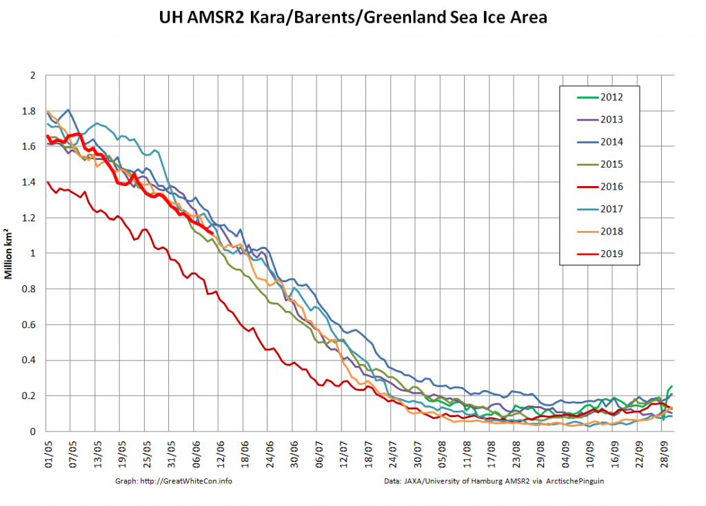
By way of comparison sea ice area on the Atlantic periphery is in amongst the recent pack, thanks to the almost continual drift in that direction over last winter:

[Edit – June 13th]

High resolution AMSR2 extent has been in a “statistical tie” with 2016 for a few days:

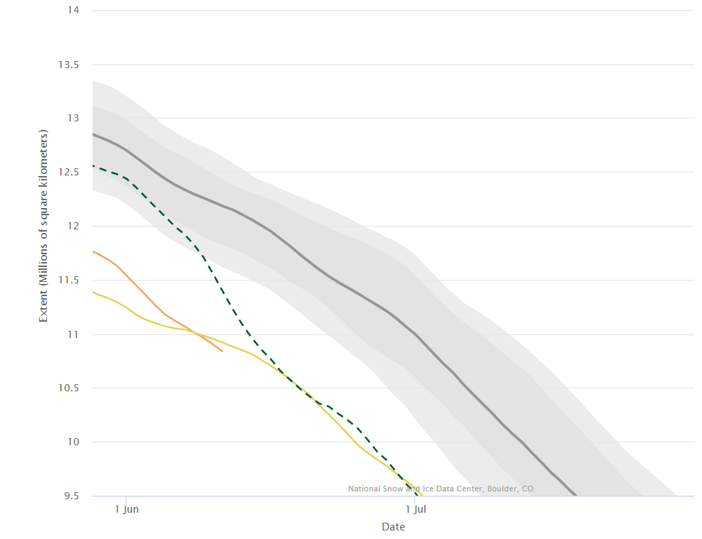
However the NSIDC’s 5 day average extent has reached a clear new low for the date, in the satellite record at least:

[Edit – June 14th]

Especially for AJBT, here’s the Slater Probabilistic Ice Extent prediction for August 3rd:

and here’s the current DMI >80N temperature graph:

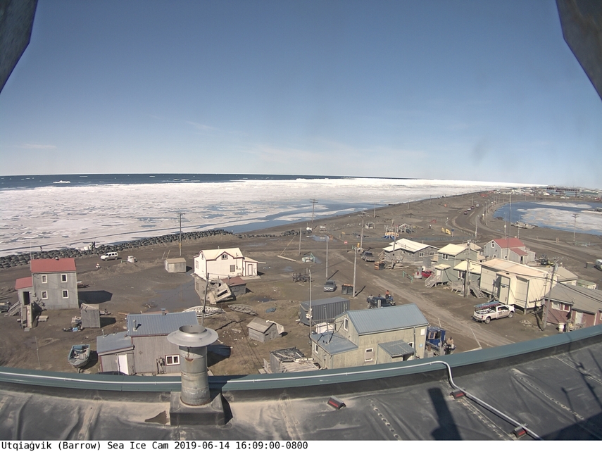
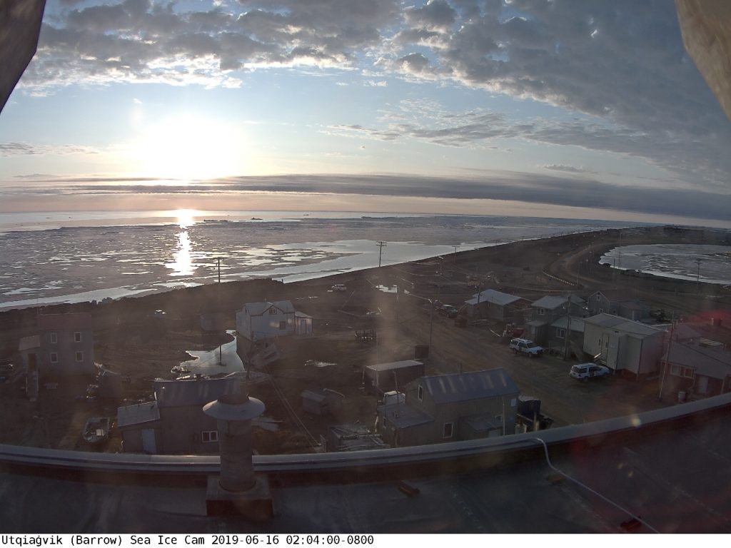
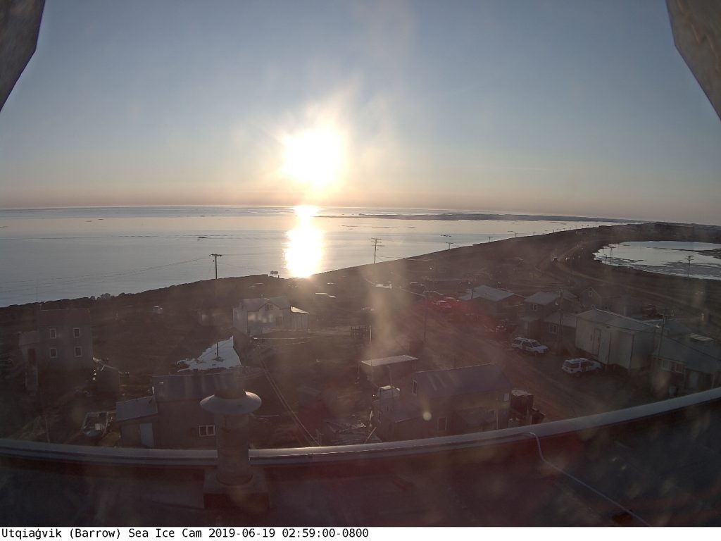
Finally, for the moment at least, there is not very much fast ice left at Utqiaġvik:

[Edit – June 15th]

The sea ice in the Laptev Sea is starting to break up:

NASA Worldview “false-color” image of the Laptev Sea on June 15th 2019, derived from the MODIS sensor on the Terra satellite

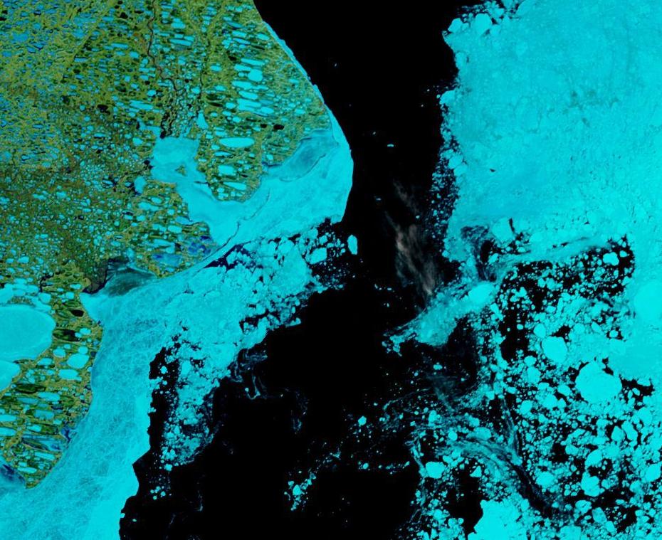
As is the fast ice in the Beaufort Sea:

NASA Worldview “false-color” image of the Beaufort Sea on June 14th 2019, derived from the MODIS sensor on the Terra satellite

Meanwhile the MSLP of the cyclone currently spinning over Severnaya Zemlya was down to 976 hPa at 06:00 UTC this morning:

NASA Worldview “false-color” image of the Kara Sea on June 15th 2019, derived from the MODIS sensor on the Terra satellite

An early morning image from the Utqiaġvik webcam:

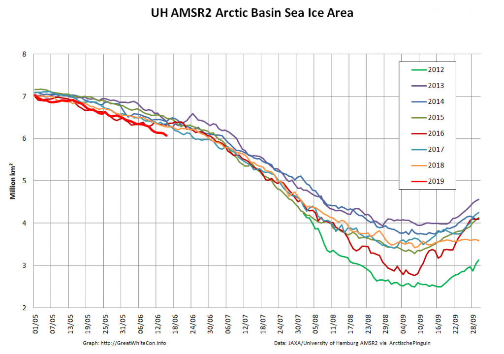
Especially for Mateo (see below) here’s the current high resolution Arctic Basin sea ice area:

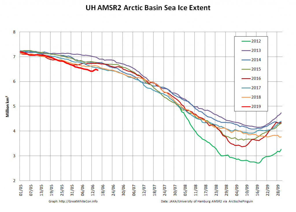
and extent:

Note that the recent cyclones have caused a temporary jump in sea ice extent, but not in area.

[Edit – June 17th]

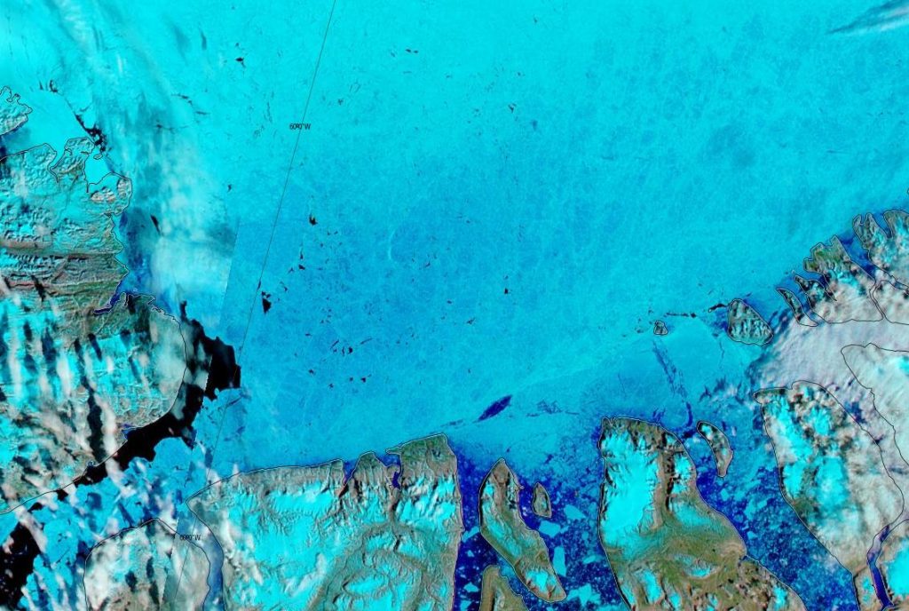
The Lincoln Sea has turned noticeably bluer on MODIS bands 7-2-1 false colour:

NASA Worldview “false-color” image of the Lincoln Sea on June 17th 2019, derived from the MODIS sensor on the Aqua satellite

[Edit – June 19th]

The sea ice off the Lena Delta has started to collapse:

NASA Worldview “false-color” image of the Laptev Sea on June 19th 2019, derived from the MODIS sensor on the Aqua satellite

Meanwhile the clear water off Point Barrow is opening up further:

Finally, for the moment at least, here is the current view from the Utqiaġvik (Barrow as was) sea ice webcam:

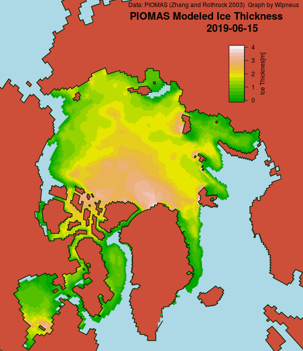
P.S. The mid month PIOMAS numbers have been released, and Wipneus has worked his usual magic:

2019 sea ice volume is currently in a “statistical tie” with 2012, in 2nd place behind 2017:

[Edit – June 22nd]

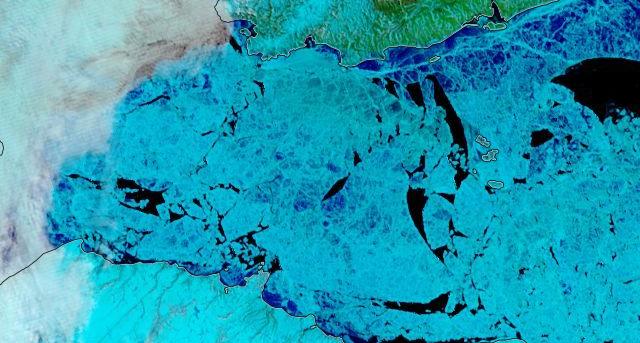
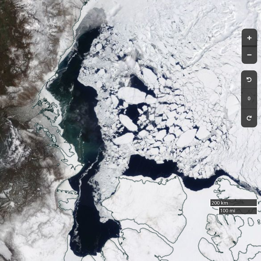
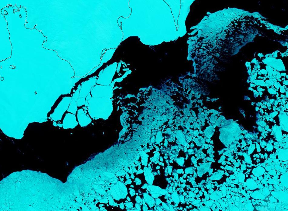
The fast ice in the Vilkitsky Strait has started to break up:

NASA Worldview “false-color” image of the Vilkitsky Strait on June 22nd 2019, derived from the MODIS sensor on the Terra satellite

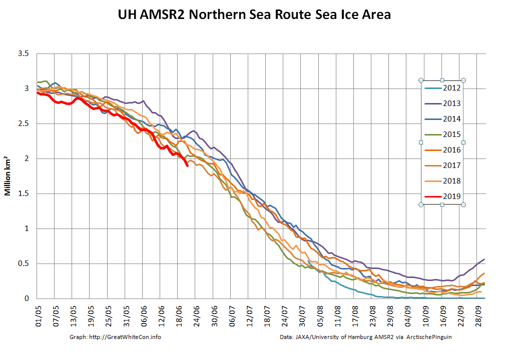
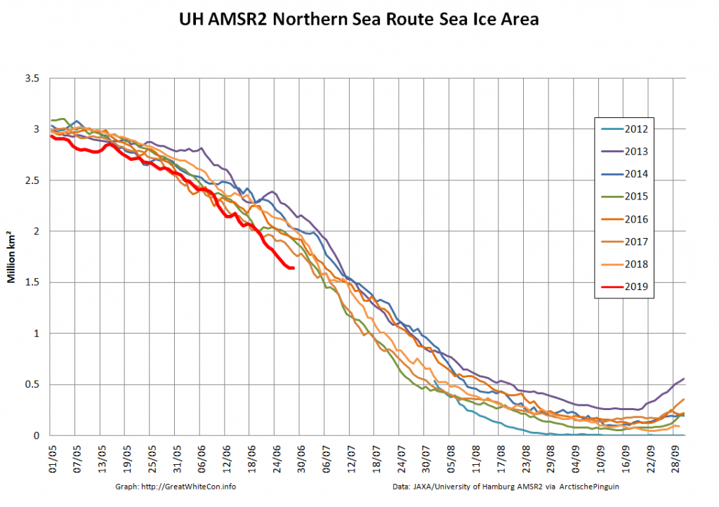
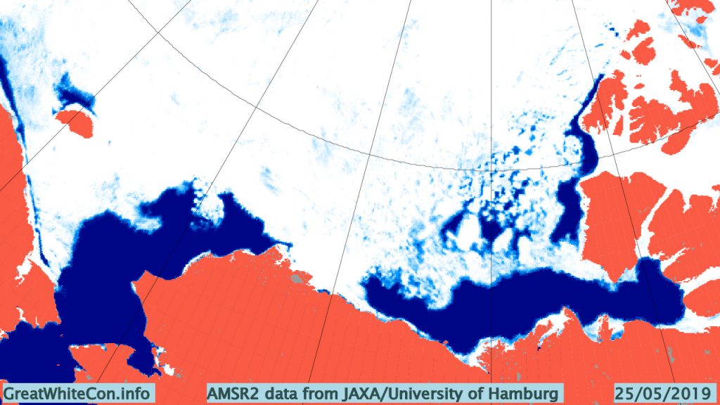
Sea Ice area along the Northern Sea Route is currently the lowest for the date in the AMSR2 ere:

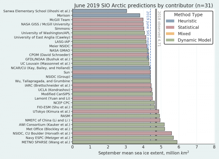
In addition the June 2019 Sea Ice Prediction Network report has been released. Here’s the summary:

Again, as in previous years, the spread in the dynamical models are larger compared with statistical models. Overall, the heuristic method has the lowest projected September sea-ice extent value with a median at 4.09 million square kilometers, and the dynamical models have the highest number with the median at 4.56 million square kilometers.

[Edit – June 23rd]

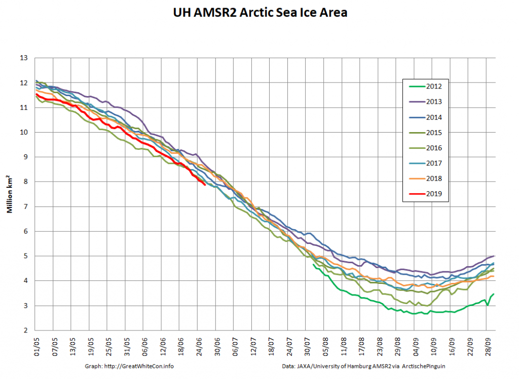
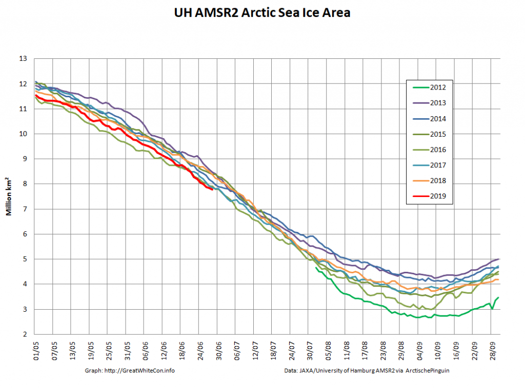
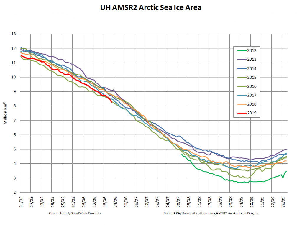
Arctic wide sea ice area is now lowest for the date in the high resolution AMSR2 record, although extent has yet to follow suit:

If you exclude the peripheral seas, which are all largely ice free by mid September in this day and age, the picture is extremely stark:

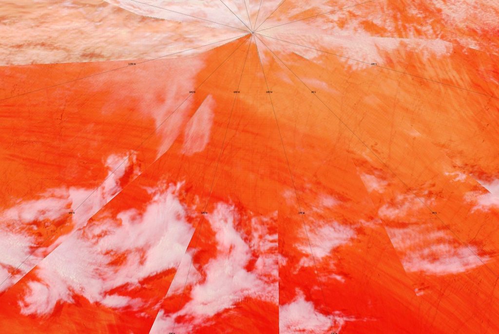
A brief glimpse through the clouds reveals that the North Pole is now starting to feel the recent heat:

NASA Worldview “false-color” image of the North Pole on June 22nd 2019, derived from the MODIS sensor on the Terra satellite

[Edit – June 27th]

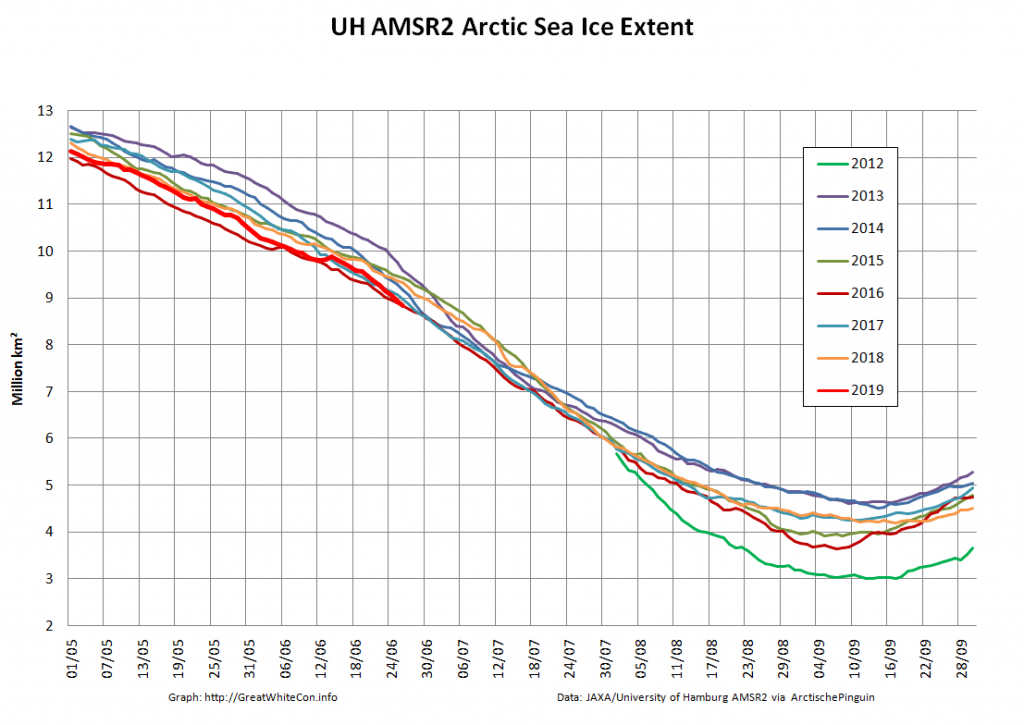
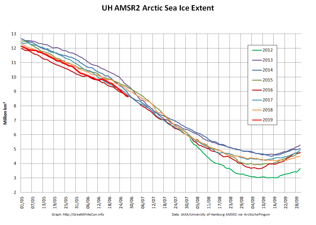
Arctic wide sea ice extent is now lowest for the date in the high resolution AMSR2 record:

Here’s Arctic wide sea ice area, which is still well below the rest of the pack:

[Edit – June 29th]

As the end of the month draws near let’s take a look at sea ice area along a couple of the famous sea routes above the Arctic Circle. First of all here’s the Northern Sea Route, comprising the Kara, Laptev, East Siberian and Chukchi Seas:

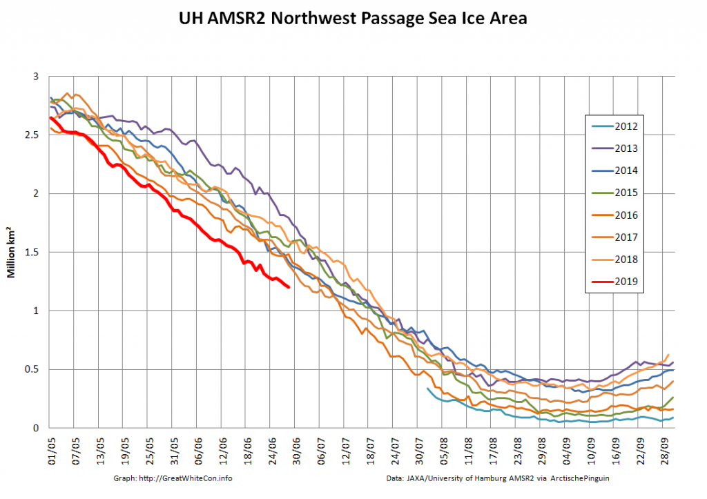
Next here’s the Northwest Passage, comprising the Chukchi and Beaufort Seas plus the channels of the Canadian Arctic Archipelago and Baffin Bay:

For completeness here too are the current Arctic wide area and extent numbers:

Watch this space!
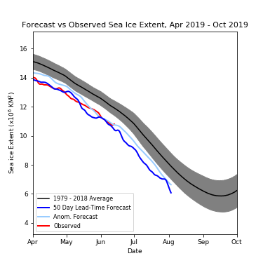
Melt Pond May 2019

A couple of years ago I was asked to provide “a handful of things [you] will be keeping an eye on over the next few months to judge how ‘good’ or ‘bad’ the melt is going?”

My answer was, and remains:

5 fingers worth to start with? Not necessarily in order of time or importance!

1. How soon melt ponds and/or open water hang around in the Beaufort Sea this year. Things started very early [in 2016]:

https://GreatWhiteCon.info/2016/04/the-beaufort-gyre-goes-into-overdrive/

2. Ditto the Bering Strait and Chukchi Sea

3. Ditto the Laptev and East Siberian Seas

4. How many (and how deep, warm, wet) spring cyclones spin around the Arctic Ocean

5. How the snow melt progresses across Canada, Alaska and Siberia

Applying the same criteria this year, open water is already hanging around in the Beaufort Sea, as well as the Amundsen Gulf:

NASA Worldview “true-color” image of the Beaufort Sea on May 21st 2019, derived from the MODIS sensor on the Terra satellite

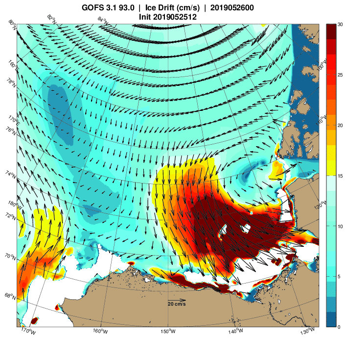
What’s more a cyclone is currently spinning in the area too:

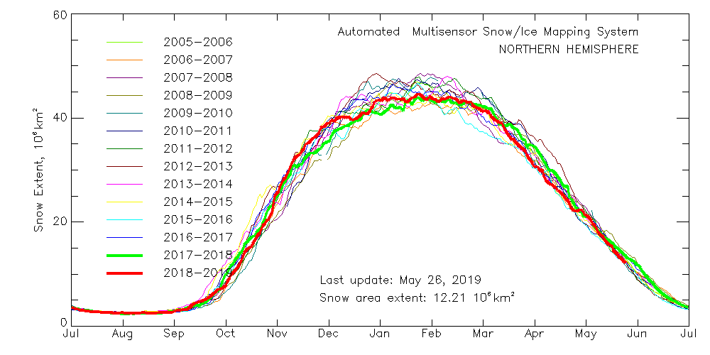
With those prerequisites in place, how about my other criteria? Here’s the current northern hemisphere snow cover graph:

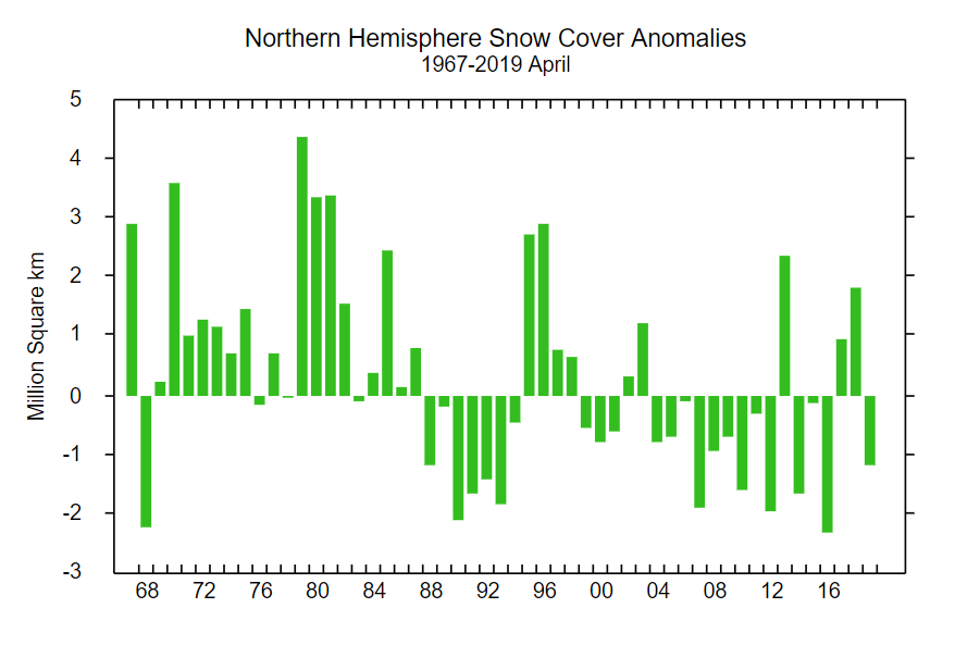
That suggests snow cover over land is close to recent lows, which is confirmed by the Rutgers University snow cover anomaly graph for April:

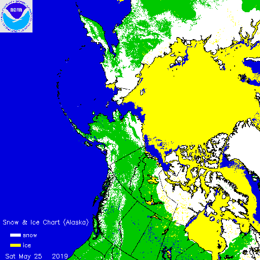
This year is anomalously low, but not by as much as 2012 and 2016. For completeness, here also is the current US National Ice Center snow cover map:

Moving on to melt ponds, there are plenty to be seen on the fast ice around the Mackenzie river delta:

NASA Worldview “false-color” image of the Mackenzie Delta on May 24th 2019, derived from the MODIS sensor on the Terra satellite

There also seem to be signs of some at a higher latitude off Ostrov Kotelny in the New Siberian Islands:

NASA Worldview “false-color” image of the Laptev Sea on May 23rd 2019, derived from the MODIS sensor on the Terra satellite

This year there is also a lot of open water in the Chukchi Sea, and almost no sea ice left in the Bering Sea:

Compared with 2016 at the same time of year I am compelled to say that with June 1st just around the corner the 2019 summer melting season is primed to progress more quickly.

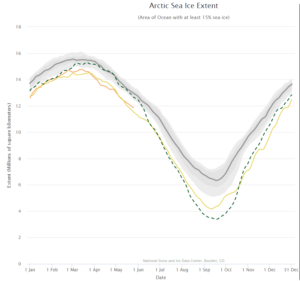
The next obvious comparison to make is with the (in)famous year of 2012, which resulted in the lowest ever minimum extent in the satellite record. Firstly let’s look at the National Snow and Ice Data Center’s graph of Arctic sea ice extent:

Currently extent is significantly below 2012, albeit somewhat above 2016 at the same time of year. And what of melt ponds? In 2012 there was evidence of less snow cover over land and more surface water on the ice on the Siberian side of the Arctic:

NASA Worldview “false-color” image of the Eastern Arctic on May 25th 2012, derived from the MODIS sensor on the Terra satellite

Other than that Arctic sea ice in 2019 looks to be in worse shape than in 2012.

[Edit – May 27th]

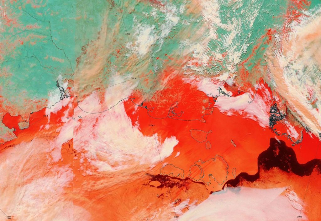
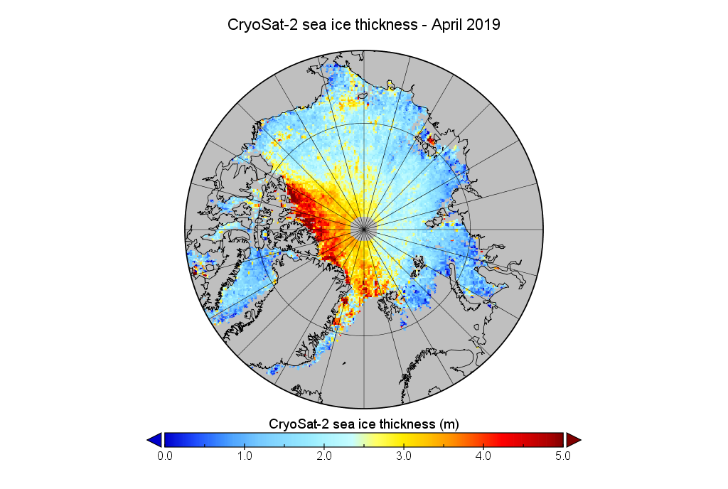
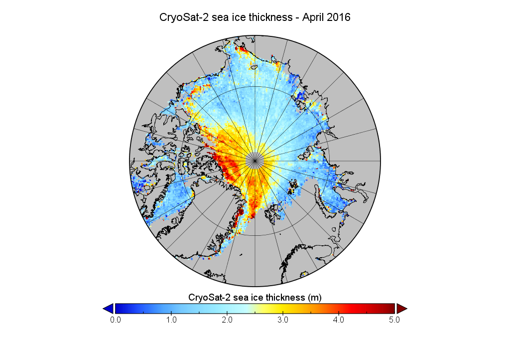
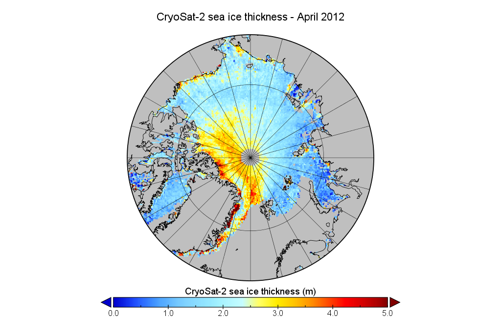
We’ve established that the extent of Arctic sea ice at the end of May 2019 is less than in 2012, but something else to consider is whether that ice is currently thicker than in 2012, or not. Satellites can have a reasonable stab at measuring the area of sea ice, but the third dimension is much trickier. The European Space Agency’s CryoSat-2 satellite has been attempting to measure sea ice thickness since 2010, so let’s take at the conclusions it has reached:

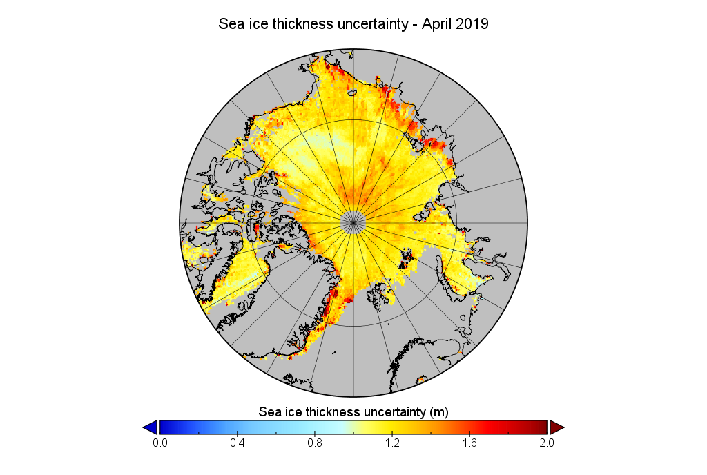
Don’t forget to take a good long look at the associated uncertainties too:

Watch this space!

Northabout Meets Some Serious Sea Ice

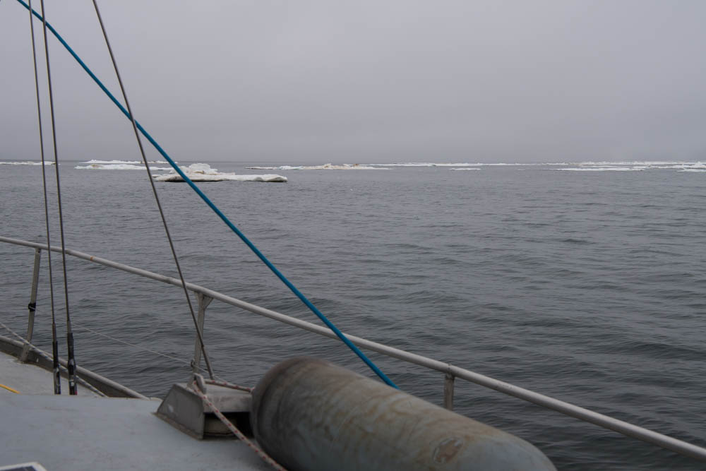
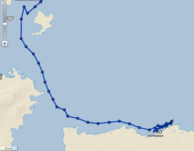
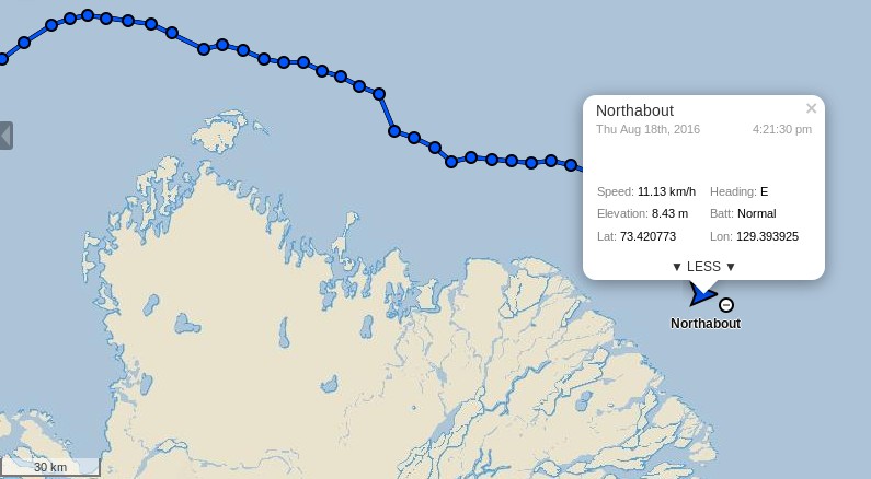
Having rounded Cape Chelyuskin yesterday Northabout has now come across some serious sea ice in the Laptev Sea. The crew are posting regular updates on conditions. Here’s a recent example:

DSC_1030

Having anchored against some land-fast ice overnight Northabout is on the move once again:

Northabout-20160810

Not before indulging in some strenuous early morning exercise though!


[Edit – August 11th]

Northabout made further progress yesterday and anchored last night in the shelter of Ostrov Volodarskiy:

Northabout-20160811

There seems to have been less sea ice in attendance than the night before!
Northabout-Anchorage-20160810

Northabout is now approaching the area in which the most recent AARI forecast suggests there will be sea ice all the way to the coast:

ICEFRC_LAP_20160809_72

Will the hoped for winds have done their work by tomorrow?


[Edit – August 13th]

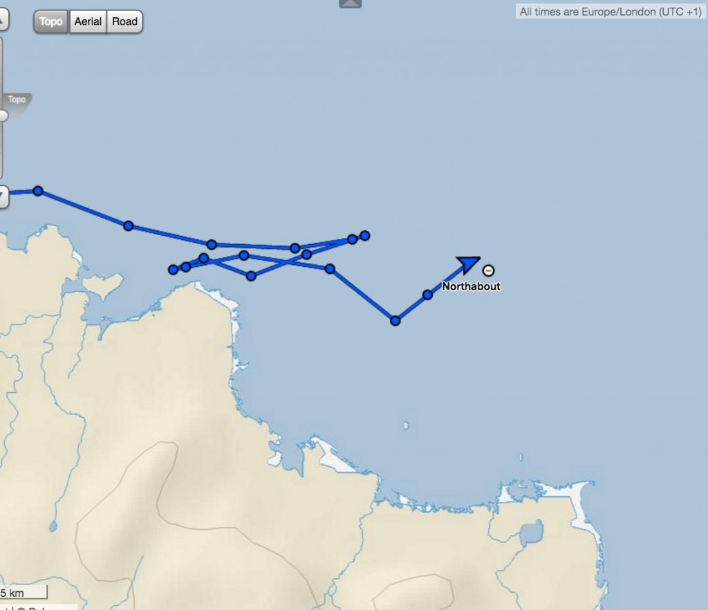
Northabout spent yesterday trying to find a way south. Ultimately they failed, reporting that:

The wind and sea state were really picking up. Our options were few. Wind and tide against us, really shallow water of 5m , small bergy bits in the water to miss. NO shelter whatsoever. Do we make our way back the 40 miles where we knew a good anchor spot ? At this rate it would take us 11 hours, using up precious diesel. In the end a nice large floe came into sight, so we gingerly approached, and my comrades made the boat secure. It would protect us from the sea state like a pontoon, and protect us from the mass of ice coming our way. My watch finishes at 12 and I got into my pit at 3.30am.

To our surprise, the floe was moving at 1.3 knots, so up again to move. The strong winds were driving huge belts of pack ice our way, we didn’t want to be caught up against the shore. So, off towards our anchorage, and then a nice large ‘Stamukha’ appeared. Russian for ice that has grounded on the bottom, so not moving. Another mooring. This time it felt safe, so a good couple of hours sleep,

This morning it looks like they are still anchored to that Stamukha:

Northabout-20160813-1000

Here’s a picture of their anchorage the previous night:

and moving pictures of Northabout mooring to the “stamukha”.

Here’s the latest AARI sea ice chart:

AARI-Laptev-20160812

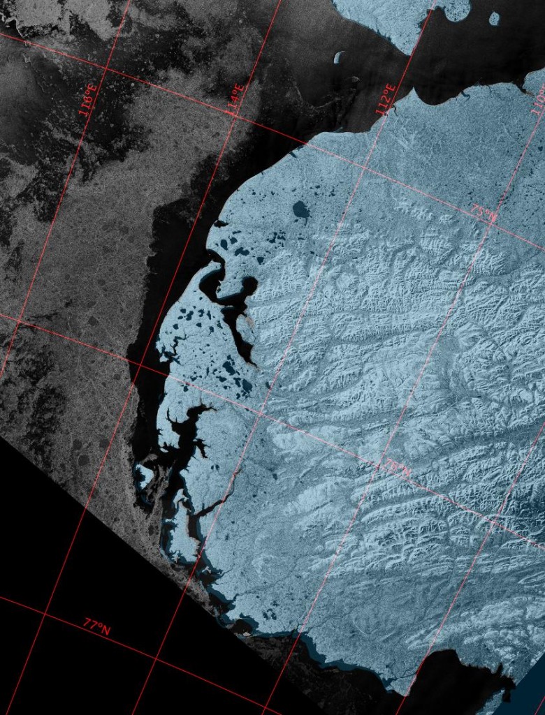
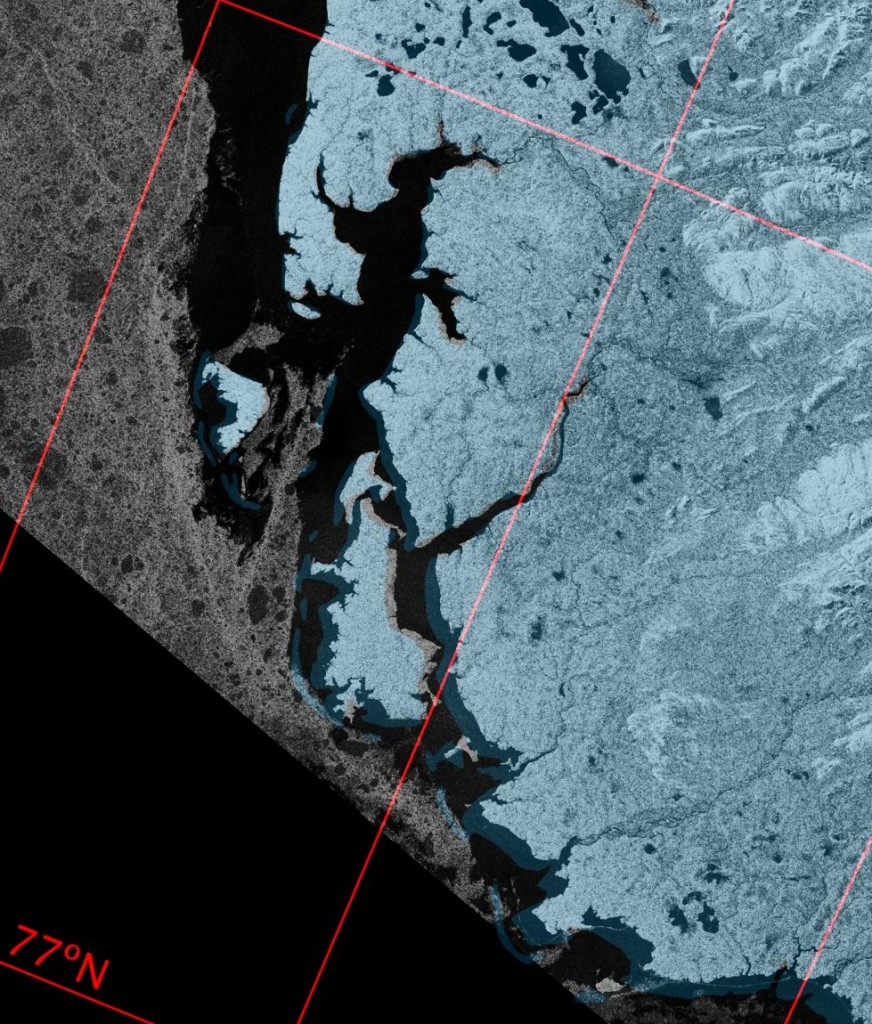
which still shows a considerable length of the coast of the Taymyr Peninsula beset by 9/10 concentration sea ice. However Sentinel 1A imaged that coast just before midnight last night. Here’s what it revealed:

S1A_20160812T233250_Overview

S1A_20160812T233250_Closeup

So near and yet still so far for Northabout?


[Edit – August 13th PM]

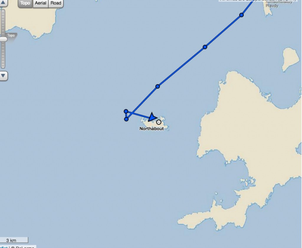
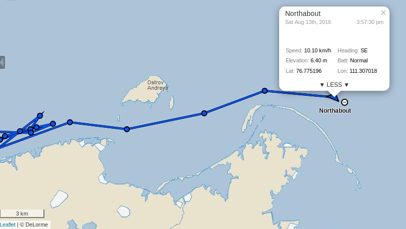
Stop Press! Northabout has now passed Ostrov Andreya and turned south:
Northabout-20160813-1600

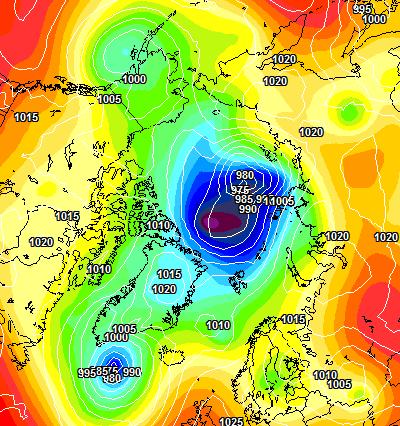
If last night’s Sentinel 1A images are to be believed the worst is now behind the Polar Ocean Challenge team, until the winds of the forthcoming “Great Arctic Cyclone” of 2016 arrive at least? Here’s the current ECMWF forecast for early Monday morning, courtesy of MeteoCiel:

ECMWF-20160813+48


[Edit – August 14th]

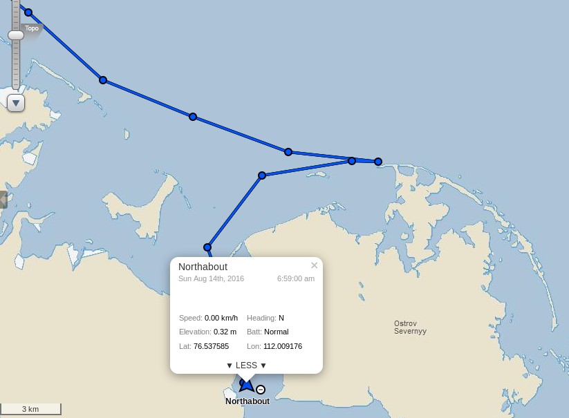
After inspecting a possible route to the east of Ostrov Severnyy, the crew of Northabout have decided that:

We have had to go and find shelter tonight. A huge storm on the way, and high wind, in shallow waters with masses of ice driving your way, is no place to hang around to see what might happen.

So, now at anchor, all tired, excited after today, and looking forward to the next hurdle – I think! As I write, the wind is gusting 30 knots, so clever to run for shelter.
Northabout-20160814-1000


[Edit – August 15th]

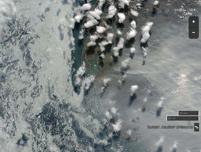
The Sentinel image from last night isn’t very clear, and today’s MODIS images are rather cloudy so here’s one from yesterday:

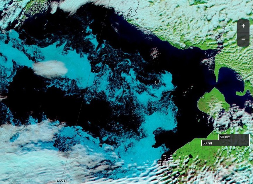
NASA Worldview “true-color” image of the western Laptev Sea on August 14th 2016, derived from the MODIS sensor on the Aqua satellite

It shows that the winds had already opened up a fairly ice free channel past Ostrov Severnyy, and also the smoke that Northabout’s crew reported smelling yesterday:

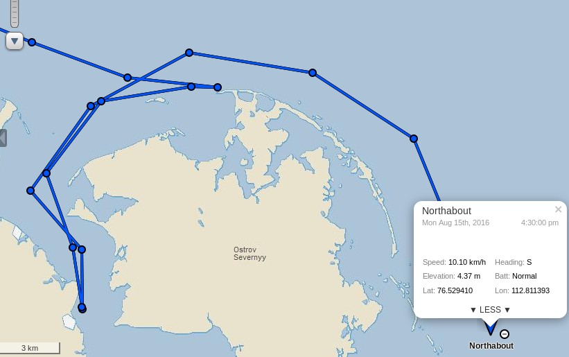
Staying at Anchor for another night behind Ostrov Severnyy – Air 9C water 5C 76 53N 112 E 30 knot winds from SW 15.40 UTC 22.40 local time

Well, as predicted from the Grib files, winds slowly increased throughout last night to 35 and gusting much higher. Also, as predicted, the temp rose to an amazing 17 degrees today! In the morning, I also got the distinct smell of wood smoke. Maybe a forest fire 500 miles south and the smell drifted with the wind. At one point, we slipped the anchor, so good we had an anchor watch and wise to find shelter, no ice, 7m of depth, surrounded by land but still bouncing about like a cork.

In the wake of the cyclone they are sailing south again today, apparently unhindered by sea ice:

Northabout-20160815-1630


[Edit – August 16th]

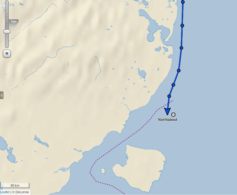
Northabout has made good progress overnight:

Northabout-20160816-1130

The skies are clear this morning over the south-west Laptev Sea:

NASA Worldview “false-color” image of the south-western Laptev Sea on August 16th 2016, derived from the MODIS sensor on the Terra satellite

The next question is which side of Ostrov Bol’shoy Begichev will Northabout pass? All the indications are that the answer will be to the east.

Whilst we wait for that to be confirmed, here is some video footage of Northabout passing Ostrov Andreya on August 13th:

P.S. Here’s the latest AARI ice chart for the Laptev Sea:

AARI-Laptev-20160815


[Edit – August 18th]

Northabout has encountered yet more sea ice. According to the “Crew Blog” of Ben Edwards:

Over night we’d sailed into ice. I know, I said we shouldn’t be troubled by ice for a bit, I was wrong. The ice on its own wasn’t too bad, the thing was we had fog as well. The fog was terrible, we could barely see five meters in front of the prow and the ice just kept on coming. After a bit the fog went, thankfully, the ice didn’t. Eight hours later when I’m back on watch we still had ice and even better, we had to divert to avoid a sandbank. Then the fog came back, typical. Luckily after another two and a half hours the ice began to clear a bit, for now.

Despite the ice, fog and sandbank Northabout is still making good progress across the Laptev Sea, and is currently sailing past the delta of the Lena River:

Northabout-20160818-1630


Previous Polar Ocean Challenge articles:

Non Fiction:

Northabout Bides Her Time

Northabout’s Great Adventure

Fiction:

Is the Polar Ocean Challenge About to End in Disaster?

The Beaufort Gyre Goes Into Overdrive

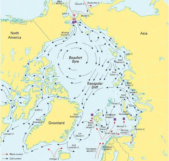
According to the US National Snow and Ice Data Center, the Beaufort Gyre is:

A clockwise circulation (looking from above the North Pole) in the Beaufort Sea, north of Alaska. This circulation results from an average high-pressure system that spawns winds over the region.

beaufort_gyre

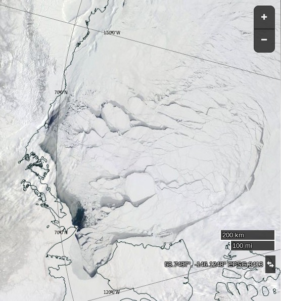
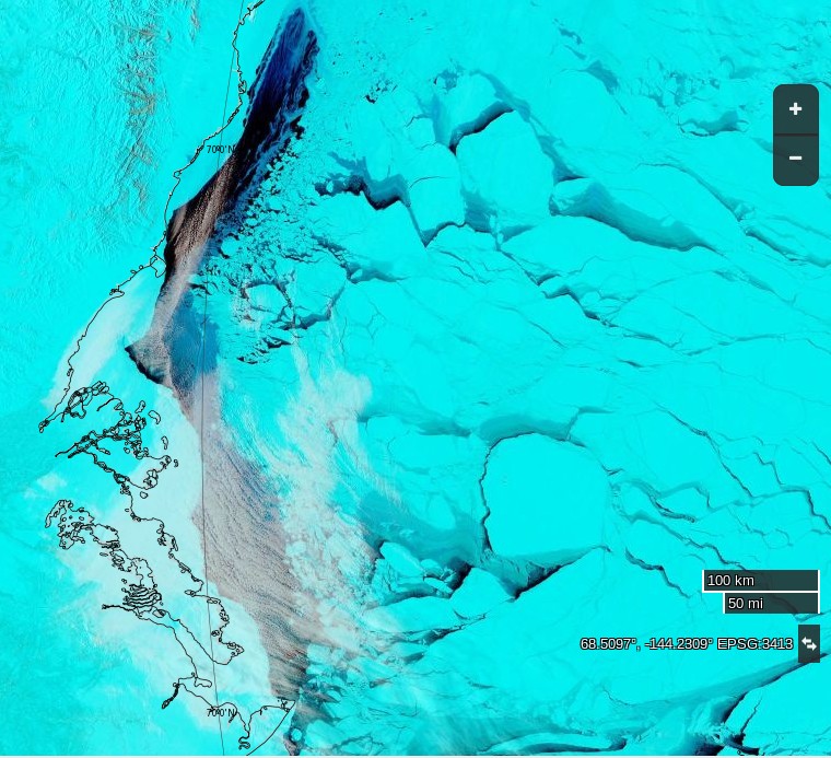
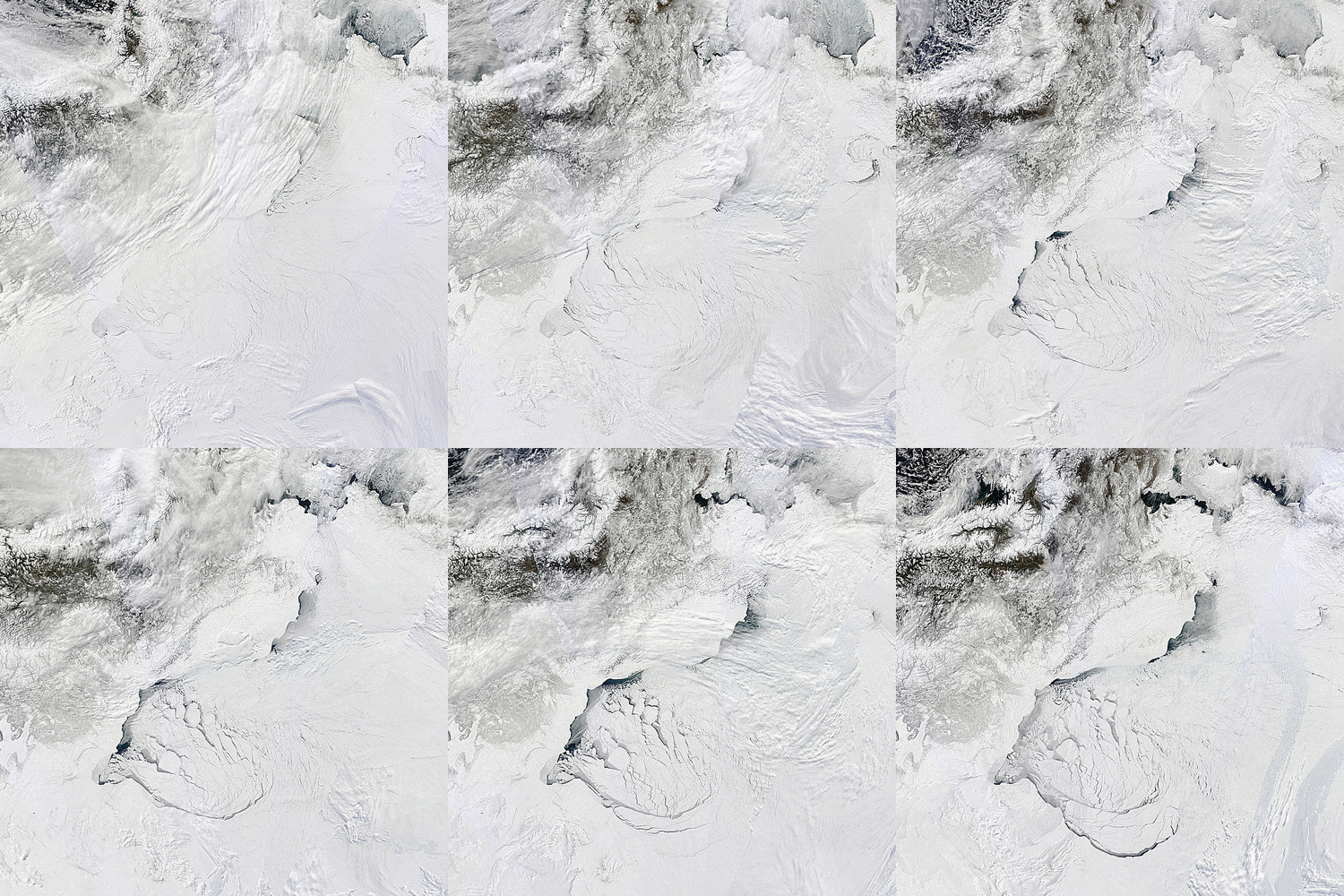
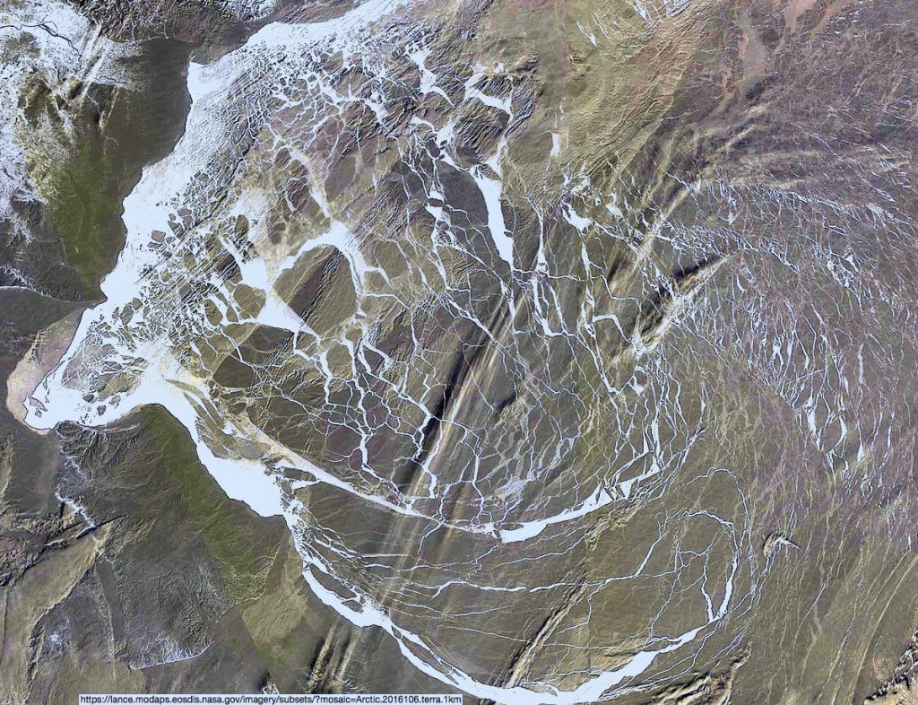
Such a high pressure system has been in place over the Arctic Ocean for a few days now, and the effect of the clockwise circulation on the sea ice in the Beaufort Sea is already evident in these recent satellite images:

NASA Worldview “true-color” image of the Beaufort Sea on April 9th 2016, derived from the MODIS sensor on the Terra satellite

NASA Worldview “false-color” image of the Beaufort Sea on April 12th 2016, derived from the MODIS sensor on the Terra satellite

as well as in this animation of sea ice movement since February:

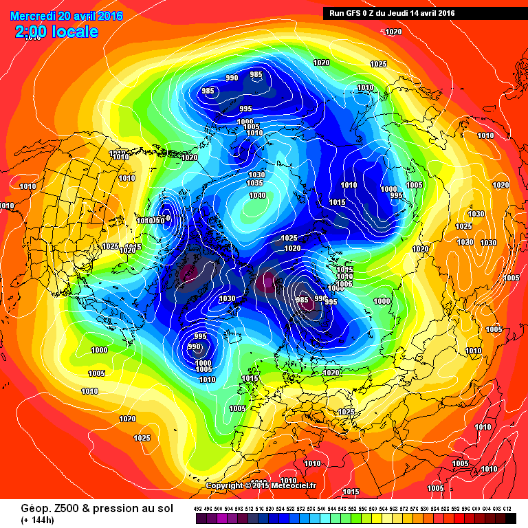
The high pressure is forecast to continue for several more days. Here’s the GFS forecast for April 20th, courtesy of MeteoCiel:

Northern Hemisphere surface pressure forecast for April 20th 2016

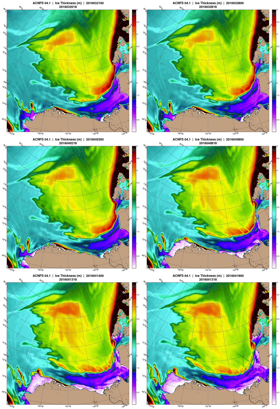
which shows a large system with a central pressure of 1040 hPa still sitting over the Northern Beaufort Sea. Next here’s an animation from the US Navy which forecasts ice thickness until April 19th:

April 13th 2016 ACNFS Beaufort Sea thickness forecast until April 19th

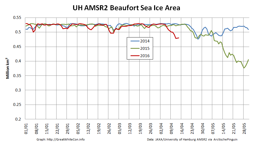
Note in particular the large area of open water forecast to be produced in the Chukchi sea off Barrow, Alaska by the end of the period. The continuing clockwise winds have already started reducing the area of sea ice in the Beaufort Sea at an unusually early date:

2016-04-13-Beaufort-AMSR2-Area_001

Amongst other things we’ll be keeping a close eye on the ice area in the Chukchi Sea over the next few days. The sun is already starting to bathe that area of our planet with its rays, and open ocean soaks up that heat much more readily than bright white ice.

[Edit – 16/04/2016]

Here’s an animation of the effect on sea ice of the Beaufort Gyre in overdrive from Neven at the Arctic Sea Ice Blog:

Neven-Gyre-20160414

Notice how towards the end of the animation another huge part of the ice pack, north of the Canadian Arctic Archipelago is pulled into the Gyre. This is mostly multi-year ice.

Here also is a MODIS image of the Beaufort Sea processed by A-Team at the Arctic Sea Ice Forum to highlight the areas of new ice:

ATeam-BeaufortDay106-2016

New Calving of the Zachariae Isstrom Glacier

The Zachariæ Isstrøm glacier in North East Greenland is in the news at the moment. Here’s a recent article from The Guardian for example, which states that:

A major glacier in Greenland that holds enough water to raise global sea levels by half a metre has begun to crumble into the North Atlantic Ocean, scientists say. The calving of the glacier into chunks of floating ice will set in train a rise in sea levels that will continue for decades to come, the US team warns.

“Even if we have some really cool years ahead, we think the glacier is now unstable,” said Jeremie Mouginot at the University of California, Irvine. “Now this has started, it will continue until it retreats to a ridge about 30km back which could stabilise it and perhaps slow that retreat down.”

Mouginot and his colleagues drew on 40 years of satellite data and aerial surveys to show that the enormous Zachariae Isstrom glacier began to recede three times faster from 2012, with its retreat speeding up by 125 metres per year every year until the most recent measurements in 2015.

The same records revealed that from 2002 to 2014 the area of the glacier’s floating shelf shrank by a massive 95%, according to a report in the journal Science. The glacier has now become detached from a stabilising sill and is losing ice at a rate of 4.5bn tonnes a year.

Eric Rignot, professor of Earth system science at the University of California, Irvine, said that the glacier was “being hit from above and below”, with rising air temperatures driving melting at the top of the glacier, and its underside being eroded away by ocean currents that are warmer now than in the past.

“The glacier is now breaking into bits and pieces and retreating into deeper ground,” he said. The rapid retreat is expected to continue for 20 to 30 more years, until the glacier reaches another natural ledge that slows it down.

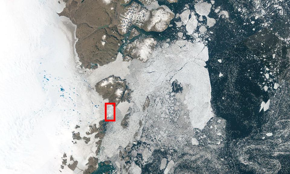
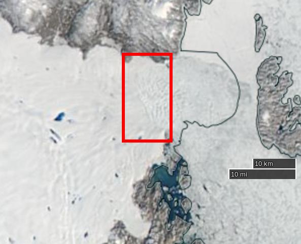
The Guardian article includes a picture of Zachariæ Isstrøm, along with much of the rest of North East Greenland. Here it is again, together with a helpful annotation revealing the location of the calving face of Zachariæ Isstrøm in amongst all the snow and ice:

zach-guardian

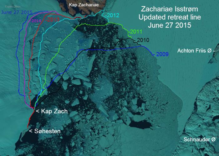
That’s still not really much help when it comes to visualising the “retreat speeding up by 125 metres per year”, so here’s a closer look at Zachariae Isstrom using an image prepared by Espen Olsen for the Arctic Sea Ice Forum, which is based on a Landsat 8 satellite image from September 2014:

Retreat of the calving face of the Zachariae Isstrøm glacier between 2009 and 2015

North East Greenland is in the dark at the moment, but if you want to take a closer look at recent changes to Zachariæ Isstrøm for yourself you can do so with the aid of NASA’s EOSDIS Worldview web site, which allows you to scroll through images from both the Aqua and Terra satellites. Here’s one from August 26th 2015:

NASA Worldview “true-color” image of the Zachariae Isstrøm glacier on August 26th 2015, derived from the MODIS sensor on the Aqua satellite

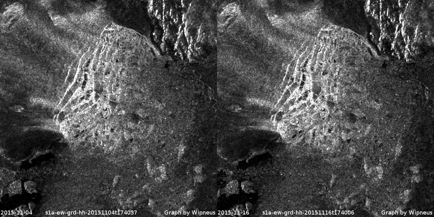
Our headline for today announces that yet another large chunk of ice has just detached itself from Zachariæ Isstrøm. You may wonder how we can be so sure of that when it’s dark in North East Greenland? That’s because yet another satellite can “see” in the dark, using synthetic aperture radar. Here’s an animation prepared earlier today by “Wipneus” using data from the European Space Agency’s Sentinel 1A satellite, once again for the Arctic Sea Ice Forum:

Animated comparison of Sentinel 1A visualisations of the Zachariae Isstrøm calving face on 4th and 16th November 2015

Can you spot “The new iceberg [that] seems to lie on its side”?

The conclusion to all this frantic activity, according to Mouginot, Rignot et al. at least, is that:

The Zachariæ Isstrøm / Nioghalvfjerdsfjorden sector is one of three major marine-based basins in Greenland along with the Jakobshavn Isbræ and Petermann–Humboldt glaciers, each holding a 0.6-m sea-level equivalent. Jakobshavn Isbræ started a rapid retreat (18 km in 2001-2015) following the collapse of its ice shelf and has undergone massive calving events since 2010. The central channel of the Petermann ice shelf lost 250 m of ice in 2002-2010, and the ice front retreated 33 km in 2010-2012. The Nioghalvfjerdsfjorden ice shelf will become vulnerable to break up in the near future if thinning continues. These observations combined suggest that all three major marine-based basins are undergoing significant changes at present. Jakobshavn Isbræ and Zachariæ Isstrøm have already transitioned to tidewater glacier regime, with increased calf-ice production and ice melting by the ocean. The retreat of these marine-based sectors is likely to increase sea-level rise from Greenland for decades to come.

The New Normal In The Arctic

The latest headline on the so called “Real Science” blog reads as follows:

The New Normal In The Arctic – Cold Summers

According to “Steven Goddard”:

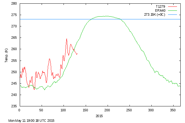
For the third year in a row, near-polar temperatures have dropped below normal in May.

meant_20150511

Both of the last two years, temperatures stayed below normal for the entire melt season.

The below normal summer temperatures are keeping the ice from melting, and have led to a large expansion in the amount of thick multi-year ice.

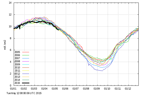
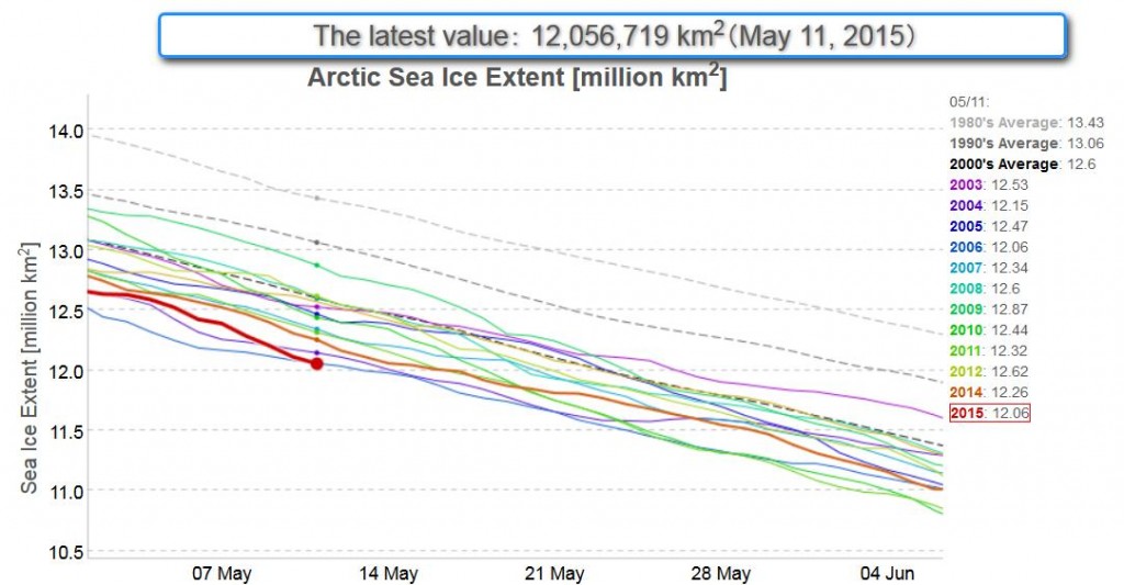
However the Arctic is unfortunately failing to cooperate with that narrative. Today we are unhappy to report that Tony Heller‘s favourite Arctic sea ice metric, the Danish Meteorological Institute 30% threshold extent, is at the lowest level ever for the date since their records began:

DMI-30_20150512

What is more, so is the JAXA 15% extent metric:

2015-05-12_JAXA

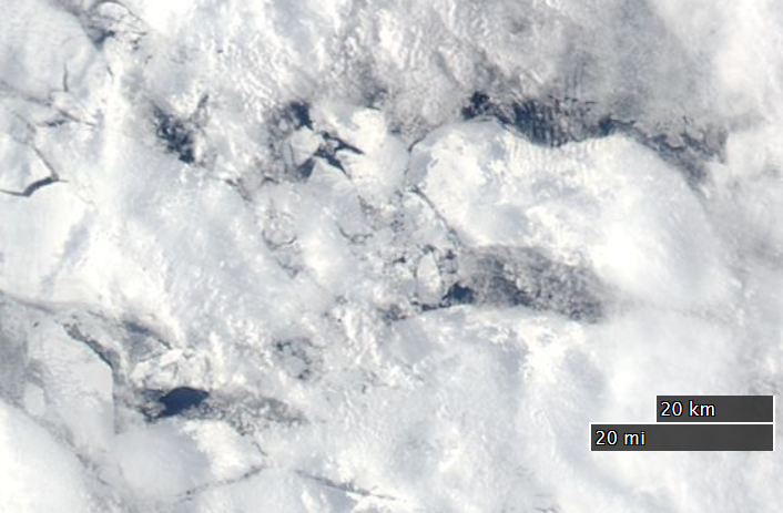
As if that wasn’t enough to be going on with, some big holes have already appeared in the middle of the supposedly multi-meter thick, multi-year sea ice in the Beaufort Sea, well away from the open water already warming up off the Mackenzie Delta:

NASA Worldview “true-color” image of The Beaufort Sea on May 11th, derived from bands 1, 4 and 3 of the MODIS sensor on the Aqua satellite

The Arctic Sea Ice “Recovery” Vanishes Even More

Whilst a variety of climate change “skeptics” have been pointing out recently that the April 2014 edition of the National Snow and Ice Data Center’s Arctic Sea Ice News mentioned that:

A large area of the multiyear ice has drifted to the southern Beaufort Sea and East Siberian Sea

which led said skeptics to claim things like:

There is a lot of thick ice in the western Arctic, which will be difficult to melt this summer.

they glossed over the bit where the NSIDC added:

Where warm conditions are likely to exist later in the year.

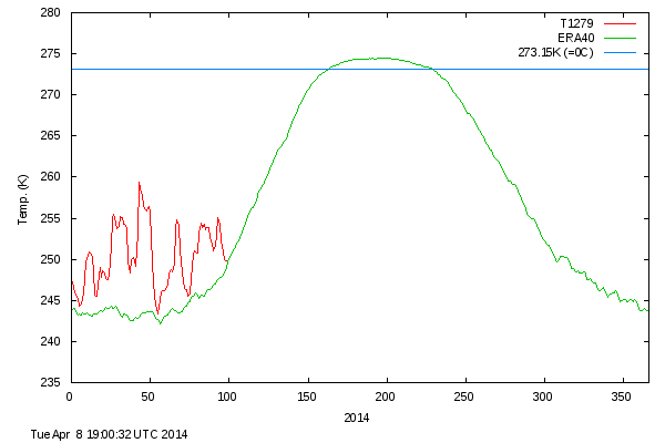
In fact conditions have been very warm (relatively speaking!) in the Arctic for all of 2014 so far. The DMI daily mean temperature of the Arctic area north of the 80th northern parallel has never dropped below the long term average all winter:

DMI mean temperature north of the 80th northern parallel, on April 8th 2014

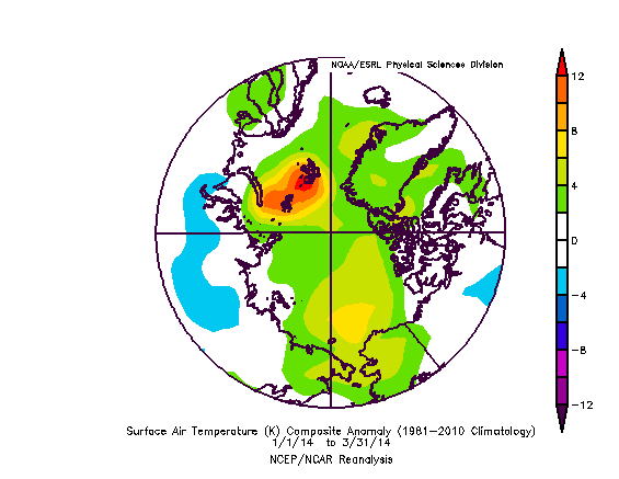
and the surface air temperature anomaly chart for the Arctic for the first three months of 2014 looks like this:

Surface air temperature anomaly plot for January to March 2014
Arctic surface air temperature anomaly plot for January to March 2014

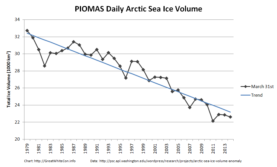
Those anomalously warm temperatures may well have something to do with the fact that the latest PIOMAS Arctic sea ice volume estimates which have just been released reveal this:

PIOMAS arctic sea ice volume on March 31st from 1979-2014

As you can see, according to the PIOMAS model at least, Arctic sea ice volume has now reached the second lowest level for the date since the satellite record began.

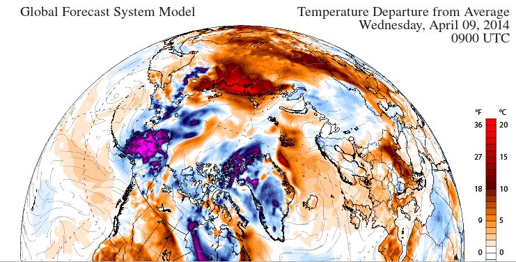
Whilst the skeptics have been complaining about the amount of ice on the Great Lakes of North America they seem to have somehow failed to notice the anomalously low coverage of snow over Siberia. Here’s the surface air temperature anomaly forecast for the northern hemisphere tomorrow:

GFS 2m temperature anomaly forecast for 09:00 UTC on April 9th 2014

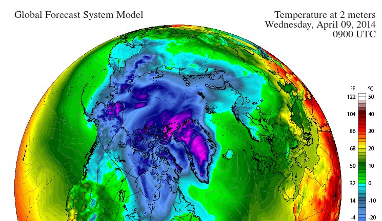
Do you see the bright red patch over the coast of the Laptev Sea, indicating temperatures 20 degrees Celsius above normal? Now take a look at a similar chart, but of the surface air temperatures themselves:

GFS 2m temperature forecast for 09:00 UTC on April 9th 2014

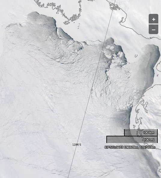
That reveals that the temperatures over the edge of the Laptev Sea are forecast to be above the freezing point of fresh water tomorrow. Just in case you’re wondering what the shores of the Laptev Sea look like at the moment, here’s a picture we recorded earlier today, courtesy of NASA Worldview and the MODIS sensor on the Aqua satellite:

The Laptev Sea as seen by the Aqua satellite on April 8th 2014

What do you suppose the same area will look like in a day or two’s time, or in a month or two’s time for that matter?


How to Upset a Global Warming Sceptic

We are proud to bring you this blast from Steven Goddard’s past, reprinted with permission from econnexus.org.uk:

In the first of an occasional series under the “Shock News” banner we reveal how to upset a global warming sceptic in three easy stages.

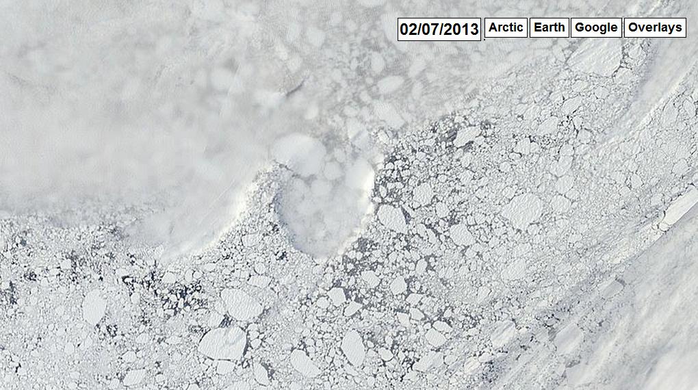
  1. Smell something fishy about a headline that states “New Ice At The North Pole” on July 2nd 2013 and examine “the evidence” from arctic.io presented to substantiate this assertion:
Satellite image of sea ice near the North Pole on July 2nd 2013, courtesy of arctic.io
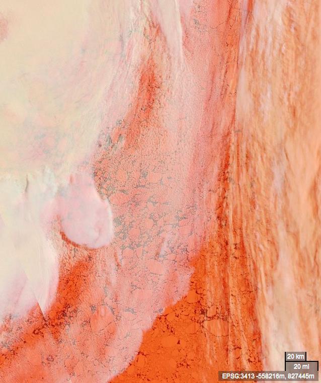
  1. Post a link to an alternative view of the same scene from NASA Worldview:
Satellite image of sea ice near the North Pole on July 2nd 2013, courtesy of NASA EOSDIS Worldview
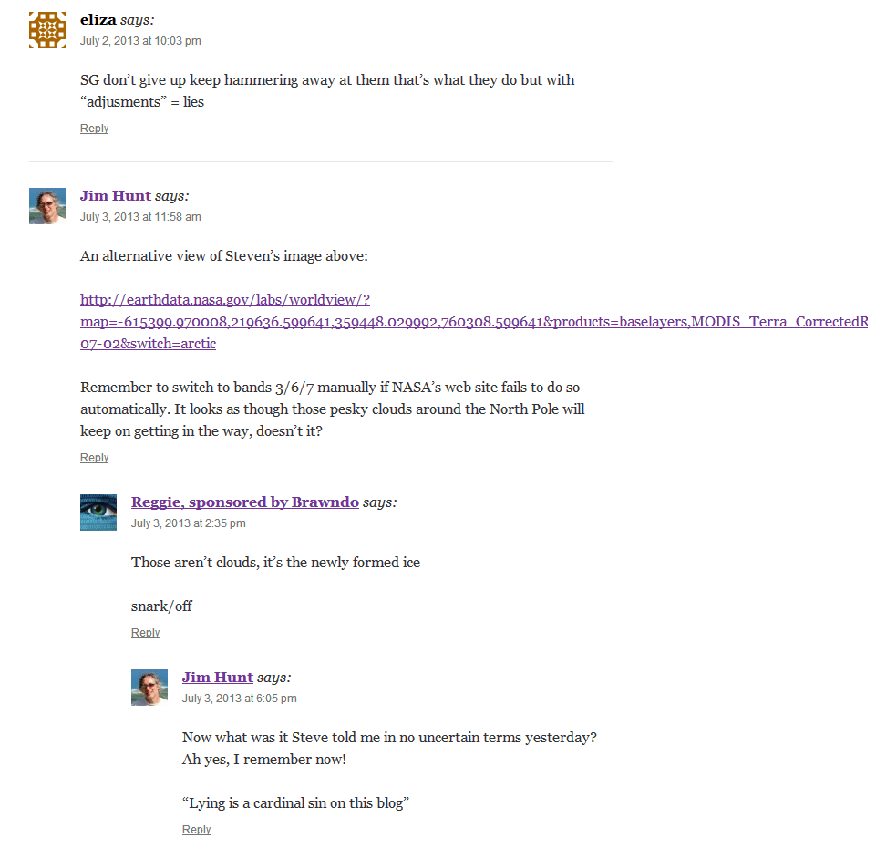
  1. Indulge in a little light hearted banter
A little light hearted banter on July 3rd 2013
  1. QED!
Whoops!
Whoops!
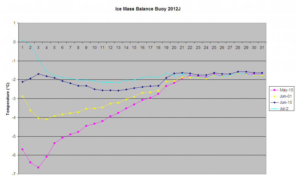
  1. Hence no opportunity to present any “real scientific” evidence about what’s really happening to the Arctic sea ice near the North Pole:
Thermistor temperature profiles for IMB 2012J