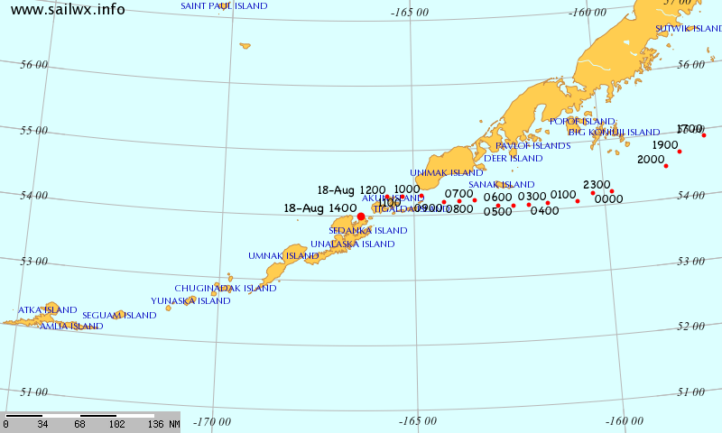
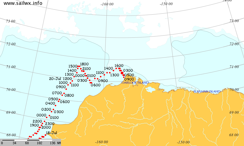
After a voyage through the Northwest Passage untroubled by sea ice in 2016, the cruise liner Crystal Serenity has set sail for the Bering Strait and beyond once again. The SailWX tracking map shows her passing the Aleutian Islands:
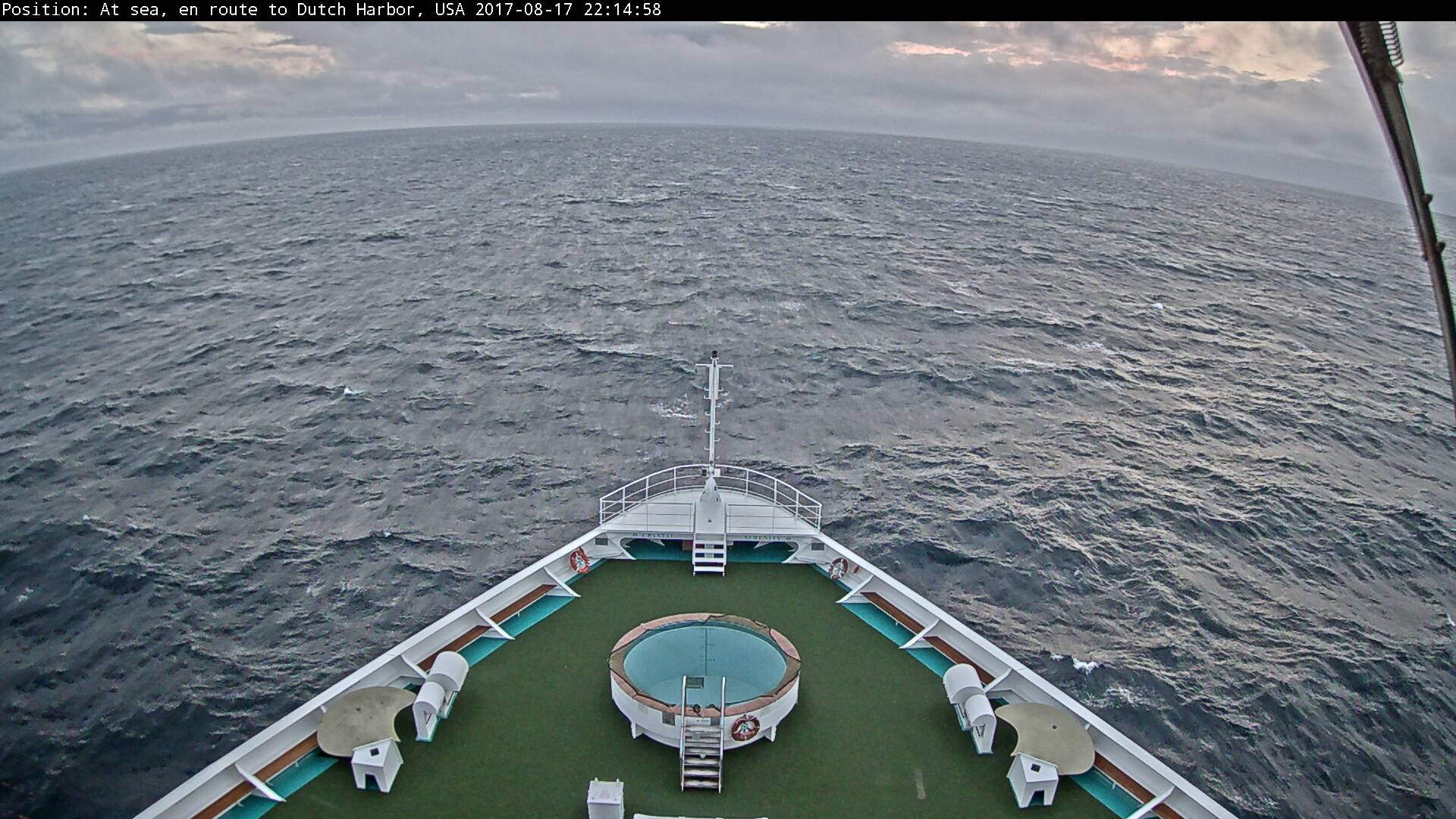
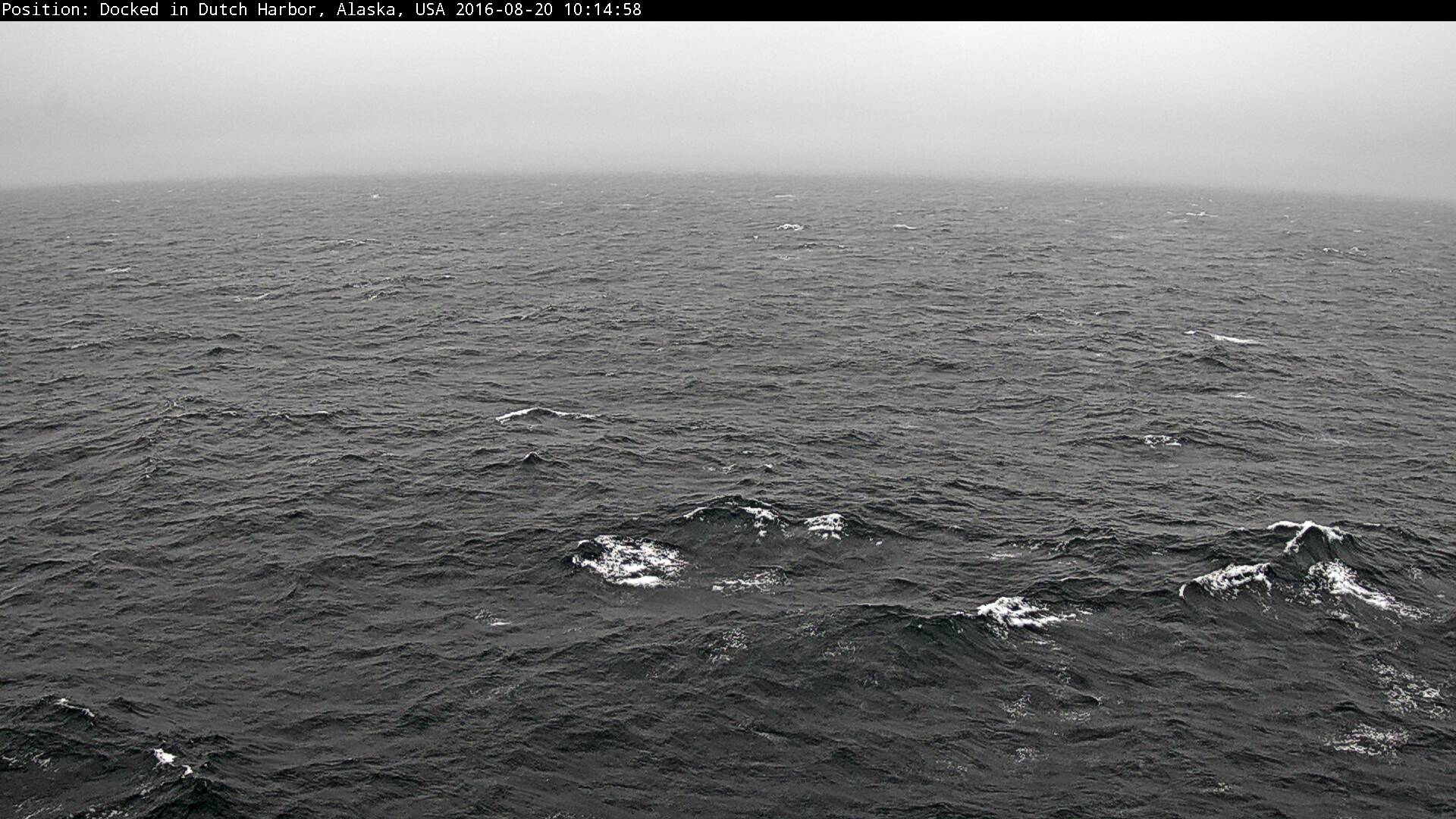
and although there is of course no sea ice to be seen yet her forward facing webcam reveals Dutch Harbor as her next port of call:
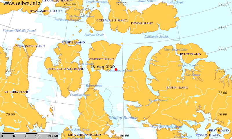
Much like last year, it looks as though the British icebreaker Ernest Shackleton is on its way to assist her:
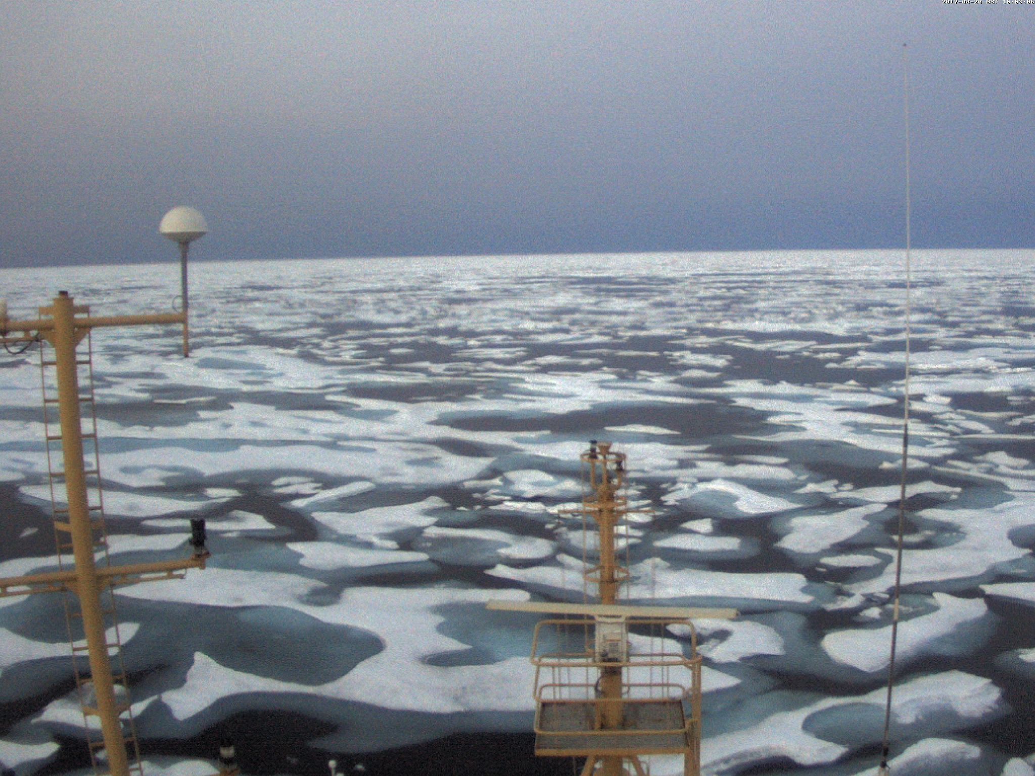
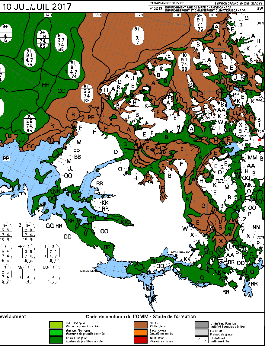
Having an icebreaker in attendance might well prove to be essential this year, since, according to the Canadian Ice Service, Larsen Sound is currently still full of sea ice:
[Edit – August 21th]
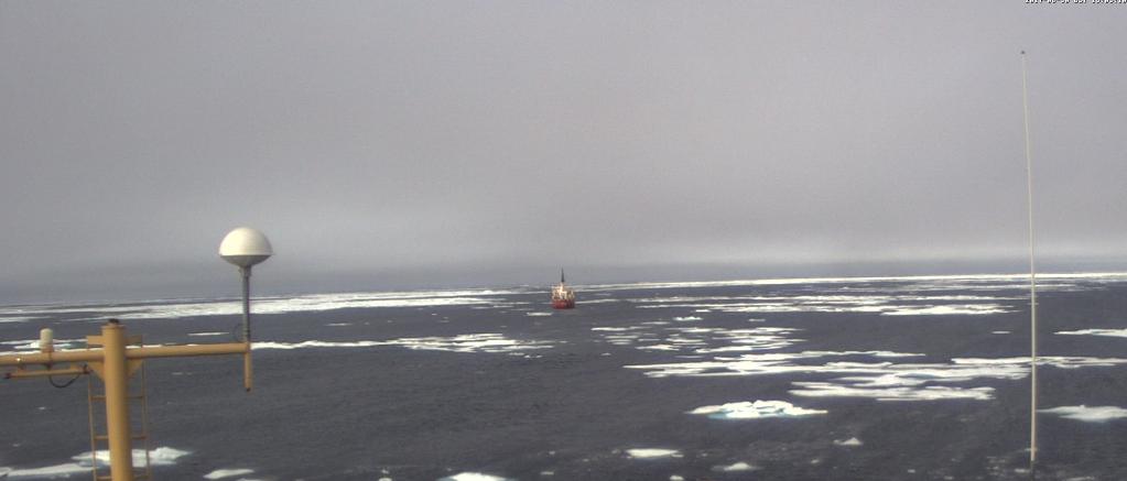
Heading westwards to meet Crystal Serenity, this is what met the RRS Ernest Shackleton in Franklin Strait:
Meanwhile Crystal Serenity is about to pass through the (ice free!) Bering Strait:
[Edit – August 29th]
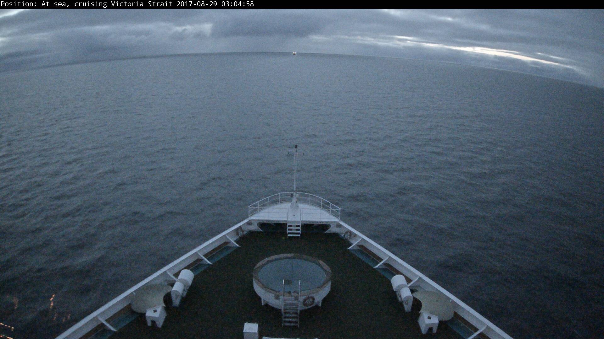
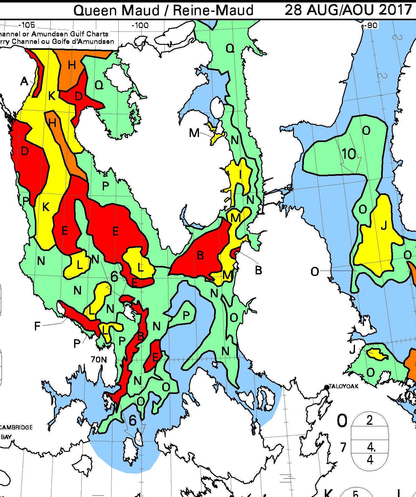
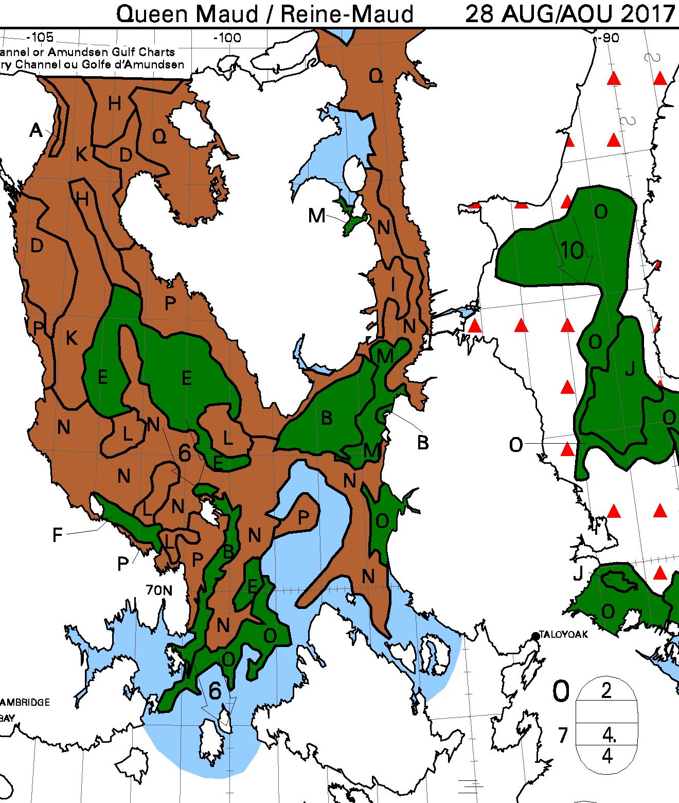
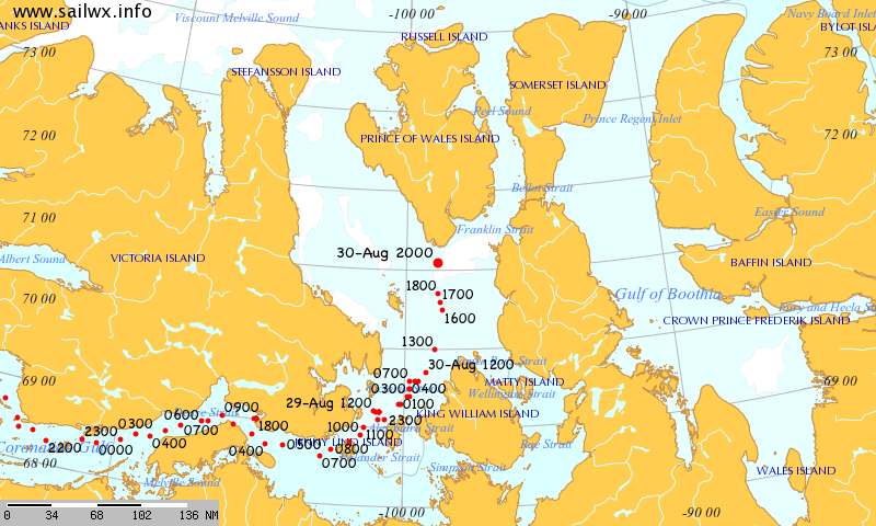
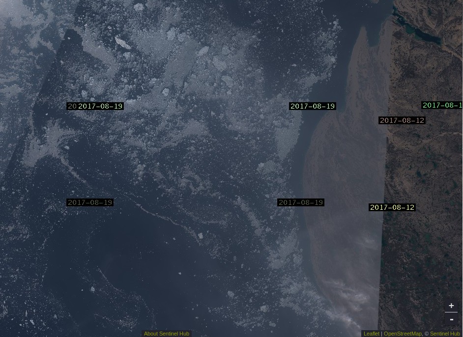
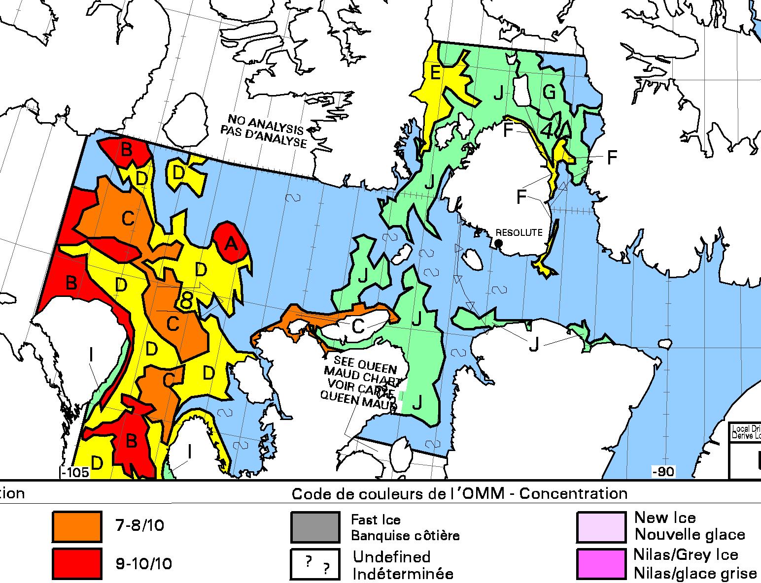
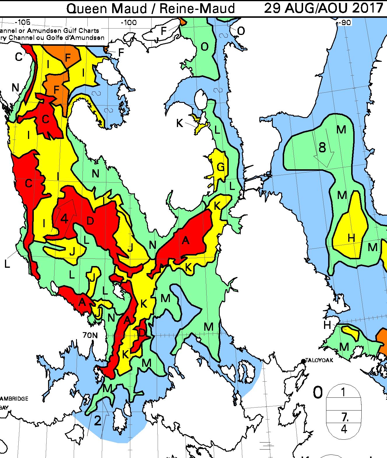
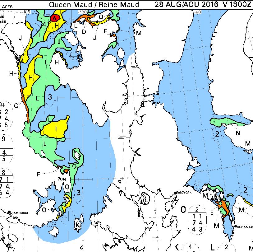
Crystal Serenity is now heading through Queen Maud Gulf:
but there is as yet no sign of any sea ice:
However some should come into view later today. Here are the latest Canadian Ice Service sea ice charts of the area:
[Edit – August 29th 11:30]
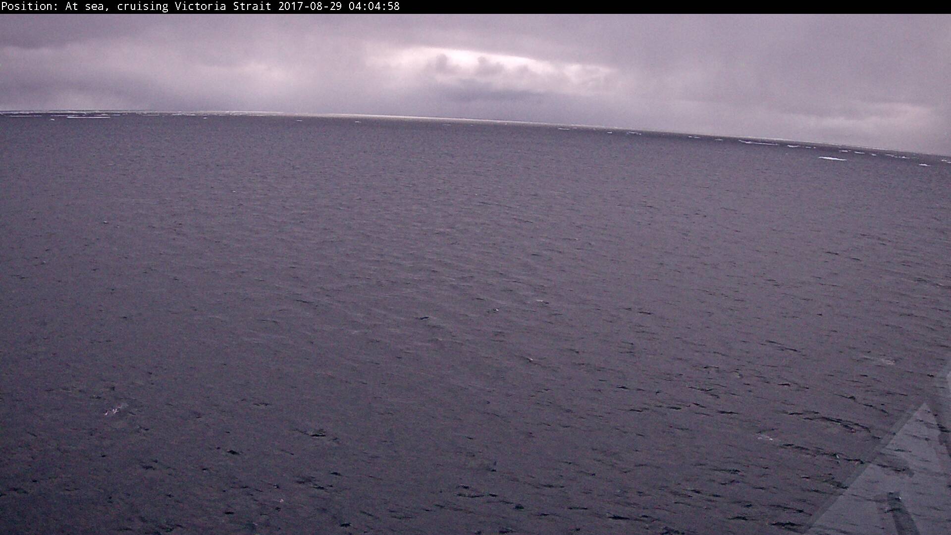
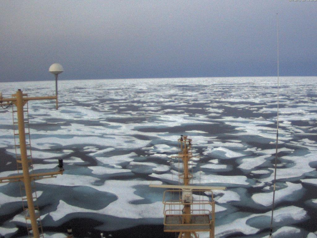
Crystal Serenity has spotted some sea ice!
[Edit – August 29th 17:30]
Crystal Serenity and Ernest Shackleton are well in amongst the ice now, as are the former’s passengers:
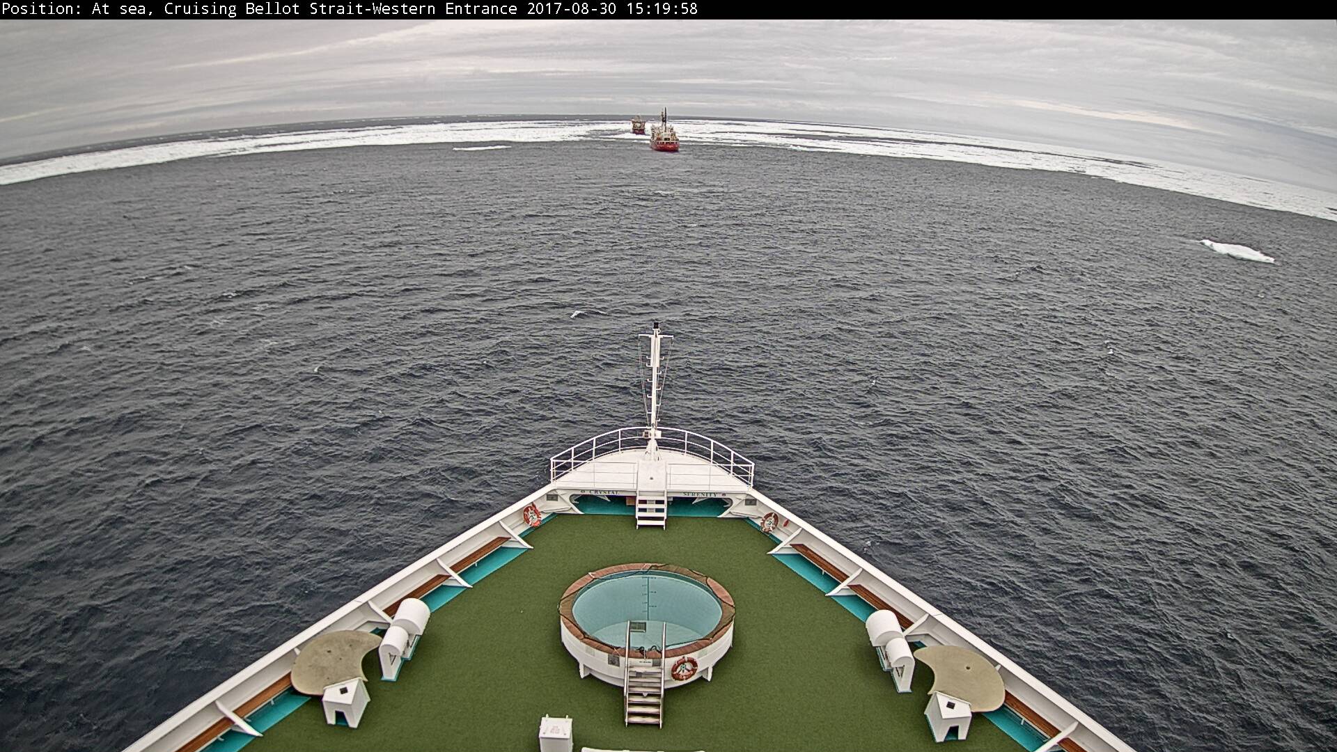
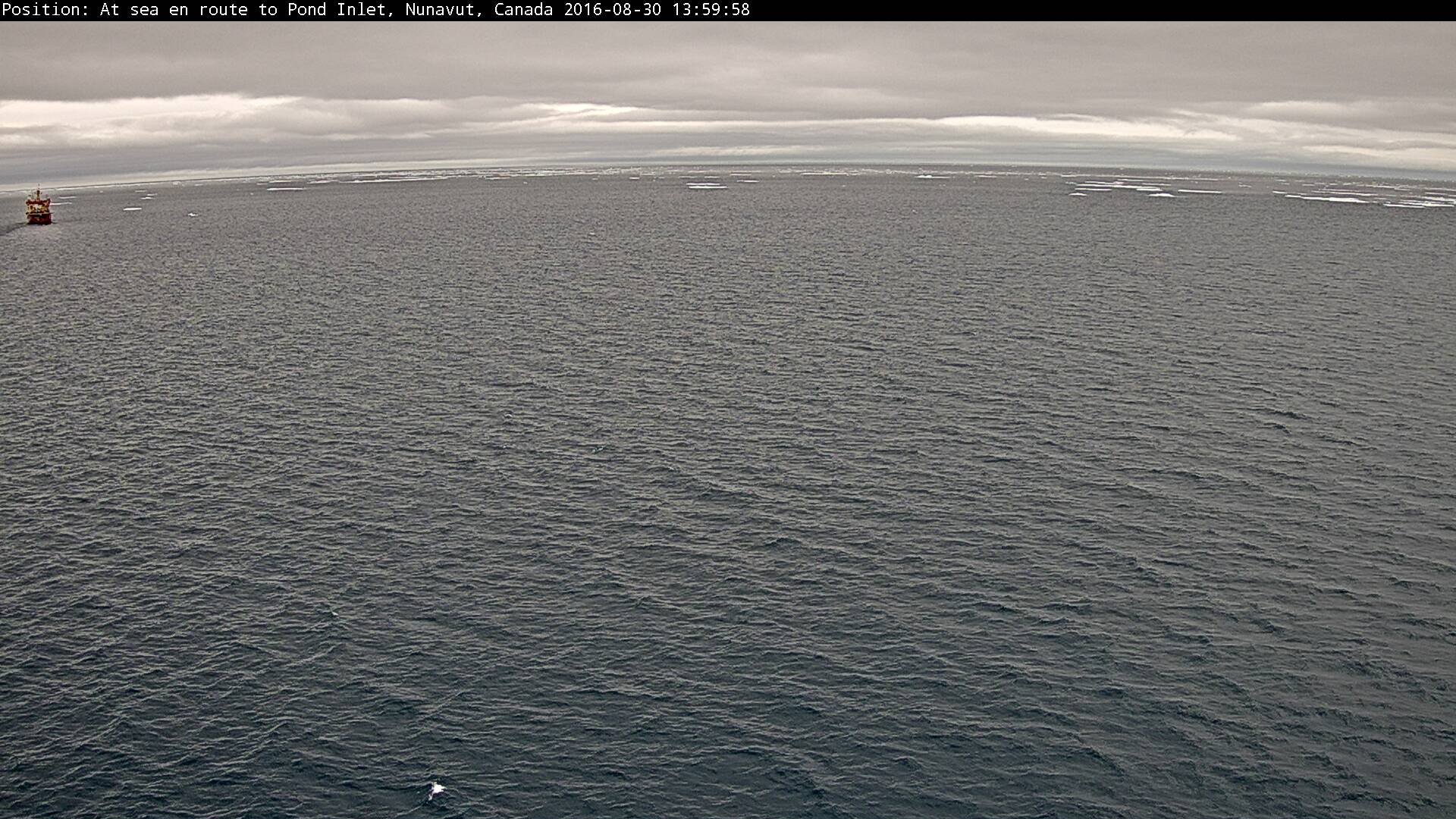
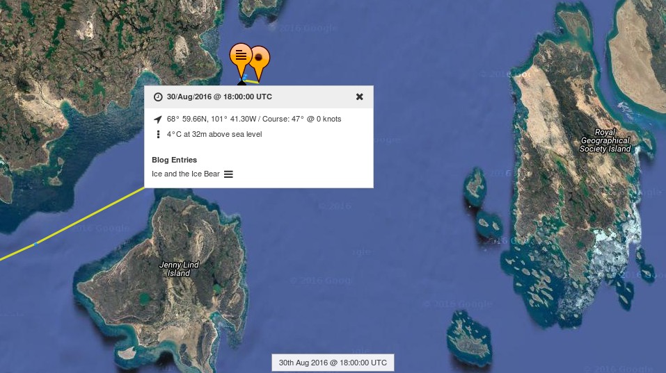
[Edit – August 30th]
Crystal Serenity is now entering the Franklin Strait in the wake of TWO icebreakers:
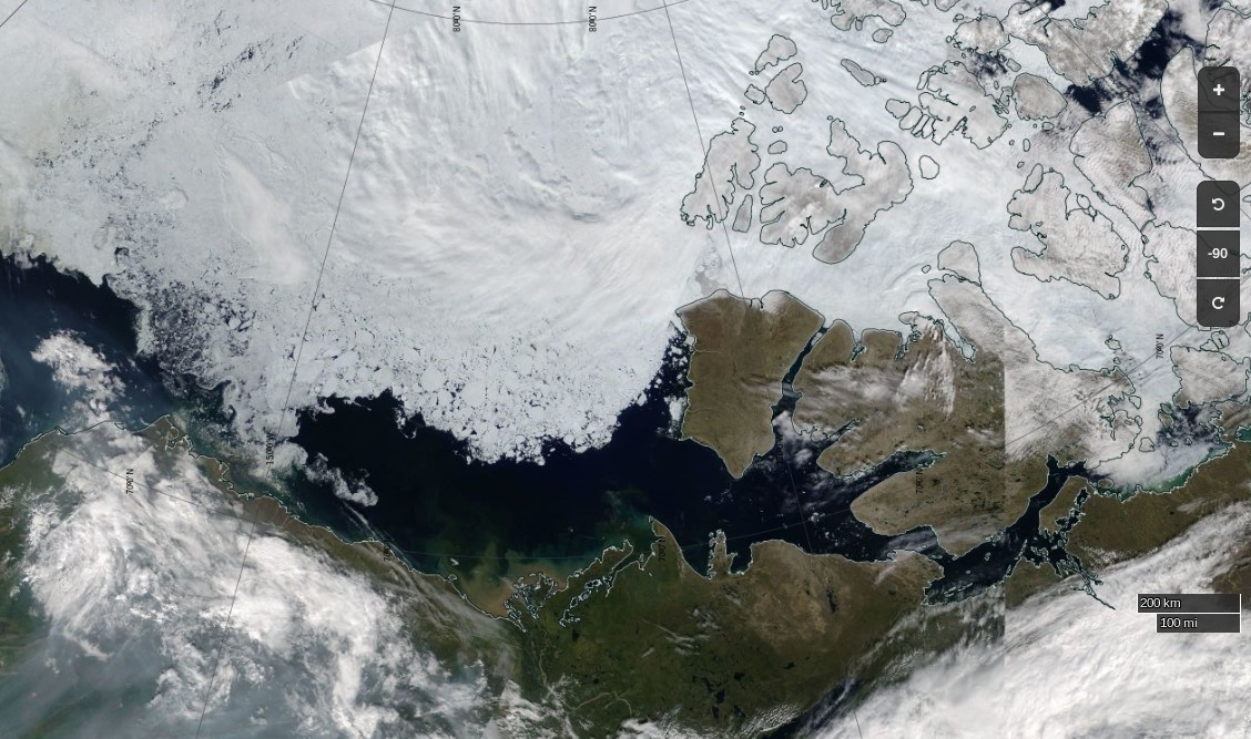
The time has come to start speculating about if, and when, the Northwest Passage will become navigable for the host of small vessels eager to traverse it this summer. The west and east entrances are clearing early this year. Lancaster Sound and Prince Regent inlet already reveal only a few area of white amongst the deep blue open water:
NASA Worldview “true-color” image of Lancaster Sound and Prince Regent Inlet on July 8th 2017, derived from the MODIS sensor on the Aqua satellite
To the west the route is already opening up all the way from the Chukchi Sea to Cambridge Bay:
NASA Worldview “true-color” image of the Beaufort Sea on July 12th 2017, derived from the MODIS sensor on the Terra satellite
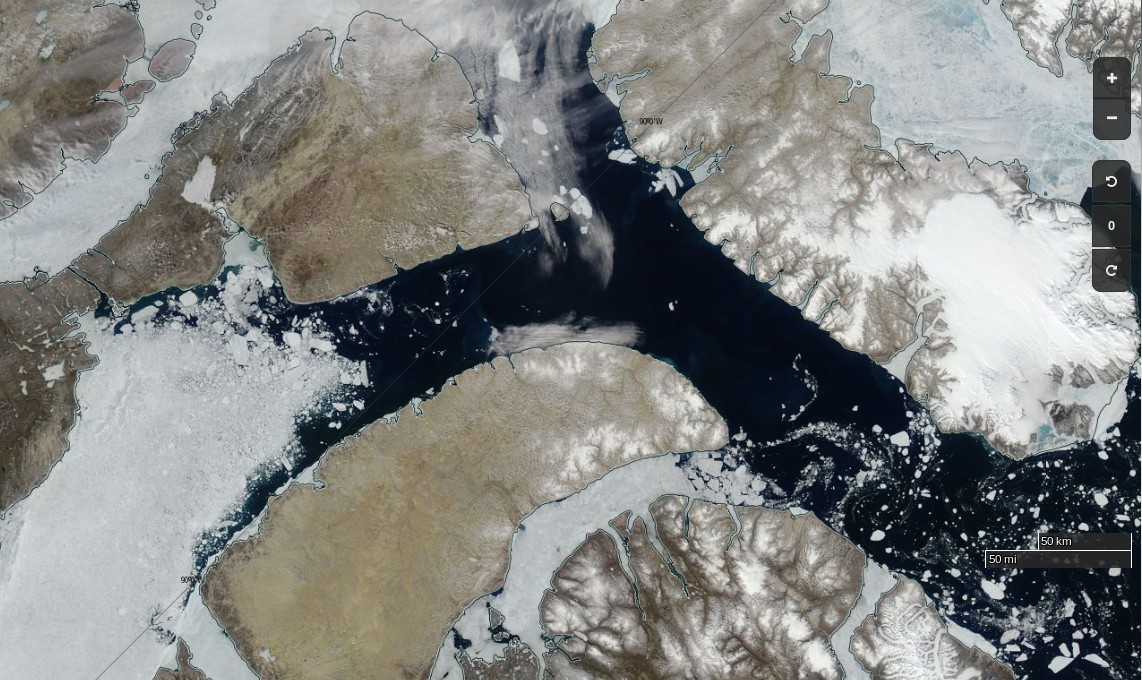
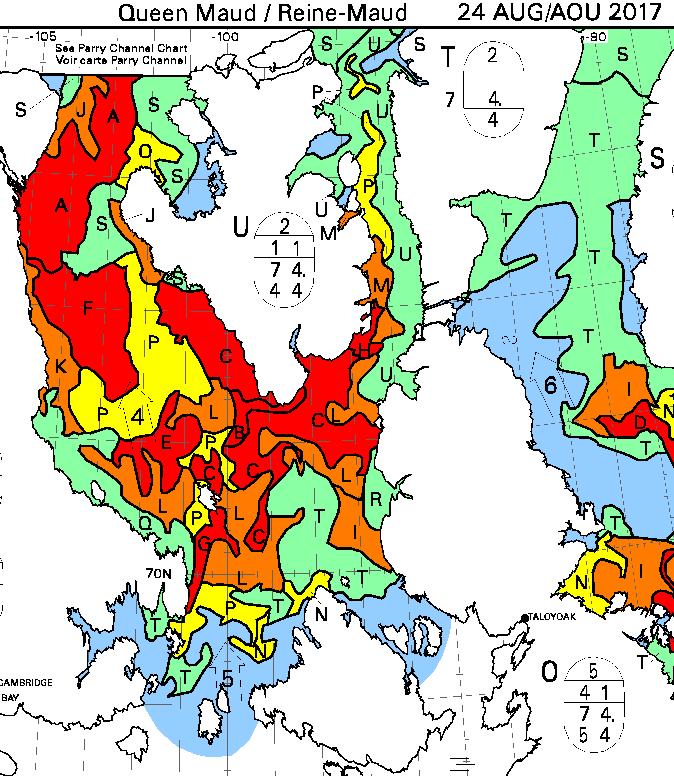
The problems on the southern route seem likely to arise in the central section this year, where far more old ice is present this year than in 2016:
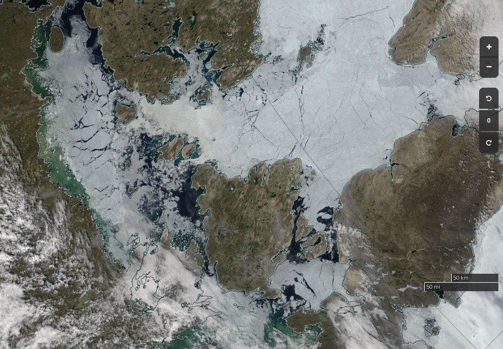
The remaining sea ice in Queen Maud Gulf doesn’t look like it will last long, but the ice in Victoria Strait and Larsen Sound is made of much sterner stuff:
NASA Worldview “true-color” image of Victoria Strait and Larsen Sound on July 10th 2017, derived from the MODIS sensor on the Terra satellite
The cruise liner Crystal Serenity is anticipating navigating those waters once again this year, on August 29th. However much smaller craft are already heading for the Northwest Passage. Celebrate and Alkahest are already sailing north along the west coast of Greenland. Meanwhile Yvan Bourgnon is due to depart Nome, Alaska tomorrow, sailing his catamaran single handed in the opposite direction.
The crew of the Coast Guard Cutter Maple, a 225-foot seagoing buoy tender home ported in Sitka, Alaska, departed [July 12th] on a historic voyage through the Northwest Passage.
This summer marks the 60th anniversary of the three Coast Guard cutters and one Canadian ship that convoyed through the Northwest Passage. The crews of the U.S. Coast Guard Cutters Storis, SPAR and Bramble, along with the crew of the Canadian ice breaker HMCS Labrador, charted, recorded water depths and installed aids to navigation for future shipping lanes from May to September of 1957. All four crews became the first deep-draft ships to sail through the Northwest Passage, which are several passageways through the complex archipelago of the Canadian Arctic.
The crew of the cutter Maple will make a brief logistics stop in Nome, Alaska, to embark an ice navigator on its way to support marine science and scientific research near the Arctic Circle. The cutter will serve as a ship of opportunity to conduct scientific research in support of the Scripps Institution of Oceanography.
The Maple crew will deploy three sonographic buoys that are used to record acoustic sounds of marine mammals. A principal investigator with the University of San Diego embarked aboard the cutter will analyze the data retrieved from the buoys.
The Canadian Coast Guard Ship Sir Wilfrid Laurier will rendezvous with the Maple later this month to provide icebreaking services as the Maple makes it way toward Victoria Strait, Canada. The Maple has a reinforced hull that provides it with limited ice breaking capabilities similar to Coast Guard 225-foot cutters operating on the Great Lakes.
There doesn’t seem to be any up to date tracking information for the Maple, but CCGS Sir Wilfrid Laurier has recently arrived off Utqiaġvik (Barrow as was):
[Edit – August 18th]
Another article by Chris Mooney in the Washington Post includes this image of the eastern entrance to Bellot Strait on August 11th:
According to Chris:
After we’d passed through safely, Claude Lafrance, the ship’s commanding officer, took some time to explain how the strait worked with the help of a navigational chart. In the process, he lent credence to some of the observations made by Larsen over 70 years ago, while also explaining how modern knowledge has made navigating it safe with a proper tidal understanding.
The essence is that depending on when you are in Bellot Strait, the waters can be flowing either westward or eastward at and around high or low tide, respectively. So timing your crossing makes a great deal of difference.
The danger is that if you’re coming from the west (as we were) with the current to your back, you can be moving too fast, and have difficulty steering your vessel as you approach rocks at the end of the strait.
“We always want to go through where it’s more difficult, with the current against you, because it’s a lot easier to control the movement of your ship,” Lafrance said.
Therefore, the two-hour wait was quite intentional: The CCGS Amundsen stayed put until the tide began to shift and the waters to flow back westward, in effect neutralizing the current. Then the ship steamed out easily. “We just passed at the ideal time to go through,” Lafrance said.
Here’s Sentinel 2A’s view of what he should expect to see in Larsen Sound after emerging at the other end:
[Edit – August 21st]
From the RRS Ernest Shackleton in Franklin Strait or thereabouts:
[Edit – August 22nd]
From the C3 expedition, also in the Franklin Strait area by the look of things:
Yesterday, we broke through ice that was two metres thick. Thank you to the Canadian Ice Service for ensuring our safe passage! #CanadaC3pic.twitter.com/2nCgalwPOo
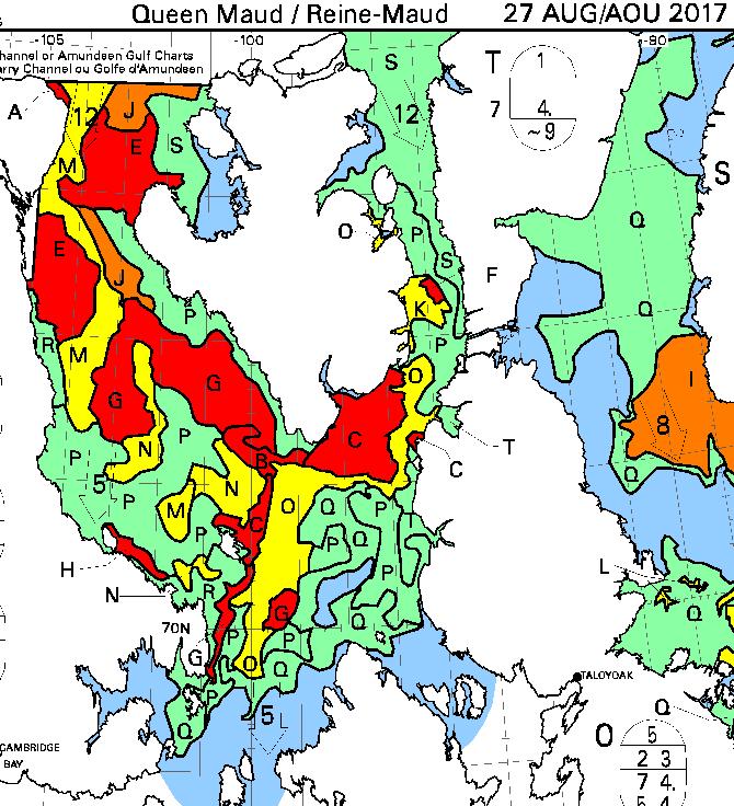
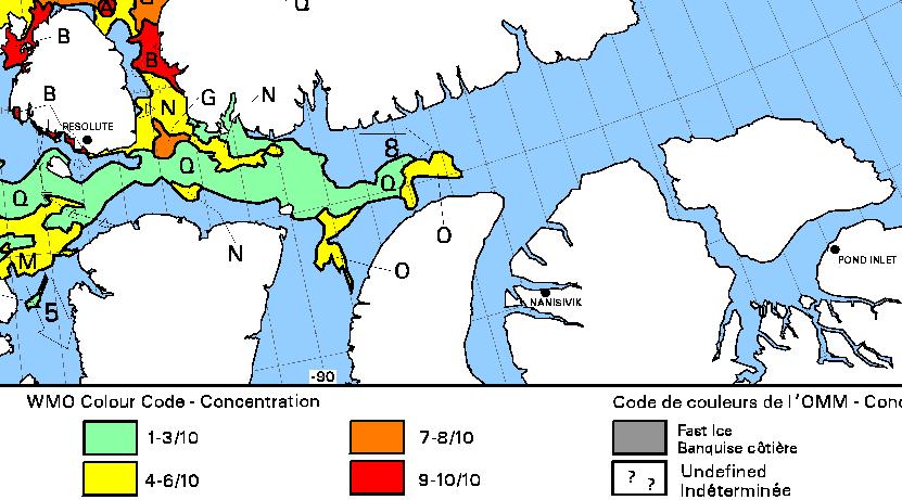
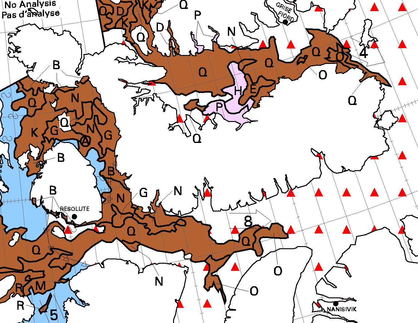
The latest CIS ice chart reveals a circuitous route via McClintock Channel that is ALMOST <= 6/10 concentration. Meanwhile Larsen Sound is still refusing to open up for the imminent arrival of the Crystal Serenity:
[Edit – August 27th]
At long last the CIS concentration map reveals a <= 6/10 concentration path along the entire southern route via Bellot Strait:
[Edit – August 29th]
It is now possible to squeeze through Roald Amundsen’s route through the Northwest Passage without encountering over 6/10 concentration sea ice:
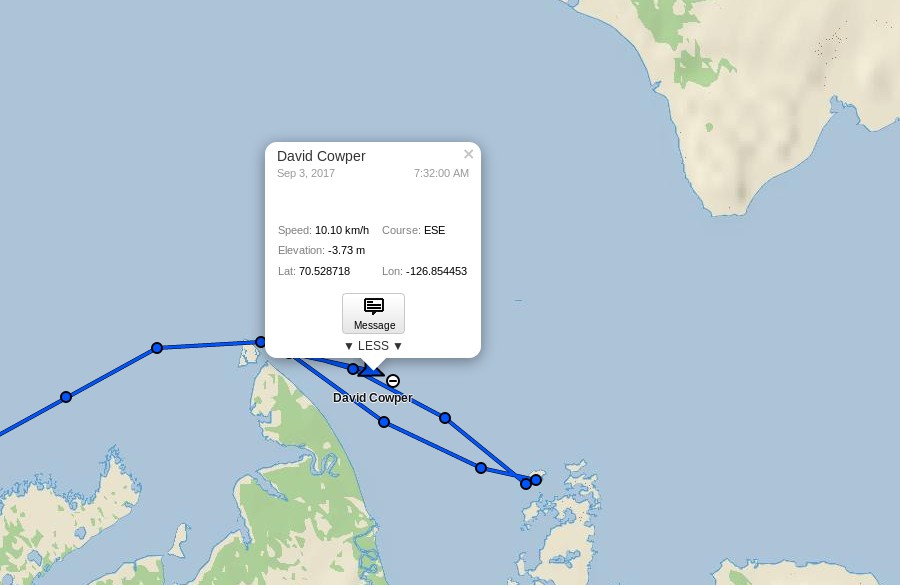
David Scott Cowper sought shelter for Polar Bound in the welcoming arms of Booth Island for a couple of days. Now they’re off again and have taken another close look at Cape Bathurst, but which route will they take now?
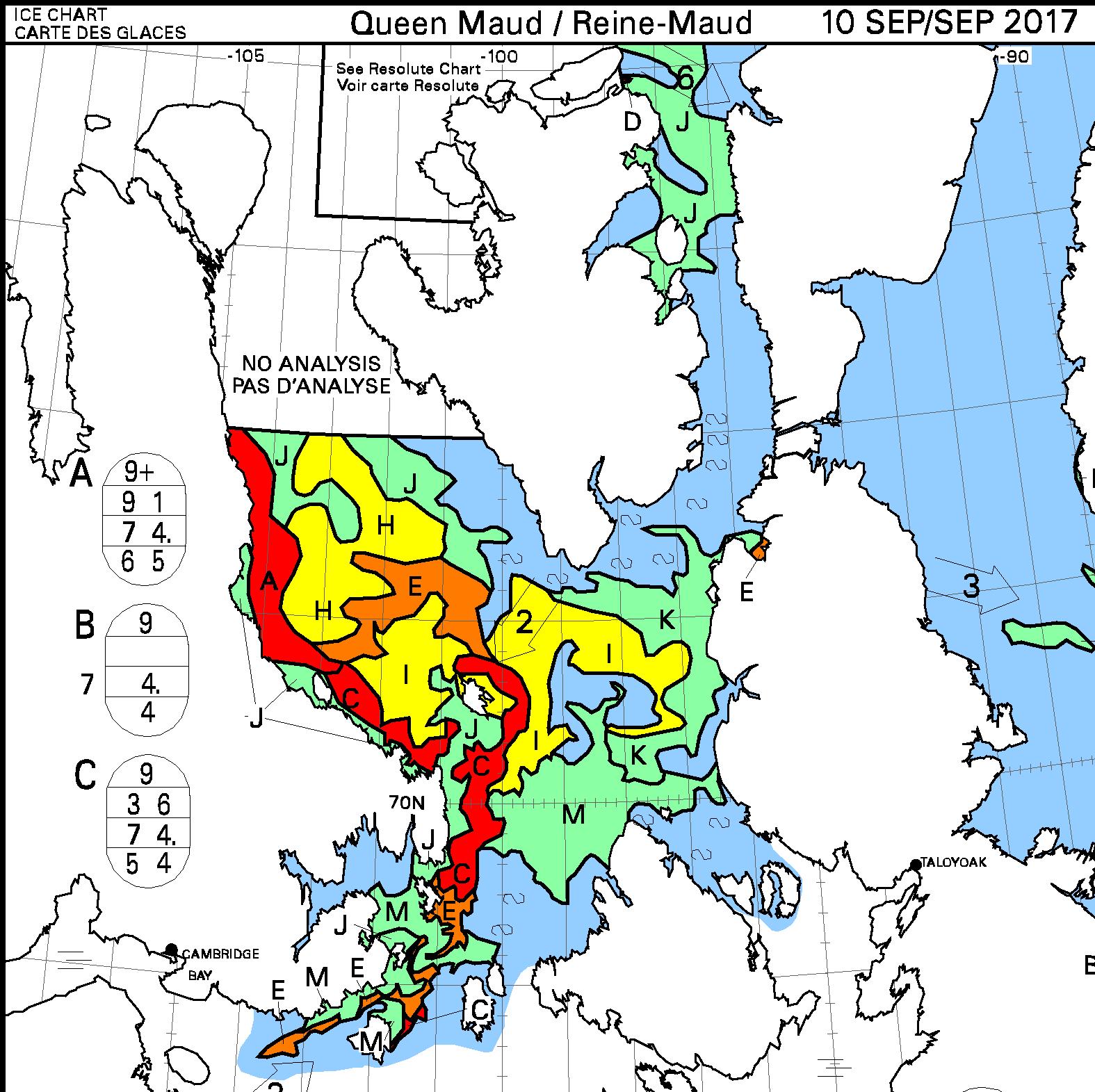
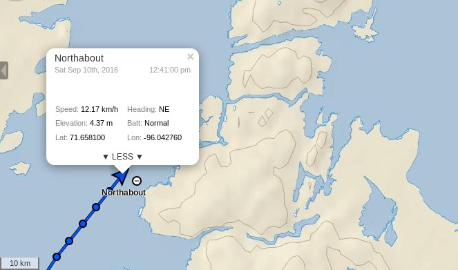
[Edit – September 10th]
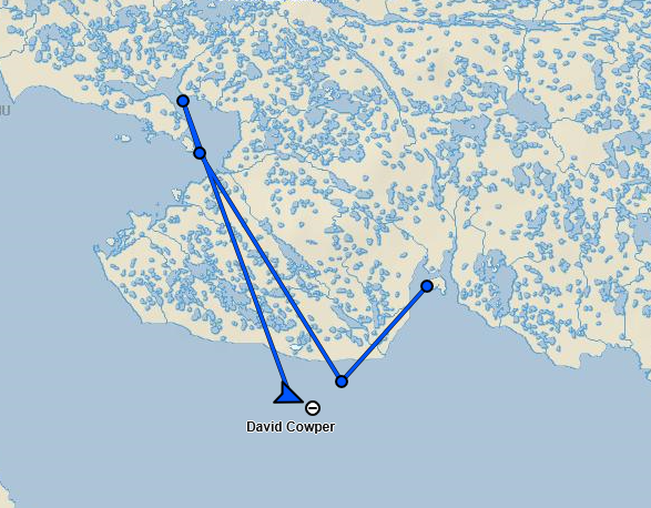
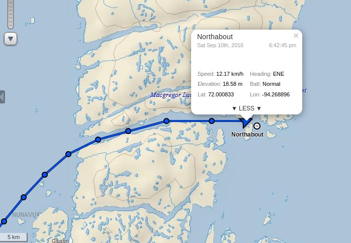
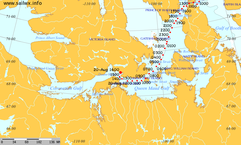
David Scott Cowper has left Cambridge Bay in Polar Bound and is heading east:
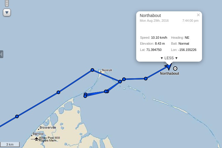
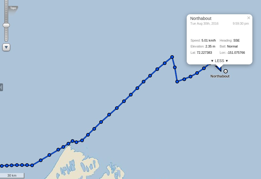
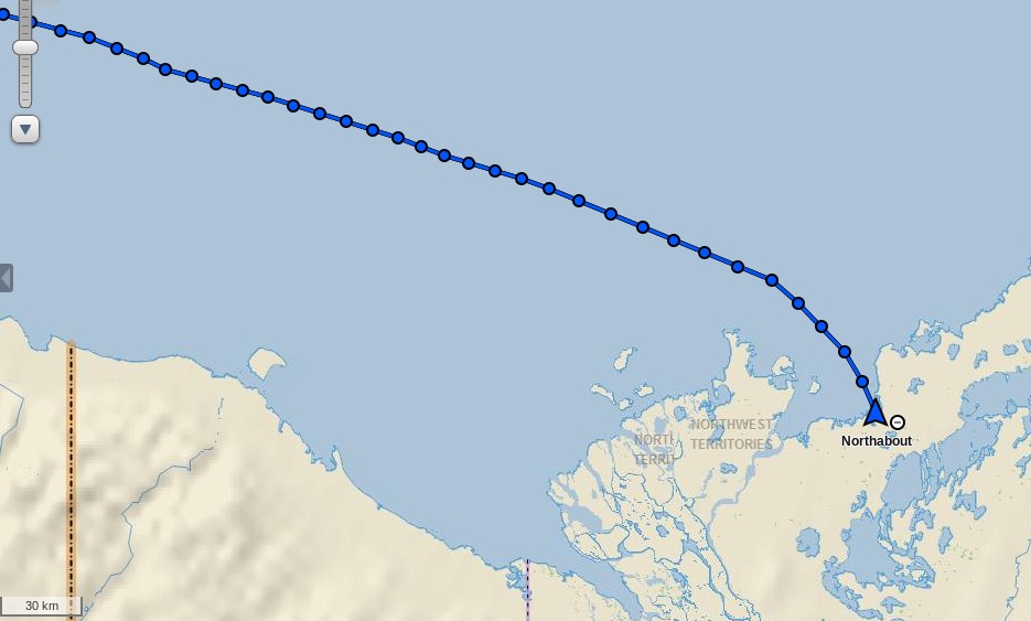
After the briefest of stops in Elson Lagoon behind Point Barrow Northabout is on the move once again:
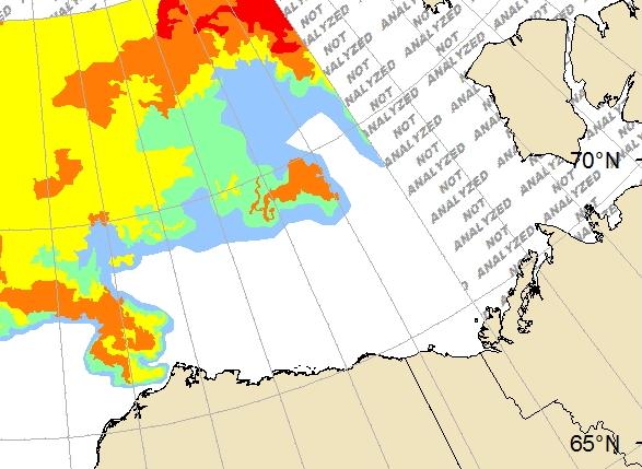
She’s currently heading out into the Beaufort Sea before following in the giant footsteps of the cruise liner Crystal Serenity in the direction of the Amundsen Gulf and the Canadian Arctic Archipelago. Here’s the United States National Weather Service’s current ice chart for Alaskan waters:
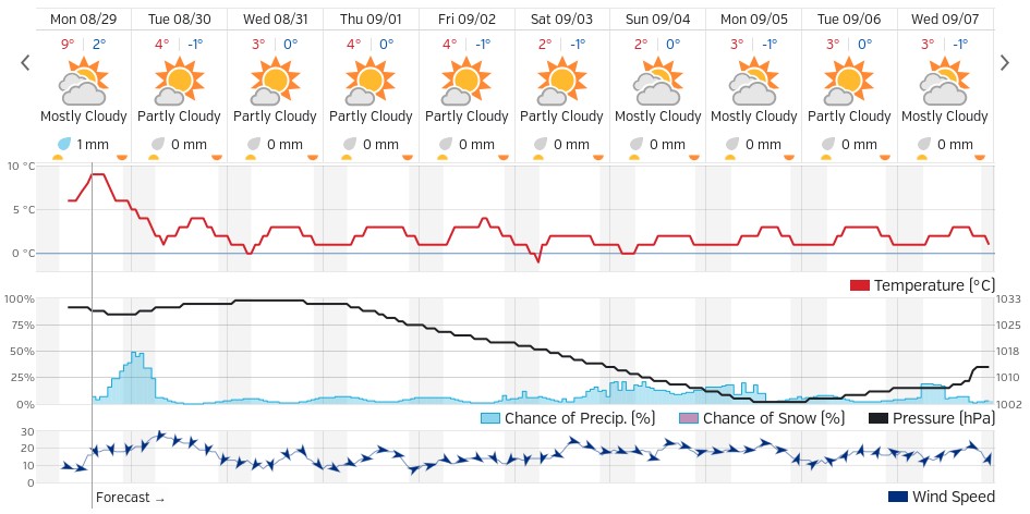
There looks to be far less to worry about ice wise on the next leg of the Polar Ocean Challenge than on the previous one! The weather forecast isn’t too bad either, with high pressure over the Beaufort Sea and a fair bit of sunshine. Here’s the Weather Underground forecast for Ulukhaktok, Crystal Serenity’s first port of call in the CAA:
There is currently a “small craft advisory” warning in effect for the Beaufort Sea coast:
CAPE HALKETT TO FLAXMAN ISLAND-
207 PM AKDT MON AUG 29 2016
…SMALL CRAFT ADVISORY IN EFFECT FROM TUESDAY MORNING THROUGH
TUESDAY AFTERNOON…
TONIGHT
E WINDS 20 KT. SEAS BUILDING TO 4 FT.
TUE
E WINDS 25 KT. SEAS 5 FT.
TUE NIGHT
E WINDS 20 KT. SEAS 6 FT.
WED
E WINDS 20 KT. SEAS 6 FT.
WED NIGHT
E WINDS 20 KT. SEAS 5 FT.
THU
NE WINDS 20 KT. SEAS 4 FT.
THU NIGHT
NE WINDS 15 KT. SEAS 4 FT.
FRI
N WINDS 10 KT. SEAS 2 FT.
SAT
N WINDS 15 KT. SEAS 3 FT.
All in all it looks like fairly plain sailing for the foreseeable future, with only occasional moderate headwinds to contend with.
[Edit – August 30th]
It seems my “fairly plain sailing” conclusion was overly hasty. According to the latest “Ship’s Log“:
The weather forecast is pants. A 30/35 knot headwind along the coast . No one has the appetite for it, so we are heading North, slacker winds, staysail out, still a choppy sea and uncomfortable, but not as bad as 30 knots. Hopefully no ice tonight on my watch.
This is the end result:
As Phil points out below:
Our next stop along the North West Passage is Tuktoyaktuk. That’s when we can use a pontoon, get rid of our rubbish, fill the tanks, do the laundry and have a shower. 500nm away.
[Edit – August 31st]
The Polar Ocean Challenge team report via Twitter:
They have some more to carry out in Tuk too. Despite the great “groove” displayed above Ben Edwards reports that:
Joy of joys, the auto-helm’s stopped working. Dad (Steve Edwards, crew), thinks he knows why so we’ll hopefully be able to fix it in Tuk. In the meantime we’re back to helming by hand. This is a mixed blessing, on the one hand it’s really irritating to have to helm in large swells and with a strong headwind because any movement you make is at first ignored, and then exaggerated by, the wind. So it’s hard to keep a decent track and it makes it harder to look out for ice. On the other hand, moving and putting effort into the steering keeps you warm which is nice and it means you don’t have to put as many clothes on which is also nice because when you go down stairs and it’s twenty four degrees it can get quite uncomfortable.
We all had our job lists, ice lights, bilge pumps, laundry, shopping but the man who gets the Vodka Salute is unquestionably Steve.
I dropped him off wth Willard. Two peas in a pod. They made a broken Pilot Spigot. That sounds quite easy but it took the whole day in a machine shop in a container, working to fine tolerances, and many modifications. Fitting it in the bowels of the Lazzerette in cold weather and driving rain. It worked first time. Brilliant effort.
Issued 07:00 AM MDT 04 September 2016
Today Tonight and Monday
Wind – Northwest 15 knots diminishing to light late this morning then becoming northwest 15 Monday morning.
Waves
Seas – 1 metre.
Weather & Visibility – Chance of showers changing to periods of rain near noon then to chance of showers tonight and Monday. Fog patches dissipating early this evening.
My famous last words? Plain sailing by the look of it!
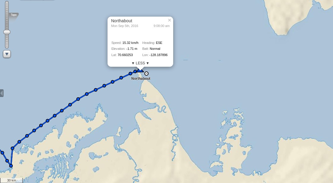
[Edit – September 5th]
Northabout has just rounded Cape Bathurst, the northernmost point of mainland Northwest Territories:
I wonder if her crew will take a close look at the nearby Smoking Hills?
[Edit – September 6th]
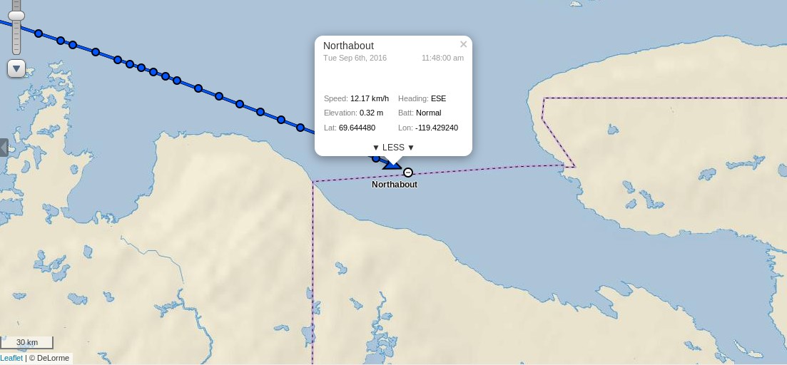
Northabout gave the Smoking Hills a miss and headed strait for Cape Parry. She has already crossed the Amundsen Gulf and is heading into the Dolphin & Union Strait:
In light of the lack of ice and in the spirit of saving time we’ve decided not to stop in Cambridge Bay or Pond Inlet and go straight on to Upernavik in Greenland before doing our crew change. Looking at the ice maps at the moment it seems we’ll be able to get through with little or no trouble, though this is almost bound to change, if it stays that way we’ll reach Upernavik in about fourteen days. I’m looking forward to it!
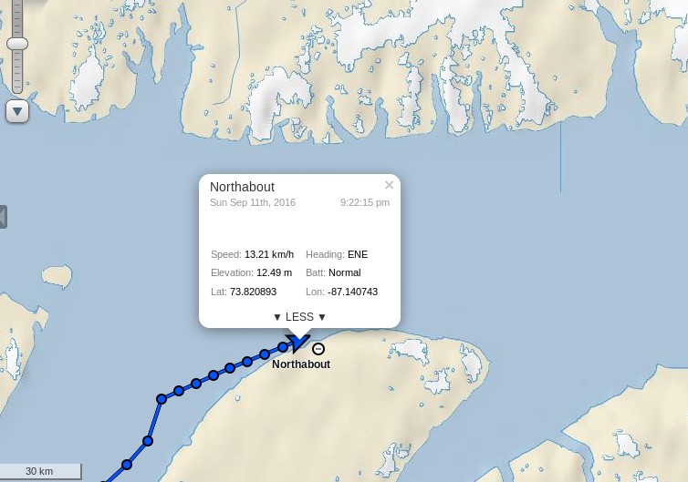
This morning Northabout is rapidly approaching the western entrance to Bellot Strait:
Their stated intentions are to head past Pond Inlet and across Baffin Bay to Upernavik in Greenland. Assuming they initially follow the same route as Crystal Serenity they will soon to need to pick their way past some bergy bits in Prince Regent Inlet before negotiating some currently “wispy” areas of sea ice as they enter Lancaster Sound. Here is the current Canadian Ice Service chart for the area:
plus a rather cloudy “visual” image:
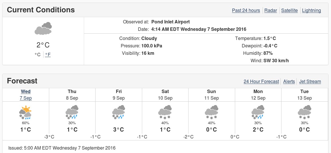
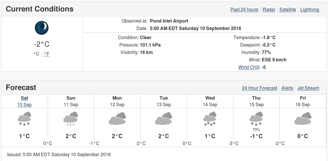
The current weather forecast for Pond Inlet doesn’t suggest the parts of the Northwest Passage still on Northabout’s route are going to start refreezing just yet:
Currently there is an obvious passage past the existing ice, but that may of course have changed by the time Northabout gets there.
[Edit – September 10th PM]
Northabout has just emerged safely from the eastern end of Bellot Strait:
I wonder if her crew will stop to make a new entry in the visitors book at Fort Ross?
[Edit – September 11th]
Here’s the latest CIS ice chart:
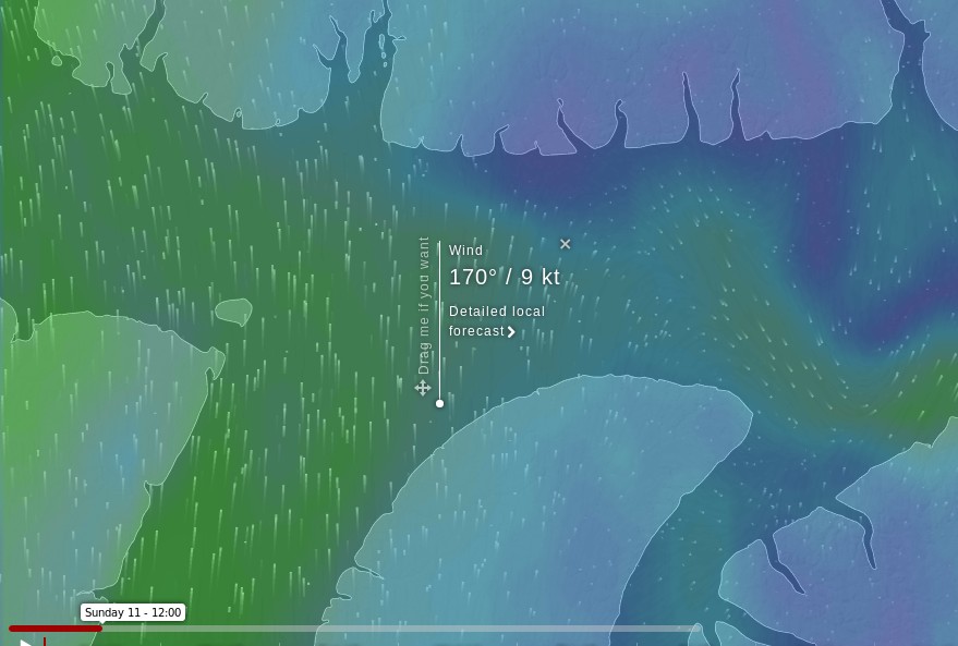
The gap between the coast and the yellow area of 4-6/10 concentration ice has closed considerably, and there’s now a broad expanse of 1-3/10 ice which Northabout may be forced to try and wend her way through. A change in wind direction would come in very handy, and that’s just what the ECMWF forecast at Windyty is suggesting for Sunday 11th:
Just what the doctor ordered?
[Edit – September 11th PM]
Video shot from Northabout’s drone of her ice-free passage through Bellot Strait:
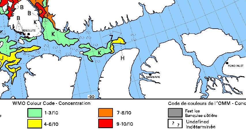
However the passage from Prince Regent Inlet into Lancaster Sound has not proved to be ice-free!
Northabout is obviously endeavouring to skirt around the eastern edge of the 4-6/10 old ice in her path:
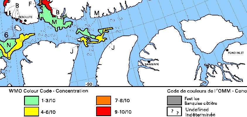
Today’s CIS ice concentration chart suggests there isn’t much room to spare:
The stage of development chart does reveal some new ice, but it’s well to the north of Northabout’s route through Lancaster Sound to Pond Inlet:
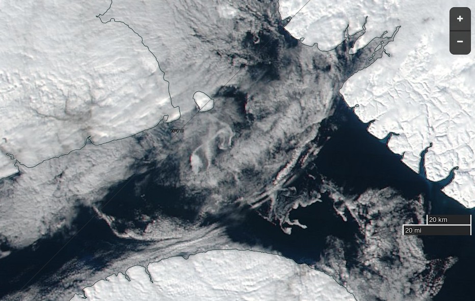
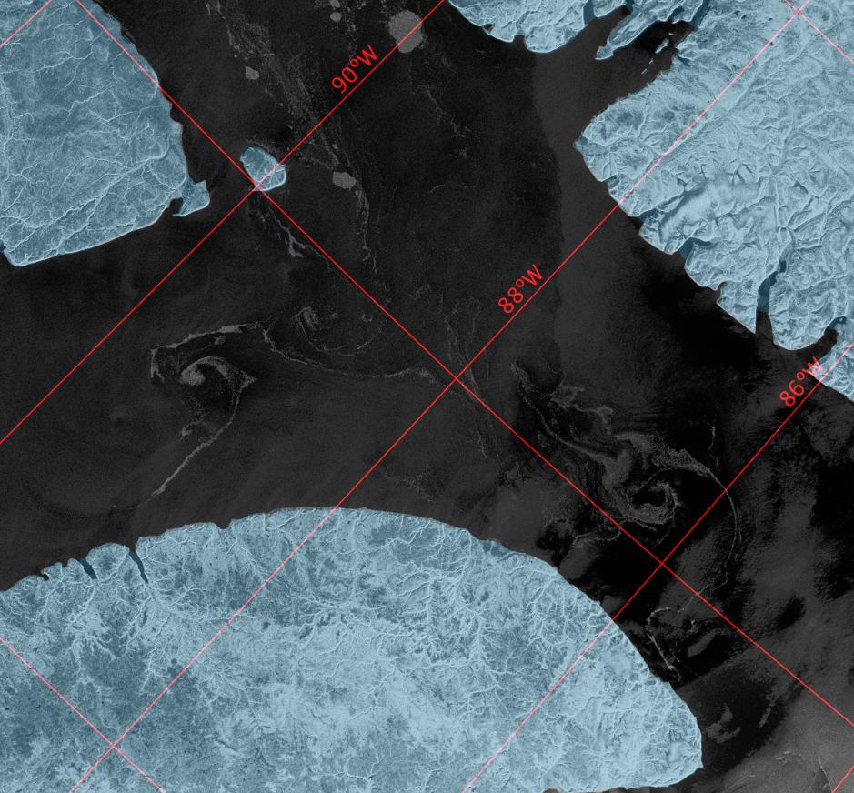
Somewhat belatedly, here’s a Sentinel 1A synthetic aperture radar image of the sea ice Northabout is squeezing past as we speak:
[Edit – September 12th]
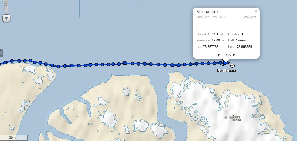
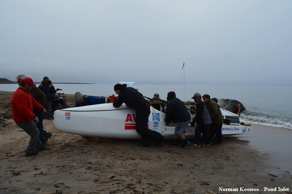
Northabout has emerged safely into Lancaster Sound, and is bypassing Pond Inlet in order to head strait across Baffin Bay:
Here are a couple of videos of some remnants of sea ice on her once again eastward travels:
There are several more on the Polar Ocean Challenge web site.
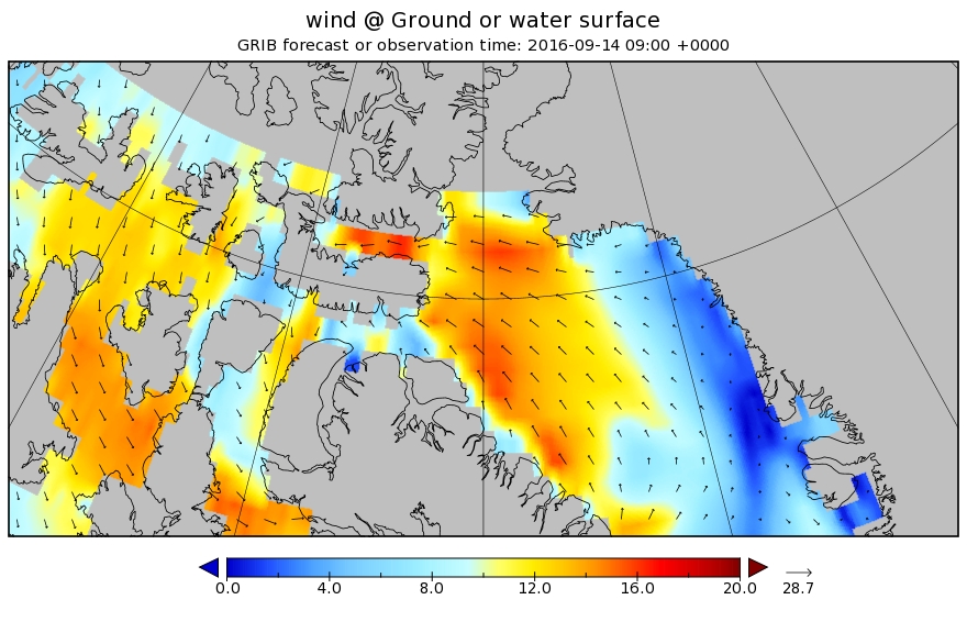
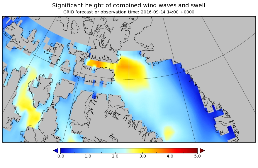
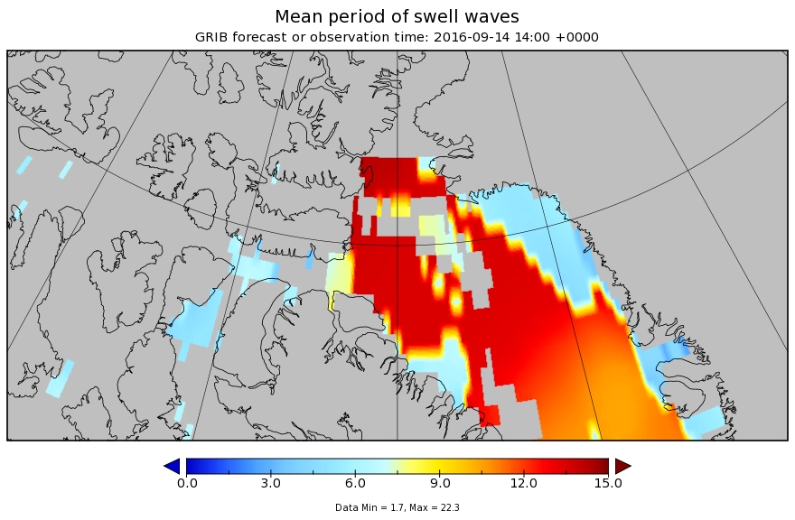
With all that ice now safely behind her Northabout has new dangers to face. Wind and waves! Let’s take a look at the WaveWatch III “surf forecast” for Baffin Bay over the next few days. A low pressure area is heading in Northabout’s direction from across the Canadian Arctic Archipelago. By Wednesday morning (UTC) the resultant wind field looks like this:
By Wednesday afternoon those winds of around 15 m/s will have produced waves in Baffin Bay that are forecast to have reached over 3 meters high:
and what’s more they won’t be just wind waves. A modest swell with a period of over 12 seconds is predicted too:
I’m sure the Polar Ocean Challenge team will be doing their level best to be safely on the opposite side of Baffin Bay by the time the worst of the weather arrives!
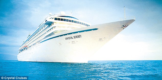
We first mentioned the cruise ship Crystal Serenity in our initial musings about prospects for the Northwest Passage in 2016. Since then the sea ice has melted on a variety of the “southern” routes through the Northwest Passage, and the Crystal Serenity has now set sail for the Arctic. Amongst the over 1000 passengers there is even a blogger:
We’re thrilled to have travel journalist Katie Jackson “joining the crew” for this voyage. Katie, an acclaimed writer and avid traveler, will be providing dispatches from the ship…or tundra, or zodiac, to help all of you indulge your wanderlust.
The Crystal Serenity is equipped with a number of webcams. Here’s the current view from one as the Crystal Serenity is en route to Nome Alaska:
It looks a bit breezy up there at the moment, but nothing to trouble the 68,000 ton Crystal Serenity. However Crystal Cruises do seem to be anticipating some potential problems. Accompanying the Crystal Serenity will be the British Antarctic Survey icebreaker Ernest Shackleton, which is already making its way through the Northwest Passage from the direction of the Atlantic Ocean:
The RRS Ernest Shackleton, operated by British Antarctic Survey, is an ICE 05 classed icebreaker (exceeding the more common 1A Super class) that will provide operational support to Crystal Serenity, including ice breaking assistance should the need arise and carry additional safety and adventure equipment.
The RRS Ernest Shackleton will carry two helicopters for real-time ice reconnaissance, emergency support and flightseeing activities. In addition to its robust ice navigation and communications equipment, the RRS Ernest Shackleton will have on board supplemental damage control equipment, oil pollution containment equipment, and survival rations for emergency use.
Hopefully none of that emergency equipment will need deploying over the next two weeks or so, but that is far from certain. Listen to what Admiral Charles Michel, Vice Commandant of the United States Coast Guard, had to say in testimony before the House Subcommittee on Coast Guard and Maritime Transportation in answer to questions from Congresswoman Janice Hahn:
I don’t want to underestimate the challenges of that area. There is almost no logistics up there. For example if we needed to get another helicopter up there they’re only bringing a very small helicopter with them. If we needed to get a big helicopter up there it’s estimated it would take between 15 and 20 hours, if the weather’s good, in order to get that up there. Fixed wing aviation may be available, but even there you’ve got very limited landing areas, very environmentally sensitive areas, things change up there dramatically even during the summer. The weather is an incredible challenge, so this is not an easy category for a voyage.
If you’re interested in US Arctic policy in general you may wish to watch the whole 2+ hours of the hearing instead. In which case, here it is!
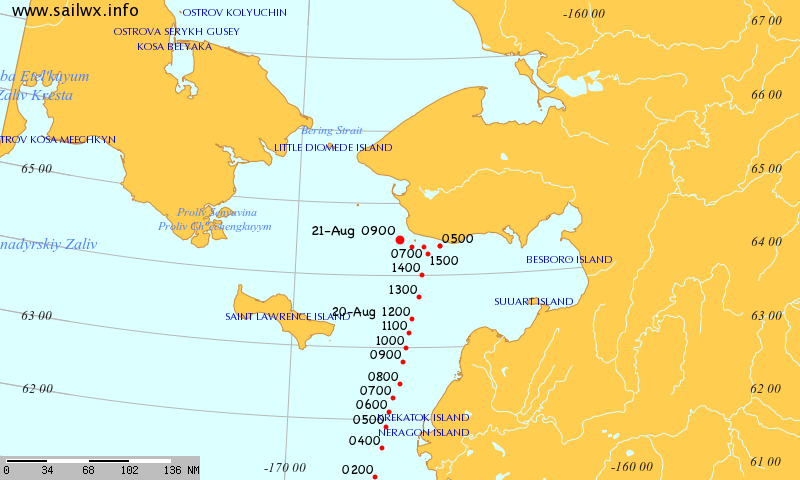
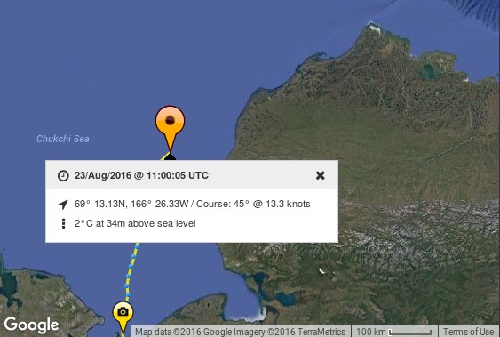
[Edit – August 23rd]
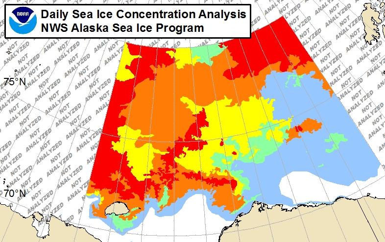
Crystal Serenity is now inside the Arctic Circle, and rapidly approaching her first potential problem:
Here is the latest National Weather Service ice chart for Alaskan waters:
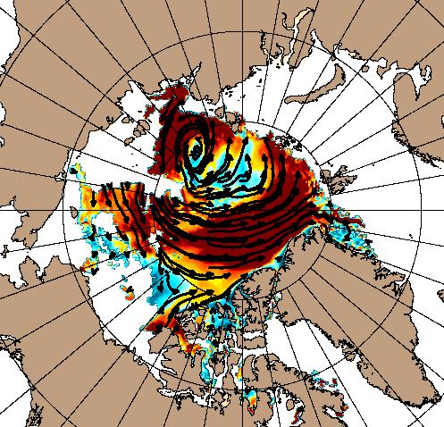
It shows 1-3 tenths coverage all the way to shore at Point Barrow. What’s more with the Great Arctic Cyclone still raging the current US Navy forecast is for continuing onshore ice drift:
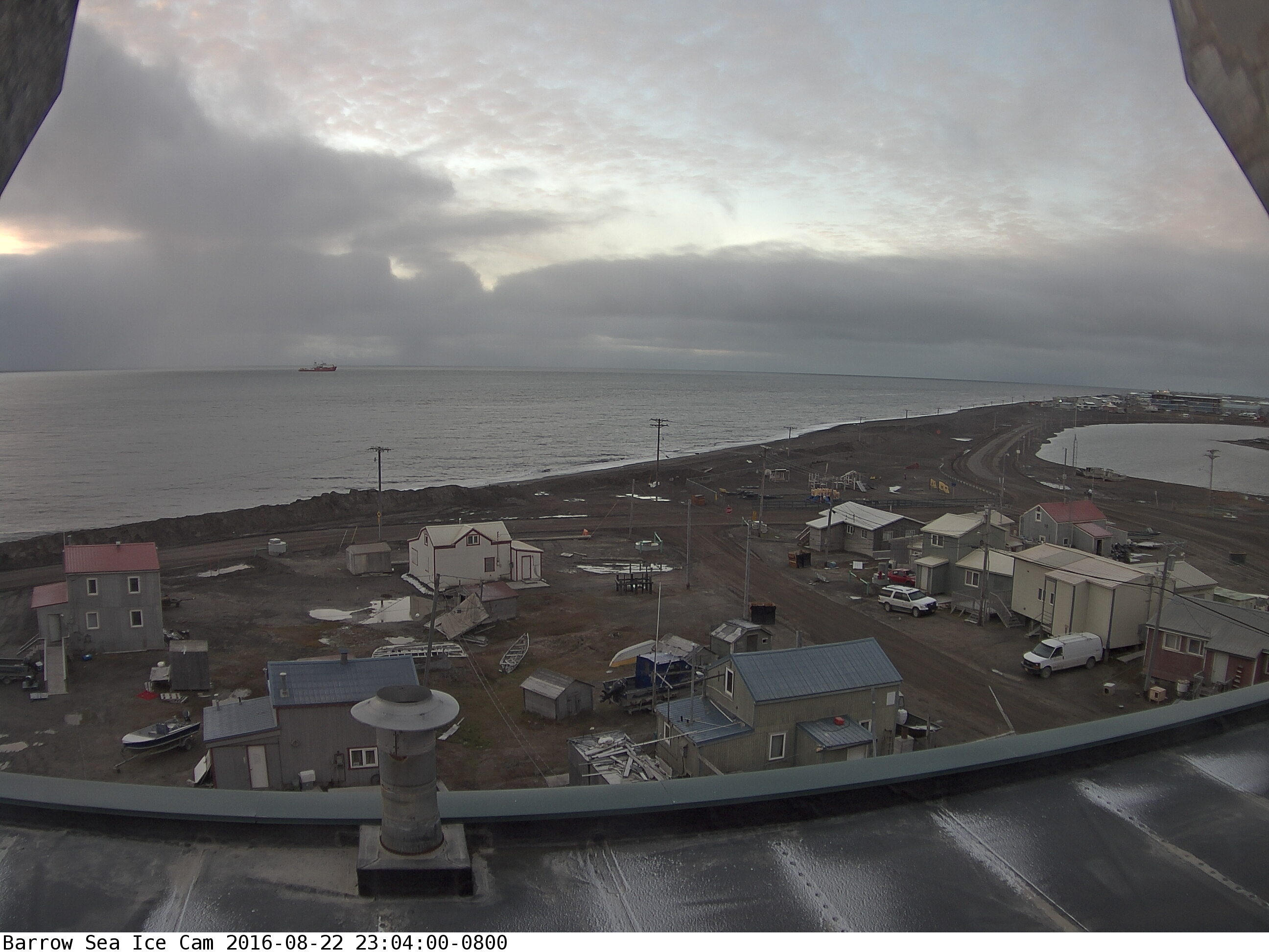
Maybe that’s why there seems to be an icebreaker patiently waiting offshore at Barrow as we speak?
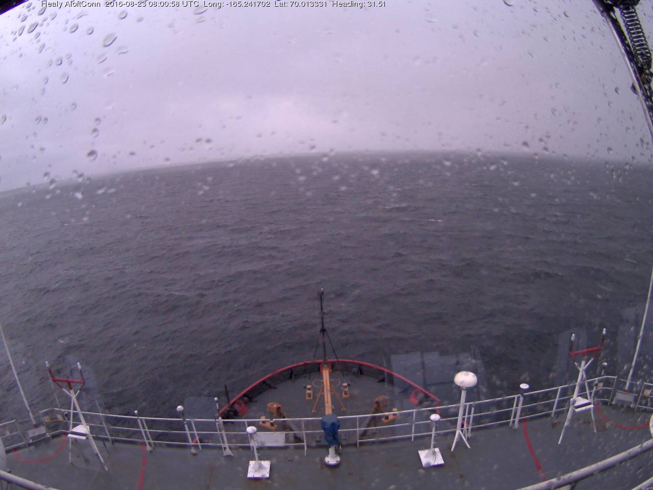
As luck would have it USCGC Healy is in the vicinity too, albeit slightly south of Barrow. The weather in the Chukchi Sea doesn’t look too good at the moment:
[Edit – August 24rd]
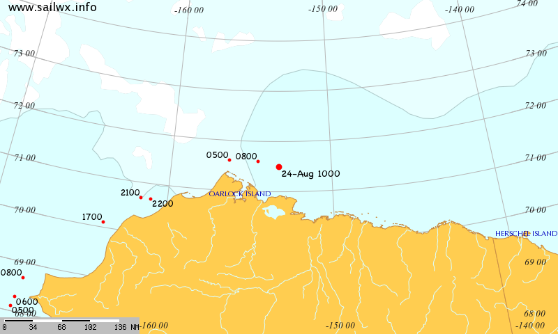
Crystal Serenity has rounded Point Barrow, apparently without incident. Here’s her tracking map from SailWX:
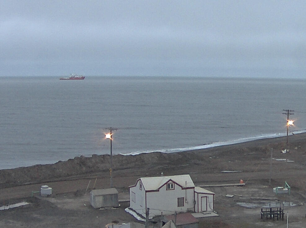
Apparently icebreaker assistance was not required since the ship anchored off Barrow, which looks a lot like the Korean icebreaker Araon, seems not to have moved:
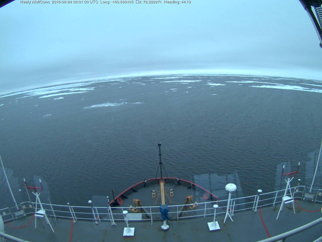
Rather disappointingly the Crystal Serenity’s webcams seem to update infrequently and have yet to reveal any sea ice. The Healy aloftcon camera, however, recorded this image from 72 degrees north:
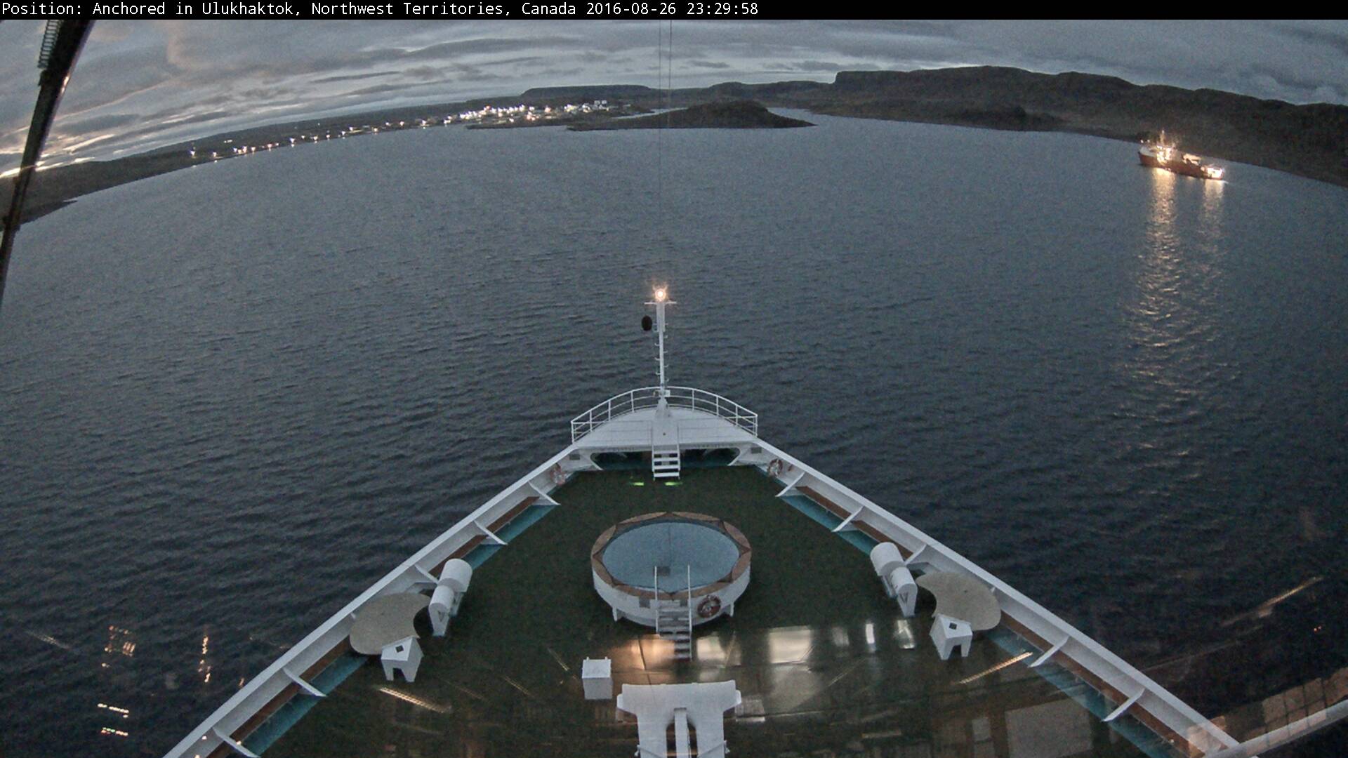
[Edit – August 27th]
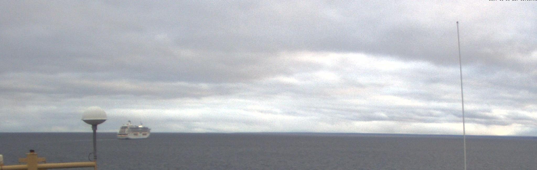
Crystal Serenity has reached Ulukhaktok on the west coast Victoria Island, and met up with the Ernest Shackleton:
It doesn’t look as though any ice breaking will be required in the near future!
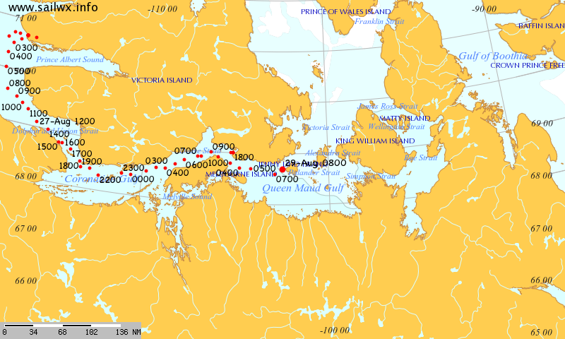
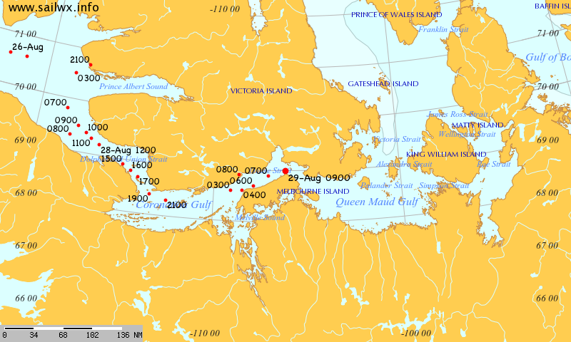
[Edit – August 29th]
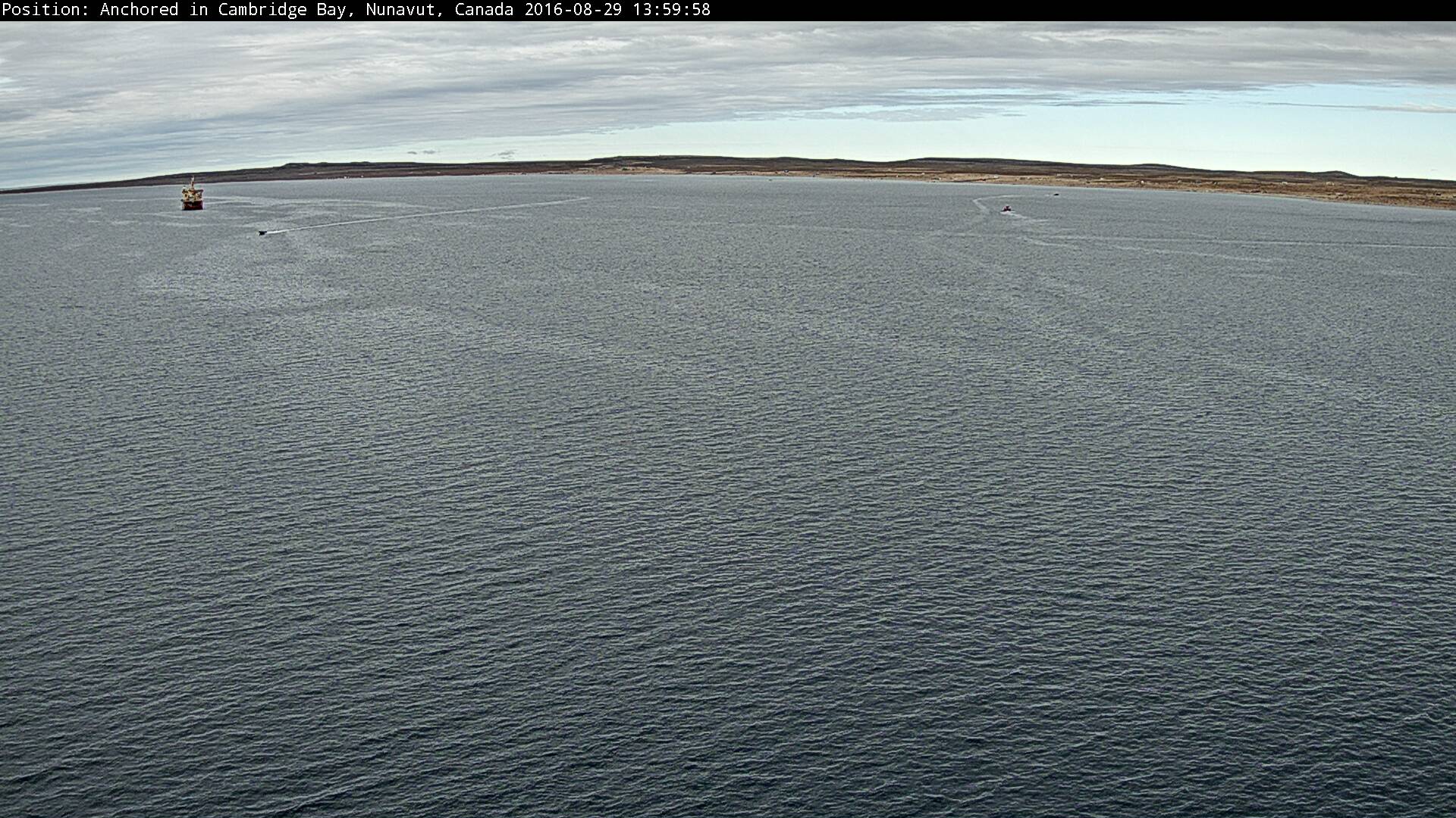
Crystal Serenity and Ernest Shackleton are both now in Cambridge Bay:
There is no ice to be seen!
The next stage of Crystal Serenity’s itinerary involves “Cruising Peel Sound or The Bellot Strait”. I wonder which option she’ll take?
The early morning paid off quickly with our first Polar bear sighting! And what an experience it was. This apex predator patrolled calmly on an ice floe, and put on quite a show stretching, scanning and keeping watch for any potential prey.
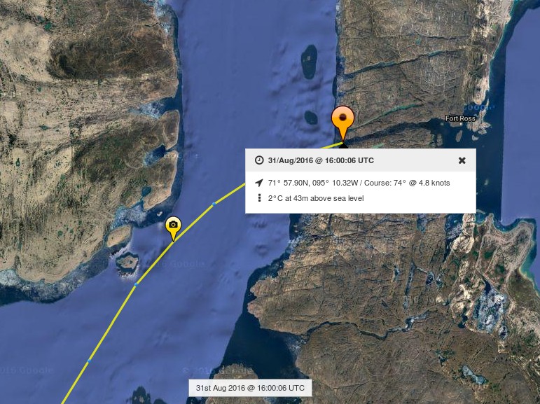
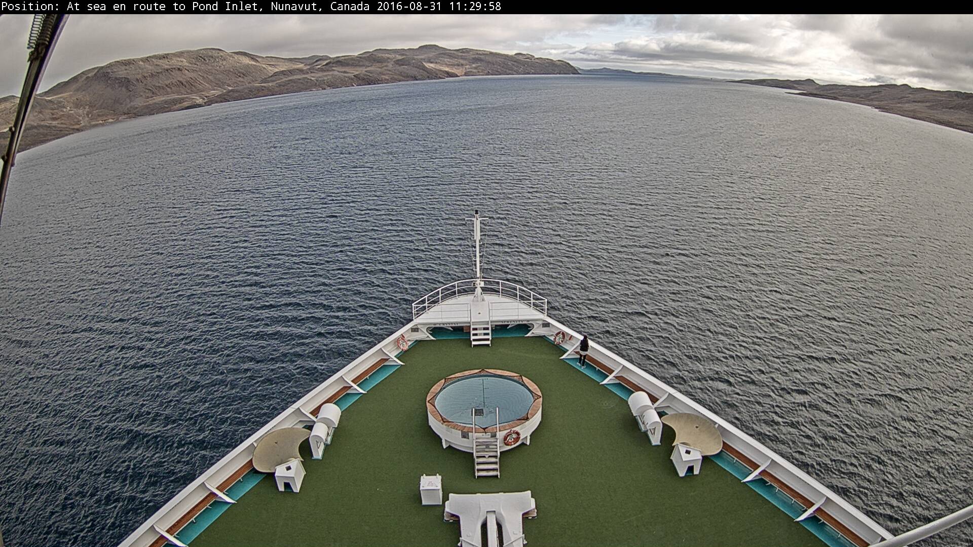
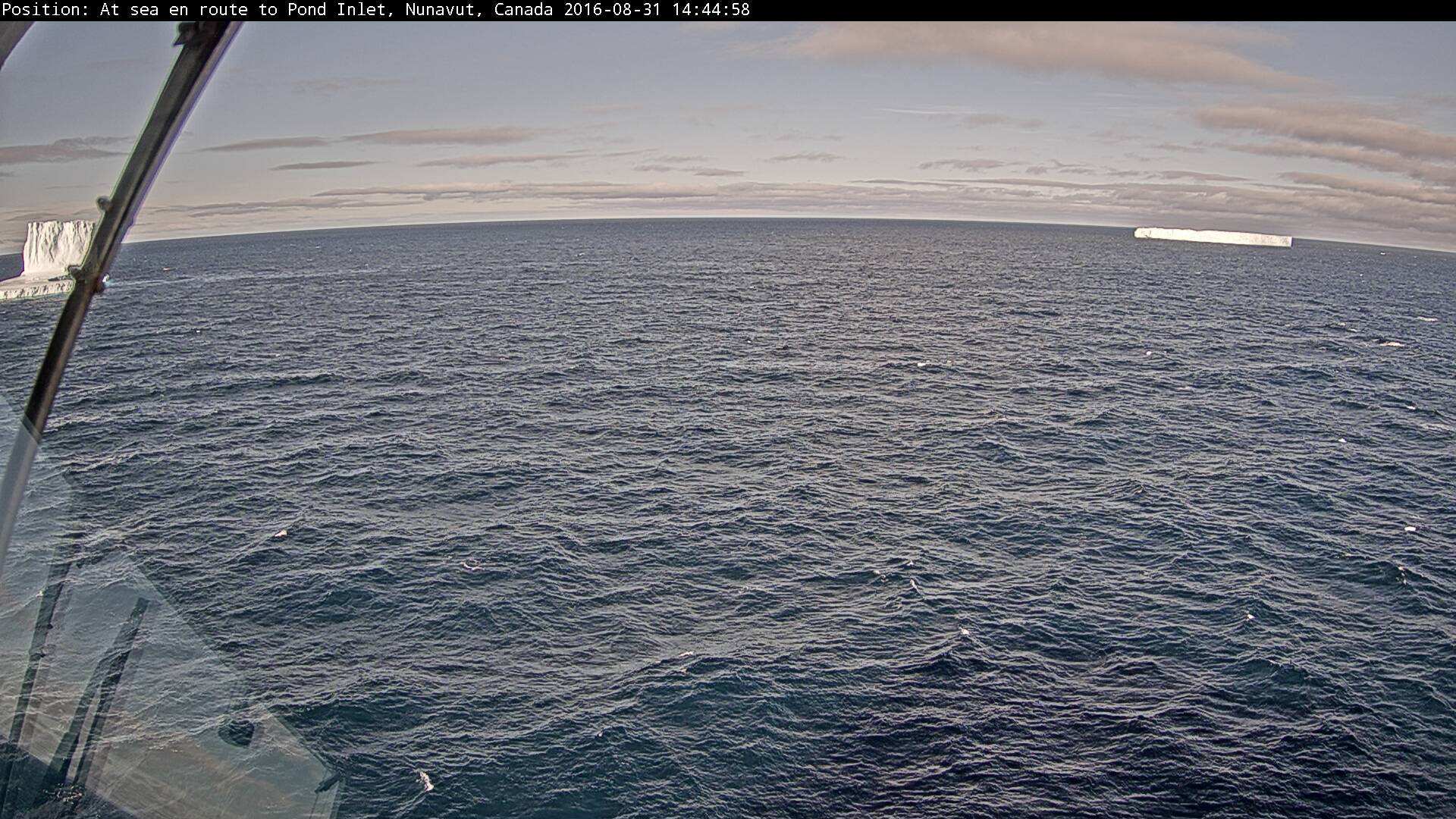
[Edit – August 31st]
Crystal Serenity has evidently decided to cut through Bellot Strait:
Here’s the view from the bridge:
No sea ice to be seen!
P.S. Having emerged from the eastern end of Bellot Strait some bergy bits could be seen in the Gulf of Boothia:
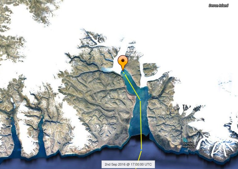
[Edit – September 2nd]
Crystal Serenity has been taking a good long look at a glacier today:
Judging by her tracking map it’s the North Croker Bay Glacier on Devon Island:
I wonder if that’s where those bergy bits came from?
Our coverage of the Northwest Passage is starting somewhat earlier then usual in 2016. That’s because an educational comment of mine seems to have gone permanently missing over at Andrew Montford’s blog. Over there commenter “Golf Charlie” suggested that:
Perhaps based on rumours, or folk stories, the possibility of a North West Passage, was the answer to many peoples dreams of wealth, fame and fortune. The Franklin Expedition set off, with all confidence, knowing that there had been an unprecedented retreat in Arctic sea ice extent. They never came home. The ships then sent to rescue them, never came home either, but some survivors did.
In July 2010, due to unprecedented ice loss, a team set out to find HMS Investigator, (one of the rescue ships) and found her within 15 minutes, exactly where she was trapped and abandoned. How had she got there?
This may be just a load of boring and irrelevant history to you, but as an ice expert keen to lecture others, it just seems strange that you don’t acknowledge the fact that before man made CO2 emissions could possibly had any remote chance of shrinking sea ice, it had all happened before.
It is likely that whatever caused the ice to retreat in the 1830s/40s, may have caused the current retreat. As no attempt has been made to explain this historical retreat, it seems premature to jump to conclusions about the present. What stories and folklore convinced Franklin there was a NWP? Had it opened before? Did the Vikings circumnavigate the North Pole? No one knows for sure.
Here’s the beginnings of my by now expanded reply:
I am already very familiar with the sorry tale of Franklin’s ill fated expedition. By way of some more recent Northwest Passage history, were you previously aware that Charles Hedrich completed his own multi-year voyage through the NWP last summer? His vessel was much smaller than Franklin’s:
“He is now, the first man to have rowed solo the North-West Passage.”
It’s not terribly clear, but apparently Charlie thinks his “unprecedented ice loss” in the Summer of 2010 had a precedent in the 1840s and/or 50s. Perhaps he will pop in and elucidate? Whilst we wait to see what transpires in that regard, here’s an animation of sea ice concentration across the Northwest Passage last summer:
My missing comment also referenced (by way of example!) a 2015 academic journal paper entitled “Ice thickness in the Northwest Passage“. Amongst its other conclusions can be found this:
Global climate models with their coarse resolution likely have difficulty capturing intricate sea ice dynamic processes within the narrow channels of the CAA. Specifically, the import, survival, and thickness of MYI are difficult to predict and may in fact increase during the transition to a sea ice-free Arctic with more mobile ice conditions in the Queen Elizabeth Islands which are located between the Arctic Ocean and NWP. Presumably, MYI from the Arctic Ocean will be more heavily ridged and thicker than locally formed MYI, posing greater danger to transiting ships than locally grown MYI.
Whilst we look forward to the prospects of the “transition to a sea ice-free Arctic”, what about the prospects for the Northwest Passage in the summer of 2016. As you can see from the video there wasn’t much in the way of multi-year sea ice left there by the Autumn of 2015, and there doesn’t seem to have been much transport of ice into the Canadian Arctic Archipelago over the winter either.
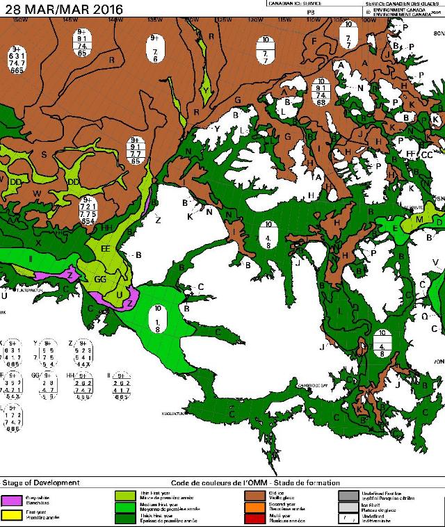
On top of the ice there will of course be some snow by now. Here’s how the Topaz 4 snow cover map of the area looks at the moment:
All in all it looks to me at this early stage of the 2016 Arctic sea ice melting season as though one or more of the assorted routes through the Northwest Passage will be open again this coming summer. Do you suppose that will look like yet another “unprecedented retreat” to “Golf Charlie’s” eyes?
It seems as though a large commercial organisation sees things that way too. Crystal Cruises have concluded that in 2016 the Northwest Passage offers:
The ultimate expedition for the true explorer!
Anchorage to New York on Crystal Serenity
DATES : August 16 – September 17, 2016 (32 Days) CRUISE-ONLY FARES FROM : $21,855 Per Person
More than 18 months of careful planning and analysis has already gone into this project from January 2013 to July 2014, and will continue up to, and through, departure.
There will not be shore-based cell phone signals along the transit, except in the communities and towns we will be visiting. However, guests are requested to not use this signal when in port, as it will overwhelm the local system and disrupt the communication within the community.
While communication channels may be temporarily limited or unavailable to guests, the ship’s Captain and crew will always have operational and emergency communication throughout the entire voyage.
This website uses cookies to improve your experience. We'll assume you're ok with this, but you can opt-out if you wish. Cookie settingsACCEPT
Privacy & Cookies Policy
Privacy Overview
This website uses cookies to improve your experience while you navigate through the website. Out of these, the cookies that are categorized as necessary are stored on your browser as they are essential for the working of basic functionalities of the website. We also use third-party cookies that help us analyze and understand how you use this website. These cookies will be stored in your browser only with your consent. You also have the option to opt-out of these cookies. But opting out of some of these cookies may affect your browsing experience.
Necessary cookies are absolutely essential for the website to function properly. This category only includes cookies that ensures basic functionalities and security features of the website. These cookies do not store any personal information.
Any cookies that may not be particularly necessary for the website to function and is used specifically to collect user personal data via analytics, ads, other embedded contents are termed as non-necessary cookies. It is mandatory to procure user consent prior to running these cookies on your website.