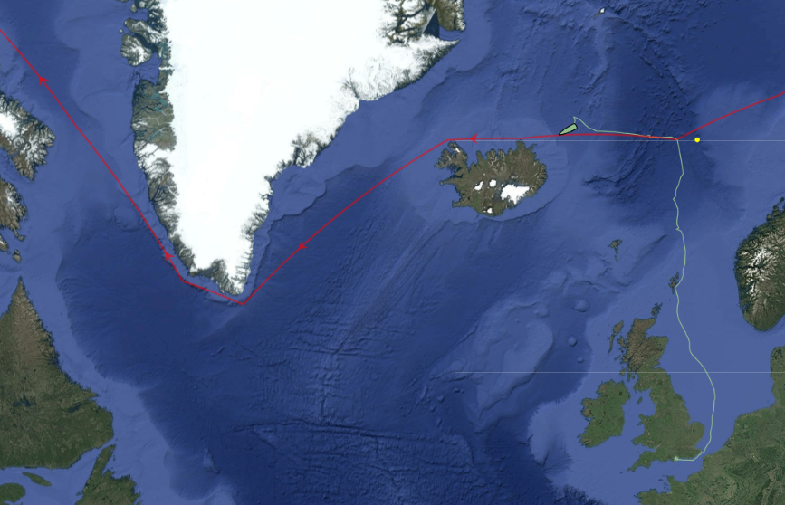
I mentioned the start of Ella Hibbert‘s long voyage in her yacht Yeva over on this year’s Northwest Passage thread. Ella and Yeva have now crossed north of the Arctic Circle near Iceland and have begun their attempt to circumnavigate the Arctic in a single summer by sailing past the north of Iceland in a westerly direction:
Arctic explorer Pen Hadow trekked, and swam, from Ward Hunt Island to the North Pole in 2003. Solo and unsupported. He plans to return to the North Pole this summer, but on this occasion he’ll be sailing with a few companions. According to yesterday’s Sunday Times:
Pen Hadow launches bittersweet mission to sail to North Pole
For his new record attempt, Hadow and his nine-strong team will take two yachts on a 3,500-mile round trip from Nome in Alaska to the pole, using satellites to find a route through the ice and avoid getting stuck. He will fly to Alaska to join his team members on Saturday.
If all goes to plan, he will arrive at the pole between August 15 and early September, about 510 miles further north than anyone has sailed before.
Although the Sunday Times failed to mention it the expedition has a web site of its own. According to the Arctic Mission “About” page:
Arctic Mission sets off from Nome in Alaska (USA) in the first week of August. The expedition team will not see land again for six weeks. We will cover about 3,500 miles by the time they return to harbour at Nome in mid-September.
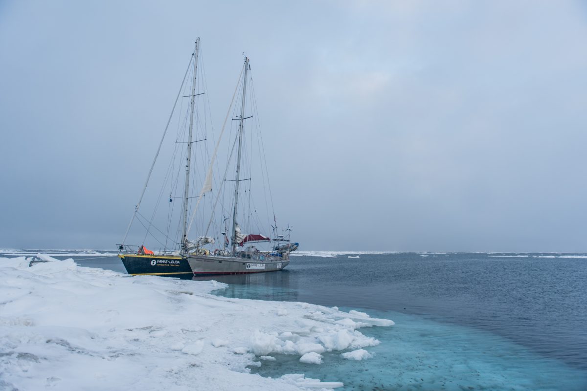
Our two 50 foot yachts, Bagheera and Snow Dragon II, are specially built to sail in waters with sea ice, and the four skippers, two on each boat, are exceptionally experienced in polar seas, and with navigation and safety procedures in sea ice.
The Arctic Mission team intend to do lots of science during their attempt to reach the Pole:
Our expedition is going to explore, discover and share the stories of the spectacular marine wildlife – plants, animals and even bacteria – that lives around the North Pole. Be prepared to be surprised!
We’ll also be doing essential scientific studies and sharing this information, so that our international policy-makers can decide how best to #protect90North.
The more we explore this unexplored ocean, the better we will understand how it works, which means we can make the best decisions to protect it for the benefit of everyone for ever.
We’ve met the two yachts in question before. In 2015 Bagheera and Snow Dragon II both successfully negotiated the Northwest Passage. However this voyage will be far more difficult. During their attempt to sail to the North Pole in the summer of 2013 Sébastian Roubinet and Vincent Berthet had to be rescued by the Russian icebreaker Admiral Makarov when the Central Arctic refreeze set in earlier than originally anticipated. Unlike the ice skating catamaran Babouchka, Bagheera and Snow Dragon II both have engines which will certainly help avoiding a similar fate. In addition perhaps the sea ice in the Arctic is less of an obstacle than it was in 2013? In an interview with the BBC World Service on Sunday Pen pointed out that:
Now 40% of the international waters around the North Pole, what we call the Central Arctic Ocean, are open water in the summer time.
When asked:
Do you think you’ll actually achieve this goal then?
Pen replied:
I think it’s quite possible, with the assistance of a US agency that have satellites that are going to be helping us each day pick the best route through these ever narrowing cracks, and it’s quite possible that we’ll reach the North Geographic Pole.
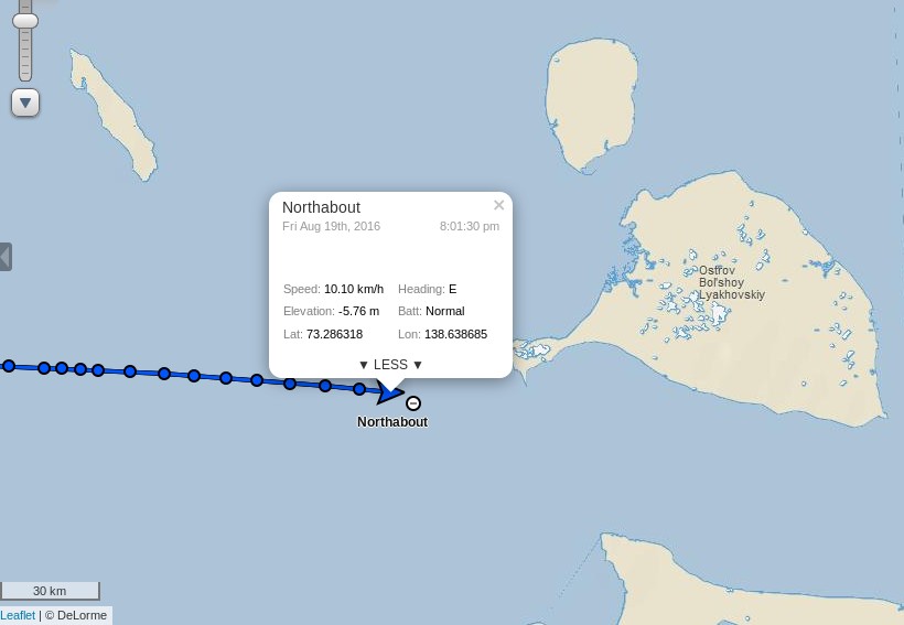
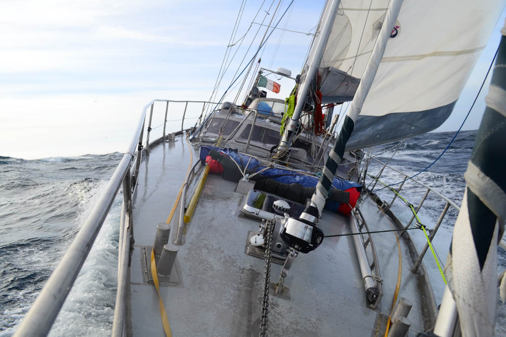
I also trust that the Arctic Mission team will be keeping a close eye on the Arctic weather forecast over the next month or so. Last August the crew of the yacht Northabout feared for their lives when caught in an Arctic cyclone in a sheltered anchorage on the Northern Sea Route. There is no such safe haven anywhere near the North Pole.
Pen concluded his BBC interview as follows:
If we can produce a visual image of a sail boat at 90 degrees north I think that could become an iconic image of the challenge that the twenty-first century faces. Are we serious about running this planet, which is actually what we need to start doing, and it’s biophysical resources on a sustainable basis, or are we just here for a laugh?
We wish him and the Arctic Mission team well. Watch this space for further updates, and possibly that iconic visual image! Meanwhile here’s a picture of Bagheera in the Northwest Passage in 2015:
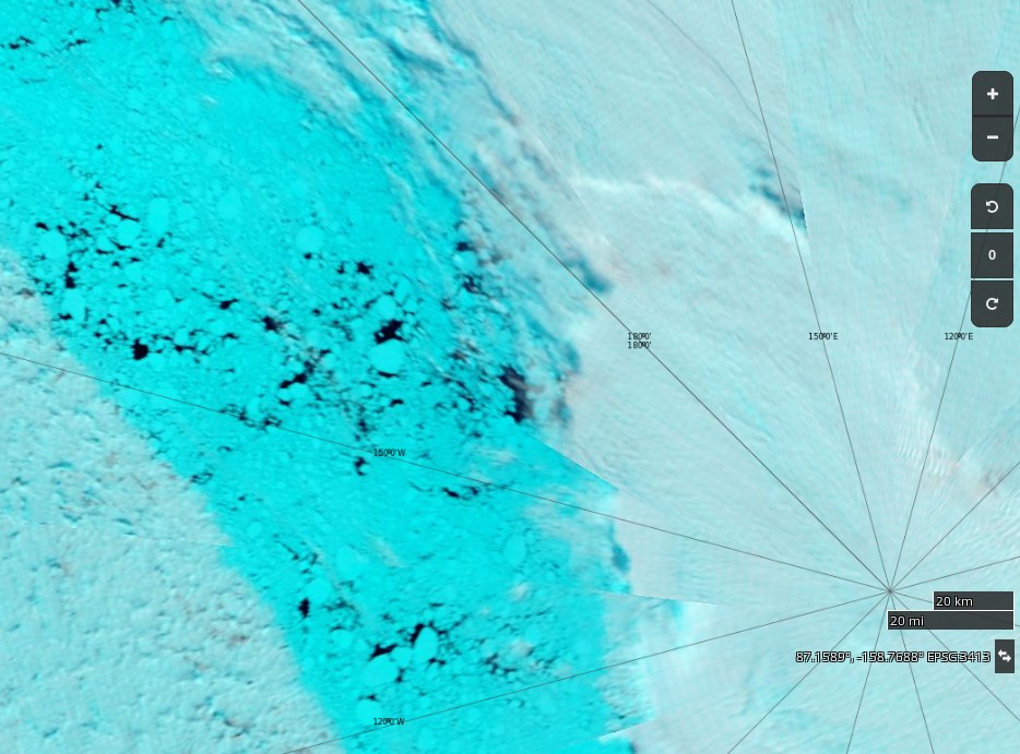
plus an image from the Sentinel 1B satellite of the current state of the Arctic sea ice on the direct route from Nome to the North Pole:
Sentinel 1B image of Arctic sea ice at 86N, 180W on July 24th 2017
There don’t seem to be many “narrow cracks” just yet.
[This] brings us to the summer of 2016, and an idea I was mulling over. A rather Big Idea. Had the deterioration of the Arctic sea ice got to a point where switching from Spring-time sledge-hauling to Summer-time sailing was appropriate? In my solo journey from northern Canada to the North Geographic Pole in 2003, I had spent over 30 hours swimming open water stretches, out of the total 850 hours spent hauling my sledge while walking on skis across the sea ice. It had dawned on me then that global warming was the likely cause of so much open water. Since then, it has become highly unlikely that the ski route from northern Russia to the Pole will be done again, due to the absence of sea ice for most of the year off the Severnaya Zemlya island group. And the other classic route from northern Canada no longer has an aircraft operation to provide the necessary support for sea ice expeditions, due to the worsening quality of the sea ice. Both routes have now been lost to the Arctic Ocean’s fast-changing environment. And with this change, the Arctic Ocean with its hitherto frozen summer surface is now rapidly becoming open-access to surface vessels for the first time in human history.
Would it be possible to sail a small yacht to the Pole? Could that create a useful platform to share the unfolding situation with a global audience? Might this be the best way I could focus world attention on the merit of creating a new marine reserve in the international waters surrounding the North Pole?
It looks like we’re just about to find out the answer to those questions. The team have also announced another livestream from Nome, Alaska. This one is scheduled for 8 PM BST tomorrow, Thursday August 10th. They say:
Ahead of our Friday departure (weather permitting – there’s a nasty storm brewing over the Bering Strait that may prove problematic) we’d love to introduce you to the Arctic Mission team.
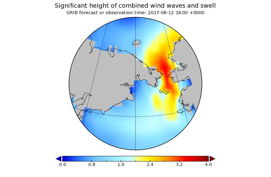
This is probably what they are referring to:
A bumpy ride for Pen Hadow et al. is in store on Saturday, and some big waves for Utqiaġvik (Barrow as was) as well.
[Edit – August 13th]
An overly brief and (hence?) rather misleading article in the Sunday Times today. According to Jonathan Leake:
Sailing to North Pole will have to wait
Pen Hadow, the British explorer, is today due to start a sailing expedition across the Arctic Ocean to highlight the effects of climate change, including an attempt to reach the North Pole.
Scientists warned, though, that despite the rapid melting of the ice there was unlikely to be access to the North Pole via open water for some years.
Professor Mark Serreze, director of America’s National Snow and Ice Data Centre, said the North Pole was still surrounded by nearly 800 miles of solid pack ice as of last week.
Jonathan appears not to have a particularly good grasp of sea ice (thermo)dynamics during the latter stages of the summer melting season!
NASA Worldview “false-color” image of the North Pole on August 13th 2017, derived from the MODIS sensor on the Terra satellite
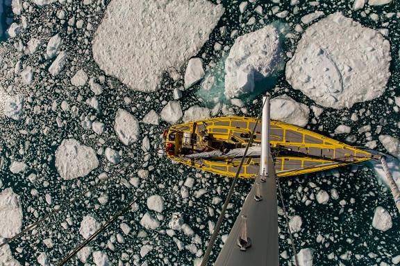
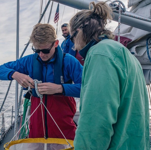
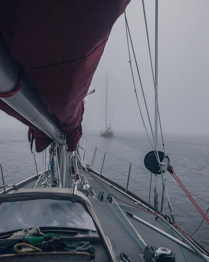
Whilst waiting for the waves in the Bering Strait to die down Conor McDonnell, Arctic Mission’s photographer, has recorded a video from the top of Bagheera’s mast, amongst other places:
[Edit – August 14th]
According to Pen Hadow Bagheera and Snow Dragon II will set sail in the small hours of tomorrow morning (UTC):
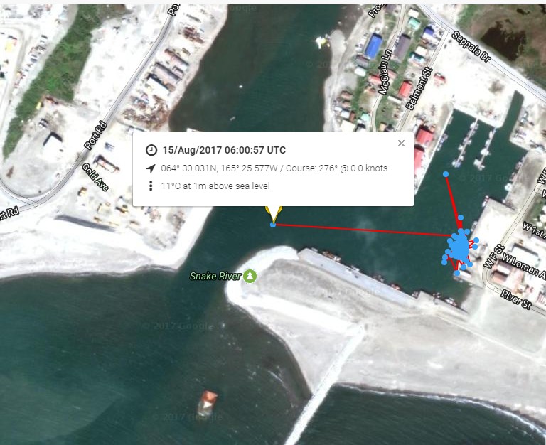
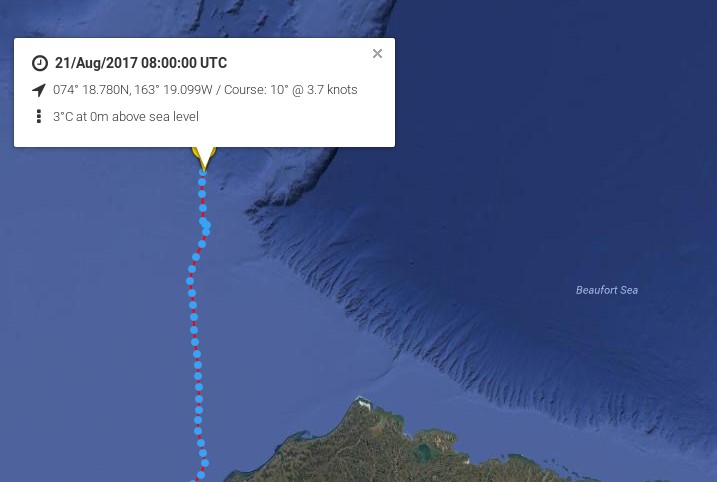
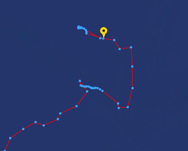
The Arctic Mission live tracking map is operational at last. Here is what it reveals so far:
It looks as though Bagheera and Snow Dragon II left Nome on their voyage of discovery at 06:00 UTC this morning.
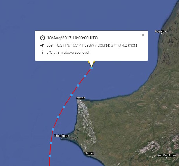
[Edit – August 18th]
Point Hope is now behind the Arctic Mission team:
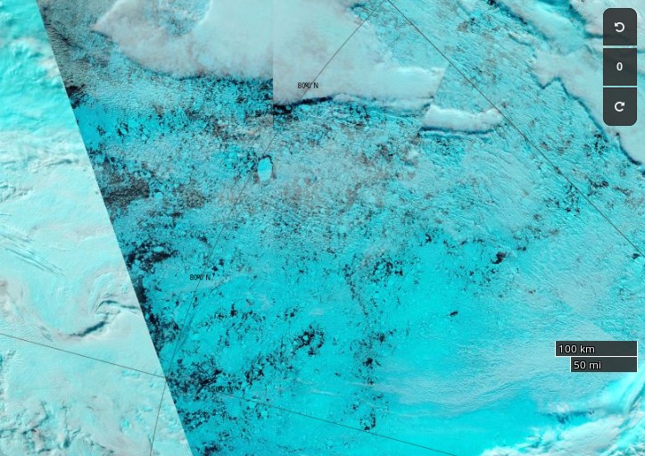
Next is Point Lay. Much further north, there are significant gaps appearing in the sea ice up to around 83N:
NASA Worldview “false-color” image of the Central Arctic north of the Beaufort Sea on August 18th 2017, derived from the MODIS sensor on the Terra satellite
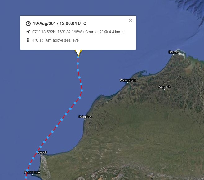
[Edit – August 19th]
Bagheera and Snow Dragon II are obviously not heading for the Northwest Passage in 2017!
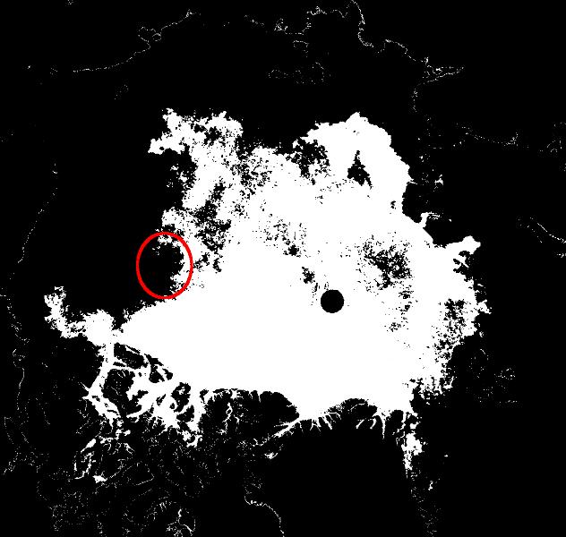
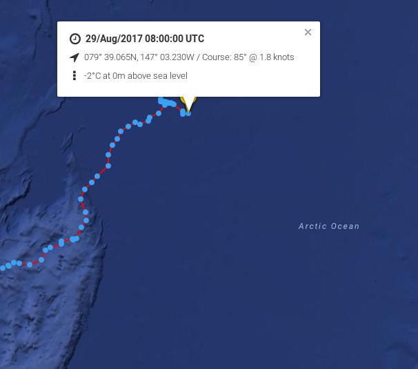
Arctic Mission’s furthest North was 80 degrees 10 minutes North, 148 degrees 51 minutes West, reached at 22:04:12 (Alaskan Time, GMT-9hours) on 29 August 2017 by yachts, Bagheera and Snow Dragon II.
Arctic Mission moored its yachts to an ice floe on 29 August to conduct one of its 24-hour marine science surveys, while drifting with the sea ice. The strategy for any future northward progress had been to monitor the sea surface currents, sea ice, and weather conditions (both observed from the yachts and through satellites imagery downloaded onto our computers), and decide how to proceed as we approached the end of the 24-hour survey.
A meeting of the four skippers was held led by Erik de Jong, with Pen Hadow present, and it was agreed further northward progress would increase considerably the risks to the expedition, with very limited scientific reward. The decision to head south, back to an area of less concentrated sea ice in the vicinity of 79 degrees 30 minutes North, was made at 18.30 (Alaskan time).
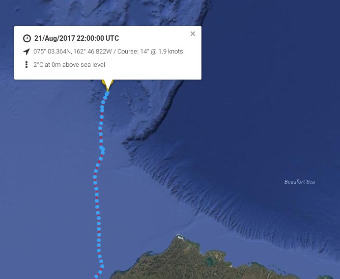
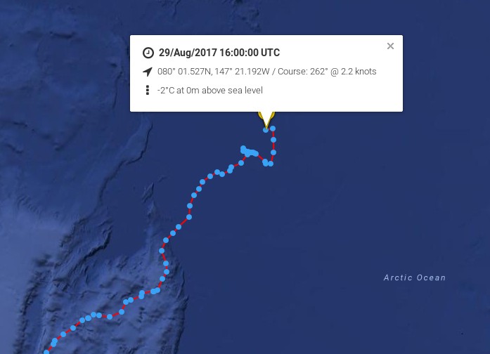
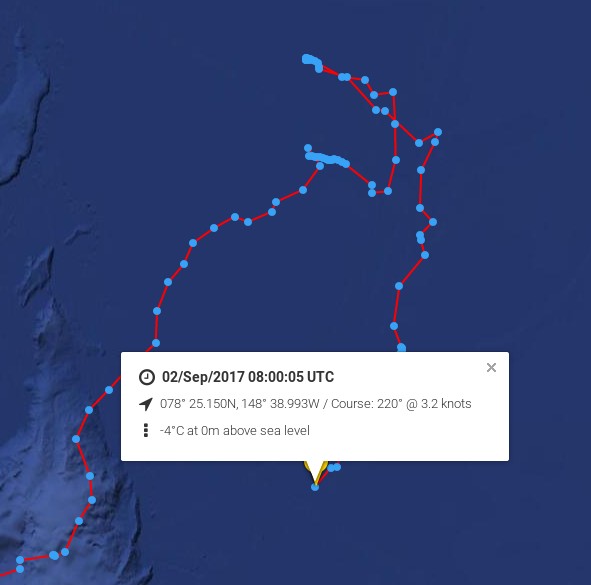
Here’s the live tracking map from 06:00 UTC this morning:
A prudent and not unexpected decision. Cue the cackling from all the usual suspects?
[Edit – August 31st]
The cackling from all the usual suspects has indeed begun. It has even inspired a somewhat surreal modern art installation! Meanwhile according to their Twitter feed:
We are slowly making our way back to Nome now after reaching the northernmost point of our… https://t.co/GhrYYza6gk
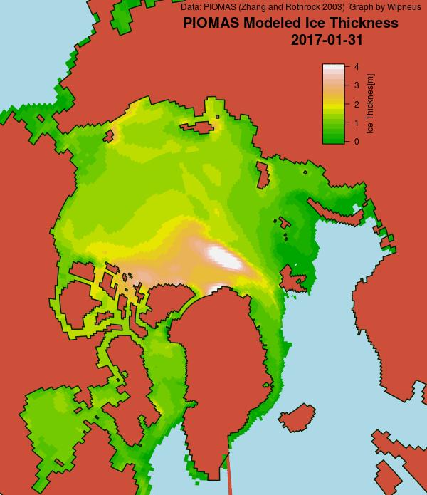
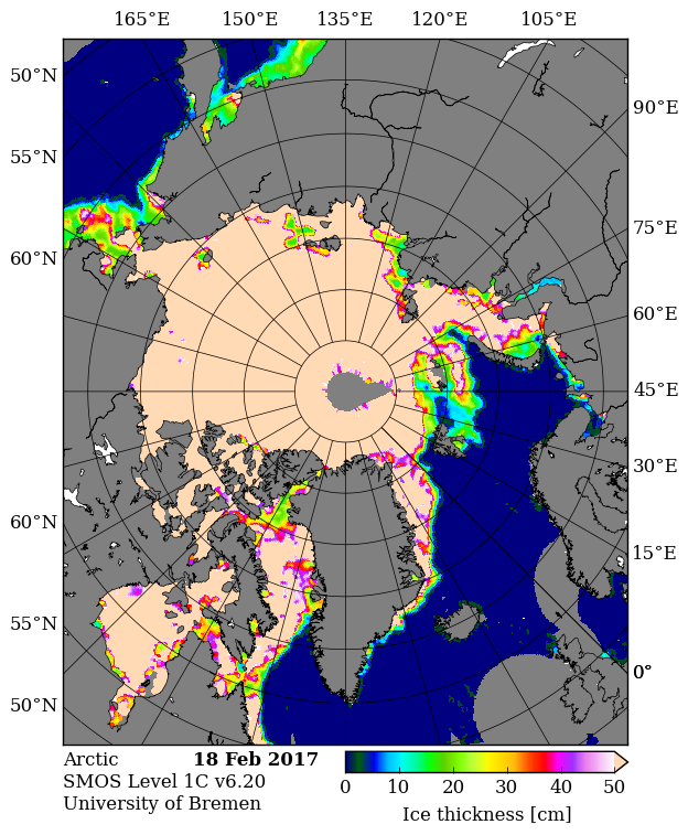
Here’s the PIOMAS gridded thickness for January 31st, courtesy of Wipneus at the Arctic Sea Ice Forum:
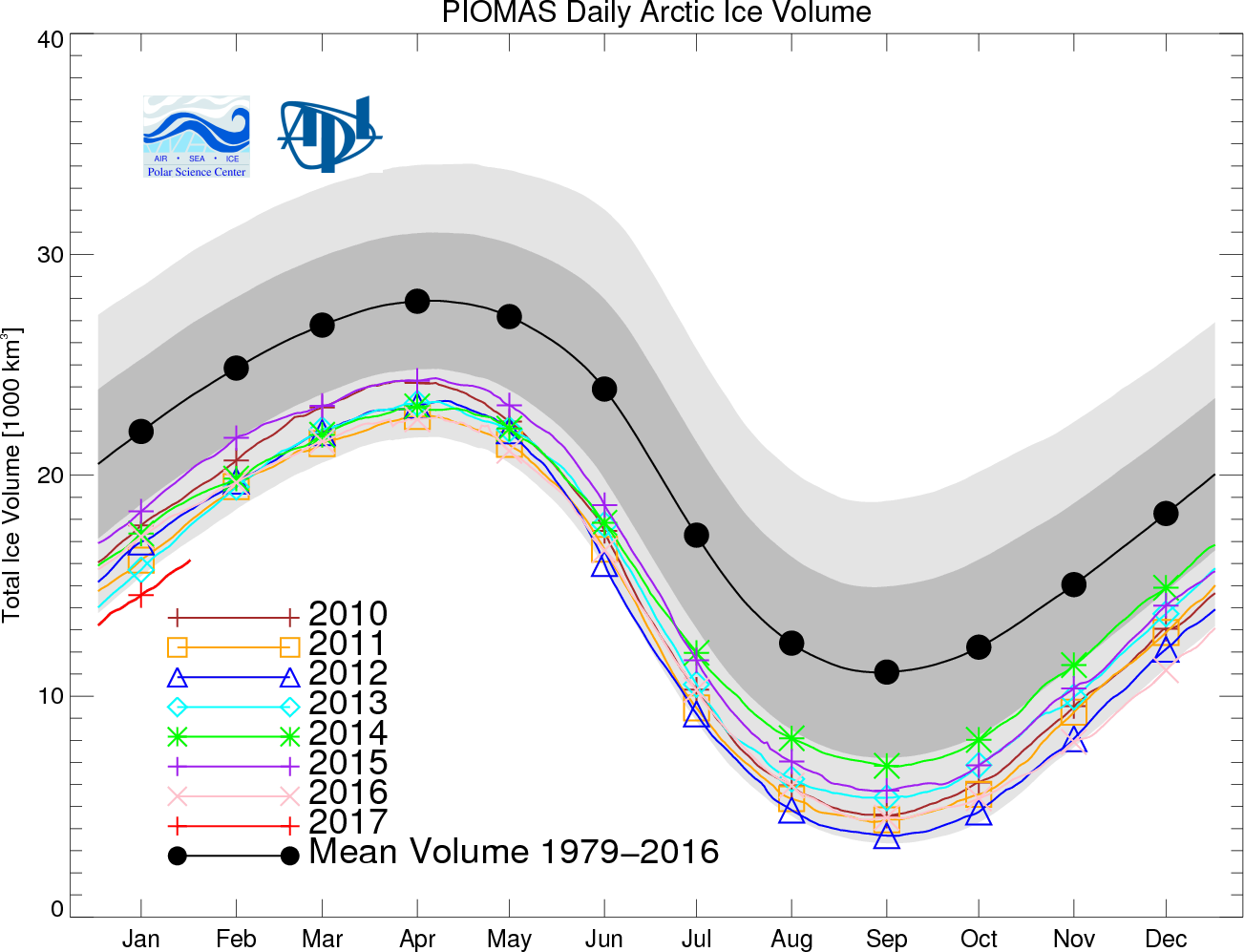
Somewhat anomalously it shows the thickest ice some distance away from the coast of Greenland and/or Ellesmere Island. Here too is Andy Lee Robinson‘s updated PIOMAS “Arctic death spiral”:
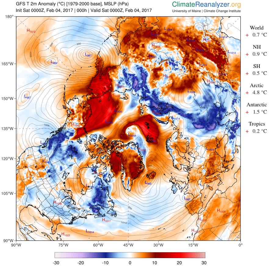
Meanwhile yet more anomalously warm air is entering the Arctic Basin from both the Pacific and Atlantic sides:
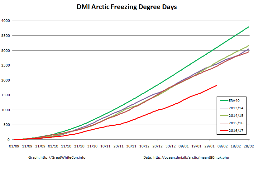
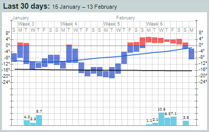
That sort of thing has happened quite a few times over the 2016/17 freezing season, as you can see from this graph of cumulative Freezing Degree Days (FDD for short):
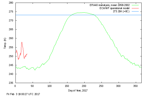
The FDD graph is based on the same data as the probably much more familiar DMI “Daily mean temperatures for the Arctic area north of the 80th northern parallel” graph:
Things are warming up in the Arctic once again.
[Edit – February 5th]
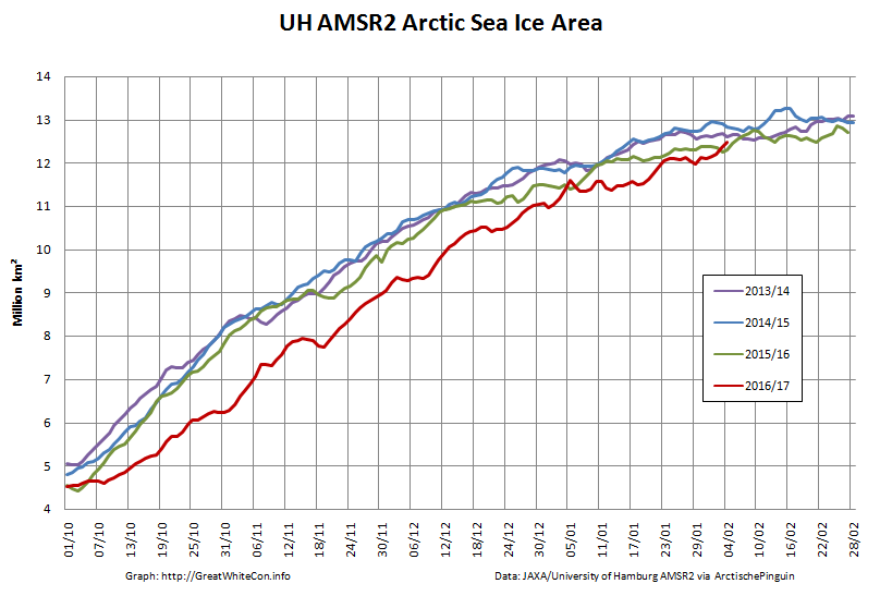
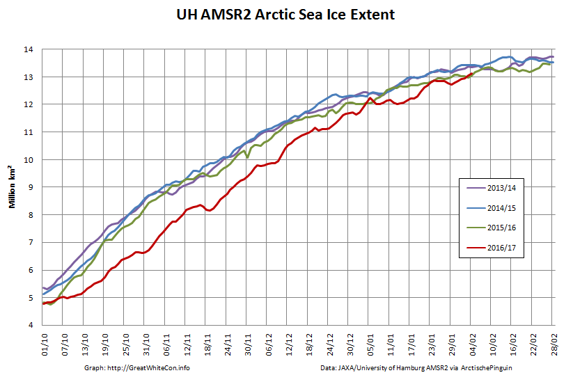
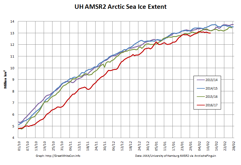
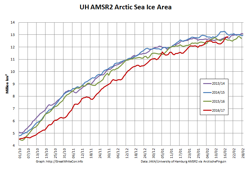
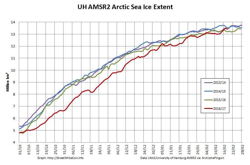
Whilst we await the arrival of the forecast anomalous warmth, how are some other metrics coming along? Here’s the high resolution AMSR2 area and extent:
It looks like they’re back in the “normal” range for now, does it not?
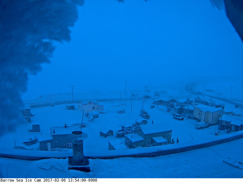
[Edit – February 6th]
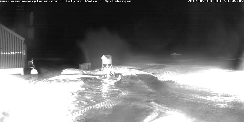
Things currently still look fairly frosty over on the Pacific side of the Arctic, as you can see from the webcam at Utqiagvik (Barrow as was):
However over on the Atlantic side (and especially for “Richard”!) melting can now be observed on Svalbard:
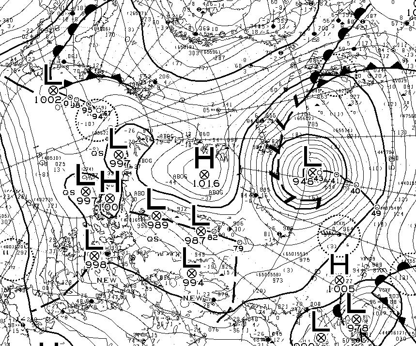
An extremely powerful cyclone off Greenland is pumping heat and moisture northwards:
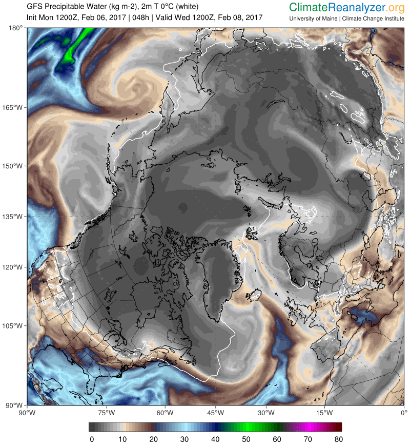
Note that the cyclone’s MSLP fell to 940 hPa earlier today. This is the GFS precipitable water forecast for Wednesday lunchtime:
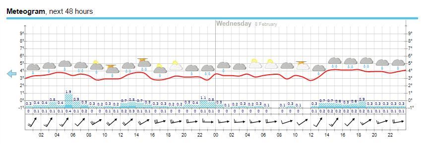
Finally, for the moment at least, here’s the current weather forecast for Longyearbyen in Svalbard:
All in all there’s plenty more heat and moisture on the way.
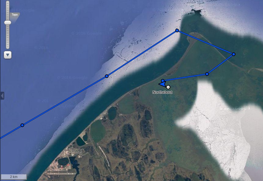
It’s time to open another chapter in the continuing adventures of Northabout. The Polar Ocean Challenge team have been plagued by sea ice along their route across the Laptev Sea, but currently they are hurrying towards the exit into the East Siberian Sea via the Dmitry Laptev Strait:
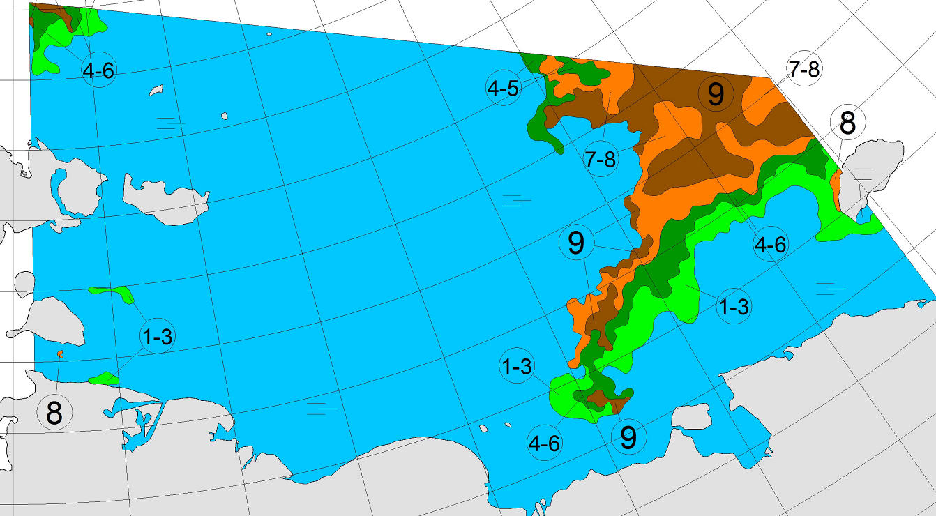
The latest chart of sea ice in the East Siberian Sea from the Arctic and Antarctic Research Institute suggest they should now have plenty of (comparatively!) plain sailing ahead of them:
Certain quarters of the cryodenialosphere have been questioning the plucky little yacht’s ability to make it through the Northwest Passage before it freezes up once again in the Autumn. As a crude reality check on that assertion let’s see how previous successful single season polar circumnavigations fared in that regard. The international date line runs through the Bering Strait, and effectively defines a boundary between the Northern Sea Route and the Northwest Passage. In 2010 Børge Ousland and Thorleif Thorleifsson in the catamaran Northern Passage crossed the date line on September 3rd:
Let’s wait and see when Northabout manages to pass that milestone, before heading to their next scheduled port of call at Barrow in Alaska.
[Edit – August 21st]
Northabout has spotted some more sea ice, this time in the Dmitry Laptev Strait. Presumably the small area shown in the AARI chart above? According to the latest “Ship’s Log”:
Well slowly making progress, and now into a new sea, East Siberian, Looks the same to be honest. Saw a ship,on the AIS , but couldn’t see it with the fog. Went between the Islands. We had a large patch of 8/10ths ice in the middle, but managed to keep north of it. Along the coast you could again see the remnants of an old Polar station. What a vast coast to look after.
Just as things were getting into a rhythm, the engine is over revving. We are so close but so far out here. My stomach is sometimes in my mouth, Comrades trying to work it out. If not, is a slow sail from here to Alaska.
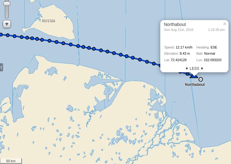
The reported engine trouble doesn’t seem to have slowed Northabout down. She crossed 150 east earlier this morning and is now passing the delta of the Indigigirka River:
[Edit – August 22nd]
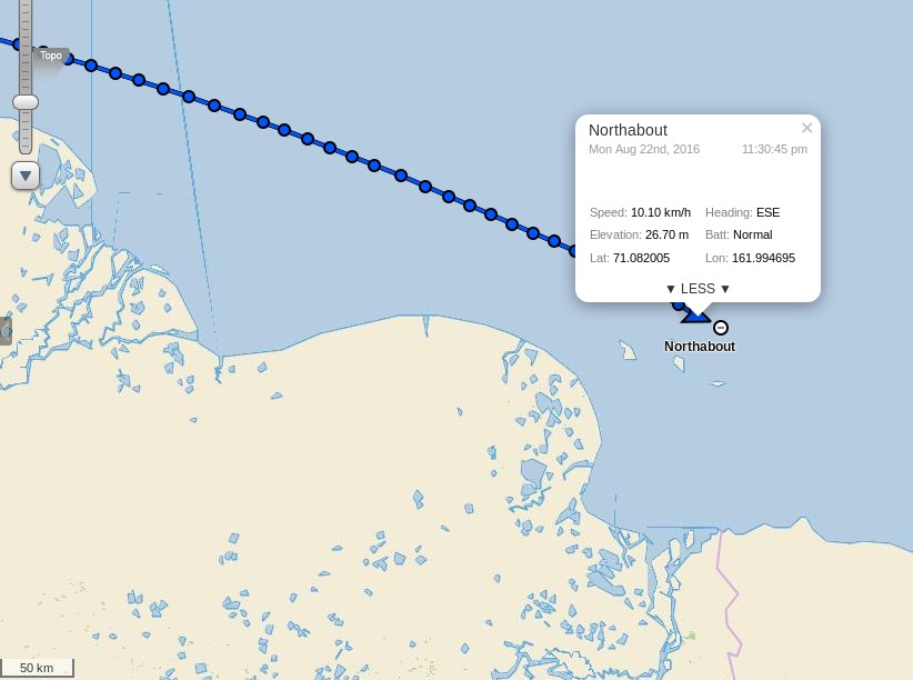
Her engine has been serviced, and Northabout continues to make good progress. She’s crossed 160 east, and is now passing the delta of the Kolyma River:
We’ve got enough wind to put the staysail out and the skies are clear. I think quite a lot of how I was feeling may have been that I hadn’t got any sunshine for over two weeks, the last couple of days however have been warm(ish) and bright. I at least am coming dangerously close to feeling actually happy, I don’t know about anyone else… Provided we continue like this we should be in Point Barrow in under a week.
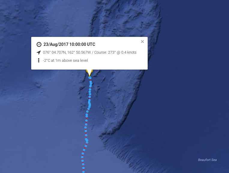
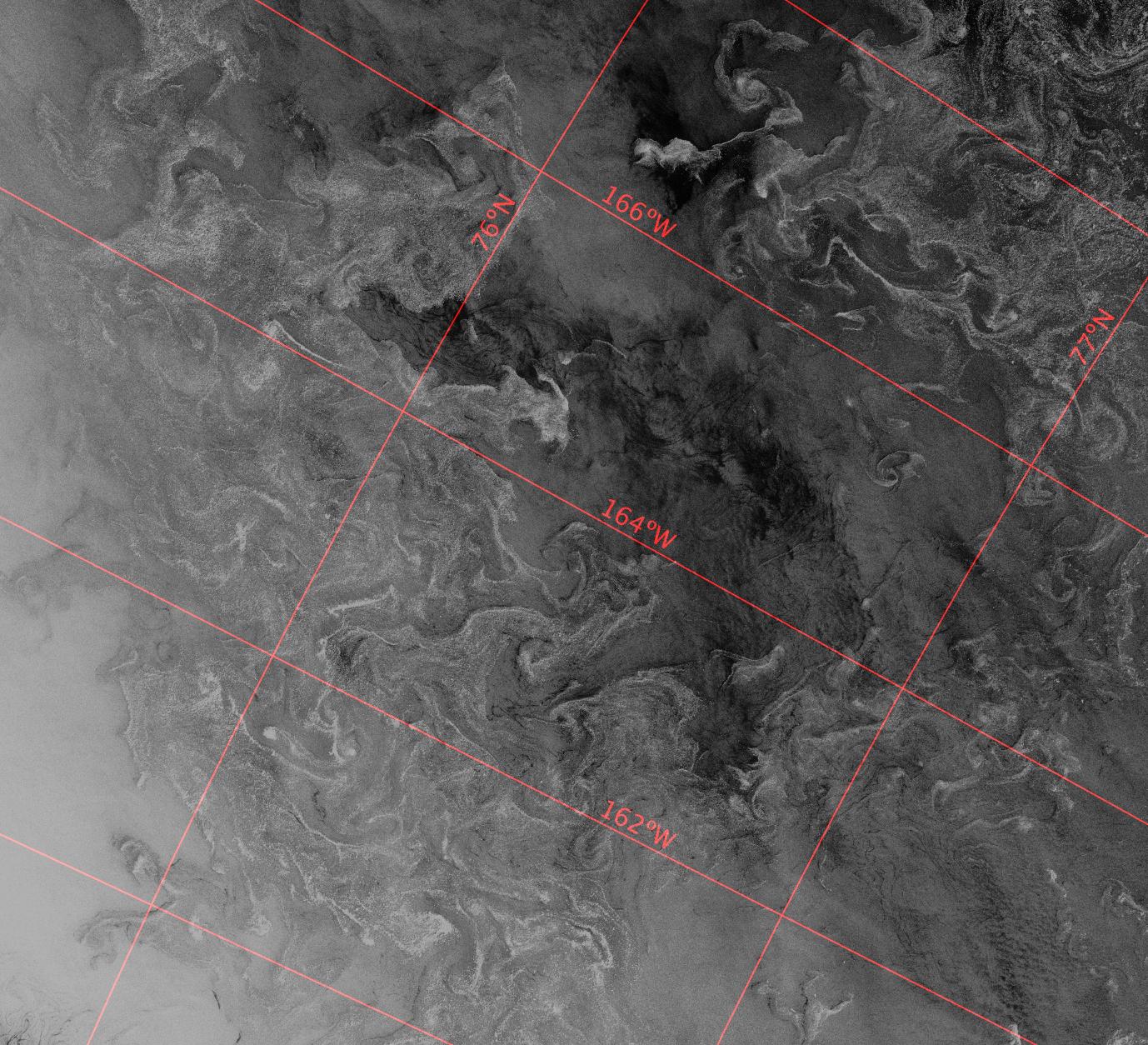
[Edit – August 23rd]
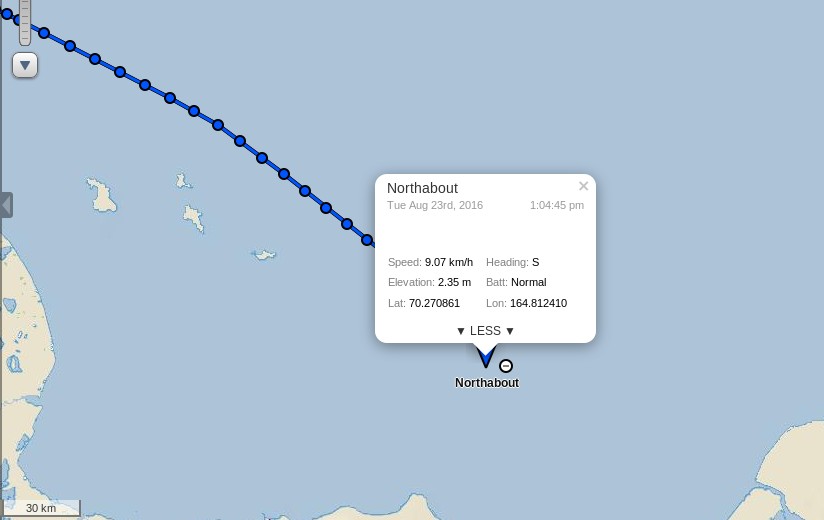
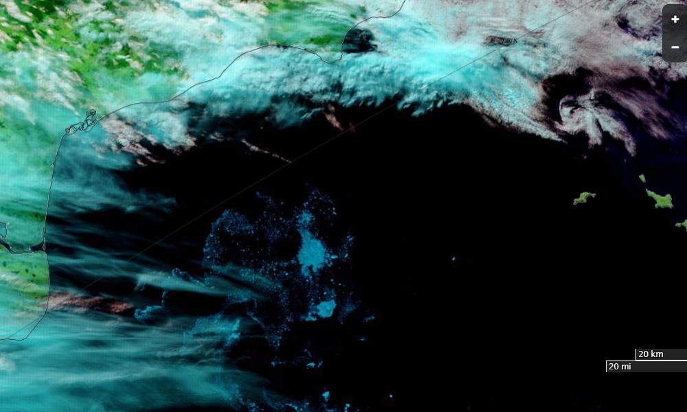
Northabout looks to be turning south:
Presumably that is to skirt the patch of high concentration sea ice in their path, rather than try to break through the lower concentration area to the north (which is towards the bottom of this image!):
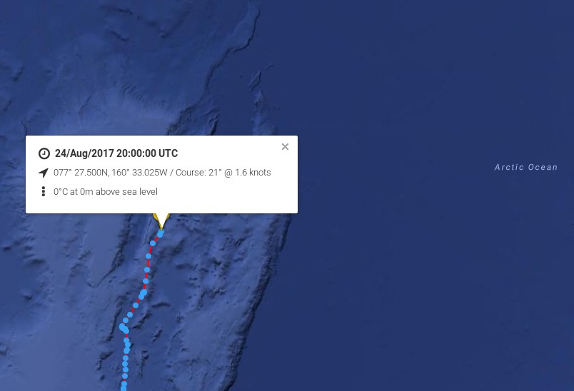
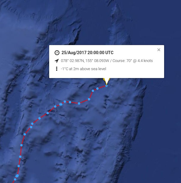
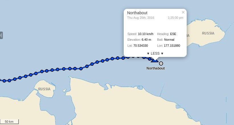
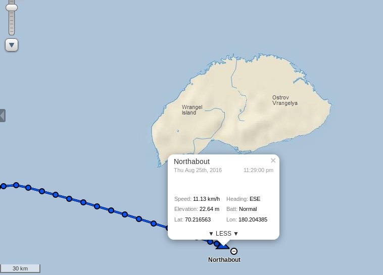
[Edit – August 25th]
Northabout is currently closing in on “the edge of the world” at 180 degrees east and/or west:
Her crew aren’t entirely happy with the speed at which that is happening at present though:
A long slog of a day. Very choppy seas which makes living onboard difficult, especially sleeping, when you can be fast asleep and suddenly wake up in mid air.
The wind we had was a head wind, so slow going. Getting to the edge of the World is proving tiresome.
Our track to get the best wind is towards the ice, and north east, hoping this will change during the night, and bring us back south to our waypoint.
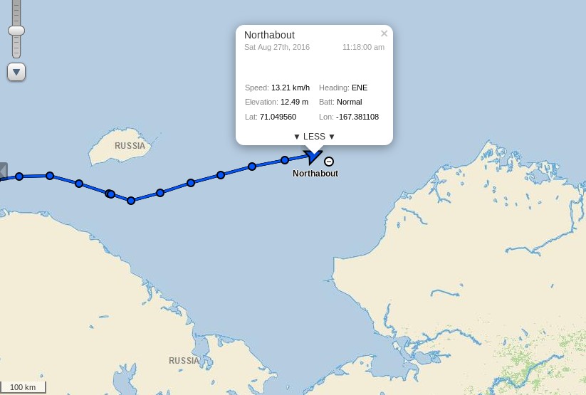
A long slog in the Chukchi Sea. Its renown for its wild weather and seas. With rising winds now in the 25/30 knots, we have had a bumpy ride, but fast and in the right direction.
Well, well, we passed the date line and the W 168 58 .620 at 16.57 boat time, that is the point we can inform the Russian Authorities that we have finished their Northern Sea Route, and we no longer have to report to them daily. I will celebrate this milestone when we get to Point Barrow. It’s only just sinking in what we have all done.
Next stop Barrow, and after that Northabout takes on one of the Southern routes through the NorthWest Passage. It looks like she’ll have much more difficulty spotting some sea ice than on the first half of her polar circumnavigation!
We asked this question last year, albeit a couple of weeks later. It looks like it is if you only peruse passive microwave visualisations such as this one:
However if you were the captain of a yacht attempting to sail through the Northwest Passage this year you might well have some reservations. For example, the Barrow webcam (currently stuck on July 31st) reveals this:
Discretion being the better part of valour, in all the circumstances waiting a day or two longer before casting off might prove prudent:
[Edit – August 3rd]
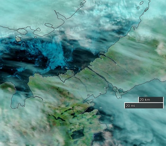
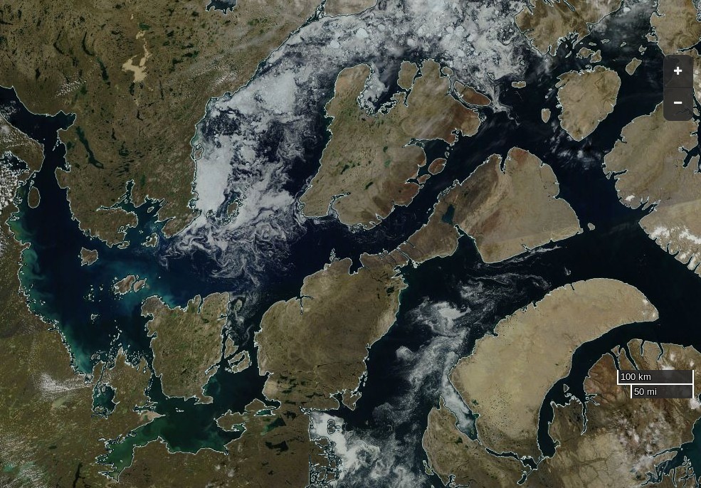
Clearer skies over the Northwest Passage yesterday reveal the remaining ice:
NASA Worldview “true-color” image of Larsen Sound on August 2nd 2016, derived from the MODIS sensor on the Aqua satellite
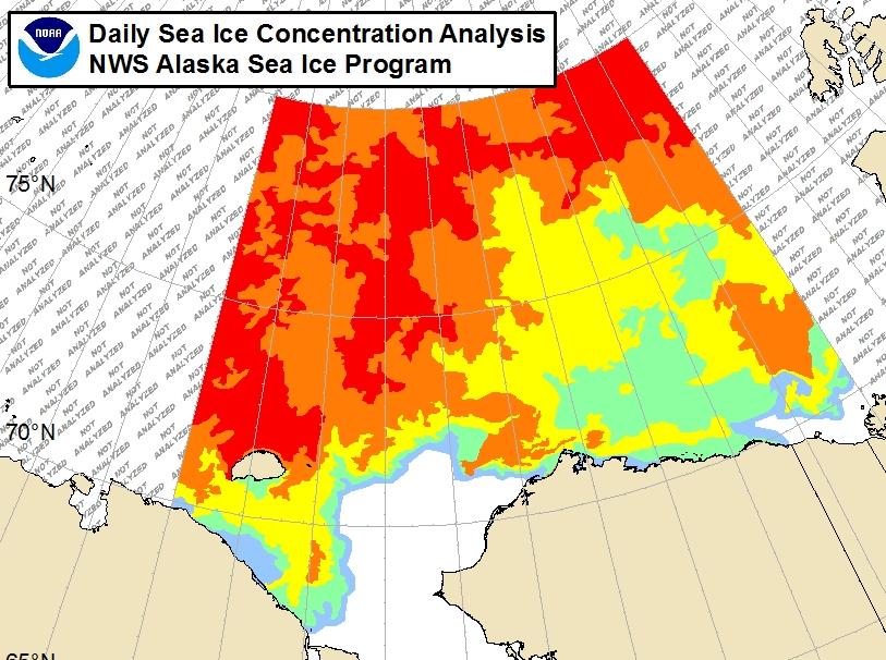
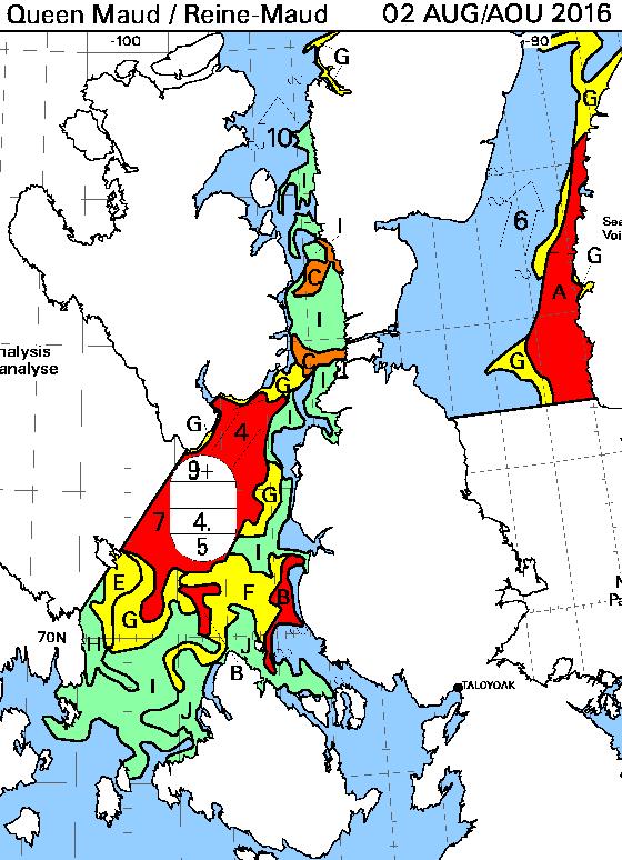
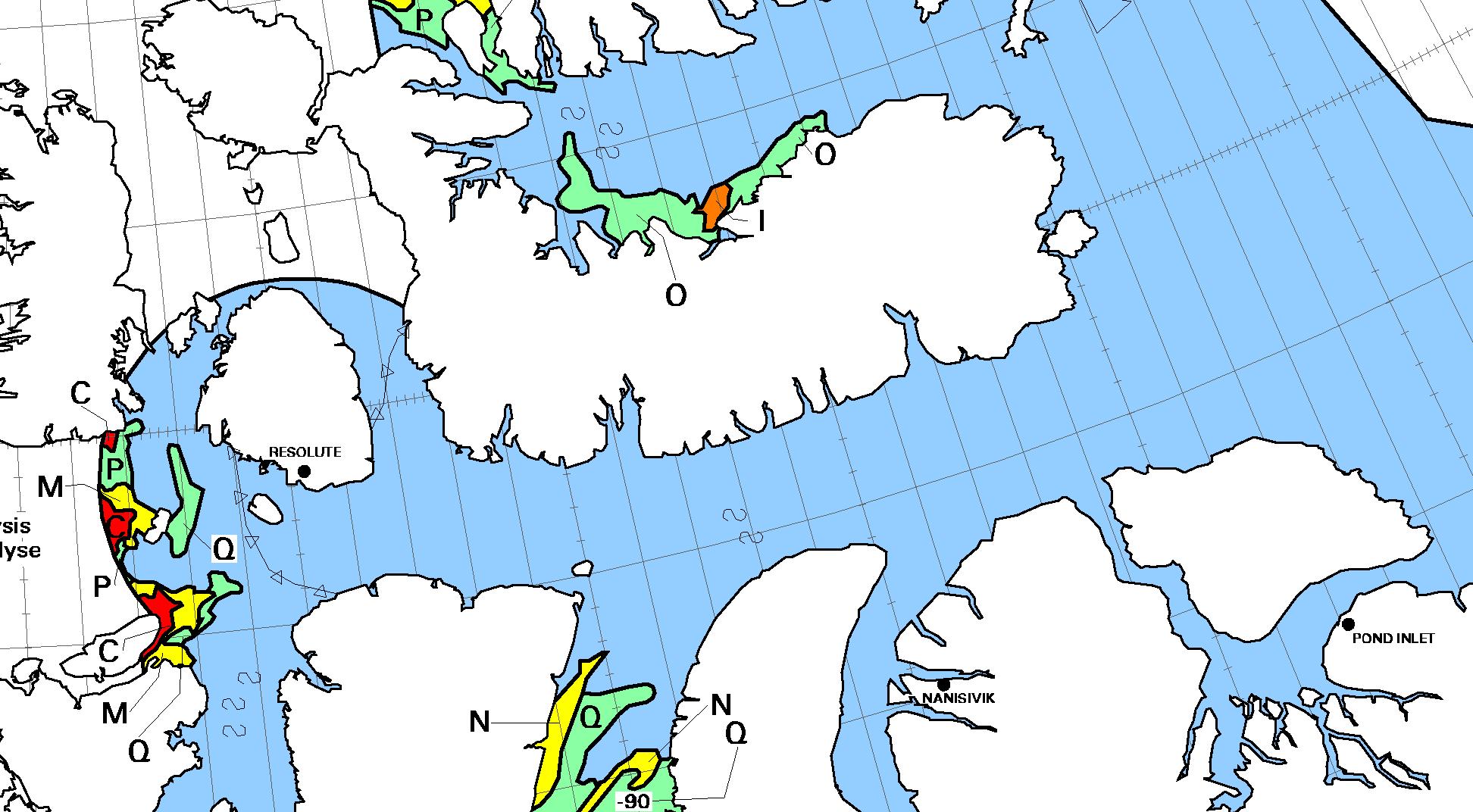
Here’s the CIS chart of the area from yesterday evening:
[Edit – August 7th]
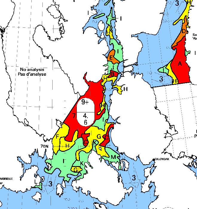
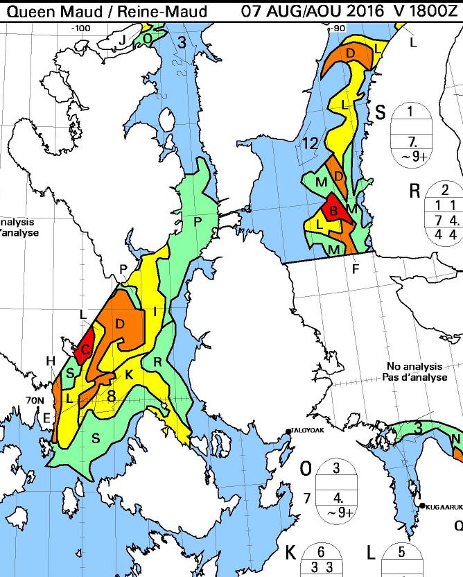
Here’s the August 7th CIS chart for the Queen Maud Gulf and points north:
Today there looks to be a route past Gjoa Havn and through Bellot Strait that doesn’t involve negotiating more than 3/10 concentration sea ice. The ice has been pushed back from Point Barrow too, so by my reckoning we can now declare one route through the Northwest Passage “open”, for the moment at least.
[Edit – August 10th]
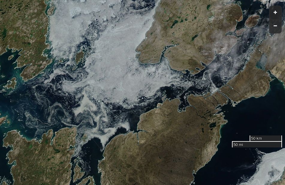
A nice clear MODIS image of the Northwest Passage yesterday:
NASA Worldview “true-color” image of the Northwest Passage on August 9th 2016, derived from the MODIS sensor on the Terra satellite
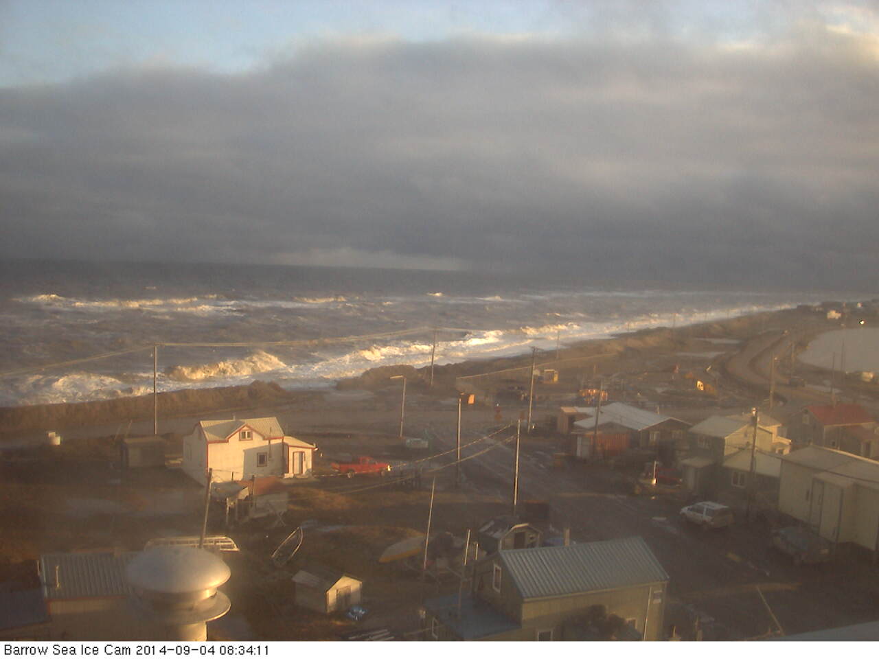
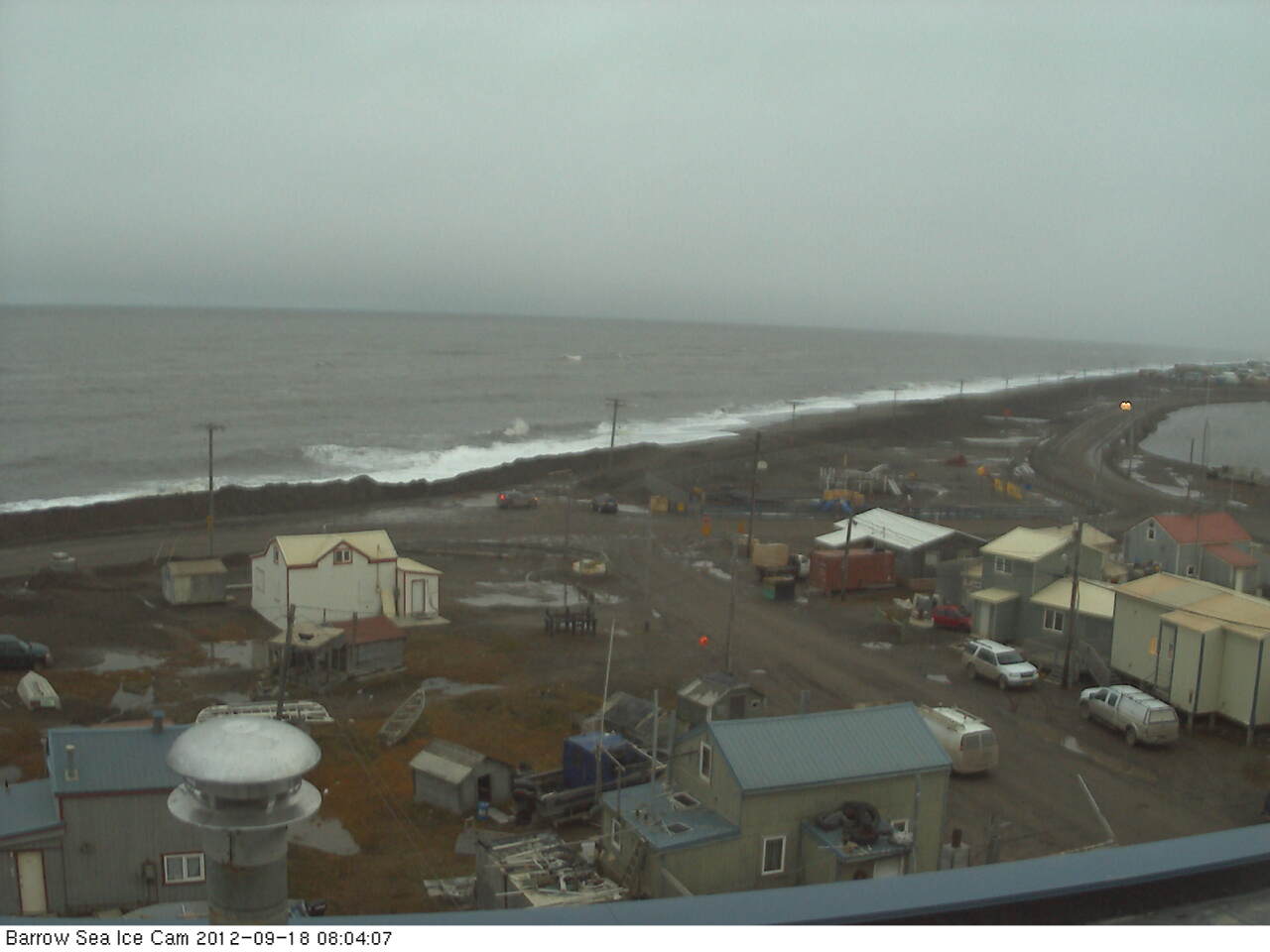
The first big waves of 2015 have been battering the town of Barrow, Alaska today and they’ve already broken through the coastal defences. Firstly take a look at the view from the Barrow webcam during a less damaging storm on September 4th last year:
Now take a look at the view from the same camera earlier today, and play “spot the difference” with me:
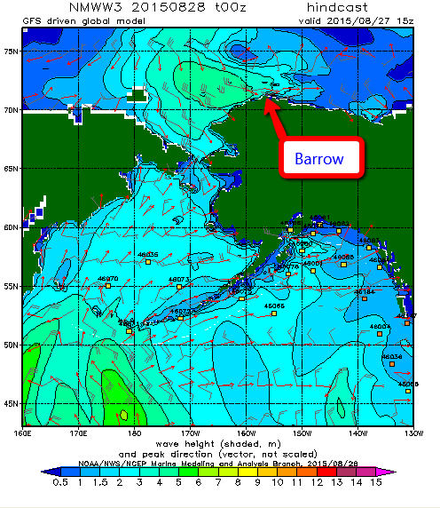
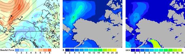
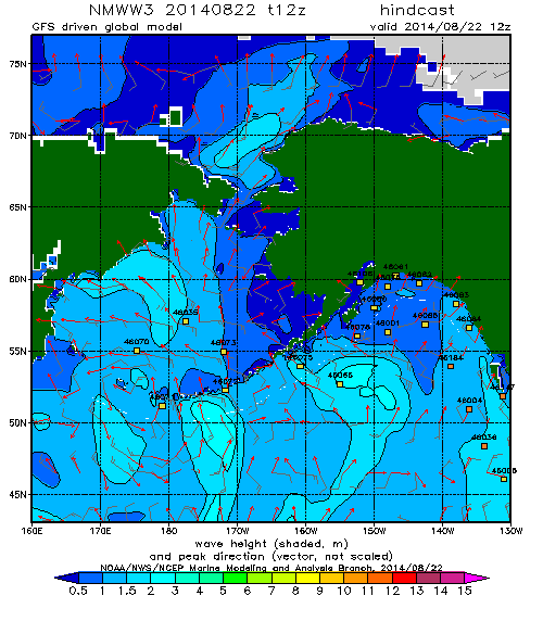
The cause of the flooding that is all too visible is a cyclone that’s been whirling around in the Chukchi Sea for a while, and here is a WaveWatch III “hindcast” of what the resultant winds have created in the way of waves. Firstly the “significant wave height”:
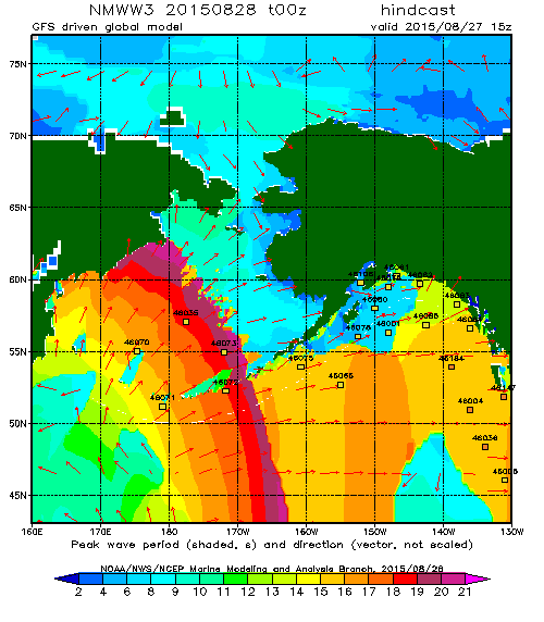
and now the “peak period”:
which reveal a swell 4 to 5 metres high with a period of 10 seconds heading directly towards Barrow Beach. According to the Alaska Dispatch News:
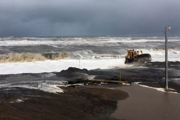
Huge, wind-whipped waves crashed onto the shore at Barrow on Thursday, forcing the closure of a nearby road. Westerly winds were gusting up to 50 miles an hour, pushing waves up to the top of the beach and causing some erosion, the National Weather Service said.
The service has issued a coastal flood warning for Barrow until Friday morning, along with a high surf advisory for the western part of the North Slope and a gale warning for much of the Beaufort and Chukchi Seas.
The big surf and flooding, which has covered a road that runs between the ocean and Barrow’s lagoon, is “not terribly unusual” at this time of the year, said Ryan Metzger, a National Weather Service meteorologist in Fairbanks. Fall is a stormy season, and the timing — right around the annual minimum sea ice extent — allows the surf to build and reach shore.
Photograph by Brittni Driver via Alaska Dispatch News
Just in case it’s not obvious from all the pictures, the respective advisory messages point out that:
A COASTAL FLOOD WARNING MEANS THAT RISING SEA WATER THAT CAUSES FLOODING IS EXPECTED. COASTAL RESIDENTS IN THE WARNED AREA SHOULD BE ALERT FOR RISING WATER…AND TAKE ACTIONS TO PROTECT LIFE AND PROPERTY.
A HIGH SURF ADVISORY MEANS THAT LOCALIZED BEACH EROSION IS EXPECTED. PRECAUTIONS SHOULD BE TAKEN TO PROTECT PROPERTY.
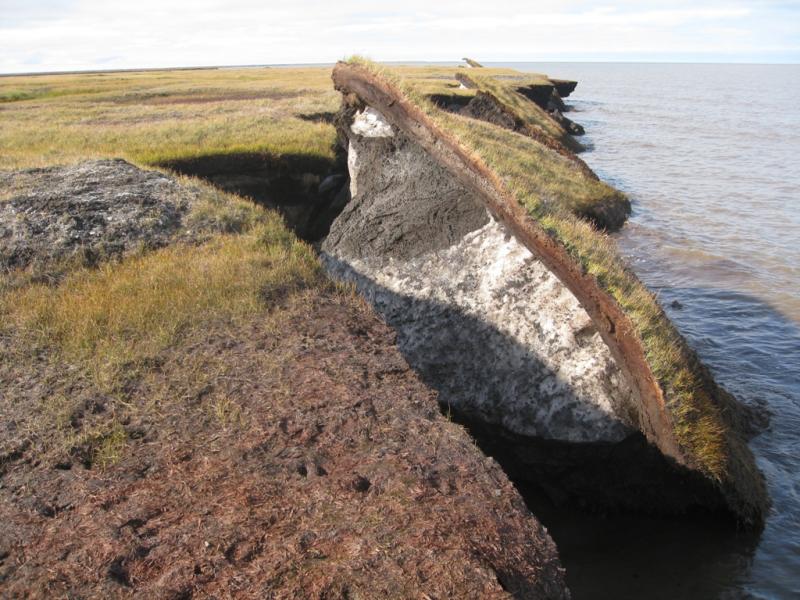
If you’re now wondering what might happen to other areas of the north coast of Alaska in similar circumstances, but with no bulldozer in attendance, here’s an example from Cape Halkett:
Thawing permafrost causes coastline collapse on Alaska’s North Slope, which is no longer kept frozen and protected from fall storms by sea ice—the ice now forms later in the season.
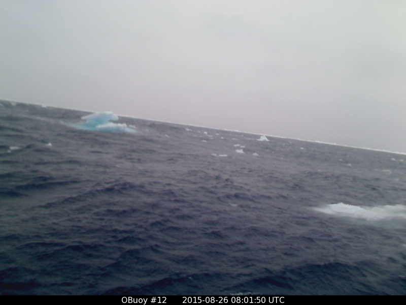
Away from the coast swell from the same cyclone has also been affecting the sea ice north of Barrow, and here’s what a webcam bobbing about on a buoy north of the Chukchi Sea showed as the winds started to build yesterday:
O-Buoy 12 image from August 26th 2015
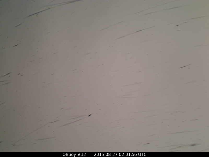
O-Buoy 12 has now tipped over and then ceased transmitting. This is the last picture received, in the early hours of August 27th when the wind speed had reached 13 m/s and the buoy had been moving at over 5 m/s:
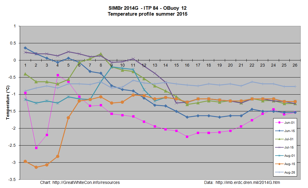
Once upon a time O-Buoy 12 was sat on the same ice floe as ice mass balance buoy 2014G, which has also been free floating for a while. Here’s what it reveals about the temperature of the sea water on August 26th 2015 at 77.56 N, 163.86 W:
Somewhere in the vicinity of -0.7 °C.
[Edit on 30/08/2015]
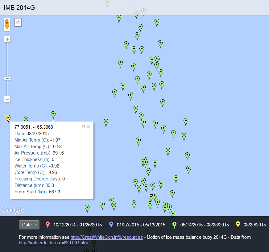
O-Buoy 12 has made no further transmissions, and therefore seems to have succumbed to the storm. In addition IMB buoys 2014F and 2013F stopped transmitting on the 26th and 27th of August respectively. Ice mass balance buoy 2014G has survived however, and reports two successive record daily distances travelled:
25.6 km on August 26th, followed by 36.3 km on the 27th. After a brief dip during the cyclone water temperature is still around -0.7 °C.
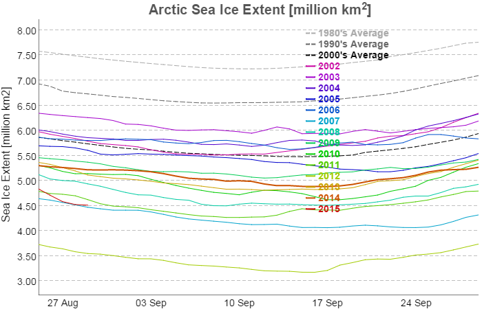
Presumably as a result of the cyclone JAXA Arctic sea ice extent has taken a tumble over the last few days. It has stabilised this morning slightly above 2007 levels:
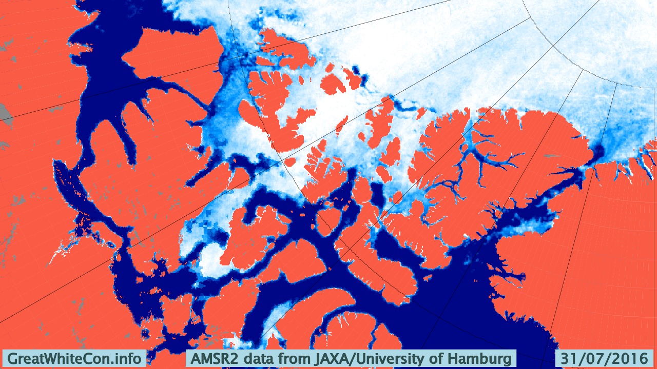
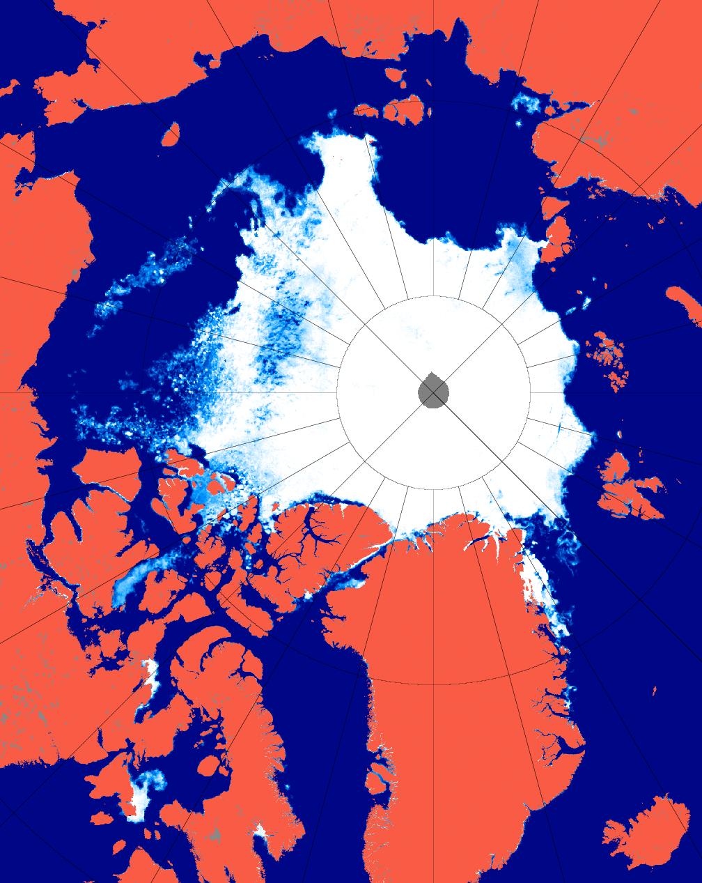
Here is the current AMSR2 Arctic sea ice concentration map from the University of Hamburg, revealing a large potential fetch across the East Siberian, Chukchi and Beaufort Seas should any further cyclones occur in the area over the next few weeks:
AMSR2 Arctic sea ice concentration on August 29th from the University of Hamburg
Hence the conditions now exist for an even more damaging swell to be generated before the 2015 minimum Arctic sea ice extent is reached.
Today we’re going to delve into the application of surf science in the Arctic. If you’re not already familiar with the basics of how the best surf is created then perhaps you might first wish to take a detour to the StormSurf “Wave Basics” article:
Wind waves, though rideable, are not the optimal type of wave one likes to ride. Swells are much better. Wind waves are only the raw material that swells are made from. But, the more energy wind waves accumulate while being driven by wind, the greater the likelihood they will transform into a swell. Enough energy and the swell can travel the entire circumference of the globe with only a slow decay in size!
During a typical open ocean winter storm, one could expect to see winds of 45-55 kts blowing over 600-1000 nautical miles for 36 hours. In such a storm, the average highest wind waves (or ‘seas’) commonly reach 30-35 ft towards the center of the fetch area and produce a swell with a period of 17-20 secs.
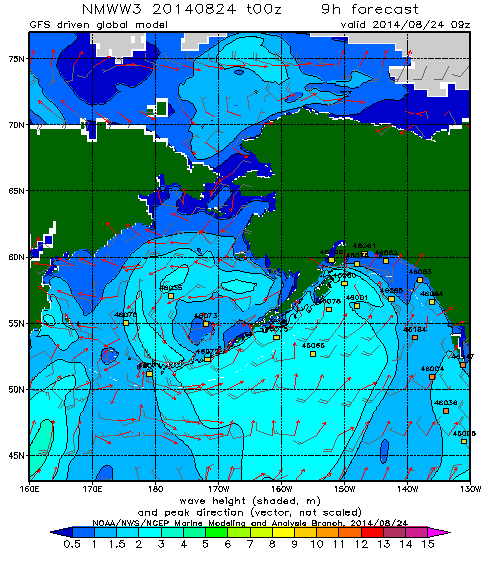
Regular readers may recall that on August 24th 2014 we revealed this WaveWatch III “surf forecast” for the Beaufort Sea, which lies off the north coast of Alaska and the Canadian Northwest Territories (i.e. top center of the map): and noted that the 2 meter waves depicted:
Have blasted past Point Barrow and are currently heading straight for the Beaufort Sea Marginal Ice Zone.
Here’s a video from the University of Washington’s Applied Physics Laboratory which explains that the Marginal Ice Zone is:
The area between declining unbroken sea ice and the expanding area of open water.
The theoretical significance of such swells has been discussed in a number of academic papers recently. Take for example these extracts from “Swell and sea in the emerging Arctic Ocean” by Jim Thomson from the University of Washington and W. Erick Rogers from the US Naval Research Laboratory. Note first of all that the authors distinguish between “wind seas” and “swells” as follows:
Pure wind seas have a wave age less than one, indicating that the wind is driving the waves, and these points cluster largely below the Pierson–Moskowitz limit. Swells have a wave age greater than one, indicating that the waves are outrunning the wind.
They then go on to use some more terms very familiar to the average surfer:
Ocean surface waves (sea and swell) are generated by winds blowing over a distance (fetch) for a duration of time. In the Arctic Ocean, fetch varies seasonally from essentially zero in winter to hundreds of kilometers in recent summers. Using in situ observations of waves in the central Beaufort Sea, combined with a numerical wave model and satellite sea ice observations, we show that wave energy scales with fetch throughout the seasonal ice cycle. Furthermore, we show that the increased open water of 2012 allowed waves to develop beyond pure wind seas and evolve into swells. The swells remain tied to the available fetch, however, because fetch is a proxy for the basin size in which the wave evolution occurs. Thus, both sea and swell depend on the open water fetch in the Arctic, because the swell is regionally driven. This suggests that further reductions in seasonal ice cover in the future will result in larger waves, which in turn provide a mechanism to break up sea ice and accelerate ice retreat.
It is possible that the increased wave activity will be the feedback mechanism which drives the Arctic system toward an ice-free summer. This would be a remarkable departure from historical conditions in the Arctic, with potentially wide-ranging implications for the air-water-ice system and the humans attempting to operate there.
In practice there were several more swells that impacted the Beaufort Sea marginal ice zone over the course of the next couple of weeks. Here’s what the charts looked like, as visualised by MagicSeaweed.com rather than NOAA:
Beaufort Sea on August 27th 2014 – Winds / Wave Height / Wave Period
Beaufort Sea on September 1st 2014 – Winds / Wave Height / Wave Period
Beaufort Sea on September 7th 2014 – Winds / Wave Height / Wave Period
Note that on the right of each set of three is a depiction of the period of the waves in question. As StormSurf points out:
Chop tends to have a period ranging from 3-8 seconds. That is, there is anywhere from 3-8 seconds between each wave crest. Wind waves range from 9-12 seconds. Ground swells range from 13-15 seconds, and strong ground swells have a period anywhere from 16-25 or more seconds.
Thus the final swell on September 7th was actually the best of the bunch, with a small area of waves over 10 feet in height and with a period of over 9 seconds. According to StormSurf those are merely “wind waves” and not yet a full blown “swell”. To give you a feel for such waves here’s what some “wind waves” hitting the beach at Barrow looked like on September 4th 2014:
Next here’s another video that reveals what effect those series of waves had on the sea ice in the Beaufort Sea:
For future reference here also is the same swell described by Thomson and Rogers, but illustrated in an identical “surfer friendly” format to the 2014 swells we’ve been looking at:
Beaufort Sea on September 18th 2012 – Winds / Wave Height / Wave Period
whilst here is the swell produced by the “Great Arctic Cyclone” of early August 2012, also mentioned in passing by Thomson and Rogers:
Beaufort Sea on August 5th 2012 – Winds / Wave Height / Wave Period
As you can see, if you’re a surfer used to tracking swells across the world’s oceans at least, whilst the September 2012 swell was indeed rather more substantial than those we have looked at in 2014, with a height in excess of 20 feet, the period was too short to qualify as a full blown swell and it was in fact directed away from the ice edge rather than towards it. Here’s what that 2012 swell looked like once it reached Barrow:
All of which does rather make one wonder what might happen if a slightly longer period swell directed at the ice edge in the Beaufort Sea were to occur at some point in the not too distant future? Whilst we all wait with bated breath to discover what that future holds for the sea ice in the Arctic, not to mention the beach at Barrow, here’s another video about the 2014 Marginal Ice Zone Program, which summarises the year’s campaign as a whole:
Note that Craig Lee says that:
We had very little wave activity. It was surprisingly calm when we were out there in the Araon, both when we were in the ice and in the open water. There just wasn’t much wind, and so there weren’t very many surface waves.
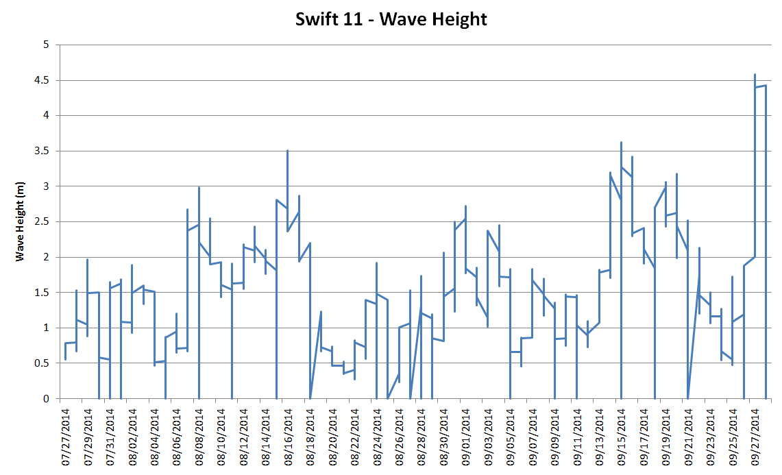
However at least one of the “robots” he refers to did discover some significant wave activity. Here’s a visualisation of SWIFT 11‘s record of significant wave height as it floated across the Beaufort Sea in the summer of 2014:
I don’t know about you, but I don’t think I would describe 4.5 meter waves as “surprisingly calm”, especially in the Arctic!
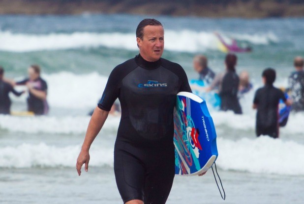
Shock News! It has recently been brought to our attention by the online version of the Western Morning News (WMN for short), our local daily newspaper, that the once Great Britain’s current Prime Minister (GBPM for short) has been secretly training for next week’s Arctic Basin big wave surfing contest just down the road from here in North Cornwall! According to the WMN:
David Cameron let criticism of his Cornish holiday wash over him today as he hit the waves. Today he spent the afternoon riding the waves on the beach at Polzeath, surrounded by ordinary holidaymakers. Mr Cameron took to the water in a three quarter-length wet suit and brightly-coloured bodyboard. He was accompanied by a detective who kept a discreet watch on him from the shallows.
Despite the discreet detective an intrepid paparazzo braved the pounding Polzeath surf and managed to grab this shot of Mr. Cameron in action:
The next obvious question, to us here in the Great White Con Ivory Towers at least, is whether Dave would prefer to wear neoprene or fur for the competition next week. Which do you think suits him best?
In the meantime the surf on Barrow beach is building:
and even as we speak a pulse of swell has blasted past Point Barrow and is currently heading straight for the Beaufort Sea Marginal Ice Zone.
Shock News! Over in the denialosphere at the (un)Real Science blog I’ve been challenged to yet another Arctic sea ice bet. This one now seems to be signed and sealed, but will probably have to wait a few years before it is delivered:
Them:
Have you come up with the terms of our bet yet? I have yet to find one single alarmist willing to bet their house on an ice free Arctic at any time over the next 20 years, I may have to extend to 30 years, though the amount of cigarettes I smoke, I doubt I will be around that long.
Us:
Having personally discussed the matter with Rear Admiral Jon White:
and having since publicly stated that I’m more pessimistic than him, how about $1000 in favour of ShelterBox on CT area < 1 mio square kilometers by the summer of 2022 at the latest?
Them:
$1000 on CT area being less than 1 million square kilometres at some point between now and 2022 sounds fine to me, we have a bet. Remember, this is where to send your $1000
Meanwhile I’ve been trying to find someone, anyone, willing to don a polar bear suit and then stand up on a surf board. I have yet to find one single “skeptic” willing to accept my challenge to become part of the “Great Green Con” Arctic surf team. First in line for an invitation was “Steve Goddard” (AKA Tony Heller):
Them:
Within a week, a cyclone will be spreading Arctic sea ice, and extent will flat line or increase.
Us:
I’m following that cyclone with much interest too Tony! What’s your Arctic surf forecast?
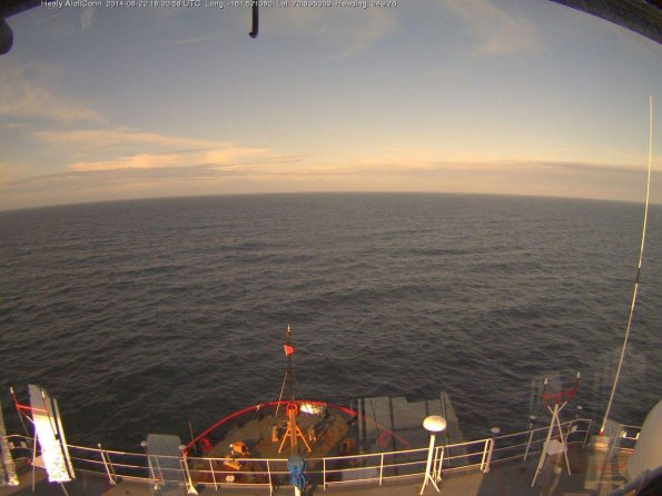
Whilst we wait for a “skeptic” willing to stop doing a chicken impression and start impersonating a polar bear to reveal themself, how is the surf in the Chukchi Sea coming along? There are already some signs of a building swell to be seen. The US icebreaker USCGC Healy is currently bobbing about on a modest swell off Barrow:
Whilst onshore a modest wave can currently be seen breaking on Barrow beach:
Here’s what that swell looks like on the WaveWatch III nowcast:
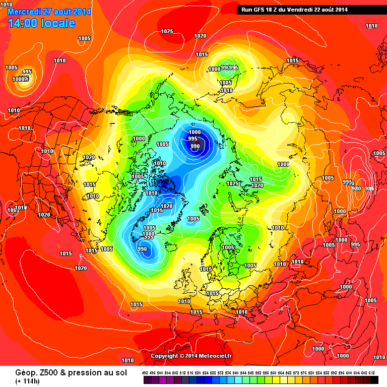
Meanwhile the cyclone brewing in the Arctic is now forecast to have a central pressure below 990 mb next week, by GFS at least:
We’ll keep you posted!
This website uses cookies to improve your experience. We'll assume you're ok with this, but you can opt-out if you wish. Cookie settingsACCEPT
Privacy & Cookies Policy
Privacy Overview
This website uses cookies to improve your experience while you navigate through the website. Out of these, the cookies that are categorized as necessary are stored on your browser as they are essential for the working of basic functionalities of the website. We also use third-party cookies that help us analyze and understand how you use this website. These cookies will be stored in your browser only with your consent. You also have the option to opt-out of these cookies. But opting out of some of these cookies may affect your browsing experience.
Necessary cookies are absolutely essential for the website to function properly. This category only includes cookies that ensures basic functionalities and security features of the website. These cookies do not store any personal information.
Any cookies that may not be particularly necessary for the website to function and is used specifically to collect user personal data via analytics, ads, other embedded contents are termed as non-necessary cookies. It is mandatory to procure user consent prior to running these cookies on your website.