Tag Archives: Waves

The 2017 Arctic Sea Ice Metric Minima

September has arrived once again, the month in which the assorted Arctic area and extent metrics (almost) always reach their respective annual minima. Now we can start to speculate about what the assorted minima will be, and on what date.

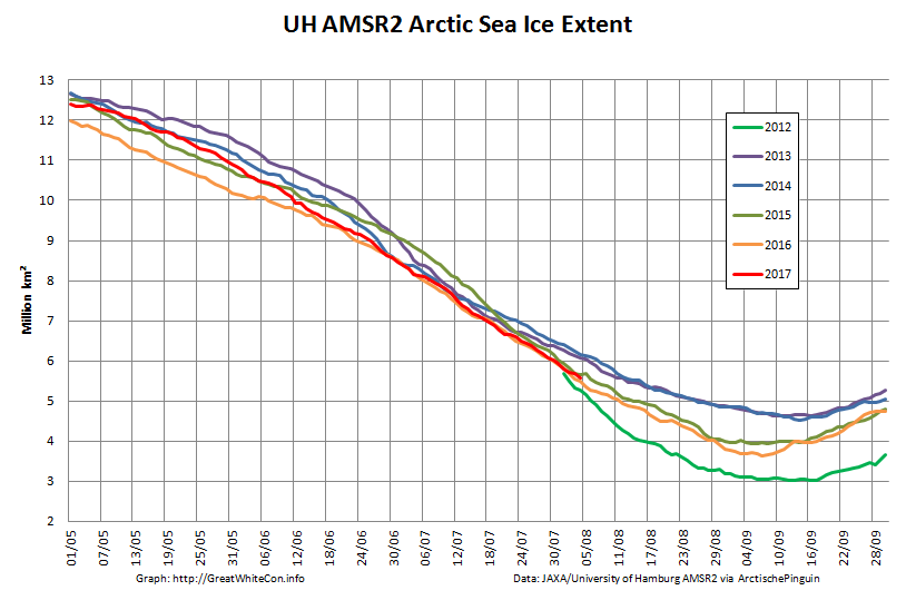
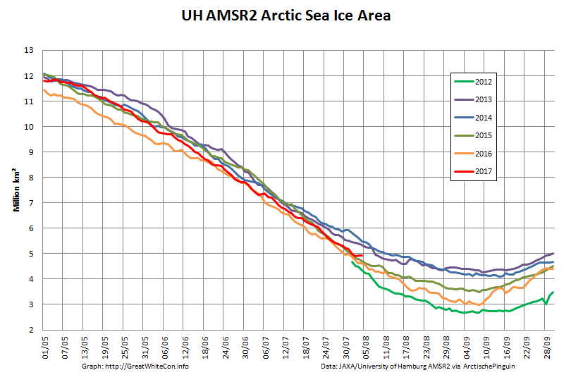
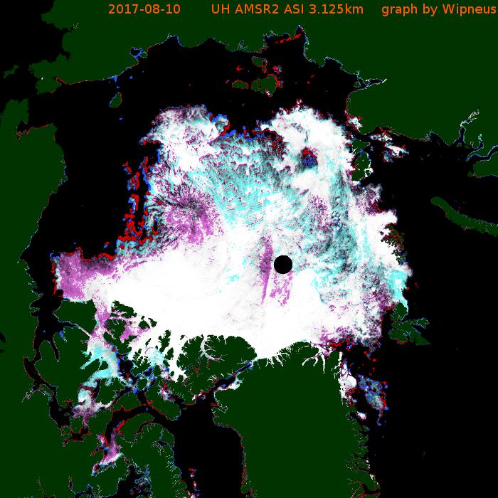
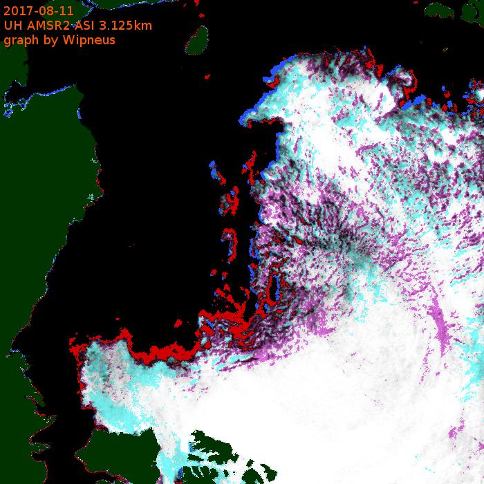
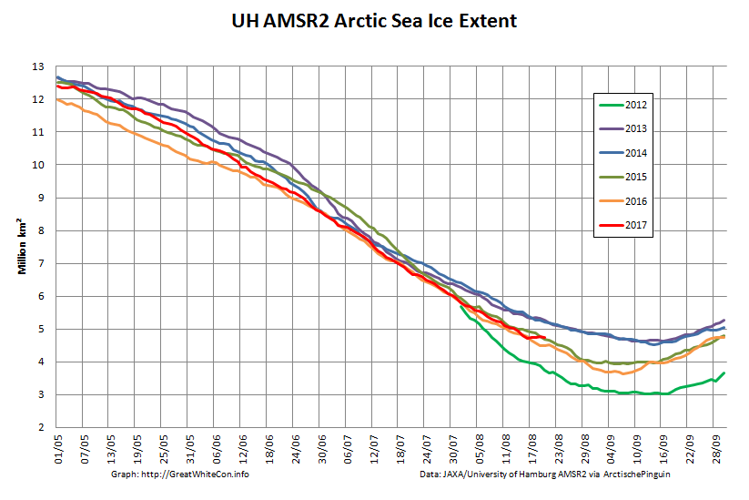
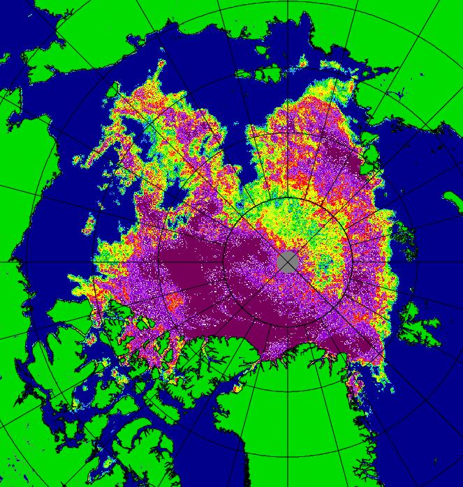
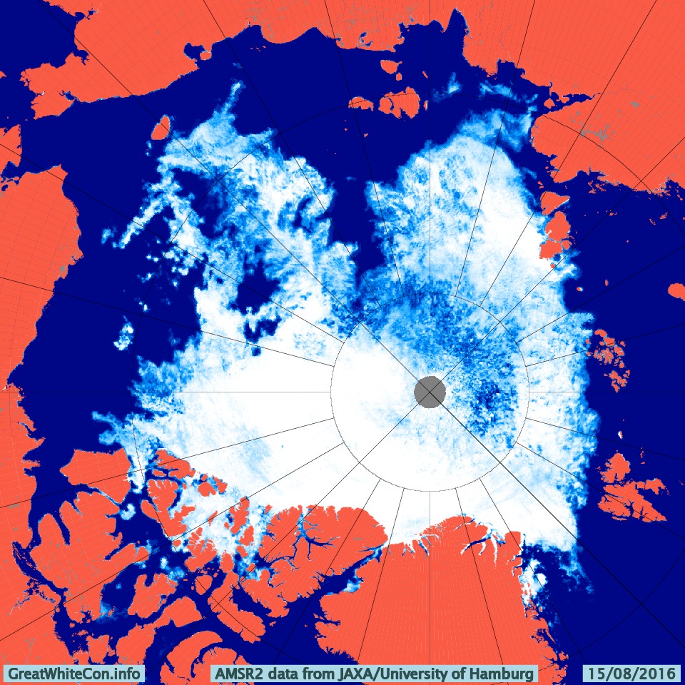
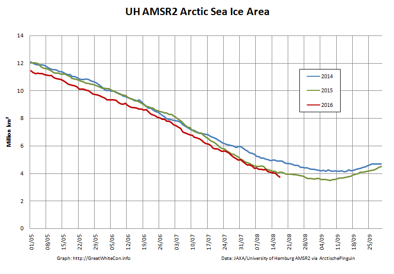
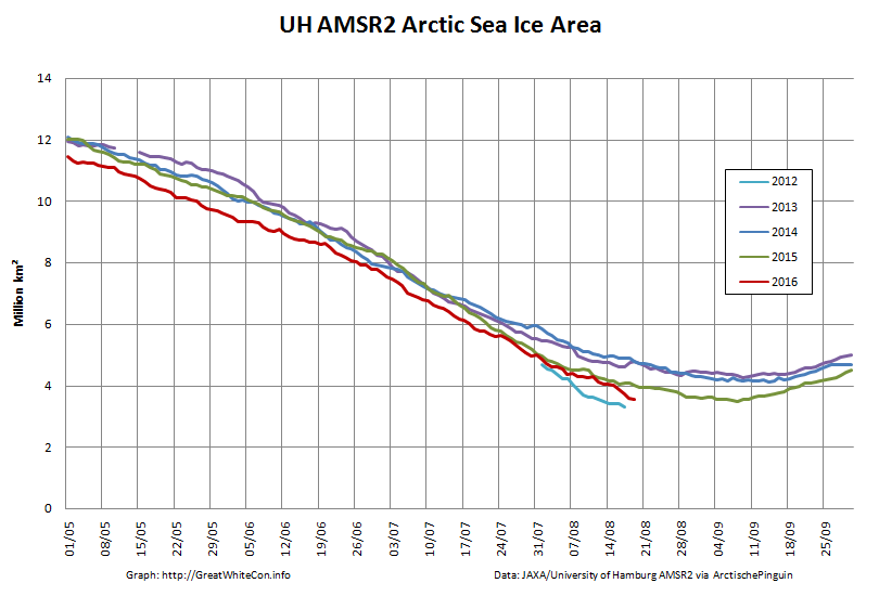
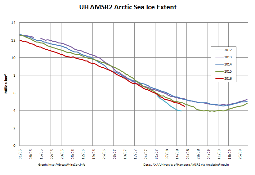
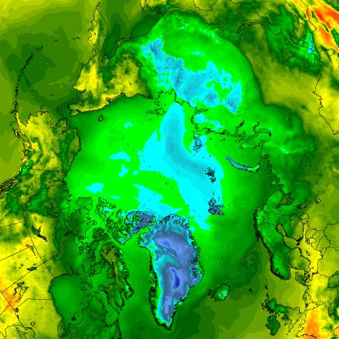
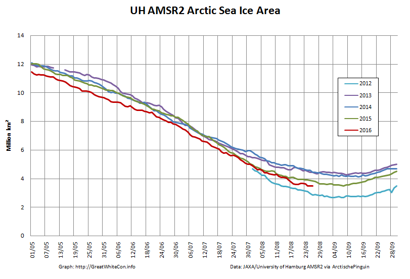
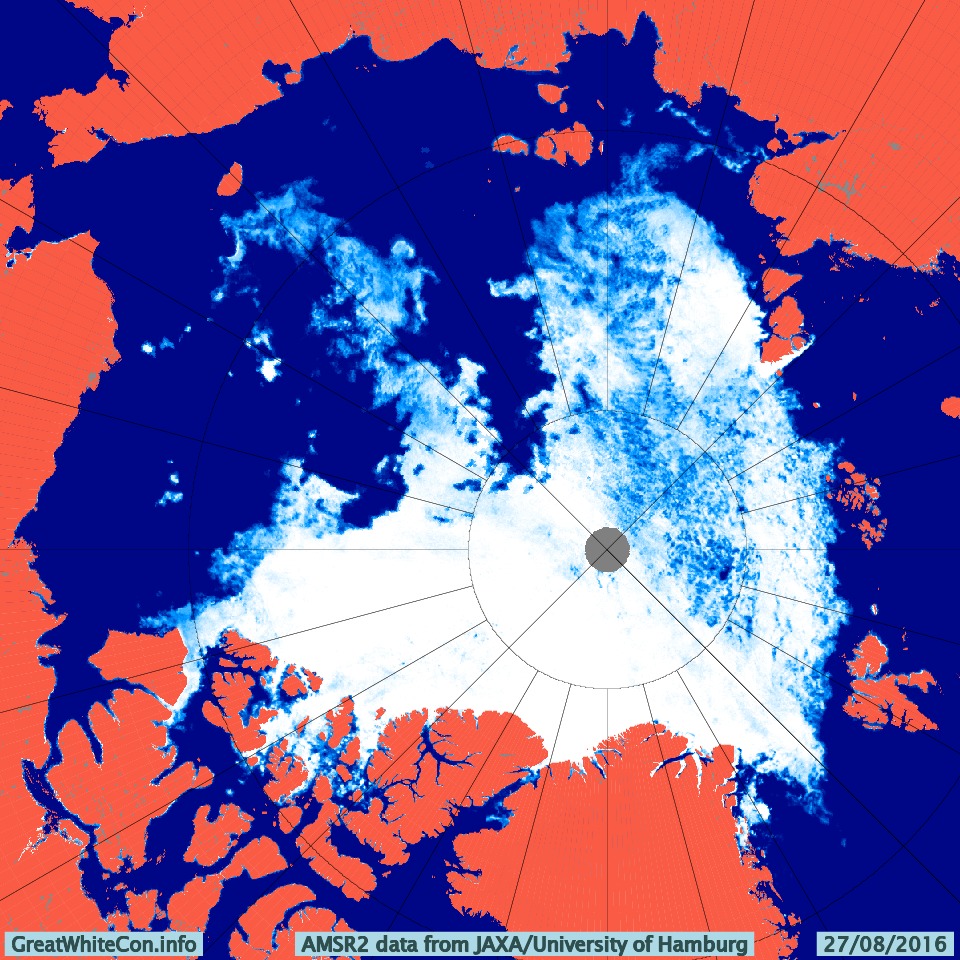
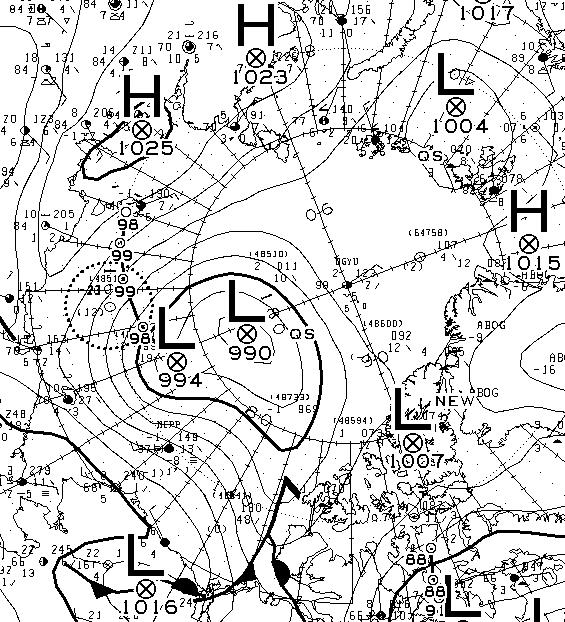
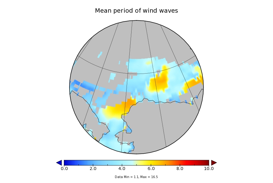
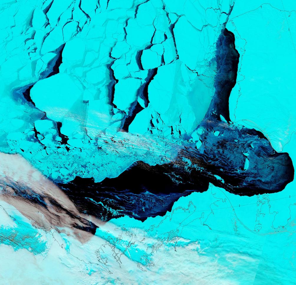
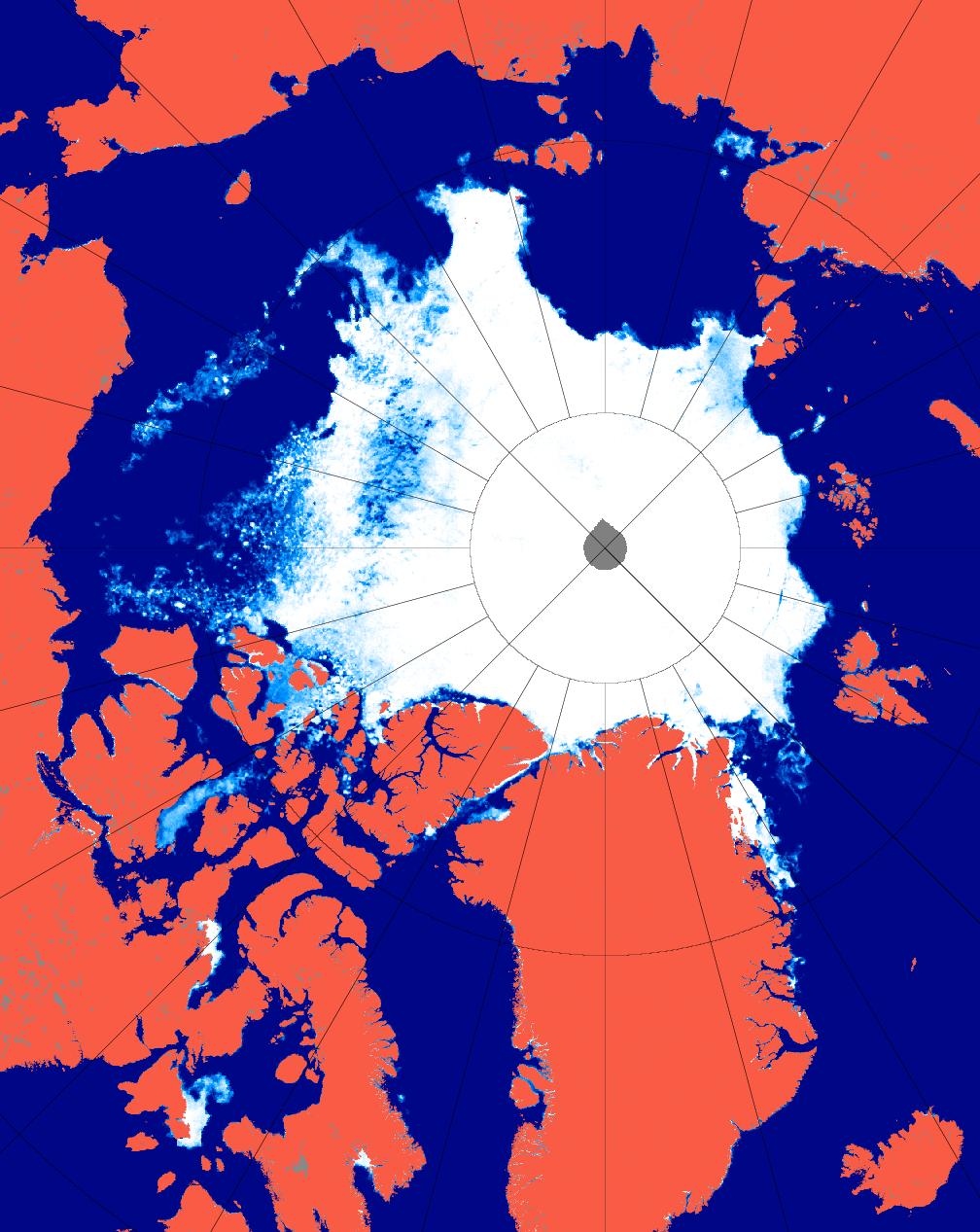
First of all let’s take a look at “Snow White’s” favourite high resolution AMSR2 metrics derived by “Wipneus” from University of Hamburg AMSR2 concentration data:

UH-Arctic-Area-2017-09-02

UH-Arctic-Extent-2017-09-02

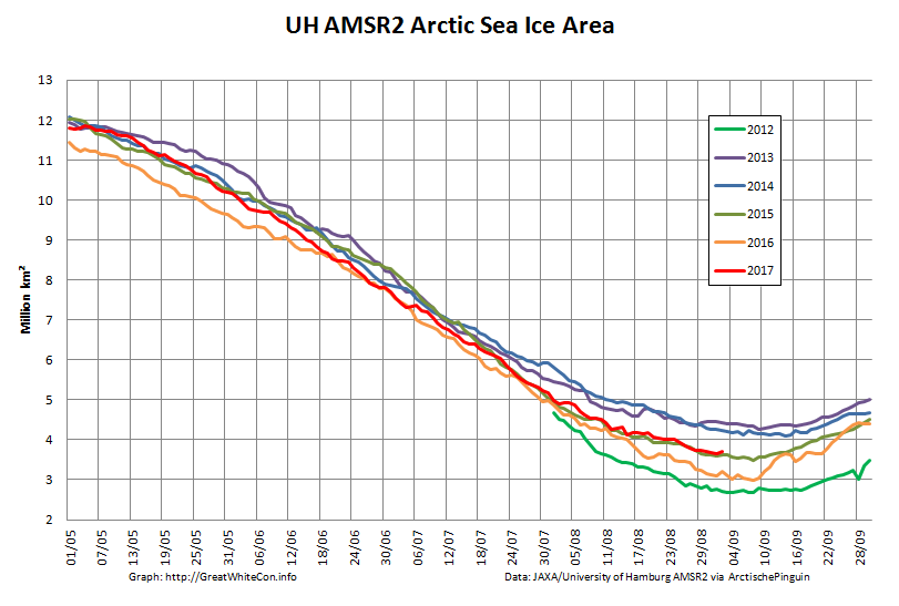
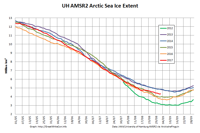
As you can see, today’s values are both higher than yesterday’s. Hence we already have potential minima to consider! In this case:

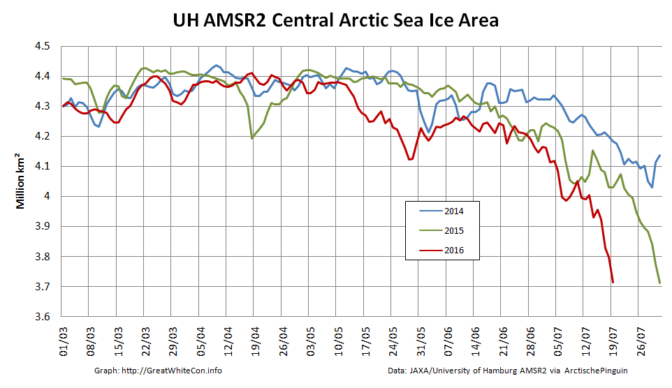
UH AMSR2 Area – 3.65 million km² on September 1st
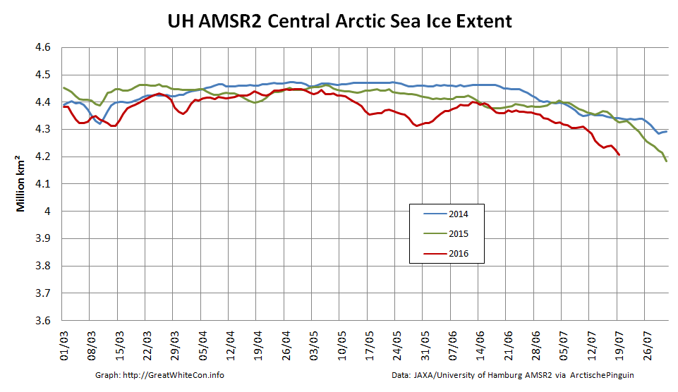
UH AMSR2 Extent – 4.30 million km² on September 1st

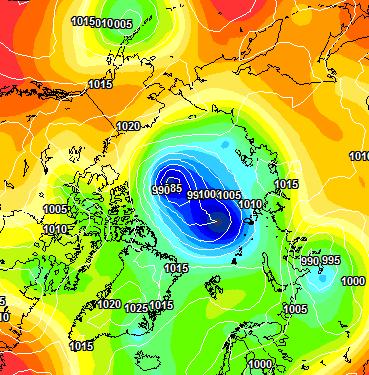
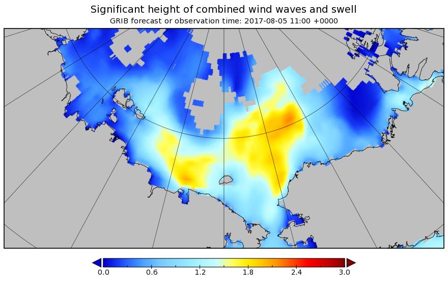
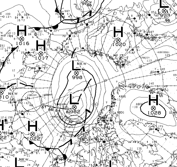
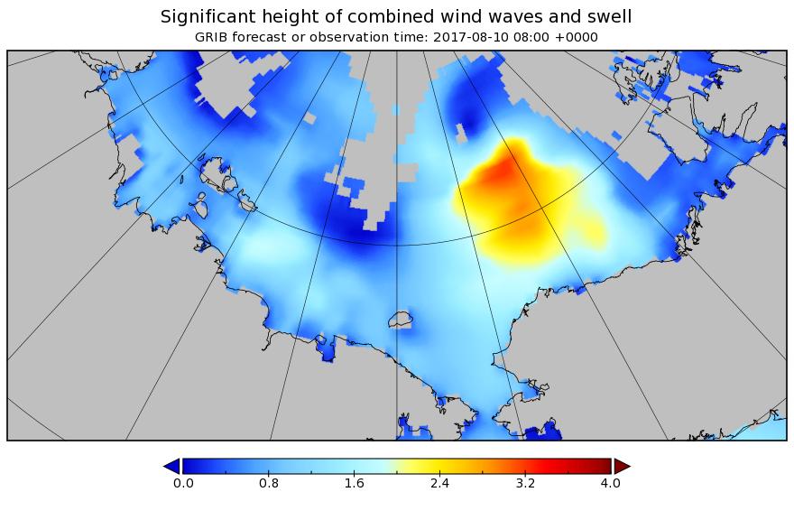
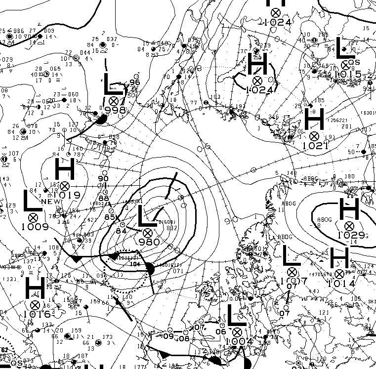
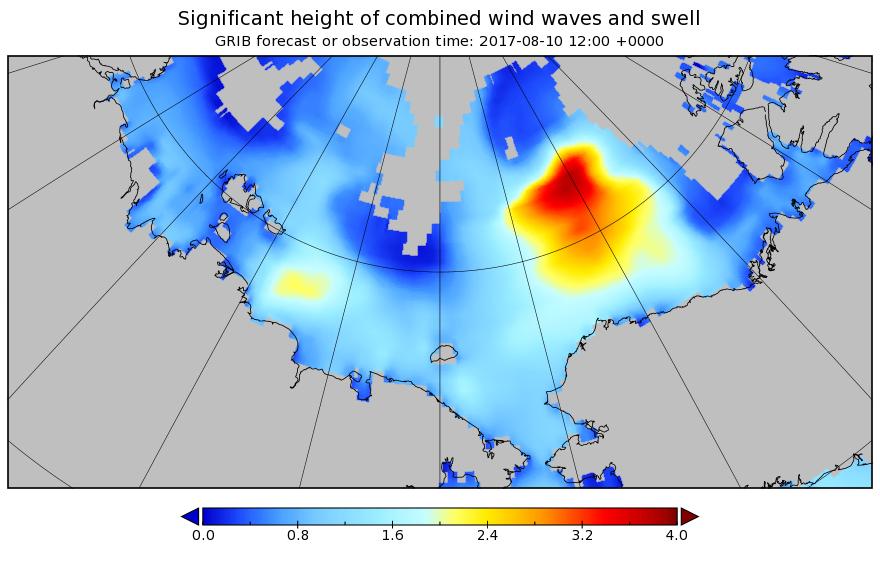
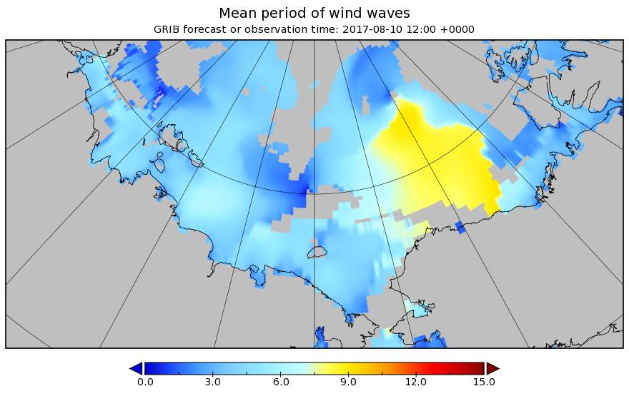
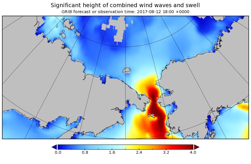
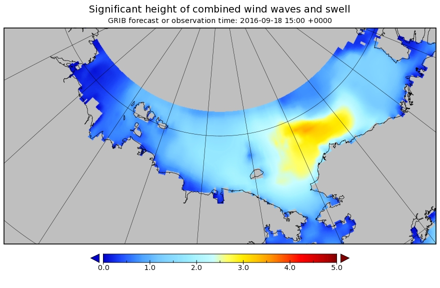
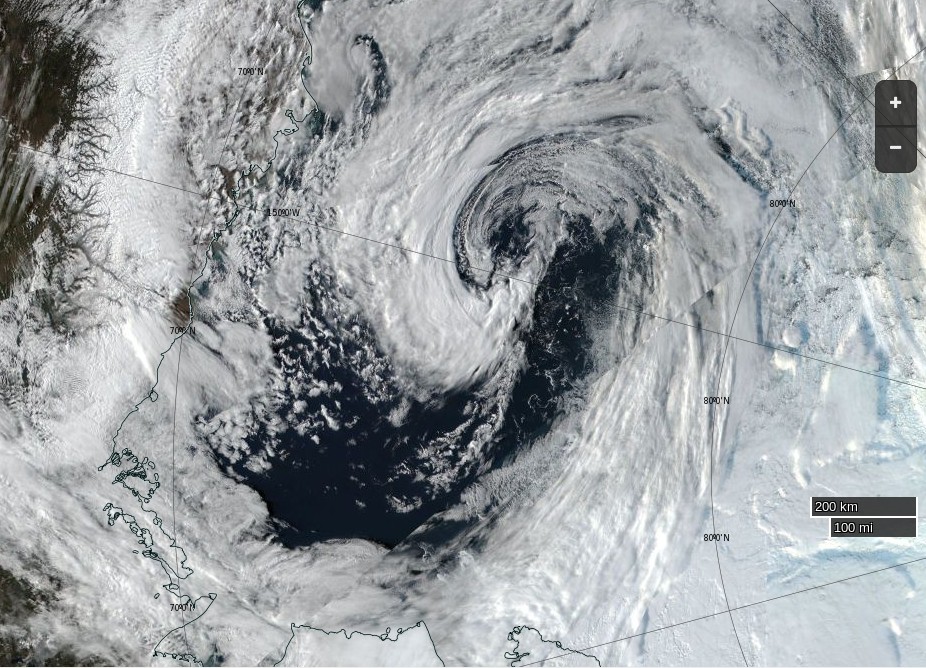
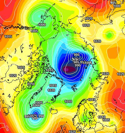
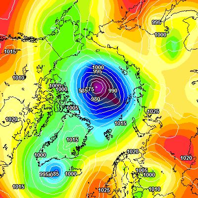
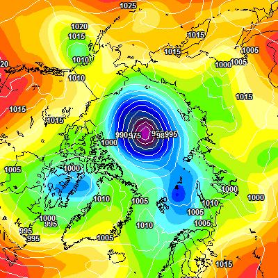
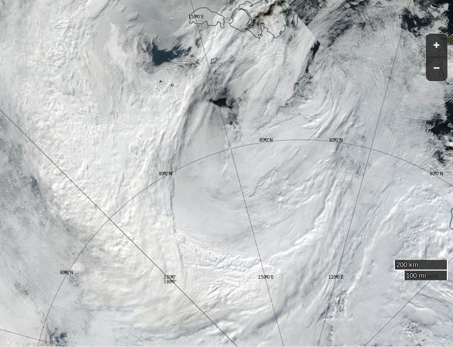
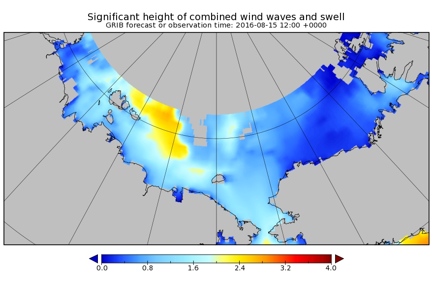
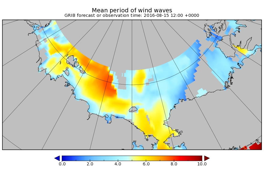
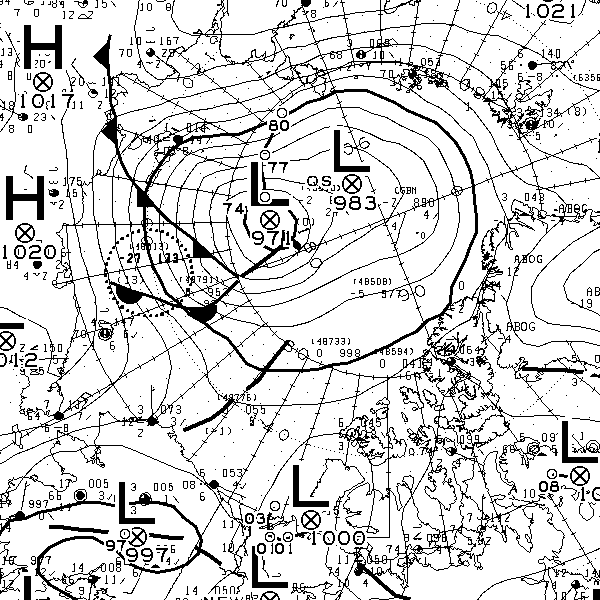
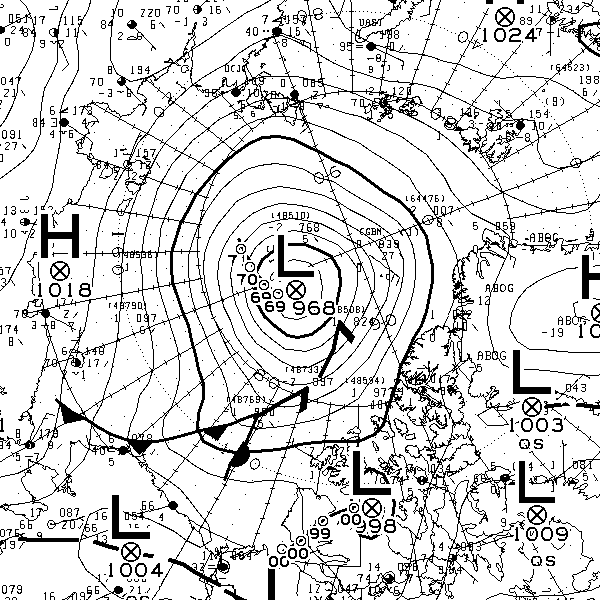
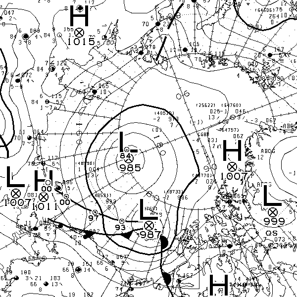
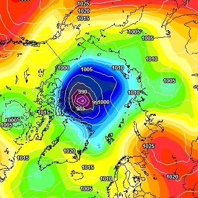
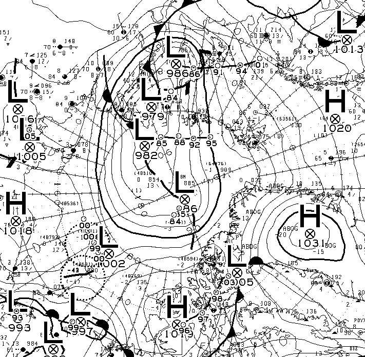
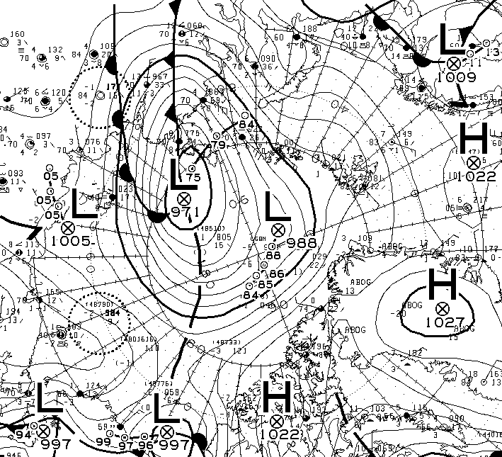
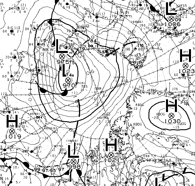
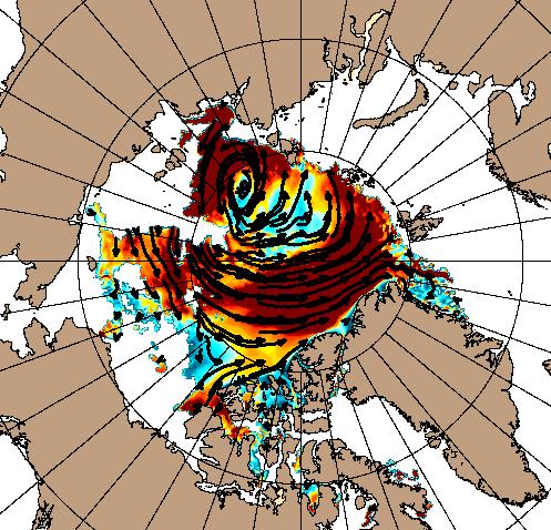
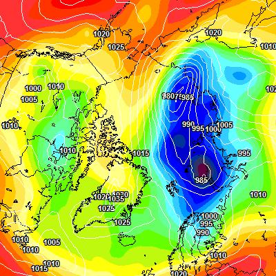
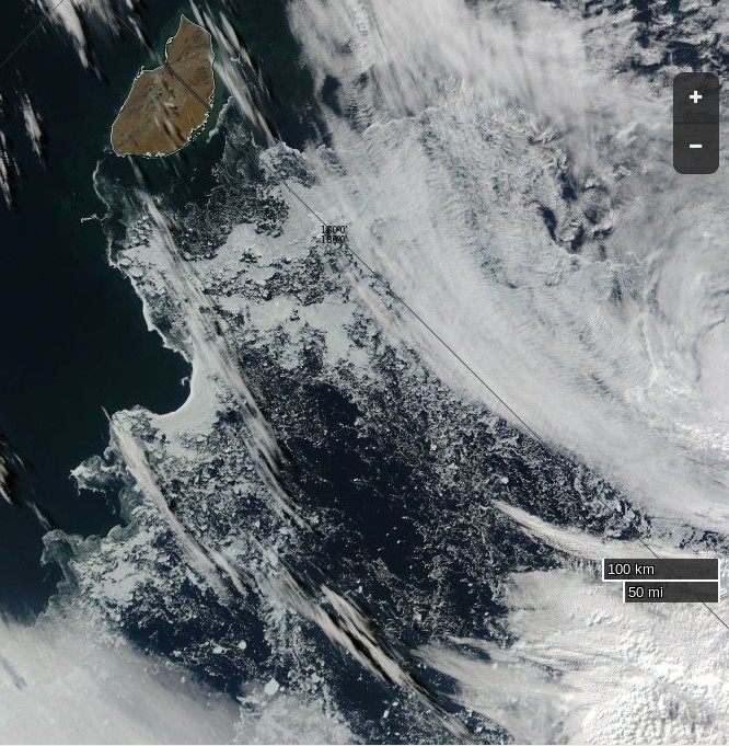
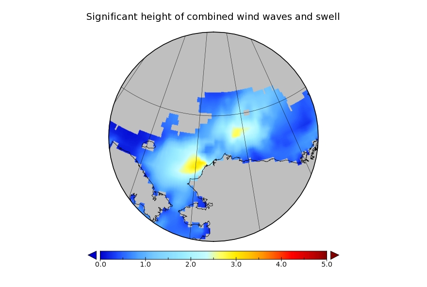
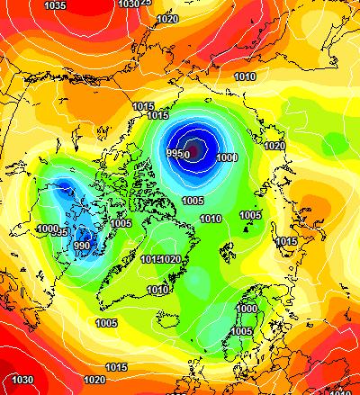
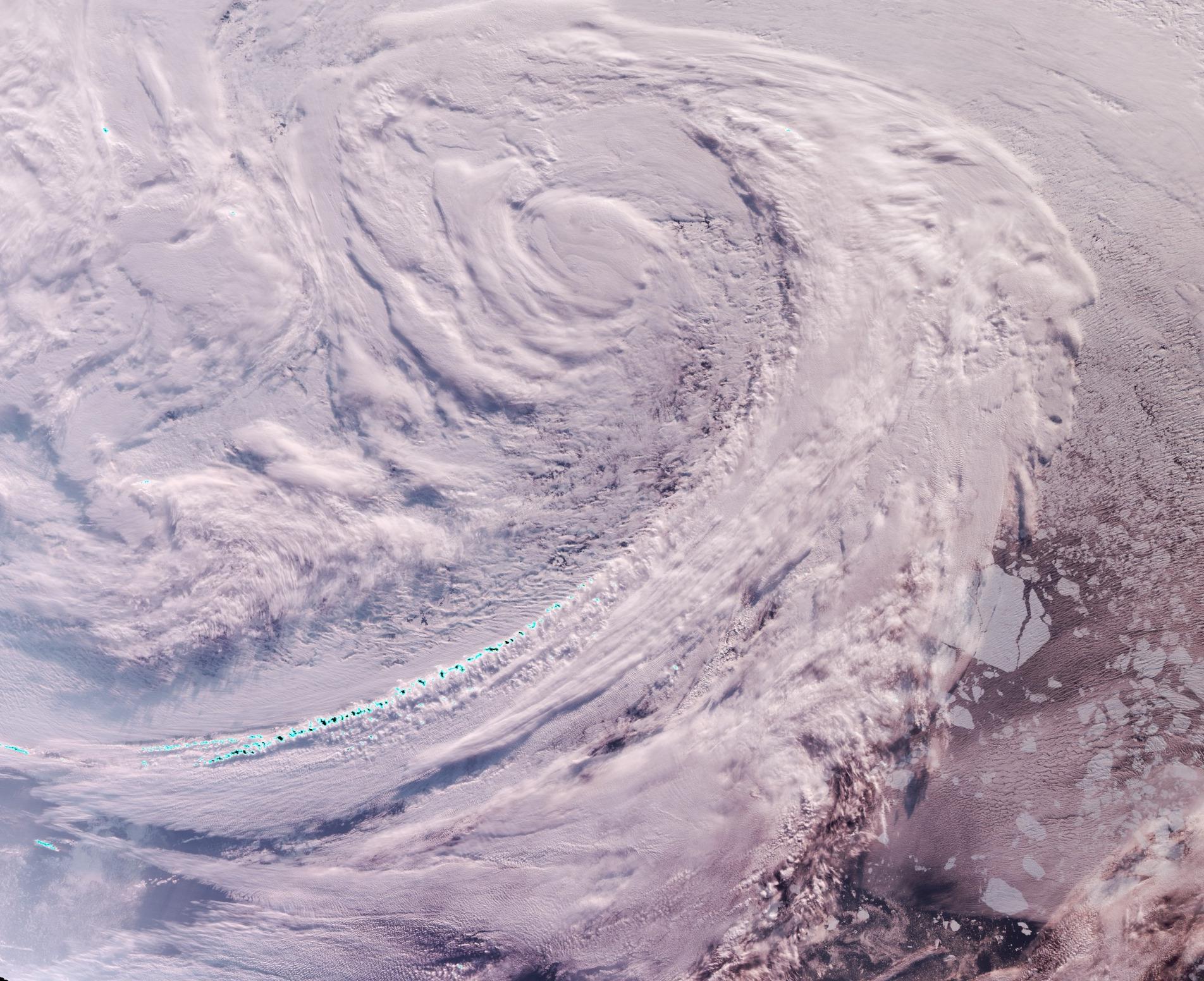
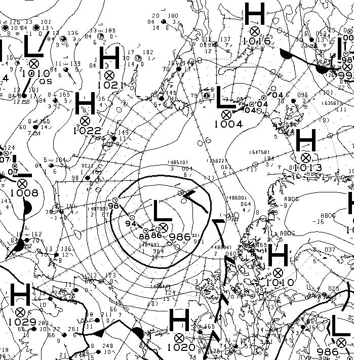
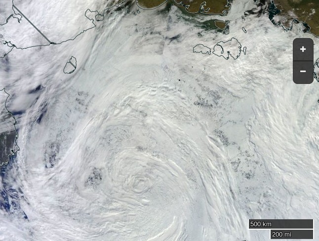
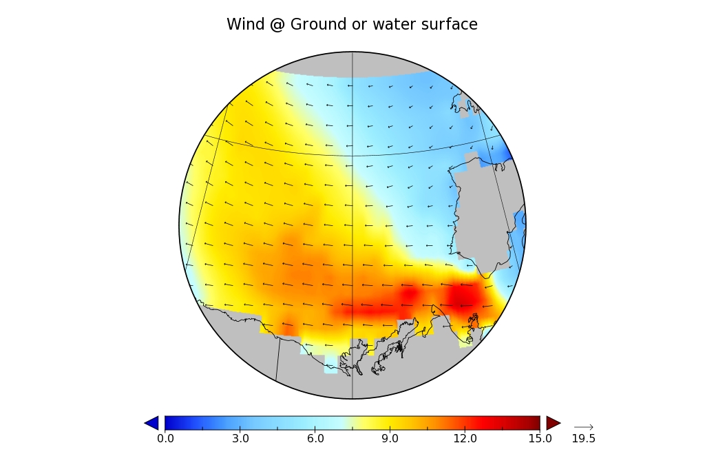
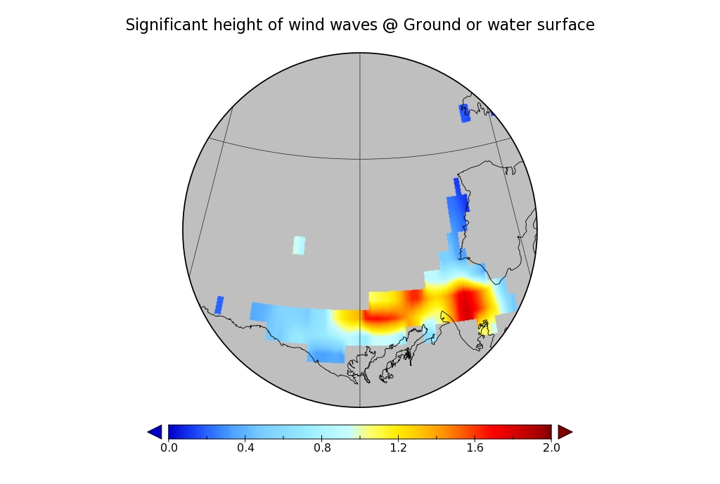
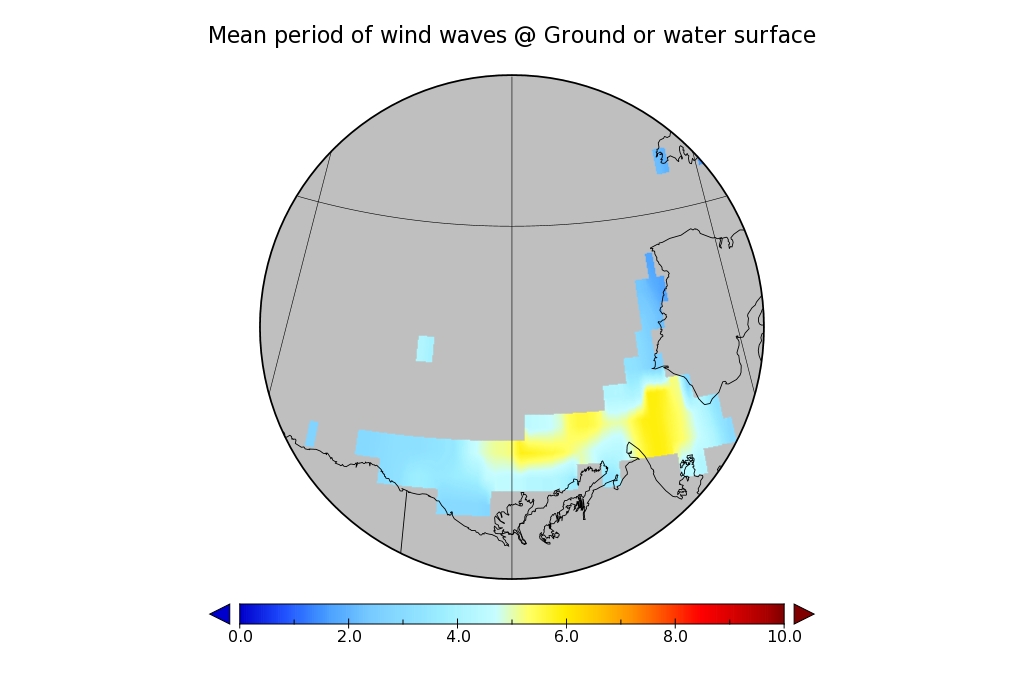
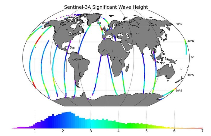
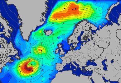
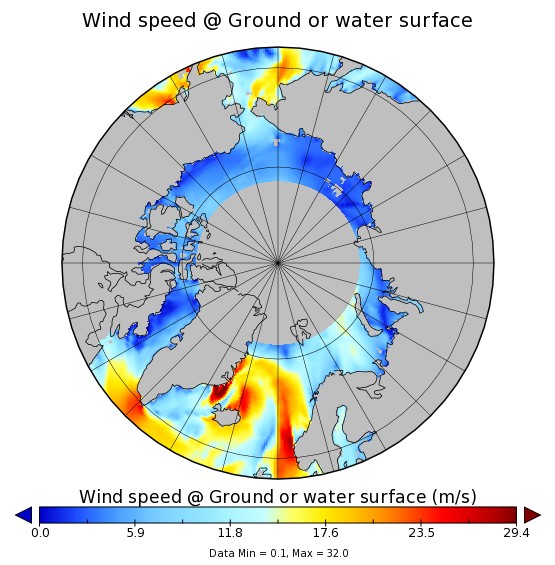
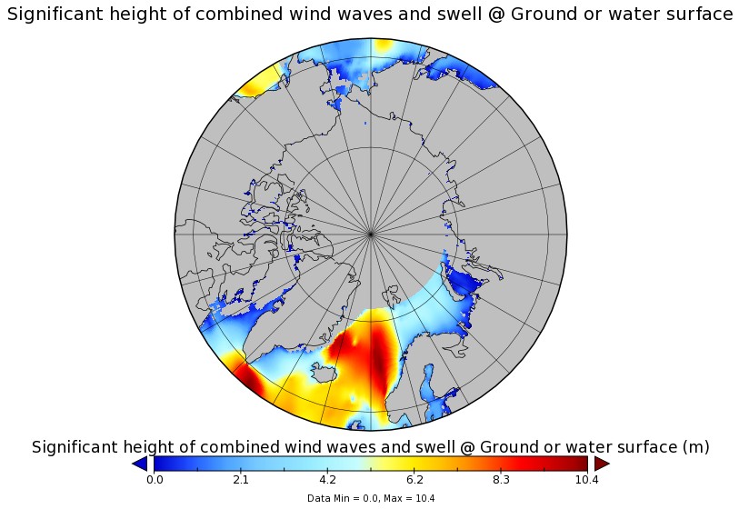
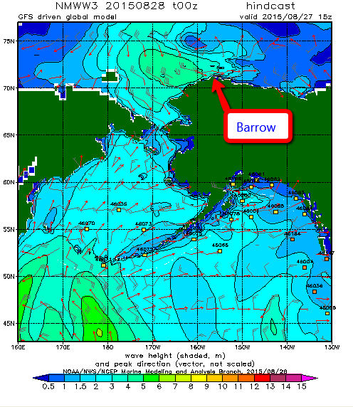
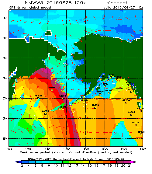
Personally I don’t think those numbers will last long, and here’s one reason why. The “surf forecast” for the far North Atlantic for midday on September 6th:

Significant_height_of_combined_w in multi_1.glo_30mext.20170903_00029

Mean_period_of_swell_waves_order in multi_1.glo_30mext.20170903_00029

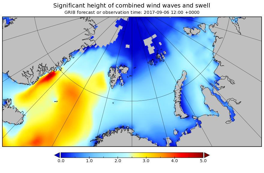
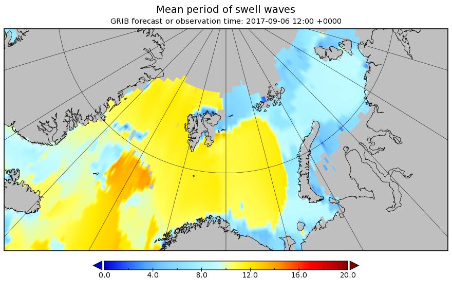
Some significant swells are currently forecast to batter the ice edge on the Atlantic side of the Arctic over the next few days.


[Edit – September 3rd PM]

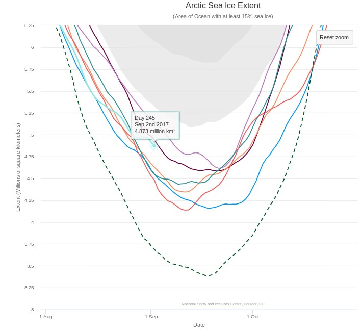
Shock news! Tony Heller has made a prediction about this year’s minimum!! Unlike last year, this year the NSIDC 5 day average extent seems to be his Arctic metric of choice:

Charctic-20170902

Tony tells his faithful flock:

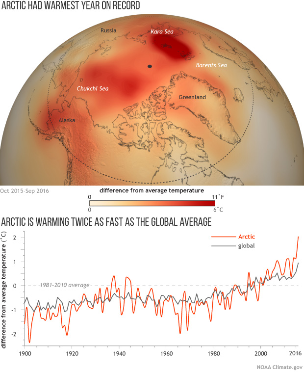
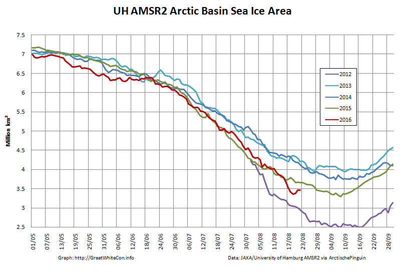
The Arctic sea ice minimum this year is very likely going to be be larger than 2016, 2015, 2012, 2011 and 2007.

It is also likely that the minimum extent will be higher than 2010 and 2008.

Instead of reporting the huge gain in ice and massive failure of their forecasts, climate alarmists will report that extent was “8th lowest on record.”

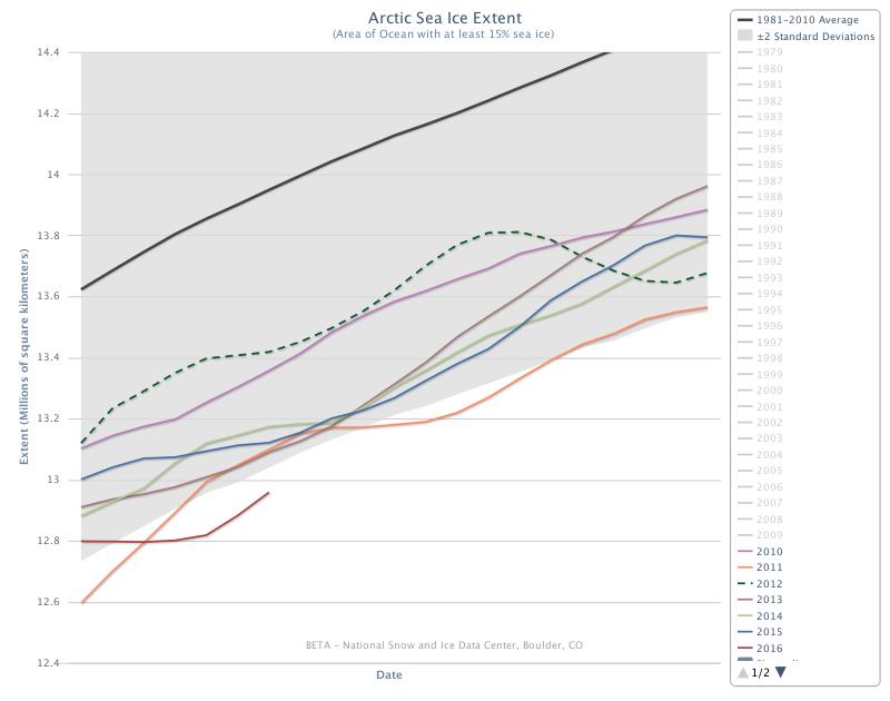
All those years are on the graph above. We shall see.


[Edit – September 15th]

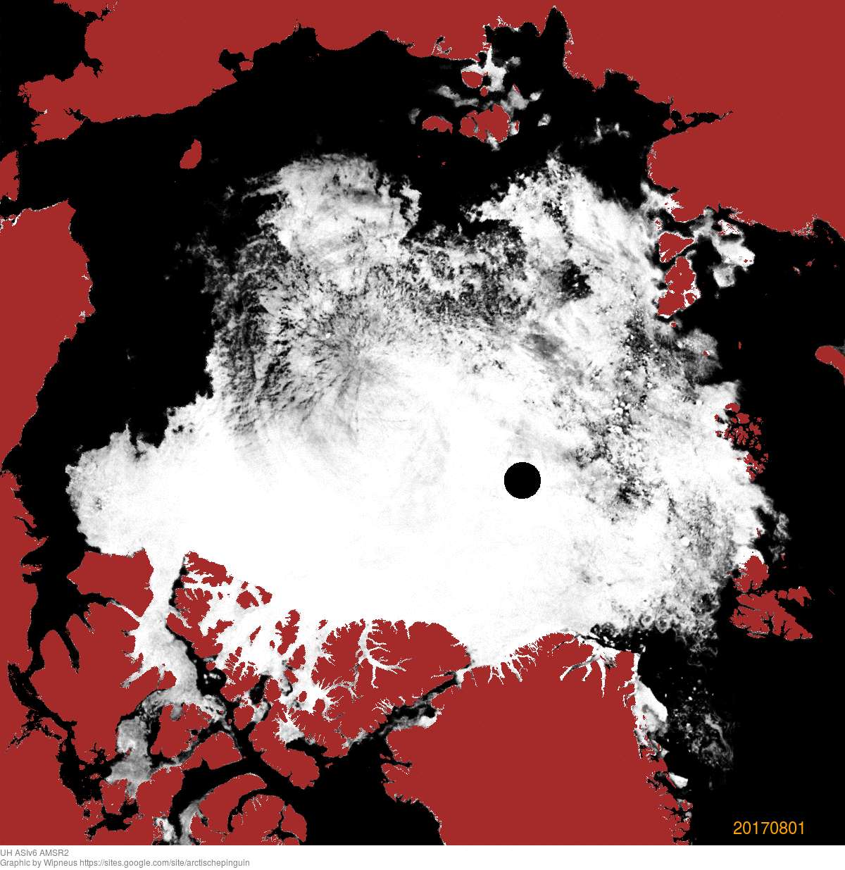
Our normal Arctic sea ice extent 2017 minimum service will be restored as soon as possible. Meanwhile here is the test card:

That comes to you via the Daily Express of all places!

On the way the cruise’s resident naturalist and Smithsonian lecturer, Michael Scott, risked the wrath of Trump supporters by pointing to some of the changes Greenland is undergoing.

A Nasa map based on data between 2004 and 2014 revealed that the ice is melting across most of Greenland – an area nine times the size of the UK.

Pulling together several papers, Michael said Greenland’s summer melt season now lasts 70 days longer than in the early 1970s.

This melting is unfreezing the fringes of the permafrost, which may explain why Nasa satellites are picking up fires raging where the ice has retreated.


[Edit – September 16th]

It is of course still to early to be 100% certain about this. However:

UH-Arctic-Extent-2017-09-15

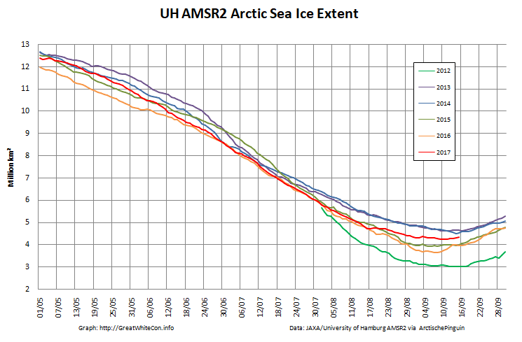
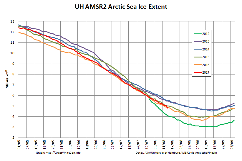
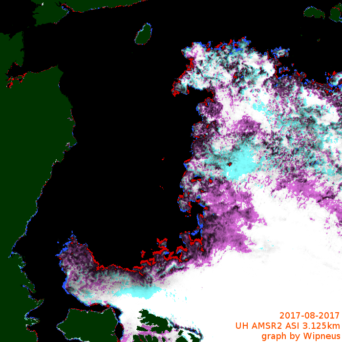
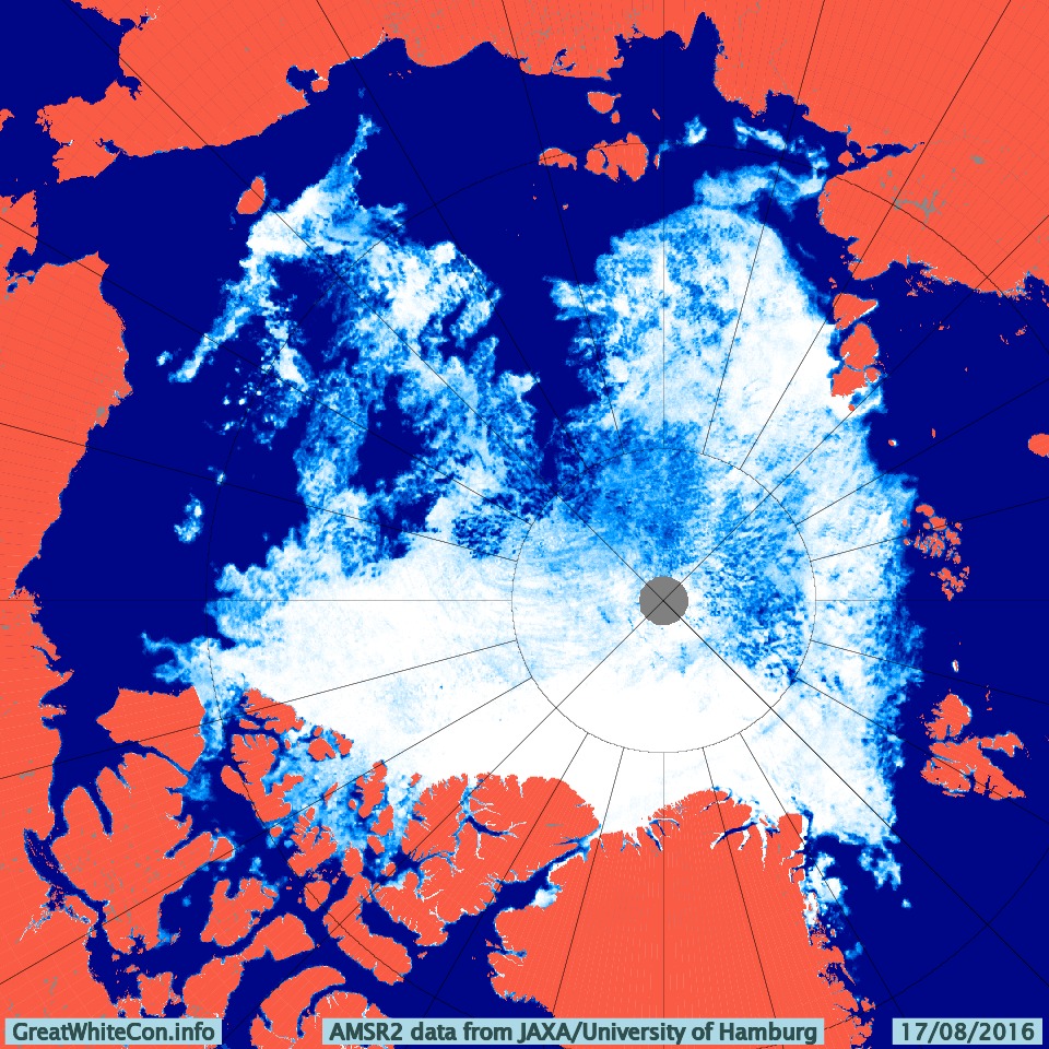
It certainly looks as though the bottom is in for the University of Hamburg AMSR2 extent: 4.25 million km² on September 11th.

It’s much the same story for JAXA extent:

VISHOP_Extent-20170915

4.47 million km² on September 9th and 10th.


[Edit – September 19th]

The NSIDC have followed in Snow White’s glass slippered footsteps and tentatively called the minimum:

On September 13, Arctic sea ice appears to have reached its seasonal minimum extent of 4.64 million square kilometers (1.79 million square miles), the eighth lowest in the 38-year satellite record. The overall rate of ice loss this summer was slowed by a persistent pattern of low sea level pressure focused over the central Arctic Ocean.

Please note that this is a preliminary announcement. Changing winds or late-season melt could still reduce the Arctic ice extent, as happened in 2005 and 2010. NSIDC scientists will release a full analysis of the Arctic melt season, and discuss the Antarctic winter sea ice growth, in early October.

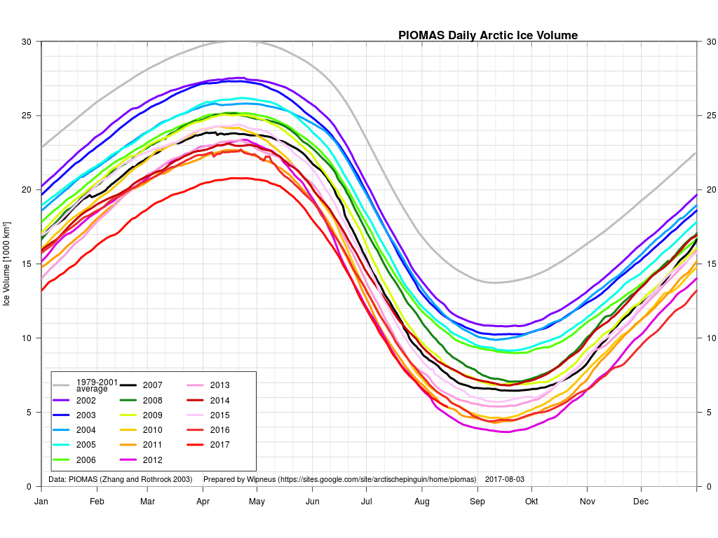
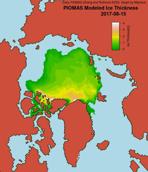
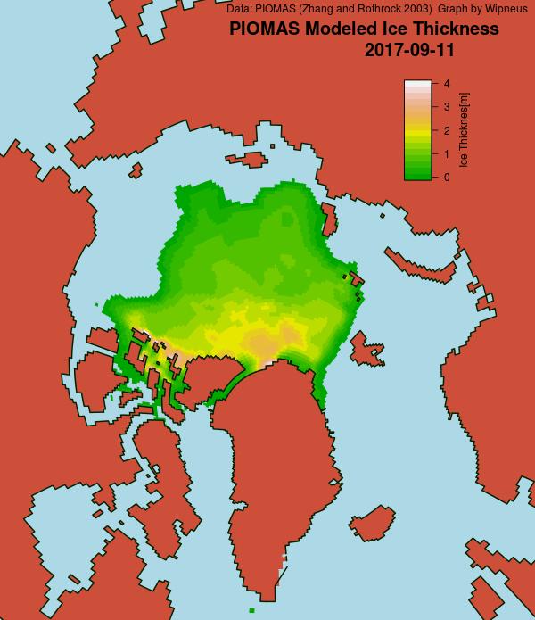
The ever industrious Wipneus has also called the PIOMAS minimum volume for 2017:

Minimum volume was reached at 11th September: 4.542 103km3, which is fourth lowest after 2012, 2011 and 2016 (resp 3.673, 4.302, 4.402) and just below 2010 (4.582).

piomas_gridded_thickness_20170911


[Edit – September 23rd]

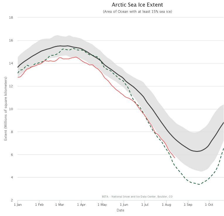
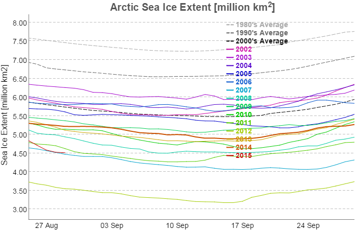
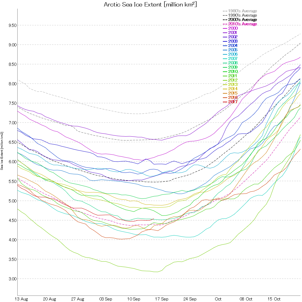
Here’s the 2017 edition of our annual NSIDC daily max/min extent graph:

NSIDC-NH-MaxMin-2017

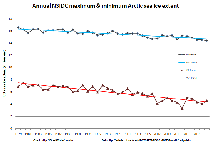
The maximum extent was the lowest in the satellite record, and the minimum was just fractionally above the trend line. For those that concern themselves with “statistical significance”, the PIOMAS minimum volume was a “statistical tie” for second place:

PIOMAS-20170915

Watch this space!

Facts About the Arctic in August 2017

What seems likely to be the most interesting period of the 2017 Arctic sea ice melting season is upon us! The PIOMAS gridded data hasn’t been released yet, but the overall volume numbers reveal that 2017 has now relinquished its “lowest ever” position to 2012. Here’s Wipneus’ graph of the volume data:

piomas-trnd4-20170731

plus his anomaly plot:

piomas-anomaly-20170731

Our favourite high resolution AMSR2 area and extent graphs now also allow comparison with 2012. Here’s how they look at the moment:

UH-Arctic-Extent-2017-08-04

UH-Arctic-Area-2017-08-04

As you can see, round about now is when 2012 Arctic sea ice extent started to noticeably race ahead of the rest of the pack. Will 2017 follow suit? Are there any Arctic cyclones on the horizon for example? Well, the one forecast for August 4th hasn’t materialised. Here’s this morning’s Environment Canada synopsis:

Synopsis-20170804-00Z-Crop

However both ECMWF and GFS agree that a sub 985 hPa storm should have arrived by Sunday morning. Here’s the ECMWF version from MeteoCiel:

ECH1-20170804+48h

There’s stronger storms in the forecast further out, but once again we’ll believe them if and when we see them!

We’re keeping a close eye on the Northwest Passage once again this year. Most of the southern route is open already, but as we predicted the old ice in Larsen Sound has a lot of melting still to do. Here’s how it looked from the icebreaker Nordica a few days ago:

On top of that the old ice around O-Buoy 14 is currently rushing south down the McClintock Channel to replenish it. Here’s how that looks at the moment:

OBuoy14-20170803-0301

Meanwhile the melt along the Northern Sea Route is well ahead of last year. Here’s the University of Hamburg AMSR2 concentration map of the area:

Arc_20170803_res3.125_LARGE

There’s also now a lot of open water on the Pacific side of the Arctic, and Sunday’s cyclone is forecast to create a large area of 2 meter plus waves heading in the direction of the ice edge:

Significant_height_of_combined_w in multi_1.glo_30mext.20170804_00024

I expect that to have a noticeable effect on the already fragile sea ice by early next week, assuming the storm arrives as forecast! There is an ice mass balance buoy handily placed out on the ice in the path of the storm. Buoy 2017A is currently located near 77 N, 147 W, and its assorted sensors suggest the ice underneath it is now less than 20 cm thick:

2017A-2017-07-30

2017A_thick_20170731

Here’s how the area around the buoy looked a couple of weeks ago:


Image of 2017A from WARM 6 on July 18th 2017. NSF project: NSF OPP #1603548

The $64,000 question now is will the 2017 Arctic sea ice metrics stay in amongst the recent pack, or race after 2012 instead?


[Edit – August 6th]

This morning’s synopsis from Environment Canada suggests the cyclone has bottomed out at a MSLP of 982 hPa:

Synopsis-20170806-06Z-Crop

Here’s how the cyclone looked from space yesterday:

NASA Worldview “true-color” image of the sea ice north of the Beaufort Sea on August 5th 2017, derived from the VIIRS sensor on the Suomi satellite

I think that I can convince myself that the salinity profile from ice tethered profiler 97, currently located at 73° N, 134° W, reveals mixing from depth in the wake of the storm:

itp97-Salinity-20170806

The synthetic aperture radar on the Sentinel 1B satellite can certainly see through the clouds, and reveals open water in the Central Arctic north of the Beaufort Sea yesterday evening (UTC):

Sentinel 1B image of Arctic sea ice at 79N, 160W on August 5th 2017
Sentinel 1B image of Arctic sea ice at 79° N, 160° W on August 5th 2017


[Edit – August 7th]

Here is Wipneus’ latest AMSR2 concentration delta map:

AMSR2-Delta-20170806

The effects of this weekend’s storm are readily apparent! Just in case you’re wondering Wipneus reports:

Area: -172.0 (+324k vs 2016, +138k vs 2015, -669k vs 2014, -523k vs 2013, +493k vs 2012)

UH-Arctic-Area-2017-08-06


[Edit – August 8th]

The next pulse of swell is currently forecast to be somewhat higher and longer period than the last one. This one is also taking aim at the Beaufort Sea MIZ:

Significant_height_of_combined_w in multi_1.glo_30mext.20170808-12Z_00045

Mean_period_of_wind_waves_surfac in multi_1.glo_30mext.20170808-12Z_00045


[Edit – August 9th]

According to Environment Canada the latest cyclone is already down to 980 hPa MSLP:

Synopsis-20170808-06Z-Crop


[Edit – August 9th PM]

The MSLP of the current cyclone is now down to 976 hPA:

Synopsis-20170808-18Z-Crop

The latest WaveWatch III forecast has increased the predicted peak height and period of the resulting waves once again:

Significant_height_of_combined_w in multi_1.glo_30mext.20170809_00037

Mean_period_of_wind_waves_surfac in multi_1.glo_15mext.2070809_00037B


[Edit – August 10th]

Large holes are appearing in the sea ice on the other side of the Arctic too. Take a look north of the Laptev Sea for example:

NASA Worldview “true-color” image of the "Laptev Bite" polynya on August 10th 2017
NASA Worldview “true-color” image of the “Laptev Bite” polynya on August 10th 2017

Meanwhile the current cyclone on the Pacific side of the North Pole appears to have bottomed out at 974 hPa:

Synopsis-20170810-06Z-Crop


[Edit – August 11th]

Here’s the latest sea ice concentration one day delta map from Wipneus:

AMSR2-Delta-20170810
Despite the expected divergence caused by a low pressure area crossing the ice, both are and extent of sea ice on the Pacific side of the Arctic are still falling.


[Edit – August 12th]

The waves are considerably smaller in the Beaufort Sea today, but not in the Bering Strait!

Significant_height_of_combined_w in multi_1.glo_30mext.20170812-00Z_00007

Here’s the latest one day delta map:

AMSR2-Delta-20170811

and here’s video showing the motion of sea ice in the Beaufort & Chukchi Seas so far this summer:


[Edit – August 13th]

Here’s an animation from Wipneus revealing the effect of the two recent cyclones on the Pacific side, plus everything else that’s been going on in the Arctic:

AMSR2-Basin-Anim-20170812-600

Click the image to see a much larger (3.3 Mb) version.


[Edit – August 16th]

AMSR2 Arctic sea ice extent has taken another tumble, and has dropped below 2016:

UH-Arctic-Extent-2017-08-15

Only 2012 left to beat!


[Edit – August 18th]

A PIOMAS mid month update has been released, including gridded thickness data. 2017 modelled volume has failed to follow 2012’s trajectory towards the September minimum, and is now on a par with 2011:

piomas-20170815

piomas_thickness_20170815


[Edit – August 21st]

After a “brief hiatus” in the wake of the recent cyclones Arctic sea ice area has posted a new low for the year:

UH-Arctic-Area-2017-08-20

Extent has yet to follow suit:

UH-Arctic-Extent-2017-08-20

The main loss of area has been in the “Beaufort Bite” once again:

AMSR2-Delta-20170820


[Edit – August 24th]

The SIPN August sea ice outlook has been released. Here are the predictions:

Watch this space!

Arctic Sea Ice News from AGU

I just watched the live stream of the fall 2016 AGU press conference about the findings of the “First results from the Norwegian Young Sea ICE Expedition”.

Here’s the associated video of the expedition:

Here are the bullet points:

Initial results suggest that the thinner and younger ice is altogether different from older multiyear ice. It moves faster, breaks up easier, melts faster, and is more vulnerable to storms. This has important consequences for the Arctic as a whole, as our current knowledge is largely based on information from the “old Arctic.”

The Atmosphere

• For the first time, N-ICE2015 researchers directly observed large winter storms over sea ice and saw that they have significant effects on the young, thinner ice. The high winds create a lot of stress on the sea ice by pushing it around and breaking it up.
• One winter storm raised the air temperature from -40 F to +32 F in less than 48 hours, while the moisture in the air increased 10 times. All of these factors significantly warm the surface of the snow, even in mid-winter, and slow the growth of ice.

The Sea Ice and Snow Cover

• Researchers on the drifting ice camps found more snow on top of the ice than expected. This insulated the ice from the atmosphere, slowing its growth in winter and surface melt in summer.
• The sea ice was sometimes flooded by seawater as the large snow load pushed the thinner ice below sea level.
• The thinner sea ice was more dynamic than researchers have seen before. This could mean more ridging but also more cracks and leads between ice floes.

The Ocean

• Winter storms caused the sea ice to drift so fast that it increased mixing of the water beneath the ice. Deeper, warmer water was mixed up closer to the sea ice, causing it to melt from below despite winter air temperatures that were below freezing.
• Researchers saw summer storms stir up deep warm waters and melt as much as 25 cm of ice in a single day.

The Ecosystem

• For the first time, N-ICE2015 researchers observed an algae bloom under snow-covered pack ice. Thinner and more dynamic Arctic sea ice allows more light transmission to the ocean, especially through cracks and leads. This triggers earlier phytoplankton blooms under the snow-covered ice.
• The phytoplankton species that dominated the under-ice bloom does not sink to the deep ocean. Such shifts in phytoplankton species composition, associated with early under-ice phytoplankton blooms, could thus have important implications for the strength of the biological carbon pump in the Arctic.

There was also mention of the “waves in ice” event that the R/V Lance experienced back in June 2015:

lance-waves-2015-1

P.S. A recording of the N-ICE2015 press conference is now available:

Next up on the live stream is was the 2016 “Arctic Report Card“. Here’s the associated video:

No doubt because of the recent controversy concerning the effects of the 2015/16 El Niño the first graphic that caught my eye was this one:

arctictemp_map_graph_2015-16_620

In the question and answer session the obvious question was asked. The answer was that while attribution is difficult the 2015/16 El Niño did have some effect on Arctic sea ice. However currently we’ve only seen “the first act of a 3 act play”. Act 2 will be the maximum extent in March.

In answer to another question, a focus of research over the next 10 years should be the interactions between mid latitudes and the Arctic.

P.S. A recording of the Arctic Report Card press conference is now available:

A variety of cryospheric posters are available via:

https://agu.confex.com/agu/fm16/meetingapp.cgi/Index/EPoster~1/Program/1175

September Arctic Cyclone Alert!

The Central Arctic has of course already been battered by the Great Arctic Cyclone(s) of August 2016. The minimum sea ice extent has been called by the NSIDC, with a slight proviso:

Arctic sea ice appears to have reached its seasonal minimum extent for 2016 on September 10. A relatively rapid loss of sea ice in the first ten days of September has pushed the ice extent to a statistical tie with 2007 for the second lowest in the satellite record. September’s low extent followed a summer characterized by conditions generally unfavorable for sea ice loss.

Please note that this is a preliminary announcement. Changing winds or late-season melt could still reduce the Arctic ice extent, as happened in 2005 and 2010. NSIDC scientists will release a full analysis of the Arctic melt season, and discuss the Antarctic winter sea ice growth, in early October.

On September 10, Arctic sea ice extent stood at 4.14 million square kilometers (1.60 million square miles).

Now, however, yet another cyclone is raging in the Central Arctic. According to Environment Canada this one is already down to a mean sea level pressure of 975 hPa:

synopsis-20160916-06z

As our regular readers will be well aware, at this time of year strong winds beget large swells. On this occasion it looks as though Barrow will get another battering, as well as the remaining and refreezing sea ice. Here’s the current WaveWatch III significant wave height forecast for September 18th:

significant_height_of_combined_w-in-multi_2-glo_30m-20160916_00064

Such large swells on the surface of the Arctic Ocean don’t only physically break up the sea ice. Last September scientists aboard the University of Alaska’s research icebreaker Sikuliaq observed the effects of a similar storm in the Beaufort Sea. According to Jennifer MacKinnon, Chief Scientist on the ArcticMix voyage:

One of the funny things about the Arctic is that there’s a reservoir of heat beneath the surface here.

So the more the wind is blowing on the ocean, the more it’s mixing this heat upwards. Which is bringing warmer water to the surface at a pretty rapid rate, warming the surface and accelerating the rate at which this ice is melting.

And if storms like this continue, as there’s more open water, more storms mean more exposed surface. It will not only melt the ice in the summer, but delay the onset of fall ice formation and accelerate the onset of spring ice melting.

In October 2015 the Sikuliaq was back in the Beaufort Sea observing the effect of storm swells on refreezing sea ice. Here’s a report from Chief Scientist Jim Thomson:

A strong easterly wind event came through that built large waves — waves that got to almost five meters in height. And the winds were something like up to thirty knots. And these waves were coming into the newly forming ice and making pancake ice.

There was a very warm layer of water 20 meters down beneath the surface. And these waves coming in were enough to drive additional mixing and bring that warm water up from the subsurface and that warm water melted the ice and changed that balance happening at the surface.

As if all that wasn’t already enough to worry about look who’s waiting in the wings. Tropical Storm Ian is heading towards the Arctic Circle at a rate of knots, even as we speak:

ian-track-20160916


[Edit – September 17th]

Here is the official Barrow surf forecast from the National Weather Service:

SURF ZONE FORECAST
NATIONAL WEATHER SERVICE BARROW AK
0500 AM AKDT SAT SEP 17 2016

AKZ202-171230-
NORTHERN ARCTIC COAST
INCLUDING THE BEACHES OF BARROW…PITT POINT…NULAVIK
0500 AM AKDT SAT SEP 17 2016

.TODAY AND TONIGHT…
.WIND… WESTERLY 20 TO 35 MPH.
.SURF HEIGHT… 2 TO 5 FT.
.SURF TEMP… 36 DEGREES F.
.TIDES… LOW SAT 0826 AM -0.03
HIGH SAT 0230 PM 0.38
LOW SAT 0846 PM -0.02
HIGH SUN 0250 AM 0.38

There is also a severe weather warning in place:

…HIGH SURF ADVISORY REMAINS IN EFFECT UNTIL 6 AM AKDT MONDAY…

* WAVES AND SURF…WAVES TO 10 FEET BREAKING JUST OFFSHORE COMBINED WITH TIDES UP TO 1 FOOT ABOVE NORMAL WILL CAUSE HIGH SURF CONDITIONS.

* ICE…WITH ICE JUST OFF SHORE FROM BARROW…IT IS POSSIBLE THAT CHUNKS OF SEA ICE WILL WASH UP ON SHORE EVEN WITH WINDS PREDICTED TO BE AT NEARLY PARALLEL TO THE SHORE.

* WINDS…WEST 20 TO 30 MPH FROM THIS AFTERNOON THROUGH EARLY MONDAY MORNING.

* TIMING…HIGH SURF IS EXPECTED TO BEGIN LATE THIS AFTERNOON AND CONTINUE THROUGH EARLY MONDAY.

* IMPACTS…HIGH SURF WILL WASH TO THE TOP OF THE BEACH AND CAUSE BEACH EROSION. MINOR FLOODING OF LOW LYING AREAS IS POSSIBLE AND SURF COULD WASH ONTO LOW LYING ROADS NEAR THE BEACH.

PRECAUTIONARY/PREPAREDNESS ACTIONS…

A HIGH SURF ADVISORY MEANS THAT LOCALIZED BEACH EROSION IS EXPECTED. SURF COULD WASH ONTO LOW LYING ROADS NEAR THE BEACH LIMITING TRAVEL NEAR THE BEACH. PEOPLE SHOULD MOVE BOATS AND PERSONAL PROPERTY INLAND FROM THE BEACH.


[Edit – September 19th]

Somewhat belatedly, before:

barrowcam_20160917_184400

and after:

barrowcam_20160918_212400

the storm images from the Barrow webcam, which has just burst back into life. Plus an image of the cyclone from on high:

NASA Worldview “true-color” image of the Beaufort Sea on September 18th 2016, derived from the VIIRS sensor on the Suomi satellite

The Great Arctic Cyclone of 2016

A storm is brewing in the Arctic. A big one! The crew of the yacht Northabout are currently sailing along the western shore of the Laptev Sea and reported earlier today that:

The sea is calm. Tomorrow a gale 8. But this moment is perfect.

That perfect moment will not last long. Here is the current ECMWF forecast for midnight tomorrow:

ECMWF-20160813+48

and here is the current Arctic surf forecast for 06:00 UTC on Monday:

height_20160813+55h

period_20160813+55h

A 975 hPa low pressure system will be creating 3 meter waves with a period of around 8 seconds heading across the East Siberian Sea in the direction of the ice edge. By midnight on Monday the cyclone is forecast to have deepened to a central pressure below 970 hPa:

ECMWF-20160813+3d

All of this is rather reminiscent of the “Great Arctic Cyclone” in the summer of 2012, which looked like this on August 7th:

ECMWF-20120807

and which ultimately led to the lowest Arctic sea ice extent in the satellite record. Using the National Snow and Ice Data Center’s numbers that was 3.41 million square kilometers on September 16th 2012. Here’s the NSIDC’s current graph comparing 2012 with this year:

Charctic-20160813

I wonder what the minimum for 2016 will be, and on what date?


[Edit – August 14th]

The cyclone is currently centred near Severnaya Zemlya, and the central pressure is down to 981 hPa according to Environment Canada:

Synopsis-20160814-06Z

Northabout is sheltering from the storm.


[Edit – August 15th]

Here’s how the Great Arctic Cyclone of 2016 looks from on high this morning:

NASA Worldview “true-color” image of the 'Great Arctic Cyclone' on August 15th 2016, derived from the VIIRS sensor on the Suomi satellite
NASA Worldview “true-color” image of the ‘Great Arctic Cyclone’ on August 15th 2016, derived from the VIIRS sensor on the Suomi satellite

The latest synopsis from Environment Canada shows that the central pressure of the cyclone is now down to 974 hPa:

Synopsis-20160815-00Z

The WaveWatch III forecast for noon today UTC confirms the forecast of two days ago:

Significant_height_of_combined_w in multi_2.glo_30m.20160815_00013

Mean_period_of_wind_waves_surfac in multi_2.glo_30m.20160815_00013

u-component_of_wind_surface in multi_2.glo_30m.20160815_00013

P.S. The Canadian 0600Z synopsis has the cyclone’s SLP down to 971 hPa:

Synopsis-20160815-06Z


[Edit – August 16th]

This morning the cyclone’s SLP is down to 969 hPa:

Synopsis-20160816-00Z

and the clouds over the Central Arctic are parting:

NASA Worldview “false-color” image of the Arctic Basin on August 16th 2016, derived from the MODIS sensor on the Terra satellite

Our favourite method of seeing through the clouds using the AMSR2 maps from the University of Hamburg doesn’t seem to working at the moment, so here’s one from the University of Bremen instead:

asi-AMSR2-n6250-20160815-v5_nic

P.S. The University of Hamburg high resolution AMSR2 maps are up and running again:

Arc_20160815_res3.125


[Edit – August 17th]

According to Environment Canada the cyclone central pressure bottomed out at 968 hPa yesterday:

Synopsis-20160816-06Z

However, over on Twitter there is this:


[Edit – August 18th]

The cyclone central pressure is now up to 983 hPa, and some indications of the effect it has had on the sea ice in the Arctic are being revealed:

Arc_20160817_res3.125

UH-Arctic-Area-2016-08-17


[Edit – August 19th]

According to Environment Canada the cyclone’s central pressure rose to 985 hPa earlier today:

Synopsis-20160819-00Z

However the 987 hPa low near the Canadian Arctic Archipelago is currently forecast to deepen below 980 hPa over the next 24 hours. Here’s the ECMWF forecast for first thing tomorrow morning:

ECMWF-20160719+1d

The high resolution AMSR2 Arctic sea ice area has reduced by another 133.5 thousand square kilometers since yesterday. A similar drop tomorrow will take us below the 2015 minimum.


[Edit – August 19th PM]

The MSLP of the rejuvenated cyclone had dropped to 976 hPa by 12:00 UTC today:

Synopsis-20160819-12Z

The ECMWF forecast for lunchtime tomorrow is for something similar:

ECMWF-20160719-12Z+1d


[Edit – August 20th]

The current incarnation of the cyclone bottomed out at 971 hPa near the Canadian Arctic Archipelago:

Synopsis-20160820-00Z

The 72 hour forecast from ECMWF for the next phase of GAC 2016 is beginning to enter the realms of plausibility. Here’s what it reveals:

ECMWF-20160720+3d

“Wipneus” reports on the Arctic Sea Ice Forum that:

BREAKING NEWS: Uni Hamburg is releasing AMSR2 sea ice concentration data from 2012. August 1-13 until now.

so here are the latest high resolution AMSR2 metrics, now with added 2012!

UH-Arctic-Area-2016-08-19

UH-Arctic-Extent-2016-08-19

The effect on area of the Great Arctic Cyclones of 2012 and 2016 is evident, but 2016 extent looks to have a lot of catching up to do.


[Edit – August 22nd]

Phase 3 of GAC 2016 started with 4 lows in a row this morning:

Synopsis-20160822-06Z

which have now resolved into a cyclone with 971 hPa MSLP:

Synopsis-20160822-18Z

Note also the high pressure area over Greenland, and Reggie’s developing dipole. I wonder what tomorrow will bring?


[Edit – August 23rd]

MSLP is down to 970 hPa this morning, and the CAB Low / Greenland High dipole is still evident:

Synopsis-20160823-00Z

Hence the GFS forecast of a “blowtorch” on the Pacific side of the Arctic by the weekend:

CCI-T2-20160823+4d

and the US Navy’s ACNFS ice drift forecast for today:

ACNFS-Drift-2016082118_2016082300

The University of Hamburg have been processing more AMSR2 data from 2012. You can argue until the cows come home about which is the best metric to peruse at this time of year, but try this one for size:

UH-Basin-Area-2016-08-22

That’s the high resolution AMSR2 sea ice area for the Arctic Basin, comprising the CAB plus Beaufort, Chukchi, East Siberian and Laptev Seas.


[Edit – August 25th]

There’s a bit of a gap in the clouds over the Central Arctic today:

NASA Worldview “true-color” image of the Central Arctic Basin on August 25th 2016, derived from the MODIS sensor on the Terra satellite

This is merely the calm before the next storm. Here is the current ECMWF forecast for Saturday lunchtime (UTC):

ECMWF-20160825-12Z+2d

Low pressure on the Siberian side of the Arctic and high pressure on the Canadian side producing an impressive dipole with lots of sea ice “drift” towards the Atlantic:

ACNFS-Drift-2016082518_2016082700


[Edit – August 27th]

Saturday morning has arrived, and so has the predicted storm. As the centre of the cyclone crossed the coast of the East Siberian Sea its central pressure had fallen to 967 hPa, whilst the high pressure over Alaska had risen to 1028 hPa:

Synopsis-20160827-00Z

The effect of the earlier bursts of high wind is apparent in the high resolution AMSR2 sea ice area graph:

UH-Arctic-Area-2016-08-26

However they are not as apparent in the corresponding extent graph:

UH-Arctic-Extent-2016-08-26


[Edit – August 28th]

As the centre of the cyclone heads for the North Pole the isobars are tightening across the last refuge of multi-year sea ice north of the Canadian Arctic Archipelago and Greenland:

Synopsis-20160828-06Z

The area north of the East Siberian Sea that was predicted to bear the brunt of the wind and waves overnight is still covered in cloud. However the latest AMSR2 update from the University of Hamburg suggests that open water now stretches as far as 86 degrees north:

Arc_20160827_res3.125

The skies over the northern Chukchi Sea have cleared to reveal this:

NASA Worldview “true-color” image of the northern Chukchi Sea on August 28th 2016, derived from the MODIS sensor on the Aqua satellite


[Edit – August 29th]

Some of the effects of the recent high winds can be judged by this Canadian Ice Service chart of ice concentration near the North Pole:

Pole_20160828180000


[Edit – September 1st]

Arctic sea ice area continues to fall quickly for the time of year:

UH-Arctic-Area-2016-08-31

The recent dipole has finally caused some compaction of the scattered sea ice. Hence the high resolution AMSR2 extent is following suit and is now below last year’s minimum:

UH-Arctic-Extent-2016-08-31

The Mid July Surf Forecast for the Beaufort Sea

It looks like a storm is brewing in the Arctic. The long range weather forecasts for the Arctic have been remarkably unreliable recently, but this one is for a mere three days from now. WaveWatch III suggests there will be some significant waves in the Chukchi and Beaufort Seas this coming weekend, travelling in the direction of the ice edge:

WaveWatch III wave height forecast for July 17th
WaveWatch III wave period forecast for July 17th
WaveWatch III wind forecast for July 17th


[Edit July 15th 2016]

Sunday is only two days away now, and here is the current ECMWF prognosis:

Here’s how “the surf” looks today, courtesy of United States Coast Guard Cutter Healy:


[Edit July 16th 2016]

Another day has dawned, and the Environment Canada synoptic chart shows that the low pressure system currently over the Arctic has reached a central pressure of 990 hPa:

Synopsis-20160716-06Z

The latest ECMWF SLP forecast for tomorrow is firming up:

ECMWF-20160716+1d

A modest swell is now visible from USCGC Healy’s “AloftCon” webcam:

whilst the WaveWatch III forecast for tomorrow has dropped off to a significant wave height of around 2 metres with an average period of 7 seconds:

Height-20160716+1d

Period-20160716+1d

Meanwhile an image from the VIIRS instrument on the Suomi NPP satellite reveals the current storm in all its glory, together with confirmation that the “Big Block” multi-year ice floe north of Barrow has split asunder overnight:

Storm-VIIRS-20160716


[Edit July 17th 2016]

Sunday morning has now arrived. The storm in the Arctic looks to have bottomed out at 986 hPa central pressure. Here’s the Environment Canada synoptic chart for 00:00 this morning:

Synopsis-20160717-00Z

and here’s how the storm looks from the Terra satellite today:

Storm-Terra-20160717-1

This is how the resultant swell looked from USCGC Healy at 06:00:


[Edit July 18th 2016]

Here’s what the Beaufort and Chukchi Sea north of Barrow look like this morning through the clouds:

NASA Worldview “true-color” image of the Beaufort Sea on July 18th 2016, derived from the MODIS sensor on the Terra satellite

The remains of the now not so “Big Block” can just be made out in the bottom left. For a cloud free image here’s the latest AMSR2 passive microwave imagery of the area from the University of Hamburg:

Arc_20160717_res3.125_LARGE

The USCGC Healy and the remnants of the swell are in amongst the ice:


[Edit July 20th 2016]

As the remnants of the storm head off across the Canadian Arctic Archipelago here is what it has left in its wake in the Central Arctic Basin:

NASA Worldview “false-color” image of the Central Arctic Basin on July 19th 2016, derived from the MODIS sensor on the Aqua satellite
University of Hamburg AMSR2 concentration visualisation of the Central Arctic on July 19th 2016

UH-CAB-Extent-2016-07-19

UH-CAB-Area-2016-07-19


[Edit July 21st 2016]

The storm has dispersed the remaining ice in the Beaufort Sea over the last few days:

UH-Beaufort-Extent-2016-07-20

However across the Arctic as a whole sea ice area continues its downward trend:

UH-Arctic-Area-2016-07-20

Wind Waves in the Beaufort Sea in April 2016

As regular readers will be aware we have been following the progress of the Great Arctic Anticyclone of 2016 for the last 3 weeks or so and the generation of increasingly large waves in the Beaufort Sea in August and September for the last 3 years or so. Today we combine the two to bring you news of anomalously large waves in the Beaufort Sea earlier this week. In actual fact any sort of waves in the Beaufort Sea at this time of year would be anomalous, since normally the Beaufort is still covered in sea ice in April!

Firstly a bit of background information. In the continuing absence of the DMSP F-17 satellite data used by the NSIDC for their Arctic sea ice metrics, here’s a close up look at Arctische Pinguin’s current Beaufort Sea ice area data:

2016-04-28-Beaufort-AMSR2-Area

Now here’s NOAA’s WaveWatch III “hindcast” of the winds over the Beaufort Sea on April 26th 2016:

WaveWatch III wind hindcast for the Beaufort Sea on April 26th 2016

Notice the continuing easterly winds from the persistent high pressure system centred to the north of the Beaufort Sea. Next here’s the resultant wind wave height:

WaveWatch III wave height hindcast for the Beaufort Sea on April 26th 2016

and the associated wind wave period:

WaveWatch III wave period hindcast for the Beaufort Sea on April 26th 2016

Wind waves with a height of around 1.5 meters and a period of 6 seconds wouldn’t tempt me to go out on a surfing expedition, but they would certainly be enough to interfere with the sea ice formation process, as you can see from this “pseudo-color” image of the Beaufort Sea on April 26th from the MODIS instrument on the Terra satellite:

NASA Worldview “false-color” image of the Beaufort Sea on April 26th 2016, derived from the MODIS sensor on the Terra satellite

Unfortunately the Jason 2 and recently launched Jason 3 satellites don’t measure wave heights in bodies of water as far north as the Beaufort Sea, so we’ll have to content ourselves with the modelled data from WaveWatch III. However here’s a brief video explaining how Jason 3 measurements are now used to assist WaveWatch forecasts further south:

Whilst Jason 3 won’t be watching waves in the Arctic Ocean it looks as though the European Space Agency’s Sentinel 3A satellite will be providing wave height data for the Beaufort Sea in the not too distant future:

S3A_Wave_height_20160304

It also looks as though CryoSat-2 is already potentially providing such data, but as far as I can ascertain it’s not available in handy gridded format in the same way that the CS2 near real time ice thickness data is.

Vanishing Svalbard Sea Ice

At the turn of the year we speculated about the potential effect of high temperatures and the swells caused by strong winds on sea ice in the Fram Strait and Barents and Greenland Seas. With the vernal equinox rapidly approaching let’s take stock of the state of Svalbard sea ice. Here’s one the first “visual” satellite images of the area in 2016 recorded yesterday by the Aqua satellite:

NASA Worldview “true-color” image of the Central Arctic north of Svalbard on March 14th 2016, derived from the MODIS sensor on the Aqua satellite

and here is the equivalent sea ice map from the Norwegian Meteorological Institute:

Svalbard-Map-20160314

Both sources reveal an unseasonable lack of solid sea ice around Svalbard. In fact an intrepid Northwest Passage navigator who didn’t mind the dark might well currently be able to circumnavigate Svalbard!

The Norwegian Meteorological Institute also produce a time series of sea ice area in the Svalbard region based on data from OSI-SAF. It currently looks like this:

osisaf-svalbard_20160314

As sunlight returns to the Central Arctic north of 80 degrees there is an anomalously large area of open water ready to soak up the rays. Here is what the Danish Meteorological Institute timeseries of Central Arctic temperatures looks like at the moment:

DMI-meanT_20160314

and here is the current Svalbard surf forecast from Magic Seaweed:

MSW-20160315

Whilst we speculate on what all this might mean for the Atlantic side of the Arctic over the coming melting season, here’s our new Svalbard Sea Ice page which contains a variety of graphs and maps to help us keep track of events on that part of our planet.

New Year 2016 Arctic Meltdown Update

On January 1st 2016 the 15% concentration threshold daily Arctic sea ice extent metric reported by the United States National Snow and Ice Data Centre reached the lowest ever level for the first day of any year since their satellite derived records began in 1979. A couple of days later the more familiar 5 day trailing averaged extent also reached the lowest ever level for the date:

Charctic-20160107

Cryosphere Today have been somewhat sluggish about updating their records of Arctic sea ice area, but have at long last revealed that their metric is now also at the lowest ever level for the date:

CT-NH-20160107

Meanwhile Great White Con commenter “Just A Thought” states that:

I find it hard, with what I do have access to, to see why everyone is so worried that the Arctic is melting.

He or she has evidently only had access to the propaganda perpetrated by Tony Heller (AKA “Steve Goddard”) on his so called “Real Climate Science” blog. Mr. Heller’s latest Arctic pronouncement on December 31st 2015 is entitled “Arctic Meltdown Update” and claims that:

Experts say that a terrifying storm melted the North Pole yesterday. This unprecedented melting event has caused Arctic ice to reach its highest December extent in over a decade.

justifying that comment with the following graph of his beloved (albeit deprecated) 30% concentration threshold DMI extent metric:

DMI-30-2015-12-31-

Here’s a video revealing the effect of the recent “terrifying storm” on the sea ice on the North Atlantic side of the Arctic:

As you can see the ice at the North Pole didn’t melt away. However the ice edge did retreat in the immediate aftermath of what is referred to here in the United Kingdom as “Storm Frank“. Frank led to lots of flooding in the North of the nation, and also to some strong winds inside the Arctic Circle:

WW3Wind-20151230-1400

Those winds, travelling over a long stretch of open ocean, produced some pretty significant waves, speeding in the direction of the sea ice edge:

WWIII-20151231-0000

Meanwhile temperatures near the North Pole did briefly rise above the freezing point of sea ice in the middle of the Arctic winter. Here’s the Danish Meteorological Institute’s view of the air temperatures in the central Arctic:

meanT_20151231

and here is NOAA’s temperature anomaly reanalysis for December 30th 2015:
NOAA-anomT_20151230

Personally I reckon the 25 m/s winds and resulting 10 meter waves had more effect on the sea ice metrics than the 25 °C above normal air temperatures, but your mileage may of course vary, especially if your pseudonym is “Steve Goddard”!

Barrow Battered By Big Waves

The first big waves of 2015 have been battering the town of Barrow, Alaska today and they’ve already broken through the coastal defences. Firstly take a look at the view from the Barrow webcam during a less damaging storm on September 4th last year:

BarrowCam_20140904_0834

Now take a look at the view from the same camera earlier today, and play “spot the difference” with me:

BarrowCam_20150827_1749

The cause of the flooding that is all too visible is a cyclone that’s been whirling around in the Chukchi Sea for a while, and here is a WaveWatch III “hindcast” of what the resultant winds have created in the way of waves. Firstly the “significant wave height”:

alaska_height_20150827_015h

and now the “peak period”:

alaska_period_20150827_015h

which reveal a swell 4 to 5 metres high with a period of 10 seconds heading directly towards Barrow Beach. According to the Alaska Dispatch News:

Huge, wind-whipped waves crashed onto the shore at Barrow on Thursday, forcing the closure of a nearby road. Westerly winds were gusting up to 50 miles an hour, pushing waves up to the top of the beach and causing some erosion, the National Weather Service said.

The service has issued a coastal flood warning for Barrow until Friday morning, along with a high surf advisory for the western part of the North Slope and a gale warning for much of the Beaufort and Chukchi Seas.

The big surf and flooding, which has covered a road that runs between the ocean and Barrow’s lagoon, is “not terribly unusual” at this time of the year, said Ryan Metzger, a National Weather Service meteorologist in Fairbanks. Fall is a stormy season, and the timing — right around the annual minimum sea ice extent — allows the surf to build and reach shore.

Photograph by Brittni Driver via Alaska Dispatch News

Just in case it’s not obvious from all the pictures, the respective advisory messages point out that:

A COASTAL FLOOD WARNING MEANS THAT RISING SEA WATER THAT CAUSES FLOODING IS EXPECTED. COASTAL RESIDENTS IN THE WARNED AREA SHOULD BE ALERT FOR RISING WATER…AND TAKE ACTIONS TO PROTECT LIFE AND PROPERTY.

A HIGH SURF ADVISORY MEANS THAT LOCALIZED BEACH EROSION IS EXPECTED. PRECAUTIONS SHOULD BE TAKEN TO PROTECT PROPERTY.

If you’re now wondering what might happen to other areas of the north coast of Alaska in similar circumstances, but with no bulldozer in attendance, here’s an example from Cape Halkett:

According to to the United States’ Climate Resilience Toolkit:

Thawing permafrost causes coastline collapse on Alaska’s North Slope, which is no longer kept frozen and protected from fall storms by sea ice—the ice now forms later in the season.

Away from the coast swell from the same cyclone has also been affecting the sea ice north of Barrow, and here’s what a webcam bobbing about on a buoy north of the Chukchi Sea showed as the winds started to build yesterday:

O-Buoy 12 image from August 26th 2015

O-Buoy 12 has now tipped over and then ceased transmitting. This is the last picture received, in the early hours of August 27th when the wind speed had reached 13 m/s and the buoy had been moving at over 5 m/s:

OBuoy12-20150827-1

Once upon a time O-Buoy 12 was sat on the same ice floe as ice mass balance buoy 2014G, which has also been free floating for a while. Here’s what it reveals about the temperature of the sea water on August 26th 2015 at 77.56 N, 163.86 W:

2015-08-26_2014G

Somewhere in the vicinity of -0.7 °C.

[Edit on 30/08/2015]

O-Buoy 12 has made no further transmissions, and therefore seems to have succumbed to the storm. In addition IMB buoys 2014F and 2013F stopped transmitting on the 26th and 27th of August respectively. Ice mass balance buoy 2014G has survived however, and reports two successive record daily distances travelled:

2015-08-29-2014G-Map

25.6 km on August 26th, followed by 36.3 km on the 27th. After a brief dip during the cyclone water temperature is still around -0.7 °C.

Presumably as a result of the cyclone JAXA Arctic sea ice extent has taken a tumble over the last few days. It has stabilised this morning slightly above 2007 levels:

JAXA-aug29

Here is the current AMSR2 Arctic sea ice concentration map from the University of Hamburg, revealing a large potential fetch across the East Siberian, Chukchi and Beaufort Seas should any further cyclones occur in the area over the next few weeks:

AMSR2 Arctic sea ice concentration on August 29th from the University of Hamburg

Hence the conditions now exist for an even more damaging swell to be generated before the 2015 minimum Arctic sea ice extent is reached.