Skeptical sorts across the cryoblogosphere are in meltdown mode at the moment. They seem to be unaware that satellites don’t last forever in the harsh environment of space, and the individual scientific instruments carried by a satellite don’t either. Some failures are more spectacular than others however. By way of illustration here’s one recent report from Space.com:
The February [2015] explosion of an American military satellite may cause some problems for orbiting spacecraft after all, a new study reports.
The U.S. Air Force’s 20-year-old Defense Meteorological Satellite Program Flight 13 (DMSP-F13) craft blew apart on Feb. 3 after experiencing a power-system faillure. Analyses by the European Space Agency and other organizations found that the cloud of space junk generated by the explosion shouldn’t pose much of a threat to their missions, but the new research suggests that not all spacecraft are in the clear.
Another DMSP satellite started pushing up the metaphorical daisies earlier this year. Last month Space Flight Now reported that:
The U.S. Air Force has been unable to send commands to the service’s newest weather satellite for nearly a month, and engineers are trying to determine if the spacecraft can be salvaged, officials said last week.
The polar-orbiting Defense Meteorological Satellite Program Flight 19, or DMSP F19, spacecraft stopped responding to orders from the ground Feb. 11, the Air Force said in a March 3 press release.
“At this time, it is not known what caused the anomaly or if the satellite will be recovered, and the anomaly is under investigation,” the Air Force said. “There are no other known issues with the satellite.”
Designed for a five-year service life, DMSP F19 launched April 3, 2014, from California atop a United Launch Alliance Atlas 5 rocket. It is the newest in the Air Force’s series of DMSP weather observatories designed to help forecasters predict storms, clouds, fog and dust storms that could inhibit global military operations.
The data provided by the Special Sensor Microwave Imager/Sounder (SSMIS) instrument carried aboard several of the DMSP series of satellites is used by the National Snow and Ice Data Center to calculate their Sea Ice Index metric of Arctic sea ice extent. However suddenly Boulder has a problem. As we reported earlier this week the SSMIS sensor carried by DMSP F17 appears to be malfunctioning. This can be seen in this visualisation of the data from the European Ocean and Sea Ice Satellite Application Facility(OSI-SAF):
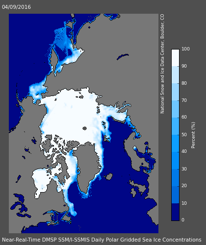
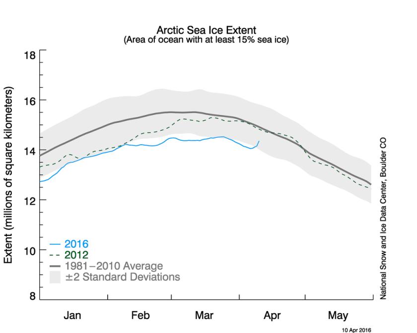
Look closely at the top centre of the image to see a large patch of spurious “sea ice”. Here’s the resulting SII extent graph from the NSIDC:
Anthony Watts reported this news in typically fanciful fashion:
There is this small notice on the NSIDC page:
“The daily sea ice extent images are currently displaying erroneous data. NSIDC is investigating.”
It looks to be a problem with the DMSP F17 satellite.
Makes you wonder how long this has been going on and if the anomalously low readings we’ve seen for awhile are due to a slow sensor degradation.
Time will tell.
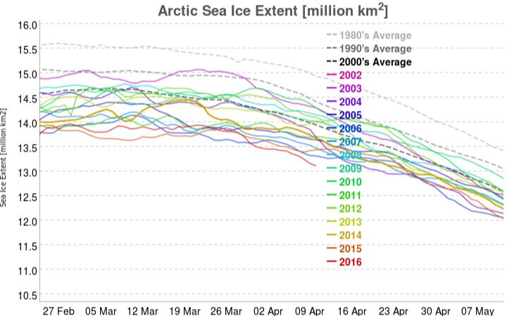
For a more realistic interpretation of the facts we suggest that instead of reading the propaganda perpetrated at WUWT you instead examine this graph derived using data from the AMSR2 sensor on board the Japanese SHIZUKU satellite:
Mr. Watts evidently takes a very US centric view of these matters, since he neglected to report this timely news bulletin from the OSI-SAF:
Due to the previously reported problems with one of the channels on SSMIS onboard DMSP F17, OSI SAF is now working on replacing DMSP F17 with DMSP F18 in our sea ice products.
Currently, the switch to F18 has been implemented for the ice concentration product (OSI-401). The product dated 20160410 has been reprocessed and is available on our FTP server, ftp://osisaf.met.no/prod/ice/conc/ and ftp://osisaf.met.no/archive/ice/conc/2016/04
The ice edge and type products (OSI-402 and OSI-403) will be updated to use F18 tomorrow, 2016-04-12.
It seems Willis Eschenbach, the current Watts Up With That resident sea ice expert, is already beavering away endeavouring to prove Anthony’s case for him:
We have no way to know if this has been a gradual decrease followed by a failure, so yes, it’s certainly possible that the previous data is bad. Doesn’t mean it is, but we’d be fools not to check.
We suggested a simple check:
Why not compare the NSIDC’s SSMIS data from F-17 with JAXA’s AMSR2 data from Shizuku? Wouldn’t that do the trick?
Willis replied:
I meant that just from the bad reading alone, we don’t know if the previous data is bad. Yes, we can check it in the way you suggest and other ways … which is why I said we’d be fools not to check.
We think that if he does his due diligence he will find that he is in actual fact engaged on a fool’s errand, but time will indeed tell. Let’s wait and see what Willis n Willard can come up with, shall we? Meanwhile we also cannot help but wonder what the dynamic duo might make of our own due diligence replicating the results of another collaboration of theirs:
It has been brought to our attention that some snow cover metrics have also been affected by the F17 “glitch”:
together with our alternative interpretation:
It would appear that the technical gremlins have migrated from DMSP F17 to WUWT?
Of course Watt’s has animosity towards Mosher, because in his warped view of reality Steven has gone over to the “dark” side. What I found hilarious is that Willard kept attacking Neven about neglecting to have a dedicated thread for the issue even though it was well covered at both the forum and blog. Isn’t that a little odd for a man whose blog has heard no mention of the recent “blowtorch” in the Arctic, deadly heat wave in India, hail larger than baseballs in Texas, as well as the droughts in Africa and Asia….nothing to see here. Wasn’t it Saul who tried in vain to bring the Greenland warning to the attention on the clueless Joe post at the end of March?
On a positive note we have learned that the mention of the ASIB and Neven get comments vanished…WUWT?
Professor Judith Curry seems to have become a trifle confused by the DMSP F17 SSMIS “glitch”:
Perhaps some more gremlins have descended to Planet Earth from outer space?
Wow, Jim, you’re seeing my comment. So, how do I get to that second comment page (tried changing the URL, didn’t work)? Not that I’m that interested in reading everything on WUWT, but someone was telling porky pies about what I had said earlier this week on the ASIB.
And, wow, that Judith Curry. Clueless (but strong wishful thinking)…
That arrived in my inbox Neven. I can’t see your comment at WUWT, or indeed the gremlin infested page 2. I can’t see my own most recent comment for that matter. Par for the course on the porky pie production line!
Once upon a time Judy used to write papers about the Arctic. That sounds like a fairy tale now though, does it not?
Neven,
One of my comments about one of your comments at WUWT has just magically appeared in my inbox:
I can’t find it anywhere over there though 🙁
The latest edition of the NSIDC’s Arctic Sea Ice News comments on the F-17 SSMIS problem:
It looks like JAXA’s AMSR2 is the go to source for the foreseeable future. Fortunately “Wipneus” has that angle well covered:
https://greatWhiteCon.info/resources/arctic-sea-ice-graphs/#ExtentRegions
The gremlin’s advanced alien technology have allowed them to transfer some of Snow White’s psychic powers to Prof. Curry. Here’s her predicted “strong comeback”:
Neven – It seems both our comments are still invisible at #WUWT this morning? That being the case, here is another screenshot from my inbox yesterday:
I have to admit that I often ask myself that same question. Here’s a screenshot from my “outbox” yesterday:
The #SnipGate scandal seems to be the gift that just keeps on giving?
If Willis and/or Willard are watching, here’s today’s version of just one example of Wipneus’ numerous comparisons between SSMIS and AMSR2 derived Arctic sea ice metrics:
It will be interesting to see how that one develops over the coming months, will it not?
It just got more painful with Watts putting up a guest blog by some guy claiming that global sea ice is making a remarkable comeback. The recovery has begun, just a day or two after Watts announces the important discovery of a failing satellite sensor. 😐
I think I’m going to pass on this one.
I’ll pop over there to peruse the porky pies at least. Thanks for the heads up.
Calling Mr. Watts (even accurately!) out on it is a good way of getting on his permanent black list. Join the club! Maybe this will ease the pain somewhat?
Having taken Neven’s hint and glanced at WUWT again I discover that Willard is now promoting the self same nonsense as Judy Curry (see the “Tweet” above). We started to deconstruct Willis Eschenbach’s HadISST antics only a couple of days ago:
The Awful Terrible Horrible Arctic Sea Ice Crisis
It’s looks as though we’ll now have to redouble our efforts! Feel free to assist us by following the link then scrolling down to take our Arctic sea ice Rorschach test.
Bob Grumbine has been (successfully!) commenting at WUWT, but seems to be suffering under a misapprehension about some of the satellites discussed above. Here’s my so far vain attempt to straighten things out:
A packet of peanuts to the first person who spots my comment in the wild over at Watts Up With That!
In the continuing absence of plausible data from Cryosphere Today, here’s a couple of “regional” area plots:
Between a rock and a hard place…
DMI have just announced that their extent graph is back online and up to date:
Here is is:
It looks to me like it’s still the lowest for the date, in recent history at least.
An update from NSIDC. It seems that DMSP F-17 SSMIS is working again!
That’s great news! Definitely worth blogging about now (I don’t have the time, busy with another blog post, but I’ll mention it). 😉
Maybe Willard will post about it since he seemed to be so concerned about this issue last week but I wouldn’t hold my breath waiting…
Commenter “Phil” has now posted a comment to that effect at WUWT. Perhaps it will be turned into a “guest post”?
For some strange reason my inbox contains news of several comments from “Saul” on the problem, not one of which are actually visible on Mr. Watts blog!
https://archive.is/mMq5h
Are you sure you are looking at the right thread?
Now that you come to mention it I’m quite sure I was looking at the wrong thread!
In my defence one could conceivably argue that Saul should logically have commented on the most recent thread on the topic. Be that as it may, Mr. Watts has evidently no conceivable excuse for not singing the praises of solar panel realignment to the rafters of his hallowed halls.
Fiddles while dome burns…
You may get a smile if you reread the beginning of the thread I linked…To me it is obvious why he stayed on that thread. Willard and clueless Joe Bastardi certainly came out the losers in that exchange.
What I find curious is the conspicuous absence of dbs when Saul is posting.
So, did DMI and Arctic-ROOS switch to something else (F19)? And if so, will they switch back now?
DMI didn’t reply to my Tweet, so I can’t be sure whether they moved to F-18 (F-19 is dead already!) or reverted to the newly restored F-17.
However OSI-SAF definitely said they had switched to F-18 (see above), and OSI-SAF is where DMI say they get their numbers from. So all in all, at the moment I don’t know!
Non Prof. Watts evidently doesn’t check the NSIDC web site very often, or indeed the comments on his very own blog for that matter. Apart from Phil & Saul’s comments regarding F-17’s miraculous recovery I sent him this virtual postcard this morning (UTC):
Undeterred by mere facts, Willard claimed this evening (EST) that:
I sent him this by return:
That information is needless to say also currently still invisible to the denizens at WUWT.
Willard says:
“Neven, you and your two hater friends at that other sea ice blog seem to hell-bent on complaining I missed this”
Hater friends?
He did miss it!
Anthony seems happy to admit that he’s censoring my many helpful comments on his blog:
However I’m afraid he will have to do a lot better than “hater friends” if he wants to claim the Great White Con “New Einstein” award this year. In the meantime he is currently claiming:
Have I got news for you Anthony. Here’s a more ancient screencap:
and here’s a more recent one:
Here’s my most recent helpful missive to the denizens of Watts Up With That:
I wonder what time Anthony wakes up in the morning?
Anthony is awake, and doing a very good impersonation of somebody who doesn’t have a clue:
Here’s a clue from the NSIDC for you Anthony:
The latest news release from the NSIDC reveals that they:
The reason for the delay is that:
The NOAA@NSIDC team suggest that:
Having recently discussed the pros and cons of MASIE with Walt Meier of NASA we’ll stick with metrics derived from JAXA’s AMSR2 numbers here at Great White Con. This is how they look at the moment.
Another news release from the NSIDC today:
Daily sea ice extent updates resume with provisional data
BT over Ellesmere Island finally expired…going to miss all those cloudless MODIS images.