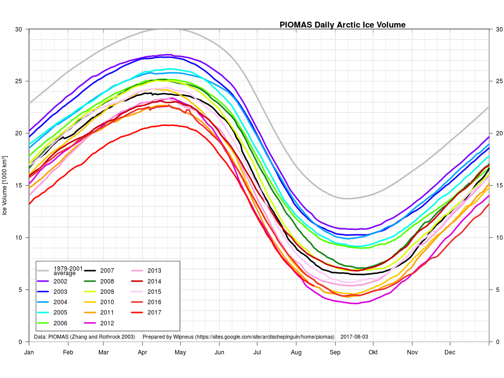
What seems likely to be the most interesting period of the 2017 Arctic sea ice melting season is upon us! The PIOMAS gridded data hasn’t been released yet, but the overall volume numbers reveal that 2017 has now relinquished its “lowest ever” position to 2012. Here’s Wipneus’ graph of the volume data:
plus his anomaly plot:
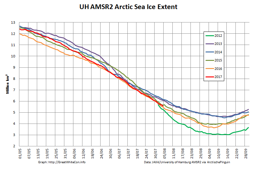
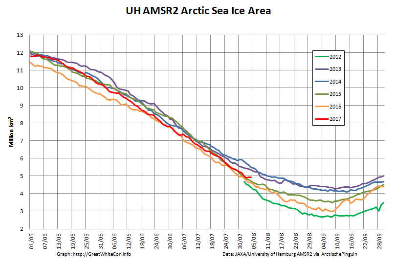
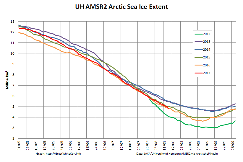
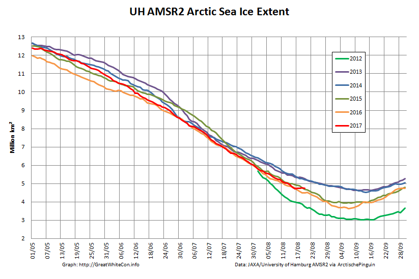
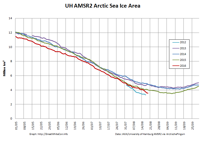
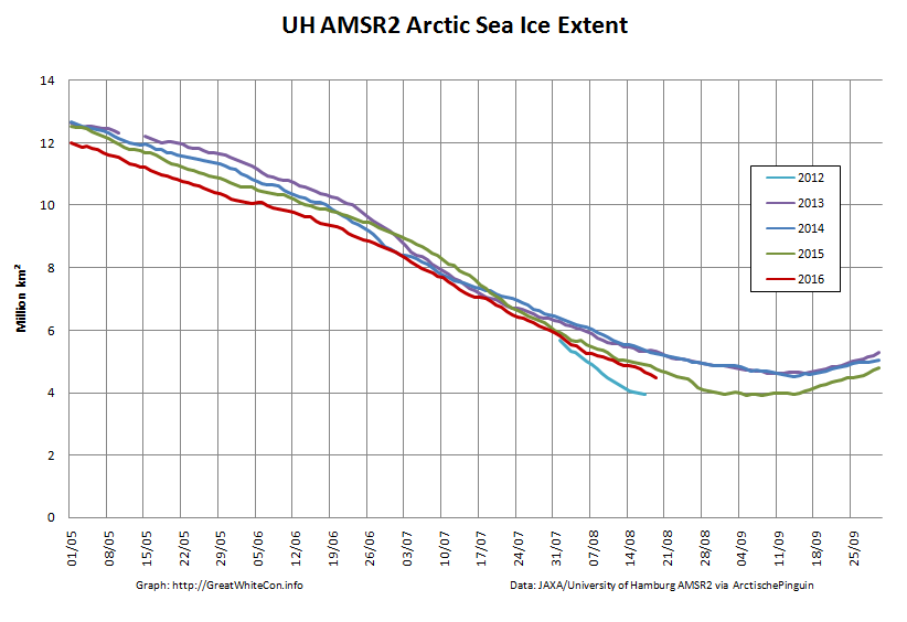
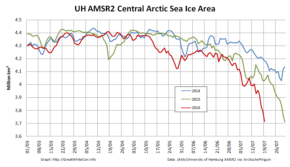
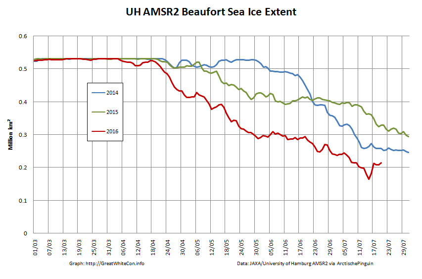
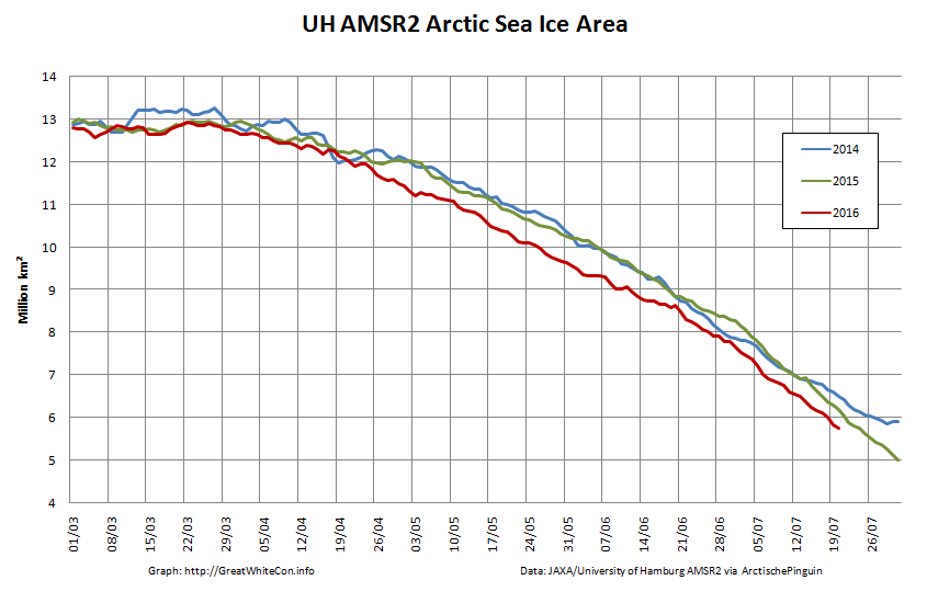
Our favourite high resolution AMSR2 area and extent graphs now also allow comparison with 2012. Here’s how they look at the moment:
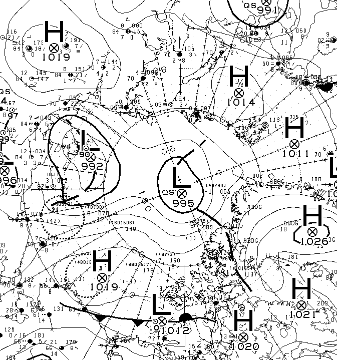
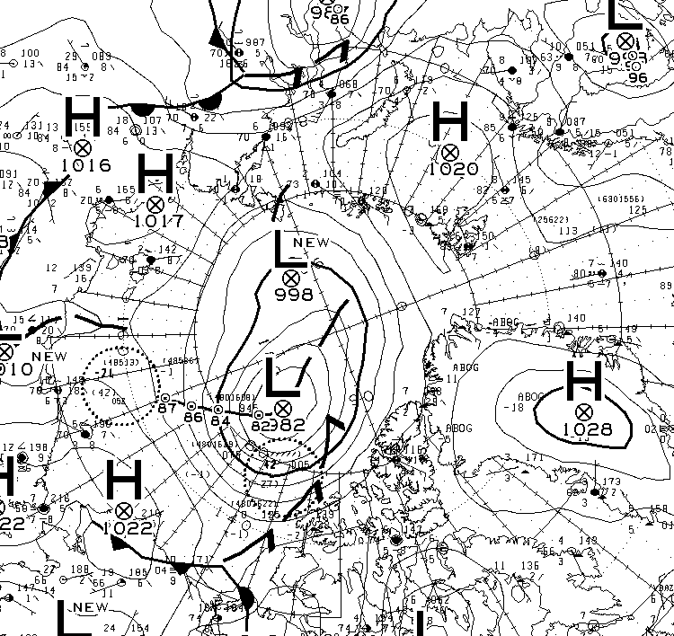
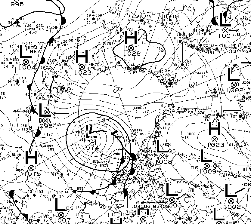
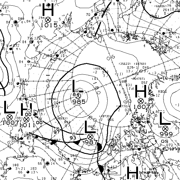
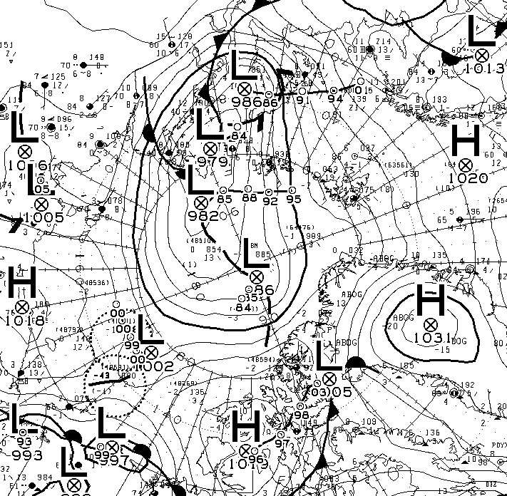
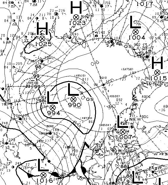
As you can see, round about now is when 2012 Arctic sea ice extent started to noticeably race ahead of the rest of the pack. Will 2017 follow suit? Are there any Arctic cyclones on the horizon for example? Well, the one forecast for August 4th hasn’t materialised. Here’s this morning’s Environment Canada synopsis:
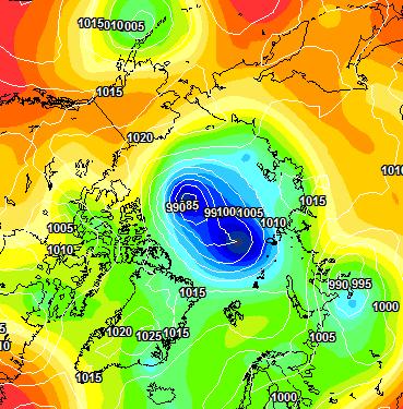
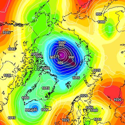
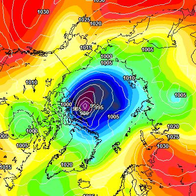
However both ECMWF and GFS agree that a sub 985 hPa storm should have arrived by Sunday morning. Here’s the ECMWF version from MeteoCiel:
There’s stronger storms in the forecast further out, but once again we’ll believe them if and when we see them!
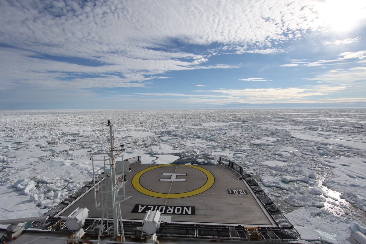
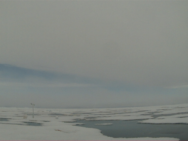
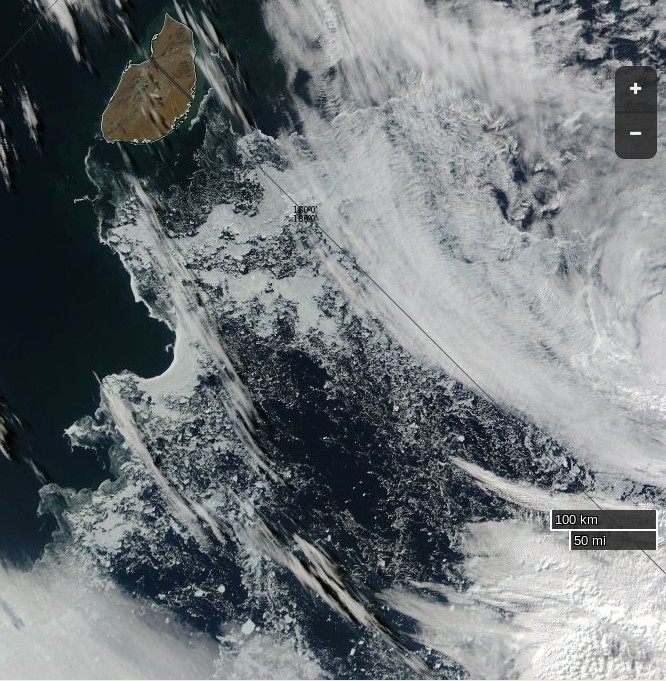
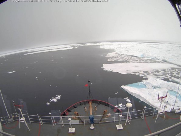
We’re keeping a close eye on the Northwest Passage once again this year. Most of the southern route is open already, but as we predicted the old ice in Larsen Sound has a lot of melting still to do. Here’s how it looked from the icebreaker Nordica a few days ago:
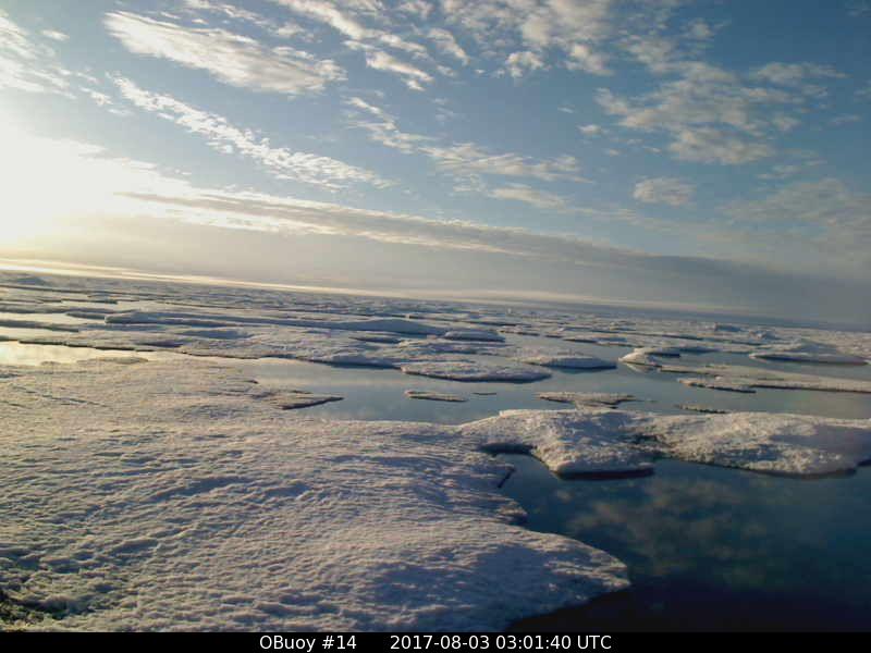
On top of that the old ice around O-Buoy 14 is currently rushing south down the McClintock Channel to replenish it. Here’s how that looks at the moment:
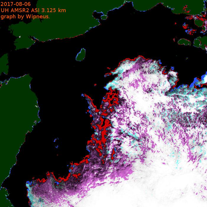
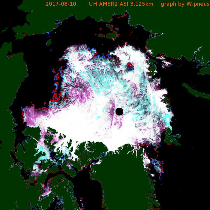
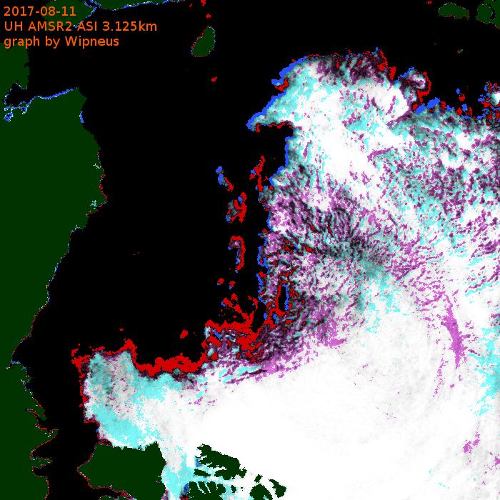
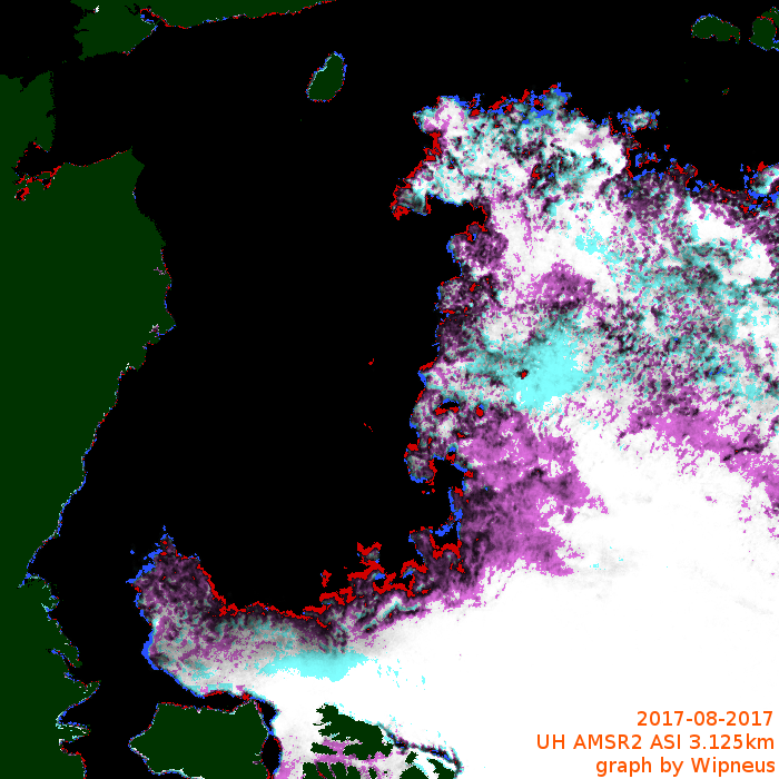
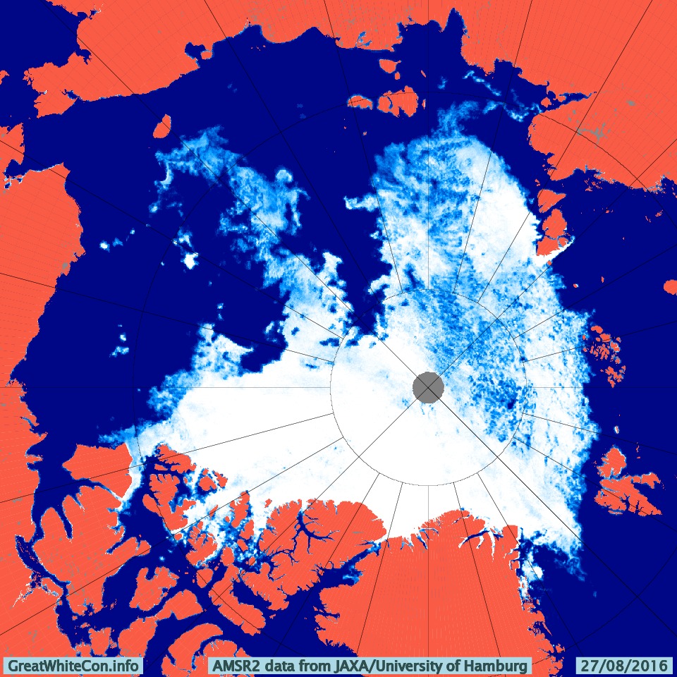
Meanwhile the melt along the Northern Sea Route is well ahead of last year. Here’s the University of Hamburg AMSR2 concentration map of the area:
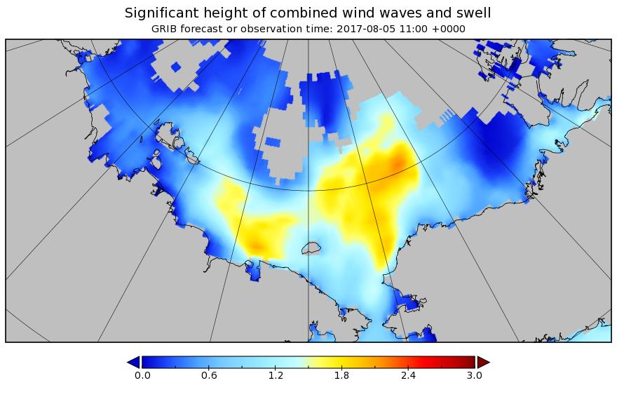
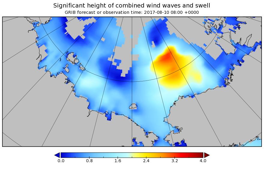
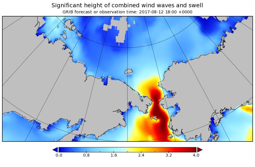
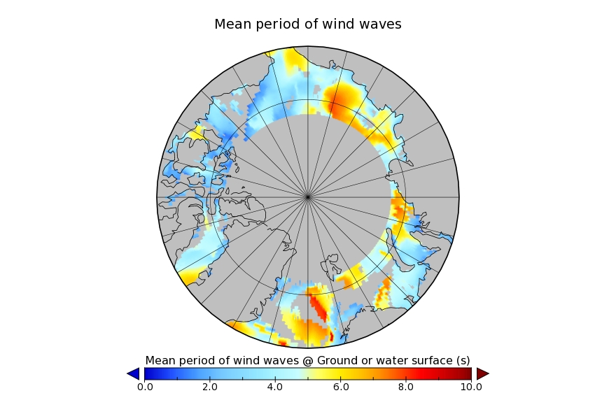
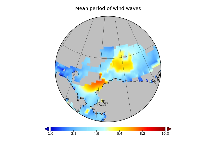
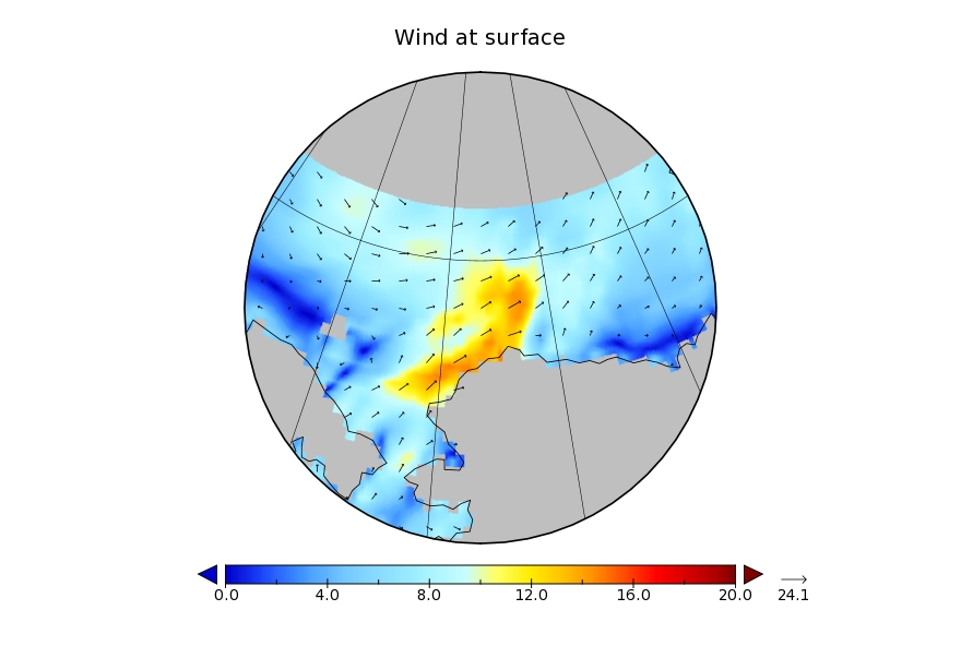
There’s also now a lot of open water on the Pacific side of the Arctic, and Sunday’s cyclone is forecast to create a large area of 2 meter plus waves heading in the direction of the ice edge:
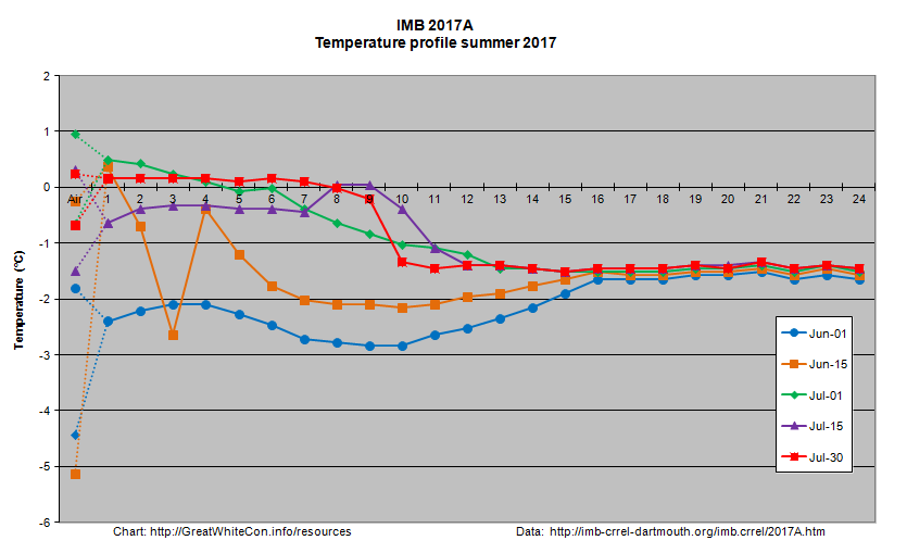
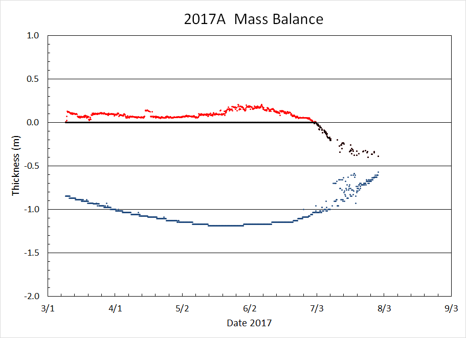
I expect that to have a noticeable effect on the already fragile sea ice by early next week, assuming the storm arrives as forecast! There is an ice mass balance buoy handily placed out on the ice in the path of the storm. Buoy 2017A is currently located near 77 N, 147 W, and its assorted sensors suggest the ice underneath it is now less than 20 cm thick:
Here’s how the area around the buoy looked a couple of weeks ago:
Image of 2017A from WARM 6 on July 18th 2017. NSF project: NSF OPP #1603548
The $64,000 question now is will the 2017 Arctic sea ice metrics stay in amongst the recent pack, or race after 2012 instead?
[Edit – August 6th]
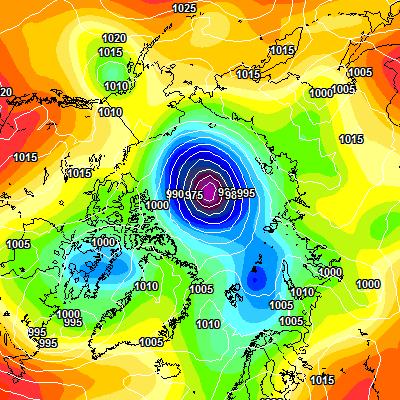
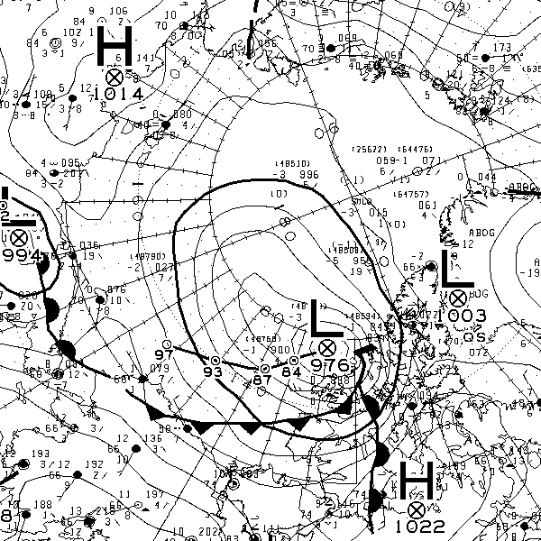
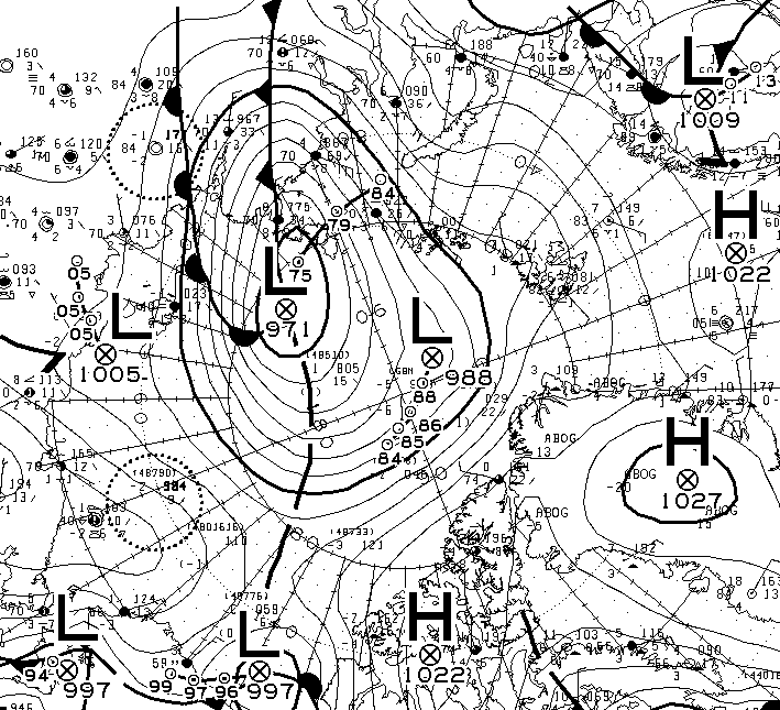
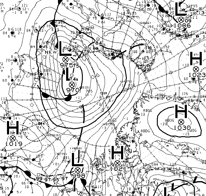
This morning’s synopsis from Environment Canada suggests the cyclone has bottomed out at a MSLP of 982 hPa:
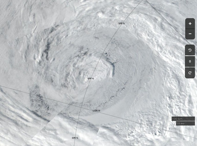
Here’s how the cyclone looked from space yesterday:
NASA Worldview “true-color” image of the sea ice north of the Beaufort Sea on August 5th 2017, derived from the VIIRS sensor on the Suomi satellite
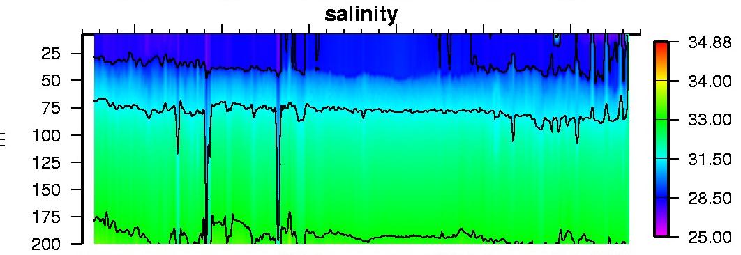
I think that I can convince myself that the salinity profile from ice tethered profiler 97, currently located at 73° N, 134° W, reveals mixing from depth in the wake of the storm:
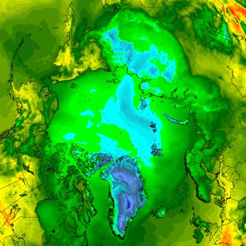
The synthetic aperture radar on the Sentinel 1B satellite can certainly see through the clouds, and reveals open water in the Central Arctic north of the Beaufort Sea yesterday evening (UTC):
Sentinel 1B image of Arctic sea ice at 79° N, 160° W on August 5th 2017
The effects of this weekend’s storm are readily apparent! Just in case you’re wondering Wipneus reports:
Area: -172.0 (+324k vs 2016, +138k vs 2015, -669k vs 2014, -523k vs 2013, +493k vs 2012)
[Edit – August 8th]
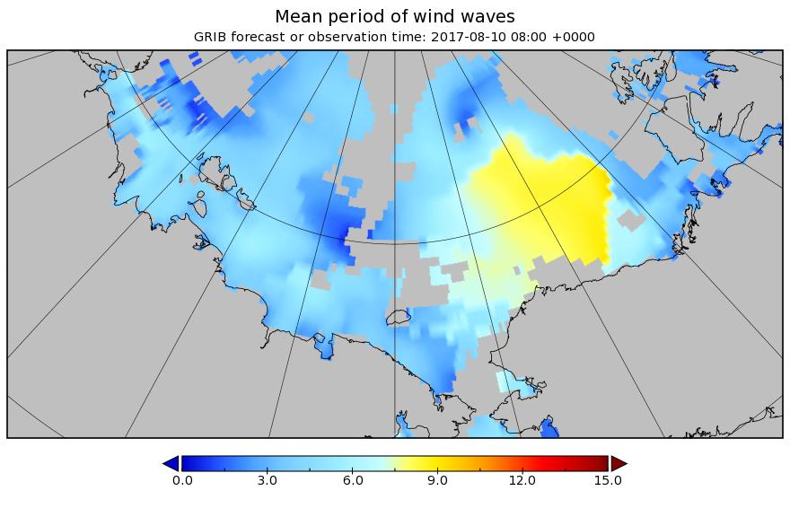
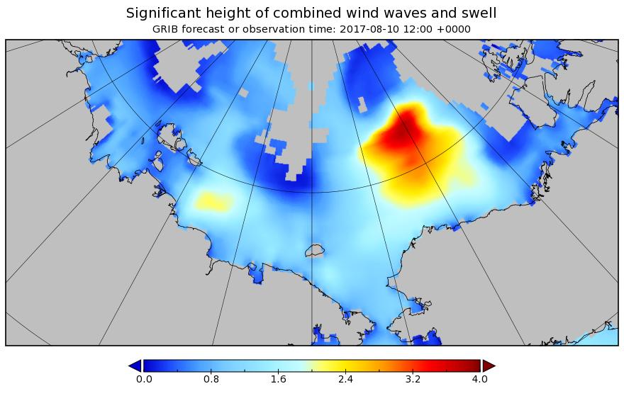
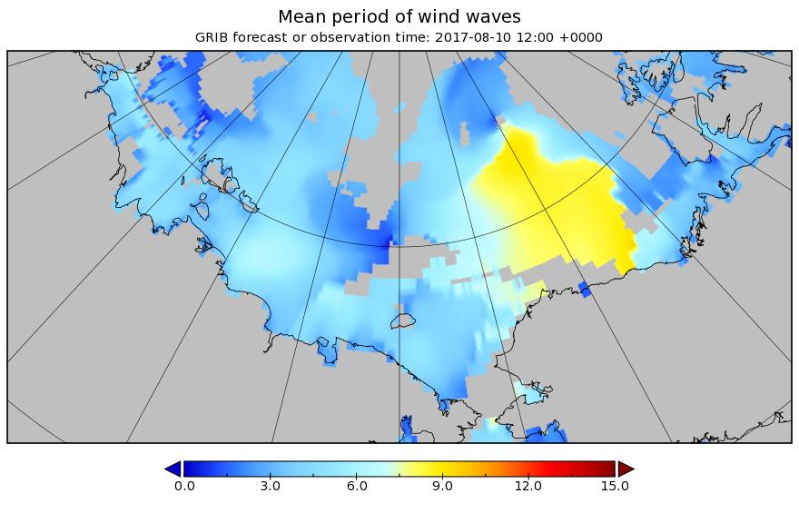
The next pulse of swell is currently forecast to be somewhat higher and longer period than the last one. This one is also taking aim at the Beaufort Sea MIZ:
[Edit – August 9th]
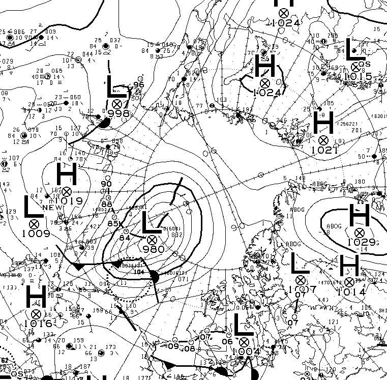
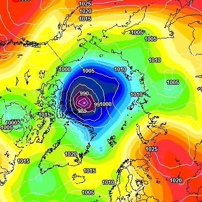
According to Environment Canada the latest cyclone is already down to 980 hPa MSLP:
[Edit – August 9th PM]
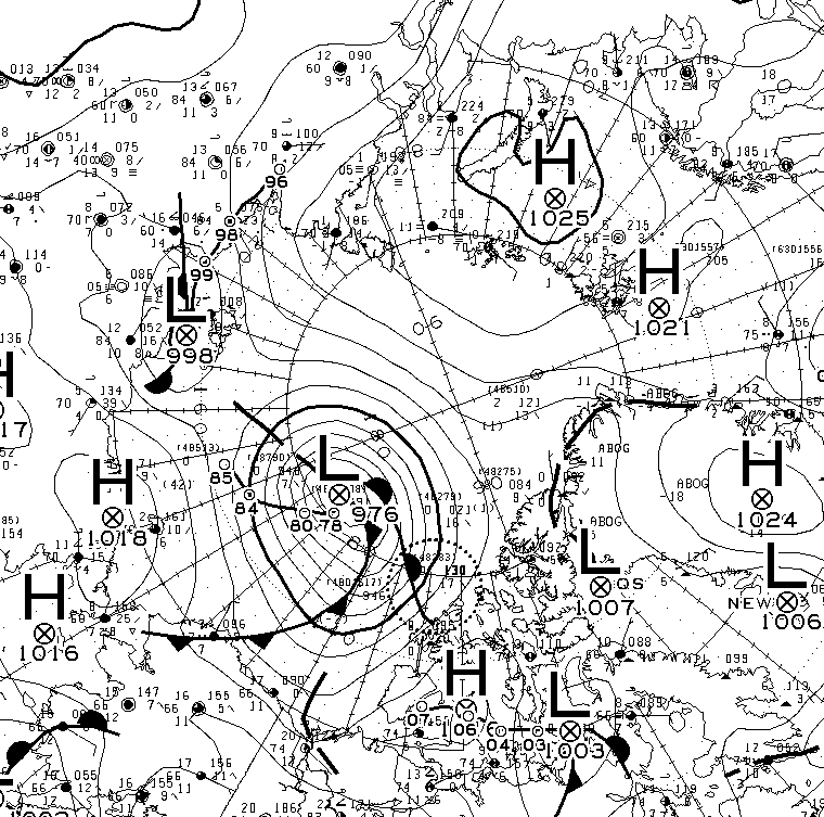
The MSLP of the current cyclone is now down to 976 hPA:
The latest WaveWatch III forecast has increased the predicted peak height and period of the resulting waves once again:
[Edit – August 10th]
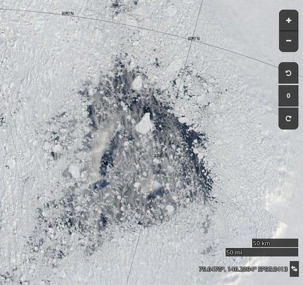
Large holes are appearing in the sea ice on the other side of the Arctic too. Take a look north of the Laptev Sea for example:
NASA Worldview “true-color” image of the “Laptev Bite” polynya on August 10th 2017
Meanwhile the current cyclone on the Pacific side of the North Pole appears to have bottomed out at 974 hPa:
[Edit – August 11th]
Here’s the latest sea ice concentration one day delta map from Wipneus:
Despite the expected divergence caused by a low pressure area crossing the ice, both are and extent of sea ice on the Pacific side of the Arctic are still falling.
[Edit – August 12th]
The waves are considerably smaller in the Beaufort Sea today, but not in the Bering Strait!
Here’s the latest one day delta map:
and here’s video showing the motion of sea ice in the Beaufort & Chukchi Seas so far this summer:
[Edit – August 13th]
Here’s an animation from Wipneus revealing the effect of the two recent cyclones on the Pacific side, plus everything else that’s been going on in the Arctic:
Click the image to see a much larger (3.3 Mb) version.
[Edit – August 16th]
AMSR2 Arctic sea ice extent has taken another tumble, and has dropped below 2016:
Only 2012 left to beat!
[Edit – August 18th]
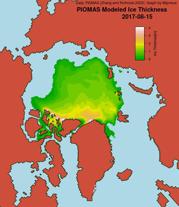
A PIOMAS mid month update has been released, including gridded thickness data. 2017 modelled volume has failed to follow 2012’s trajectory towards the September minimum, and is now on a par with 2011:
[Edit – August 21st]
After a “brief hiatus” in the wake of the recent cyclones Arctic sea ice area has posted a new low for the year:
Extent has yet to follow suit:
The main loss of area has been in the “Beaufort Bite” once again:
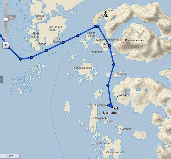
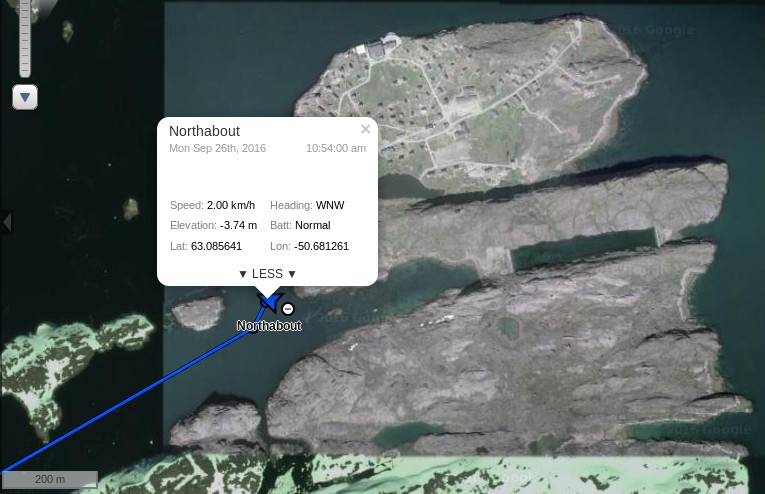
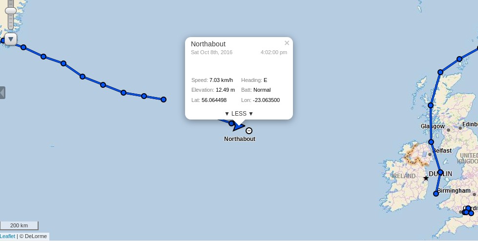
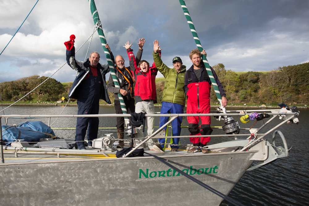
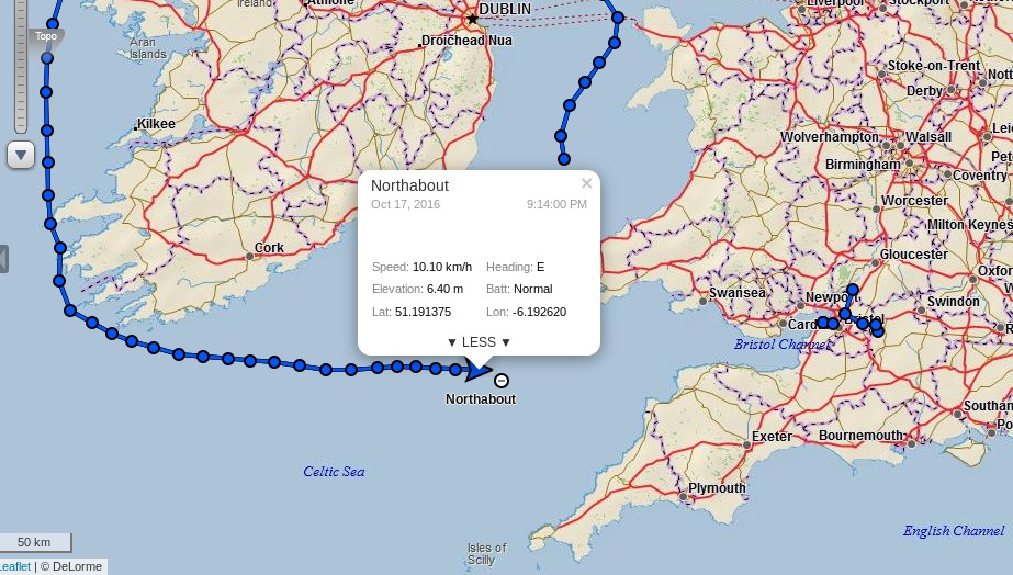
Following another crew change the Polar Ocean Challenge team in their yacht Northabout have just left Nuuk in Greenland, bound for Bristol in South West England:
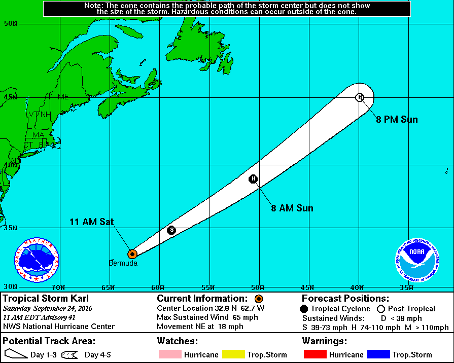
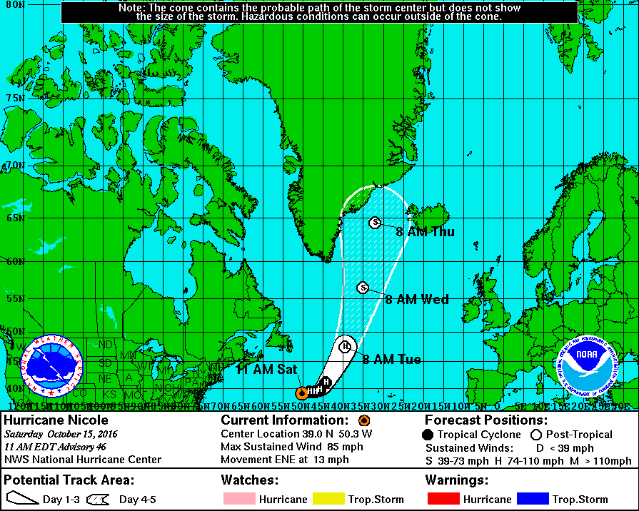
To get back to good old Blighty they are going to have to brave the North Atlantic in Autumn. Some stormy weather is likely! We’re currently keeping an eye on Tropical Storm Karl, who has just left Bermuda in his wake and is forecast to reach hurricane strength before heading off across the North Atlantic:
The latest advisory bulletin from the National Hurricane Center forecasts that:
Karl is forecast to be absorbed by an extratropical cyclone early Monday.
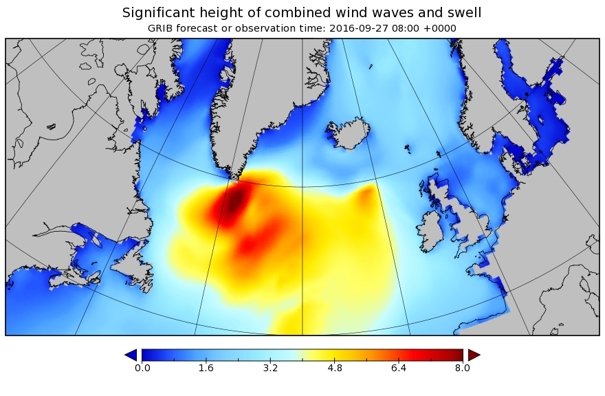
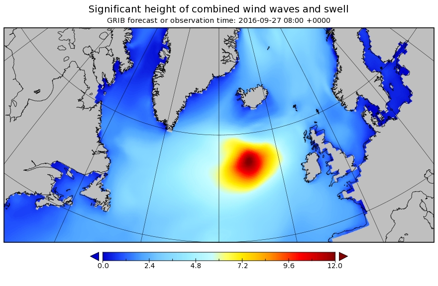
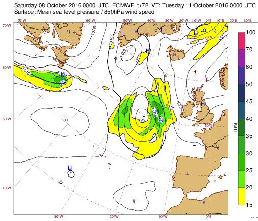
That cyclone looks set to create 8 meter waves south of Greenland! Here’s how the significant wave height forecast looks for 08:00 on Tuesday September 27th:
What happens after that remains to be seen. We will keep you posted!
[Edit – September 25th]
The new captain of Northabout, Mike Stewart, reports that:
We have decided to approach things in a relaxed manner, and for the first few days, at least, we will day sail southwards amongst the islets and channels towards our departure point, in a sort of ‘shake down’ period, to get used to each other and our vessel, we will head for a remote weather station on the very south east tip of this vast and forbidding Island. More to say on that later..
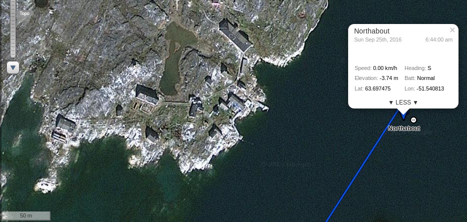
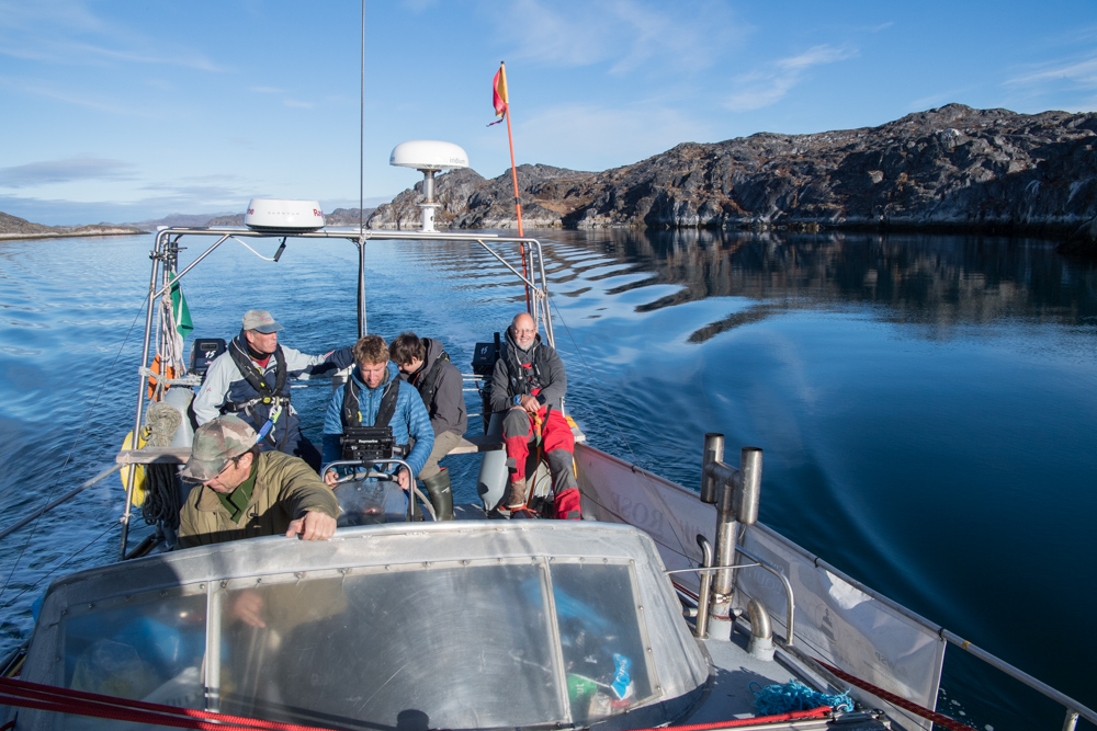
Our home for this, our first night, as a complete crew is at anchor next to a tiny abandoned port named FAERINGEHAVN. Old dead wooden whalers, ribs now showing, and sad broken down port buildings, minus roofs, are our view of the shore less that 50m away. Have a close look at the top of this image, or zoom in on the tracking on the satellite view.
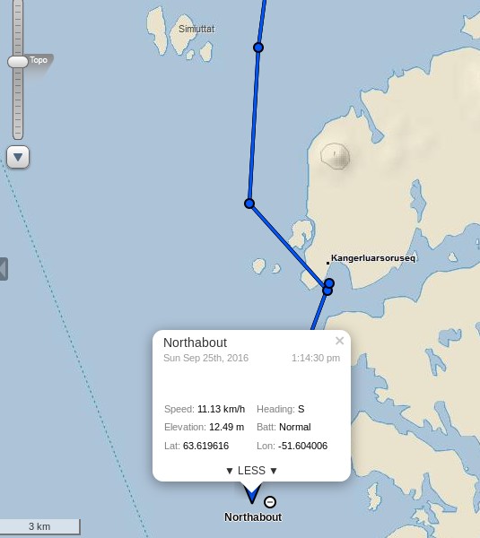
We did just that:
which reveals that the new name for Færingehavn is Kangerluarsoruseq.
Mike also points out that they are not alone:
We have visitors! EAGLES QUEST II crew, (a Hong Kong registered Tayana 58 who have sailed from via Alaska), decided to tag along for a while are on their way over for a brew..
Given the storm that Karl is brewing up in their path a leisurely cruise to Cape Farewell seems like an eminently sensible idea to me!
[Edit – September 25th PM]
Northabout has now set off on the next section of her island hopping cruise to Cape Farewell:
[Edit – September 26th]
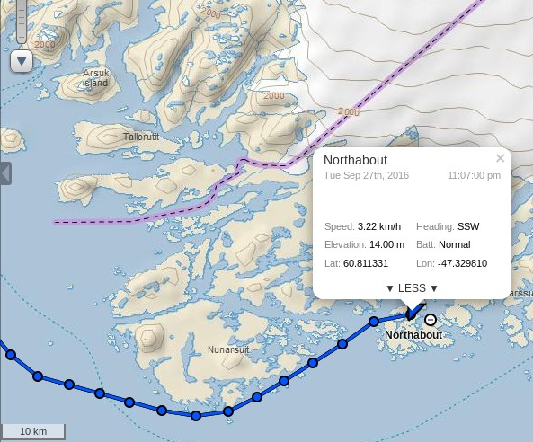
Northabout anchored for the night near Fiskenæsset (AKA Qeqertarsuatsiaat):
She has just set off hopping amongst a few more of the numerous islands off the south-west coast of Greenland:
The imminent storm swell is now forecast further out into the North Atlantic than two days ago, but has grown to a predicted 12 meters:
Note the change in scale!
[Edit – September 27th]
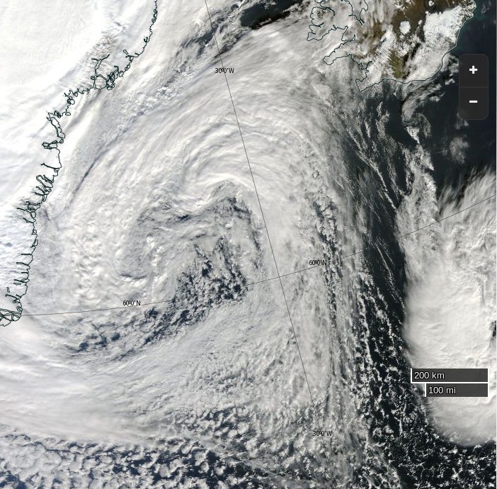
Here’s the storm currently raging in the North Atlantic:
NASA Worldview “true-color” image of the North Atlantic on September 27th 2016, derived from the MODIS sensor on the Aqua satellite
Northabout looks to have found a sheltered spot to stay the night:
It seems that her new crew have experienced plenty of fine weather recently. According to Ben Edwards:
This is ridiculous. Three days in a row and we’ve had the best weather of the entire trip. We woke up in the morning to relative warmth and clear skies our trip ashore to Qeqertarsuatsiaat was short but pleasant with a trip inside the local church.
Upon our return to Northabout we got the anchors up and motored off. We managed to get the sails up a couple of hours later and we’re now doing about eight knots. We passed a glacier earlier on which was a little odd. From where we sat it seemed huge. The head alone was several miles across. The strange thing was that it didn‘t seem to stretch down to the coast. We were fairly sure of this because we could see a line of what looked like stone between the ice and the water and there were no icebergs that we could see. If it was at the water one would expect bits to break off and form bergs. … So it seems likely that it never reached the coast.
Let’s hope that continues!
[Edit – September 30th]
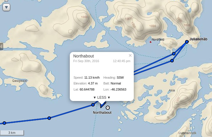
Northabout has just departed from Qaqortoq (AKA Julianehåb):
The Polar Ocean Challenge team have released a beautiful video of one of their recent sheltered spots to stay the night:
On their blog the current captain of Northabout, Mike Stewart, said yesterday:
We have successfully disembarked Steve and continued our preparation of Northabout for crossing the Atlantic. We have also re-fueled in situ courtesy of the Qaqortoq fuel supply truck, and have fitted a new house battery to bolster the hard working but a bit tired battery bank in place. This will keep our domestic amp draw supported- chart plotter, nav lights, interior lighting, electric pumps and bilge pumps etc working as they should. This also ensures that the engine start battery is kept fresh for its most important job.
I am told by the Inuit lady in the local chandlery that its going to blow hard tomorrow. We should have the wind behind us for our transit to the east, and then if all is ok run in to shelter mid afternoon.
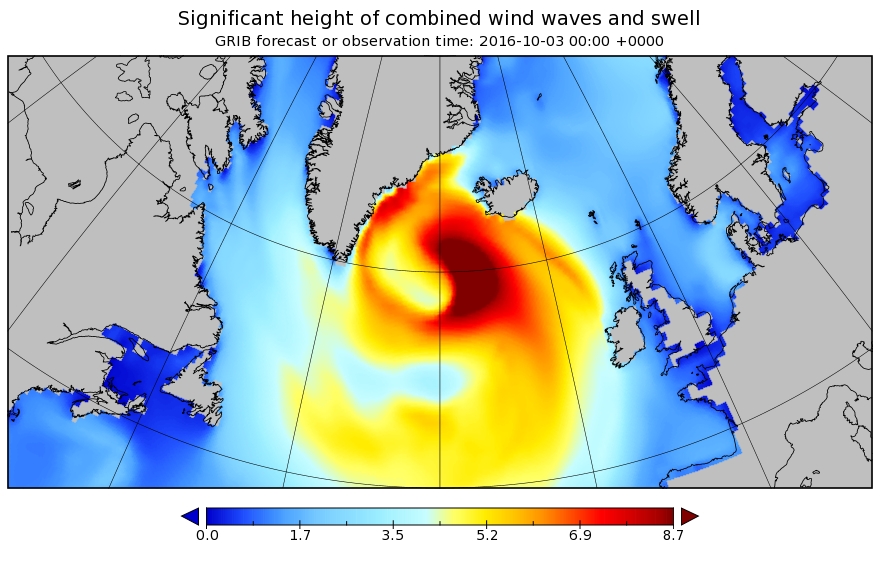
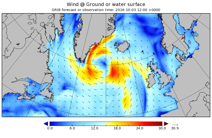
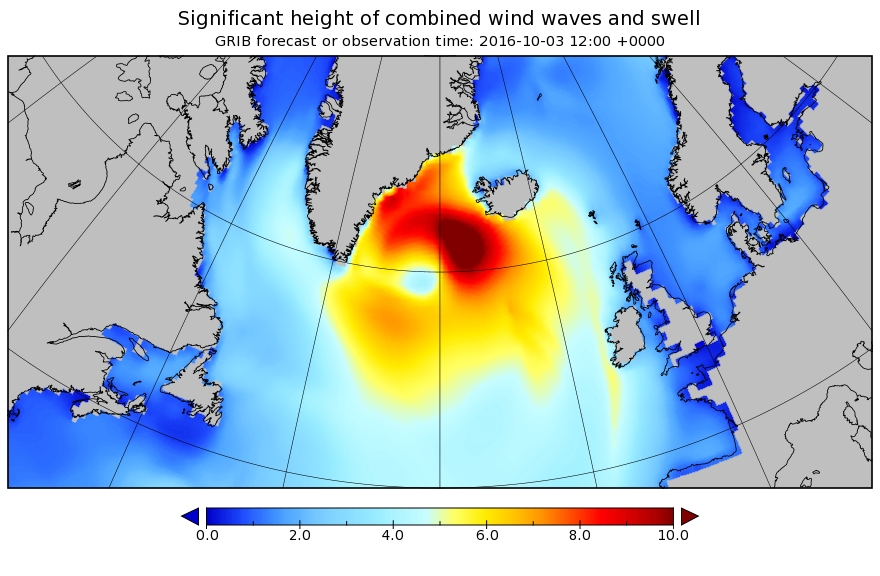
In actual fact it looks like it’s going to blow even harder in the not too distant future. Here is our North Atlantic “surf forecast” for 00:00 UTC on Monday October 3rd 2016:
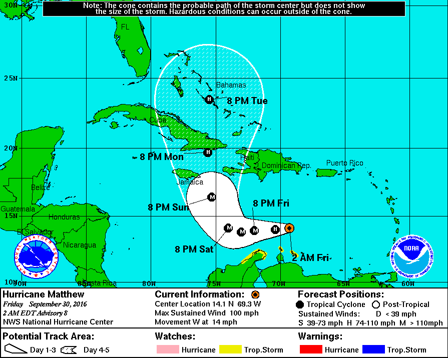
Meanwhile much further south in the Caribbean, Hurricane Matthew is forecast to become a major hurricane before reaching Cuba and then heading north across the Atlantic Ocean:
[Edit – October 1st]
Northabout is on the move again:
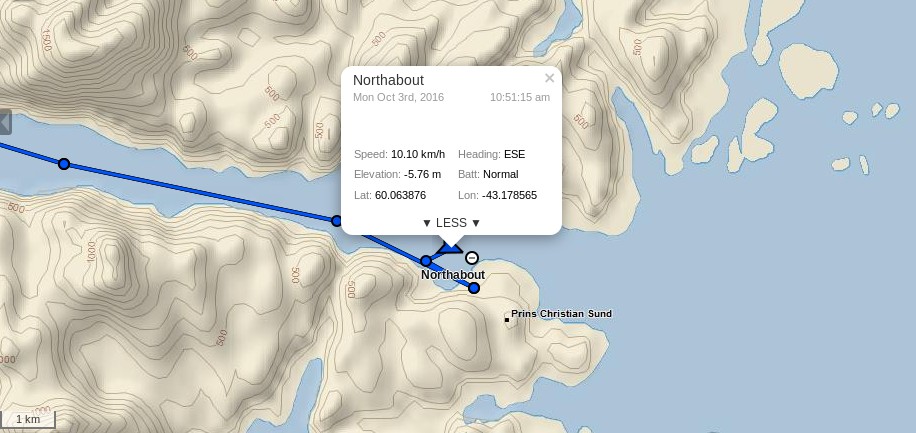
It seems my assumption that she would round Cape Farewell early next week was mistaken. According to Mike Stewart:
The strategy is to reach our departure point on the eastern entrance to PRINCE CHRISTIAN SOUND, which has a conveniently manned weather station and pier, in about two days sailing. This will allow us to hold in a safe area, whatever the weather in the Atlantic, and be in an ideal location to depart immediately to sea when the storm that is dominating the north Atlantic abates. After crossing Biscay 4 times this year, I have learnt that after a blow, kind of ‘riding on the back of it’ is an ideal time to head off. I recall something about the Chinese ideogram for chaos and opportunity being the same written character.. and as we have 3 Chinese sailors around half a mile behind us right now, I’ll use that to describe the general strategy I have in mind. Actually looks good for a Tuesday pm departure into decaying westerlies around 30-35 KTS.
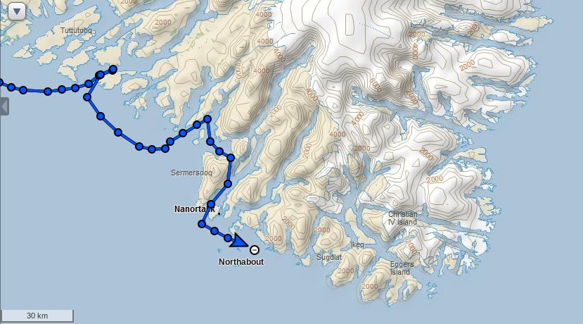
If you look at the map above the planned route will take Northabout through the islands of Southern Greenland, passing to the north of Christian IV Island.
She is now heading in the direction of the Irminger Sea:
Beyond that the wilds of the North Atlantic beckon, where there is still a fair old storm raging!
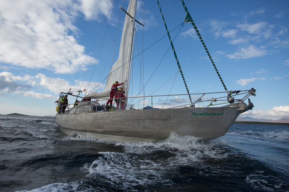
It looks as though the Polar Ocean Challenge team are hoping to get a good head start on their voyage back to Bristol from the strong winds in the wake of that storm, but there’s also some big waves to contend with:
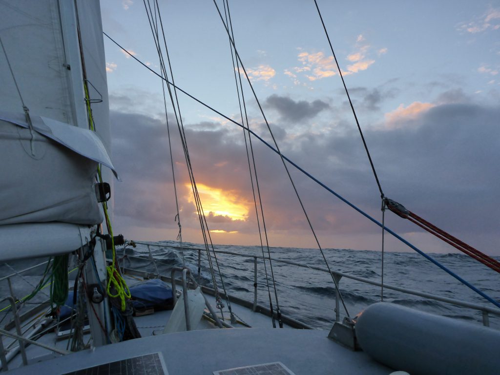
Differing accounts from Northabout in the stormy North Atlantic today! Skipper Mike Stewart reports that:
There is another low that will affect us in the next 24 hours, this will be through by tomorrow midnight, and most of its associated wind is westerly or northerly in our bit, anyway we take what we get here, its as simple as that. We have handled this at 50 KT with around 7m seas, (occasionally 8-9m) so our confidence levels are good. I heaved the boat to for a few minutes to test how she behaved, and she was ‘OK’ sitting duck like as the rollers powered through beneath us. During the evening, we were hit by one breaker, as always, theres a set bigger than the rest, and of course one broke over the boat, we were lifted and pushed sideways like a cork, but did not go over to any degree, which says volumes for our stability curve.
My first watch was from 1400 to 1600, and was quite an experience. I attached my harness before leaving the main cabin – I leave it permanently attached in the cockpit, a tip from a recent letter in Yachting Monthly – attached the second hook to another point near the wheel, and then took over from David. Looking around at the conditions a loud “Yeehaaar!” left my mouth and was whipped away by the wind. The seas were magnificent, lashed by the wind and spewing spume from the top, as Northabout gamely reached across the tops under reefed staysail.
So the night hath passed and we’re still alive. To me it feels like it was a bit of a close run thing…
I did my watch (eight to ten) and went straight to bed, not that that saved me. Twenty minutes later I rushed to the toilet and threw up my breakfast of porridge and tea. I then went back to bed, the swell got larger, the wind got stronger, I went back to toilet. This continued for the next ten hours. In total I threw up six times, a personal best.
Tomorrow is another day!
[Edit – October 8th]
David Wynne Davies reports from the middle of the North Atlantic:
Half way point to Ireland reached yesterday. Progress had been impeded by headwinds but with the wind now backed to the South and on the beam we were making 7kts. In order to catch up lost time the mainsail as well as the genoa were hoisted supported by the engine although increasing winds this afternoon (gusting 50kts squalls) prompted us to reduce to 3 reefs and a reduced staysail.
Everything then was cracking on beautifully in fairly rough seas – until the engine splutters and dies. Mike switched fuel tanks in the belief that the forward port tank may have been contaminated or be getting close to having to be switched over. Engine starts, but again stops suddenly. After further consideration the starboard fuel tanks were tested, and the engine started to run smoothly again. We will have to figure out why the port fuel tanks are not feeding through.
Last night to conserve fuel we stayed under sail started off making 5.5 kts. The wind is expected to ease over the next few days, and helpfully be on the nose when we cross the St George’s Channel. Let’s hope that the high pressure over UK moves away before then and that we can benefit from Westerlies.
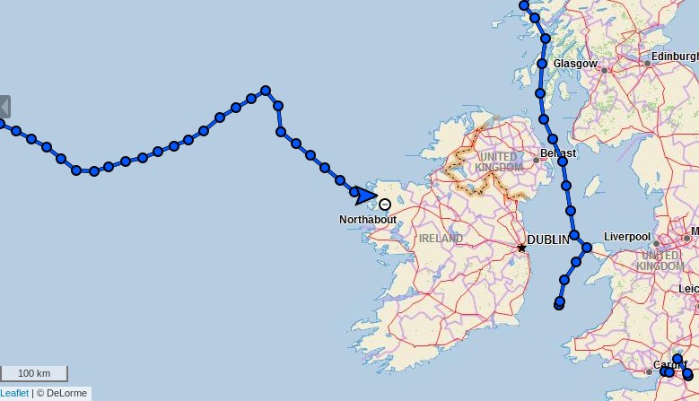
Possibly related to the spluttering engine, Northabout’s live tracking ceased to function for a while yesterday:
After an anxious wait it burst back into life, and confirms Northabout’s steady progress towards a welcome pint of Guinness in Ireland:
Here’s the ECMWF MSLP forecast for Tuesday morning revealing the approach of another low pressure system, which Northabout is no doubt hoping to avoid as far as possible:
[Edit – October 12th]
After a major, weather enforced detour:
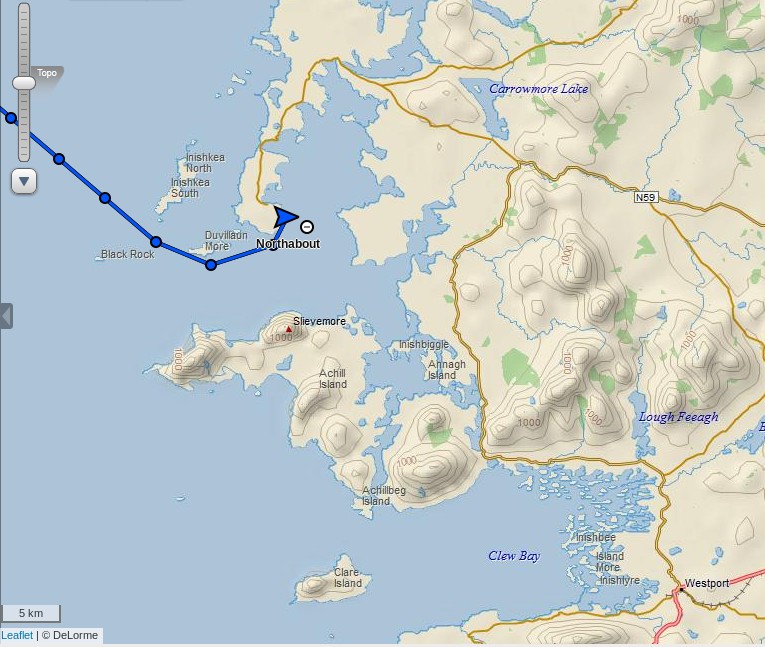
Northabout has just reached Ireland! After a recent blog post mentioned the town I thought they were heading for Clew Bay and Westport:
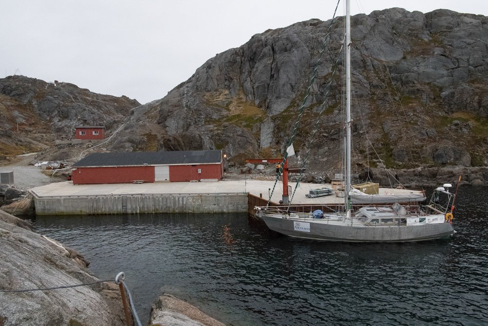
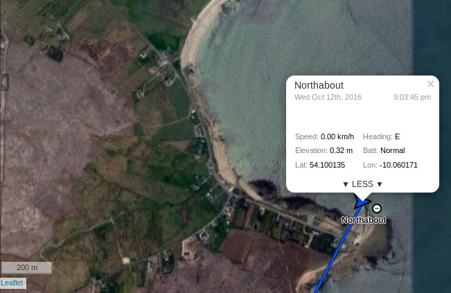
However they have stopped for the night north of there, at Blacksod Bay:
I hope there’s a hostelry available to serve the crew their longed for pints of Guinness. Then it’s on to Westport tomorrow.
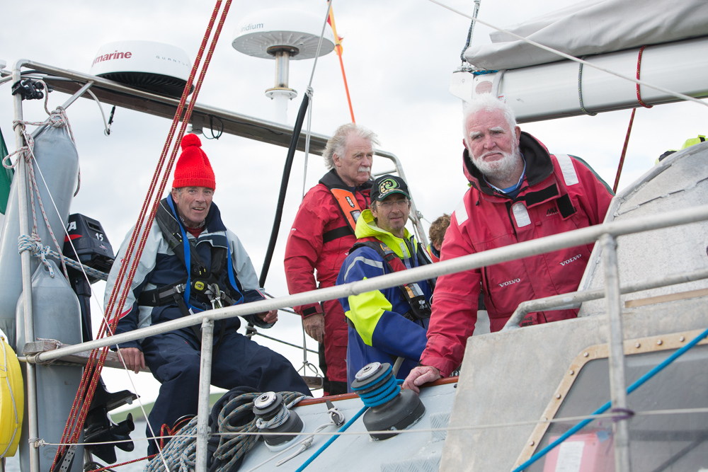
We arrived at Blacksod in darkness on Thursday evening to an unforgettable welcome from Jarlath, Mike, Tom and Mr Sweeney (the lighthouse keeper). Frances Gard was there too having hitched a lift after her Ryanair flight from Bristol.
With great enthusiasm they took our lines and promptly escorted us to a local hostelry. By golly, Guinness is indeed good for you at times like that! In true style, out came the fiddle and accordion with songs about Lord Franklin and other maritime disasters (all uplifting stuff!).
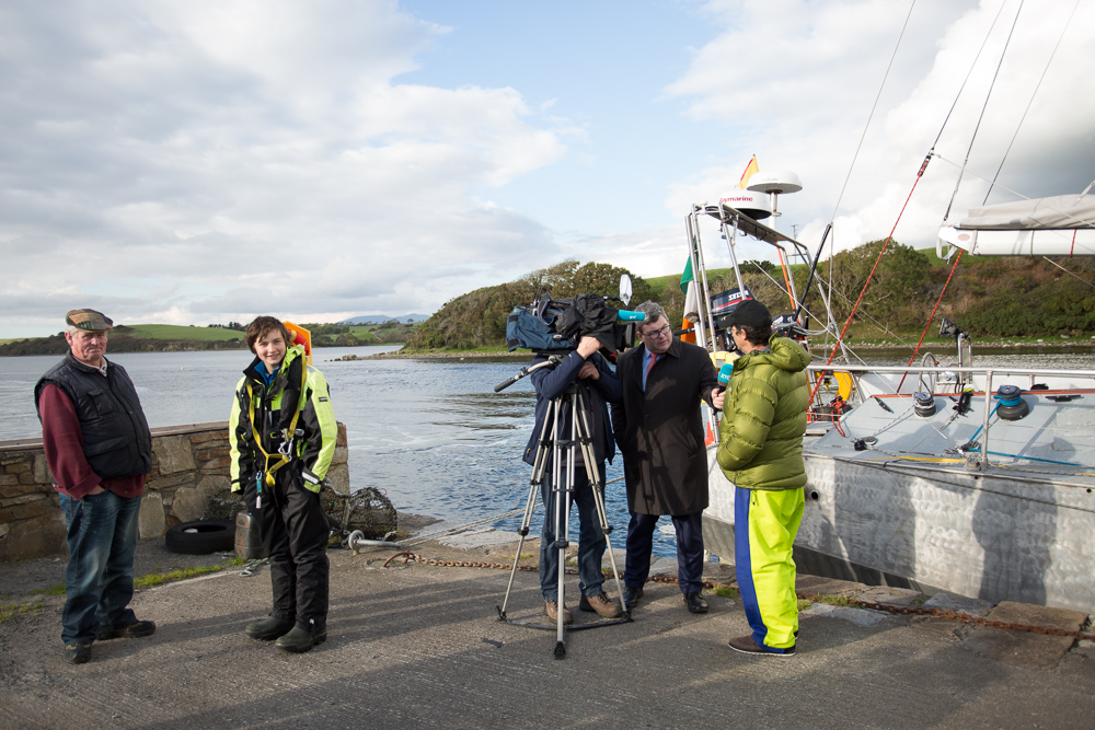
Yesterday we slipped Blacksod for Westport with Jarlath on board. Bringing Northabout back to Westport, where Jarlath had built her in 2001, was a poignant moment.
RTE News and several journalists were on the quay to record the event which was subsequently aired on the national TV news last night.
The sun is shining brightly again today although a front is expected tonight bringing heavy rain – but more importantly a wind shift. We leave for Dingle this afternoon after a most remarkable 36 hours during which we were treated to terrific hospitality. Many thanks to the hosting party who incidentally sailed Northabout through the NE and NW Passages over two seasons some years ago. So they fully recognise what this expedition had achieved.
[Edit – October 15th]
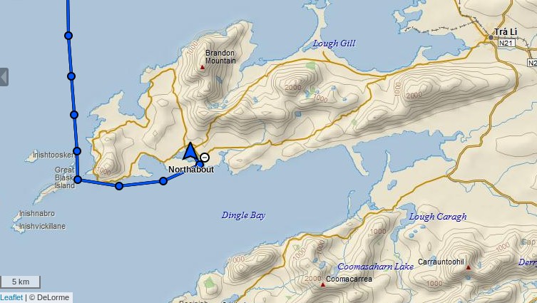
Having departed from Westport on yesterday evening’s high tide Northabout has now arrived in Dingle:
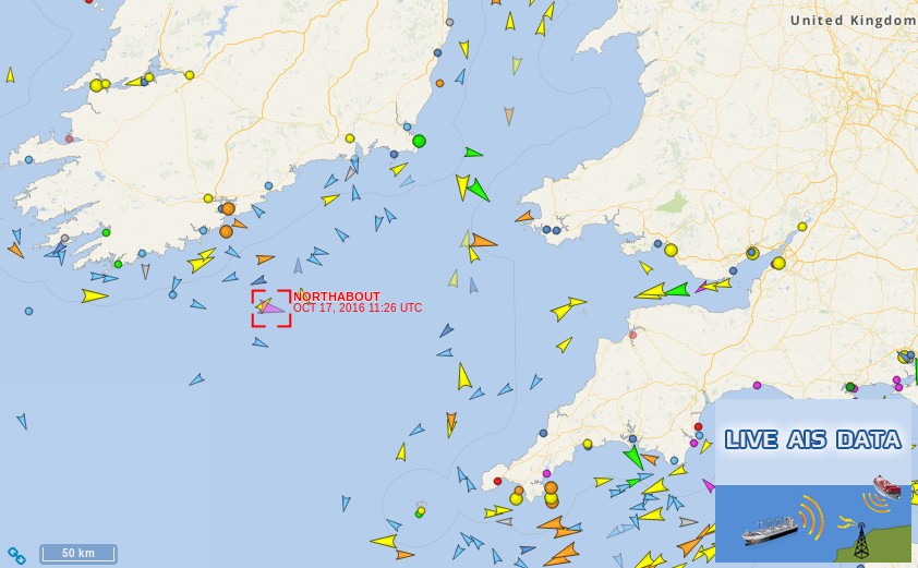
Beautiful morning, sun shining, a decent breeze from behind, and rolling down the Atlantic swells under full foresail at a steady 6kts, with bursts to 9kts if the waves pick us up. We are now well into the Celtic Sea, past Cork in the north, and enjoying the run home. We saw a dolphin last night, and four this morning so far.
Skipper Mike is keeping us on our toes, with no relaxing – constant AIS watch, and looking out for boats without AIS on radar.
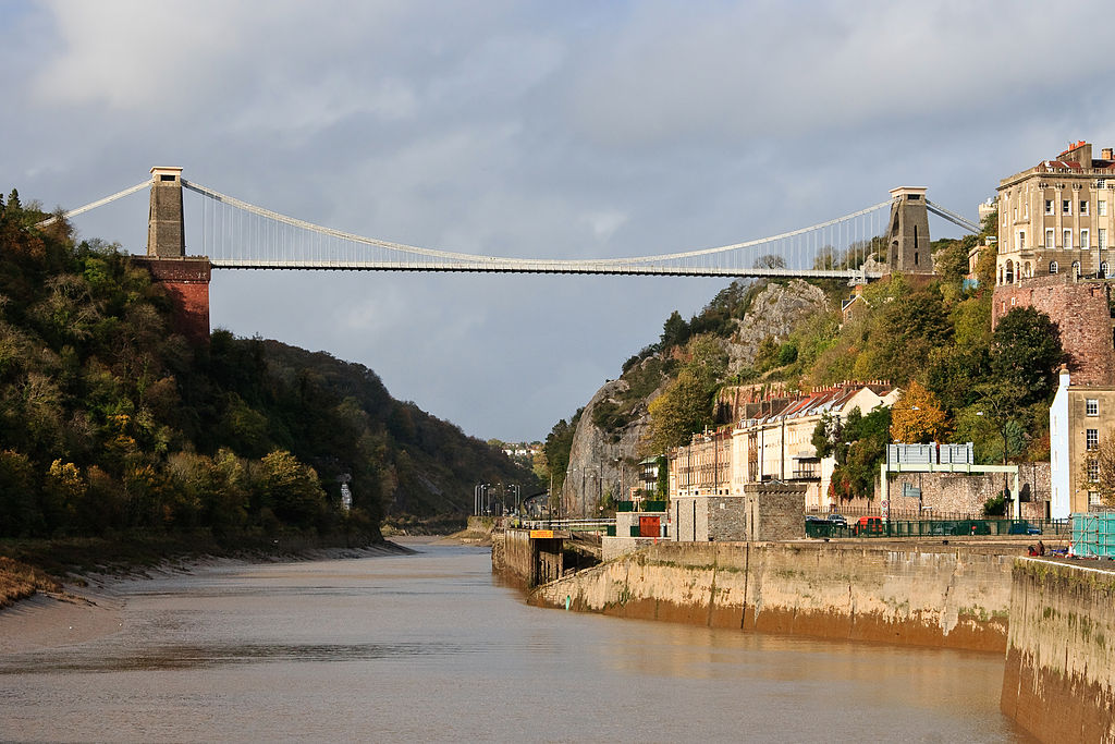
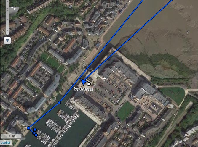
Assuming Northabout manages to safely avoid all the shipping in the Bristol Channel, on Thursday morning she is due to sail along the River Avon under Isambard Kingdom Brunel‘s Clifton Suspension Bridge:
With the wind and swell behind us we were doing twelve knots at times with an average of about seven. Amazingly that continued and continues to continue as we continue to head east.
Perhaps slightly ahead of schedule, Northabout has now arrived in Portishead:
The other blue line in the picture was recorded way back in June!
A storm is brewing in the Arctic. A big one! The crew of the yacht Northabout are currently sailing along the western shore of the Laptev Sea and reported earlier today that:
The sea is calm. Tomorrow a gale 8. But this moment is perfect.
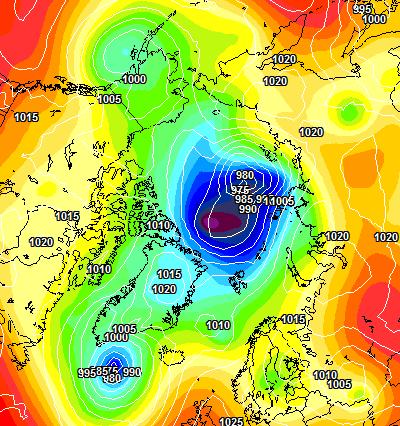
That perfect moment will not last long. Here is the current ECMWF forecast for midnight tomorrow:
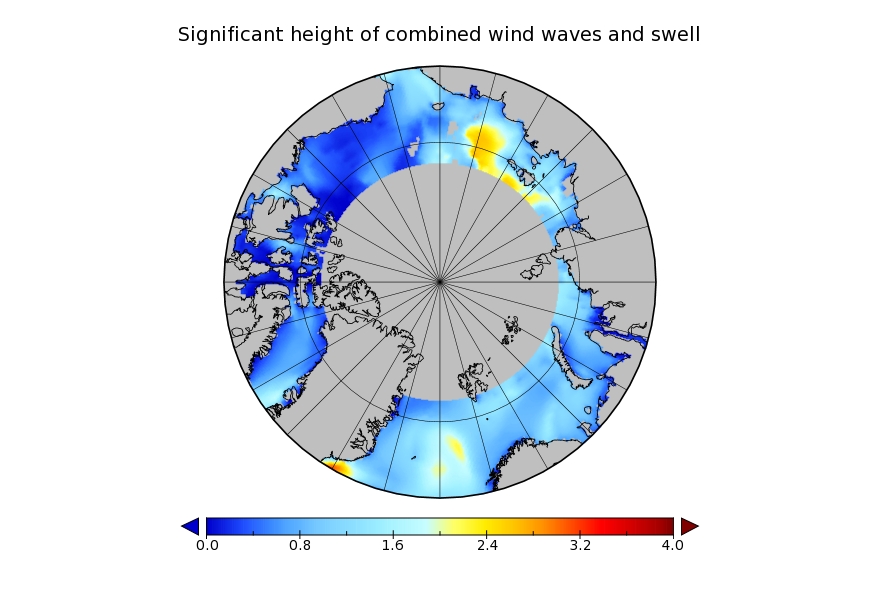
and here is the current Arctic surf forecast for 06:00 UTC on Monday:
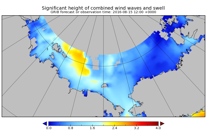
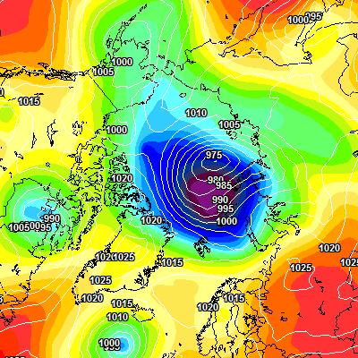
A 975 hPa low pressure system will be creating 3 meter waves with a period of around 8 seconds heading across the East Siberian Sea in the direction of the ice edge. By midnight on Monday the cyclone is forecast to have deepened to a central pressure below 970 hPa:
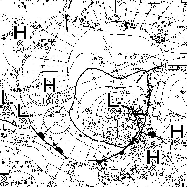
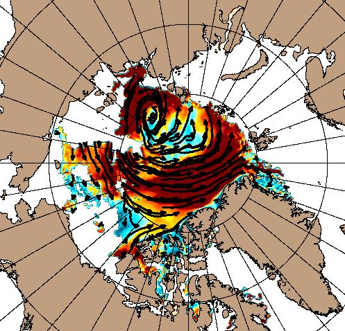
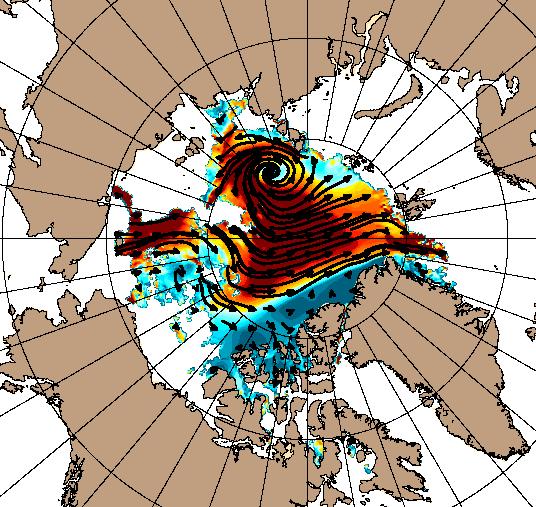
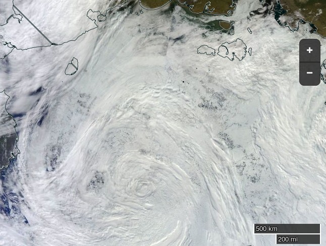
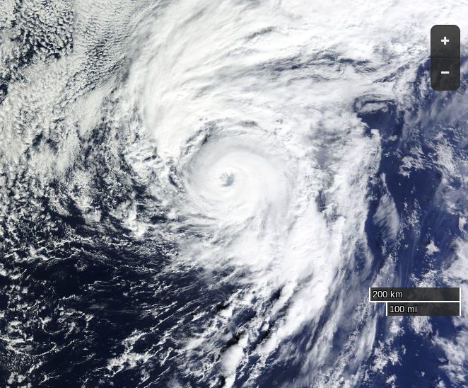
All of this is rather reminiscent of the “Great Arctic Cyclone” in the summer of 2012, which looked like this on August 7th:
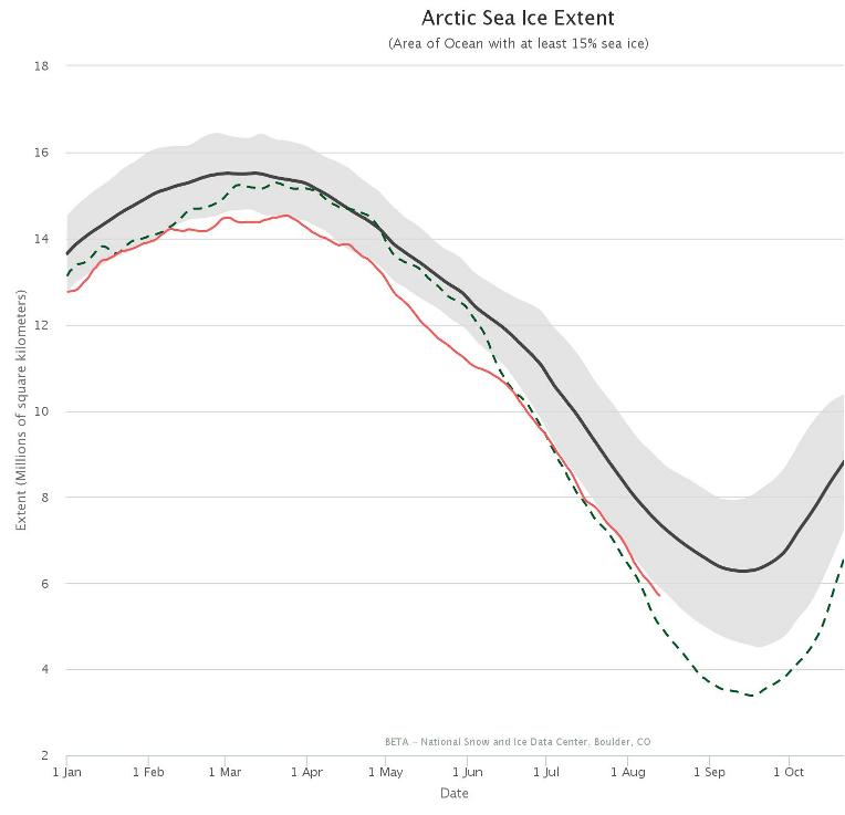
and which ultimately led to the lowest Arctic sea ice extent in the satellite record. Using the National Snow and Ice Data Center’s numbers that was 3.41 million square kilometers on September 16th 2012. Here’s the NSIDC’s current graph comparing 2012 with this year:
I wonder what the minimum for 2016 will be, and on what date?
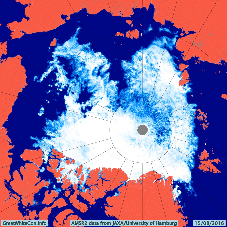
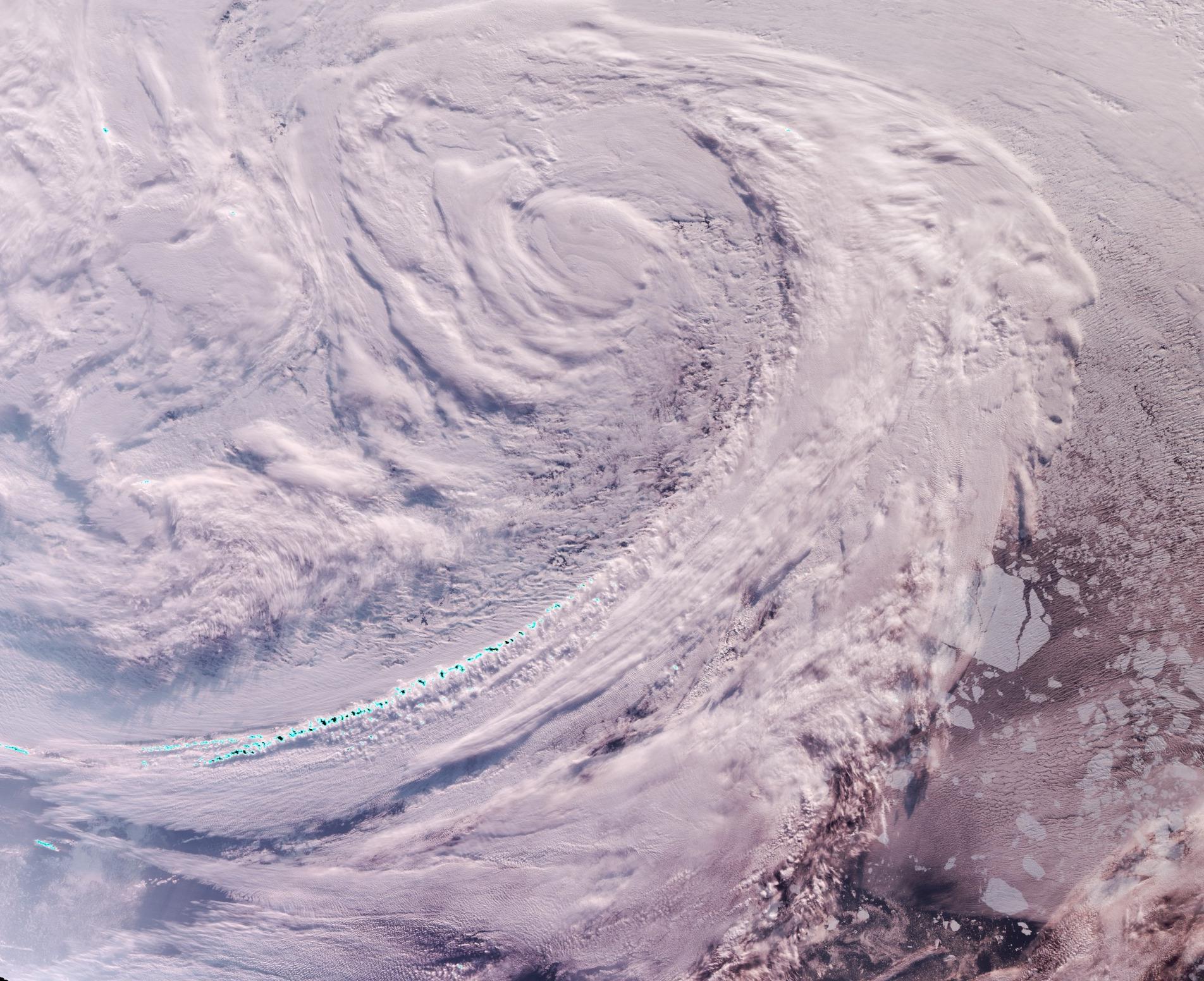
Here’s how the Great Arctic Cyclone of 2016 looks from on high this morning:
NASA Worldview “true-color” image of the ‘Great Arctic Cyclone’ on August 15th 2016, derived from the VIIRS sensor on the Suomi satellite
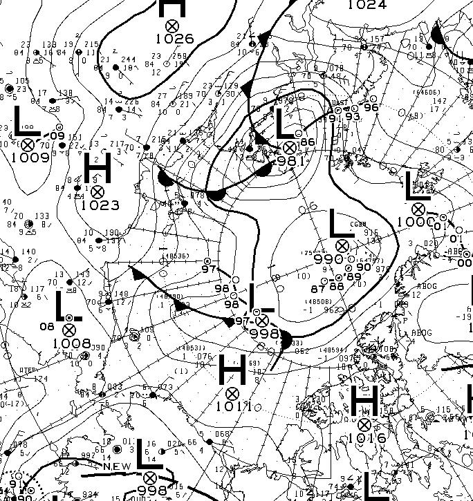
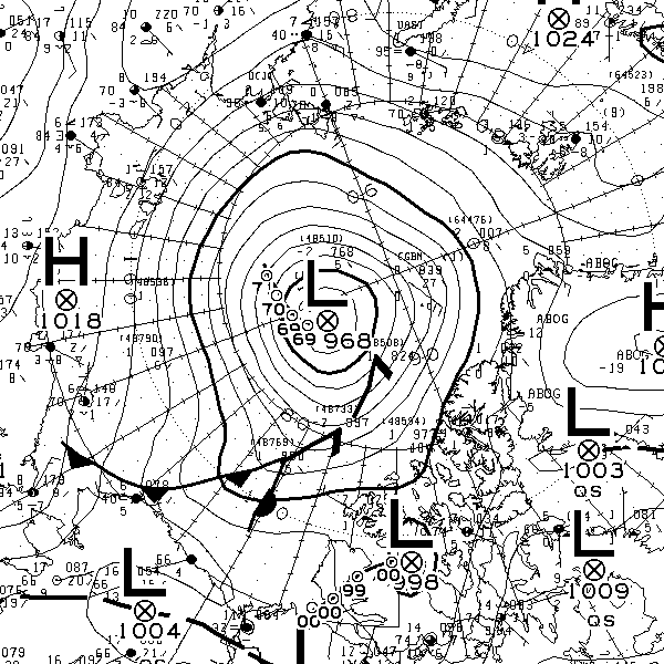
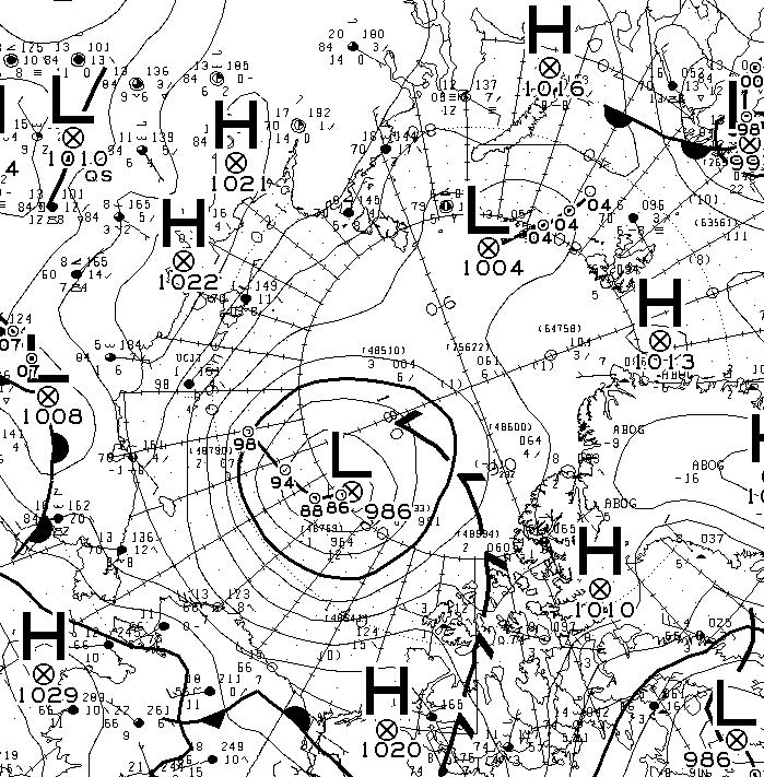
The latest synopsis from Environment Canada shows that the central pressure of the cyclone is now down to 974 hPa:
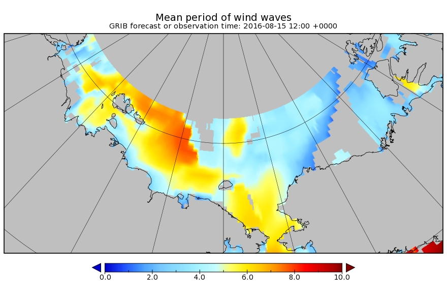
The WaveWatch III forecast for noon today UTC confirms the forecast of two days ago:
P.S. The Canadian 0600Z synopsis has the cyclone’s SLP down to 971 hPa:
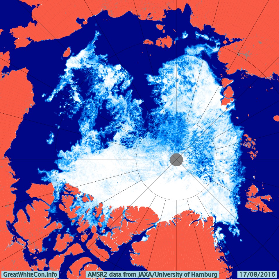
[Edit – August 16th]
This morning the cyclone’s SLP is down to 969 hPa:
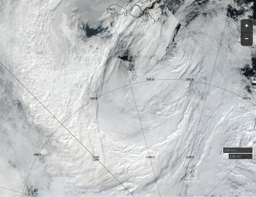
and the clouds over the Central Arctic are parting:
NASA Worldview “false-color” image of the Arctic Basin on August 16th 2016, derived from the MODIS sensor on the Terra satellite
Our favourite method of seeing through the clouds using the AMSR2 maps from the University of Hamburg doesn’t seem to working at the moment, so here’s one from the University of Bremen instead:
The cyclone central pressure is now up to 983 hPa, and some indications of the effect it has had on the sea ice in the Arctic are being revealed:
[Edit – August 19th]
According to Environment Canada the cyclone’s central pressure rose to 985 hPa earlier today:
However the 987 hPa low near the Canadian Arctic Archipelago is currently forecast to deepen below 980 hPa over the next 24 hours. Here’s the ECMWF forecast for first thing tomorrow morning:
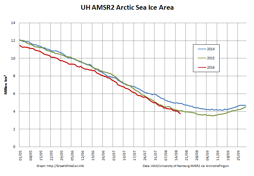
The high resolution AMSR2 Arctic sea ice area has reduced by another 133.5 thousand square kilometers since yesterday. A similar drop tomorrow will take us below the 2015 minimum.
[Edit – August 19th PM]
The MSLP of the rejuvenated cyclone had dropped to 976 hPa by 12:00 UTC today:
The ECMWF forecast for lunchtime tomorrow is for something similar:
[Edit – August 20th]
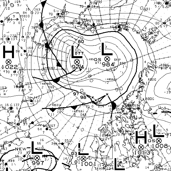
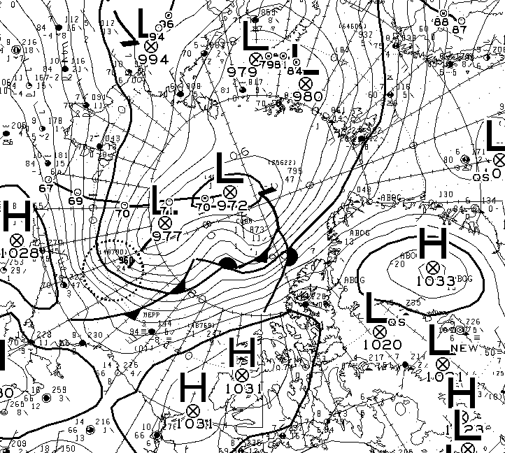
The current incarnation of the cyclone bottomed out at 971 hPa near the Canadian Arctic Archipelago:
The 72 hour forecast from ECMWF for the next phase of GAC 2016 is beginning to enter the realms of plausibility. Here’s what it reveals:
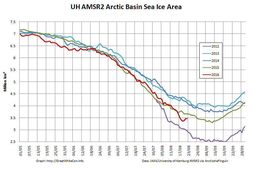
The University of Hamburg have been processing more AMSR2 data from 2012. You can argue until the cows come home about which is the best metric to peruse at this time of year, but try this one for size:
That’s the high resolution AMSR2 sea ice area for the Arctic Basin, comprising the CAB plus Beaufort, Chukchi, East Siberian and Laptev Seas.
[Edit – August 25th]
There’s a bit of a gap in the clouds over the Central Arctic today:
NASA Worldview “true-color” image of the Central Arctic Basin on August 25th 2016, derived from the MODIS sensor on the Terra satellite
This is merely the calm before the next storm. Here is the current ECMWF forecast for Saturday lunchtime (UTC):
Low pressure on the Siberian side of the Arctic and high pressure on the Canadian side producing an impressive dipole with lots of sea ice “drift” towards the Atlantic:
[Edit – August 27th]
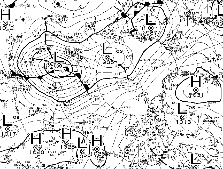
Saturday morning has arrived, and so has the predicted storm. As the centre of the cyclone crossed the coast of the East Siberian Sea its central pressure had fallen to 967 hPa, whilst the high pressure over Alaska had risen to 1028 hPa:
The effect of the earlier bursts of high wind is apparent in the high resolution AMSR2 sea ice area graph:
However they are not as apparent in the corresponding extent graph:
[Edit – August 28th]
As the centre of the cyclone heads for the North Pole the isobars are tightening across the last refuge of multi-year sea ice north of the Canadian Arctic Archipelago and Greenland:
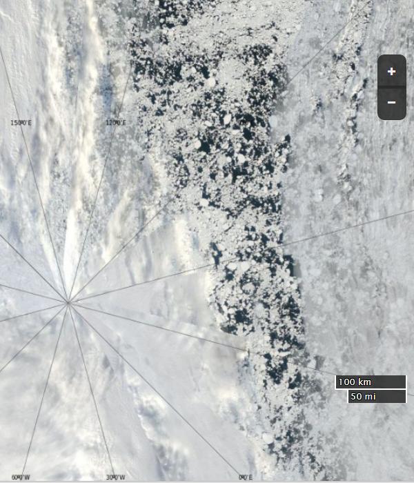
The area north of the East Siberian Sea that was predicted to bear the brunt of the wind and waves overnight is still covered in cloud. However the latest AMSR2 update from the University of Hamburg suggests that open water now stretches as far as 86 degrees north:
The skies over the northern Chukchi Sea have cleared to reveal this:
NASA Worldview “true-color” image of the northern Chukchi Sea on August 28th 2016, derived from the MODIS sensor on the Aqua satellite
[Edit – August 29th]
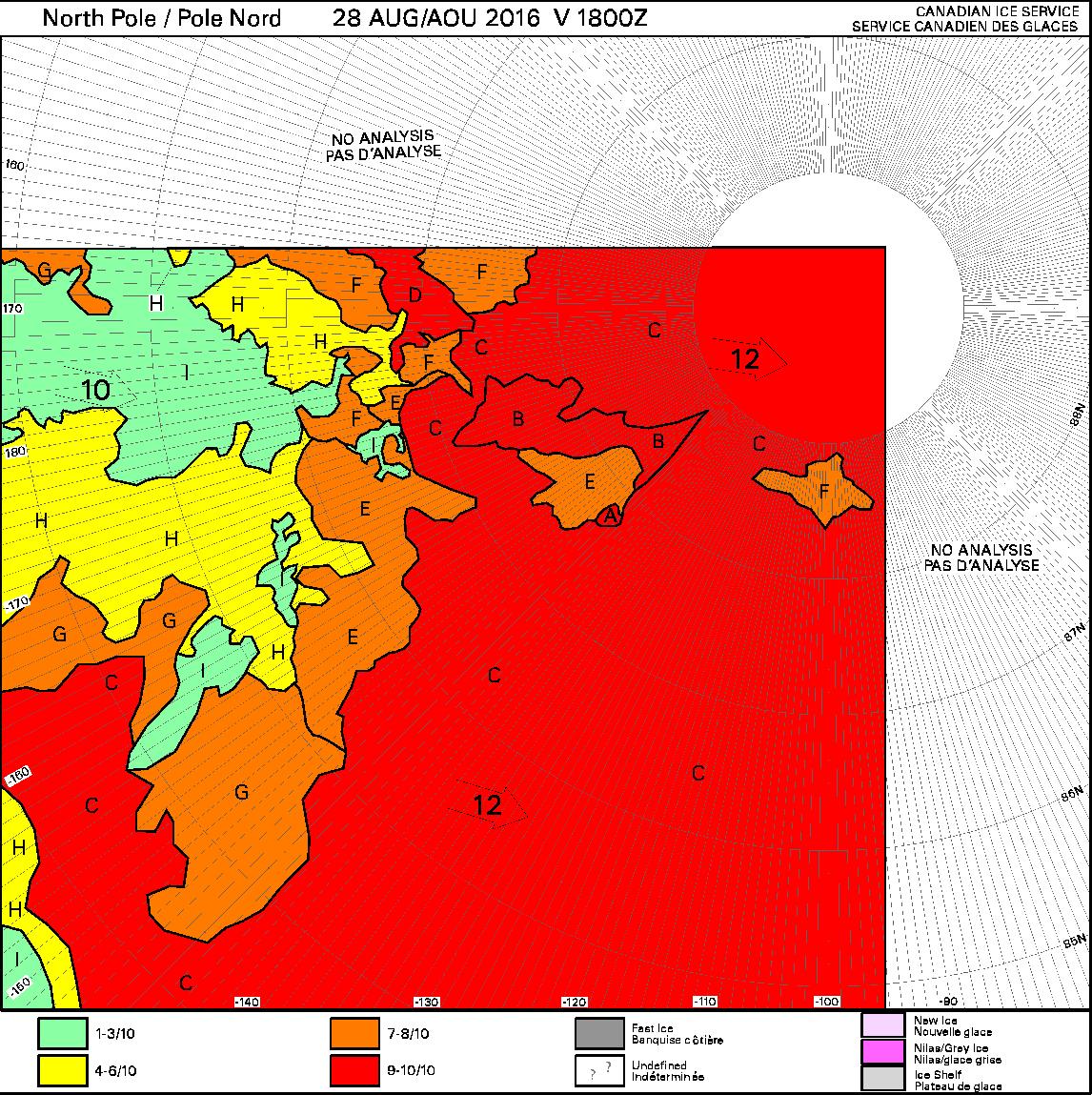
Some of the effects of the recent high winds can be judged by this Canadian Ice Service chart of ice concentration near the North Pole:
[Edit – September 1st]
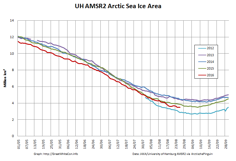
Arctic sea ice area continues to fall quickly for the time of year:
The recent dipole has finally caused some compaction of the scattered sea ice. Hence the high resolution AMSR2 extent is following suit and is now below last year’s minimum:
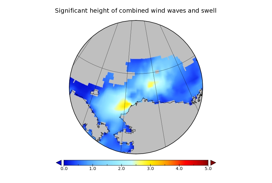
It looks like a storm is brewing in the Arctic. The long range weather forecasts for the Arctic have been remarkably unreliable recently, but this one is for a mere three days from now. WaveWatch III suggests there will be some significant waves in the Chukchi and Beaufort Seas this coming weekend, travelling in the direction of the ice edge:
WaveWatch III wave height forecast for July 17thWaveWatch III wave period forecast for July 17thWaveWatch III wind forecast for July 17th
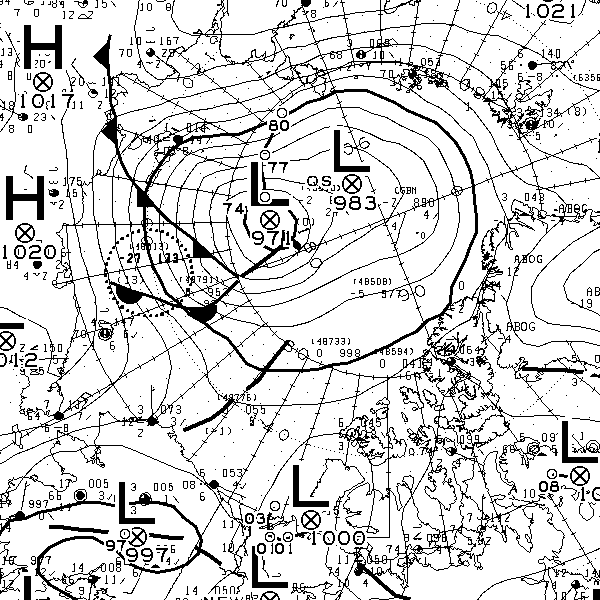
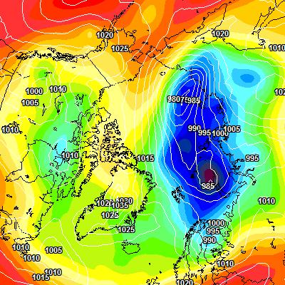
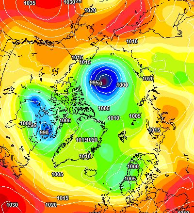
Another day has dawned, and the Environment Canada synoptic chart shows that the low pressure system currently over the Arctic has reached a central pressure of 990 hPa:
The latest ECMWF SLP forecast for tomorrow is firming up:
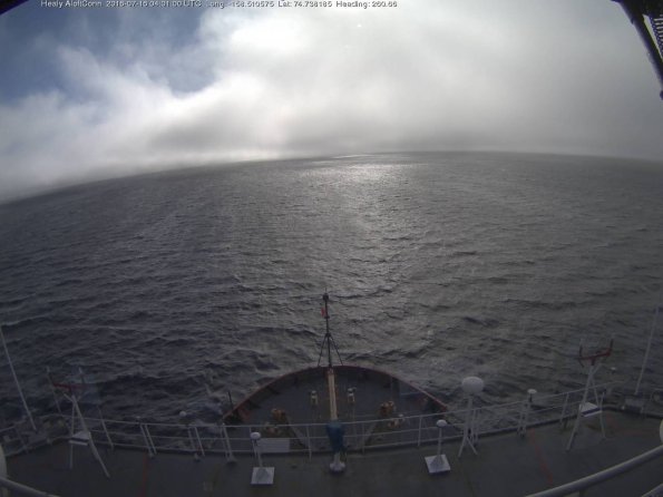
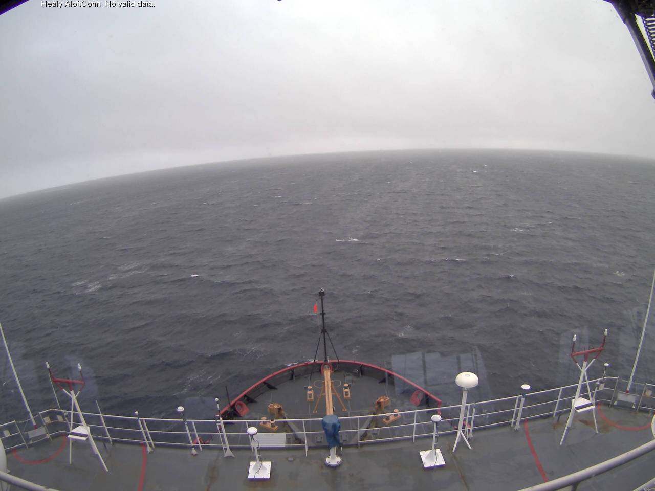
A modest swell is now visible from USCGC Healy’s “AloftCon” webcam:
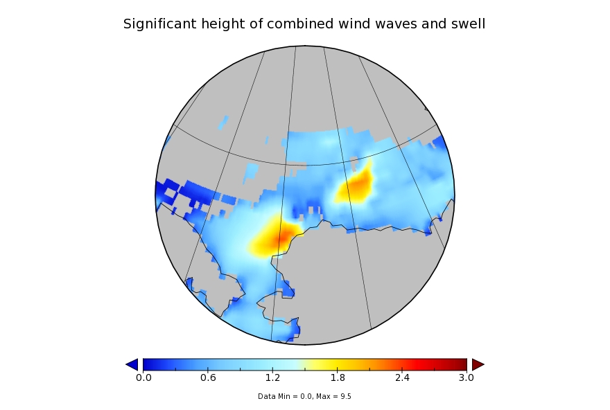
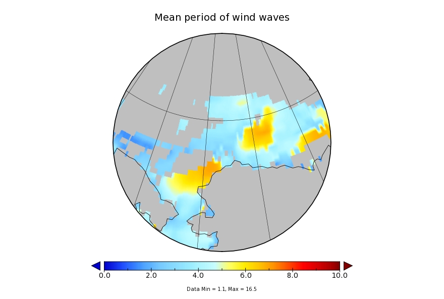
whilst the WaveWatch III forecast for tomorrow has dropped off to a significant wave height of around 2 metres with an average period of 7 seconds:
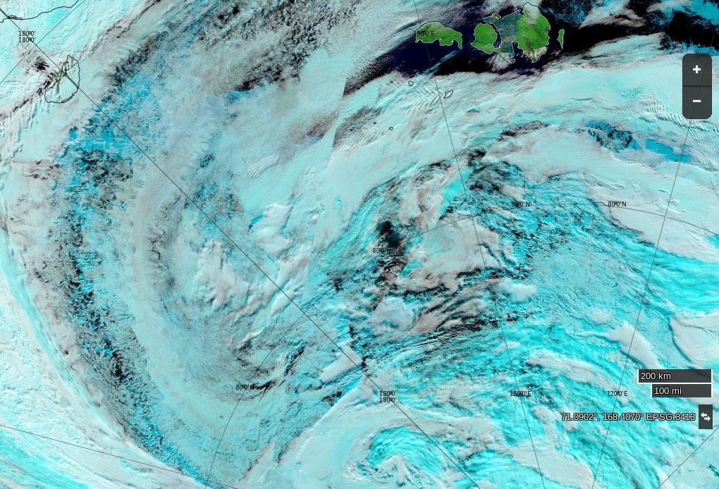
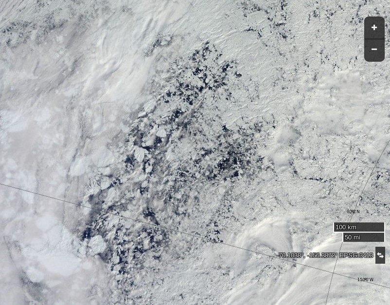
Meanwhile an image from the VIIRS instrument on the Suomi NPP satellite reveals the current storm in all its glory, together with confirmation that the “Big Block” multi-year ice floe north of Barrow has split asunder overnight:
[Edit July 17th 2016]
Sunday morning has now arrived. The storm in the Arctic looks to have bottomed out at 986 hPa central pressure. Here’s the Environment Canada synoptic chart for 00:00 this morning:
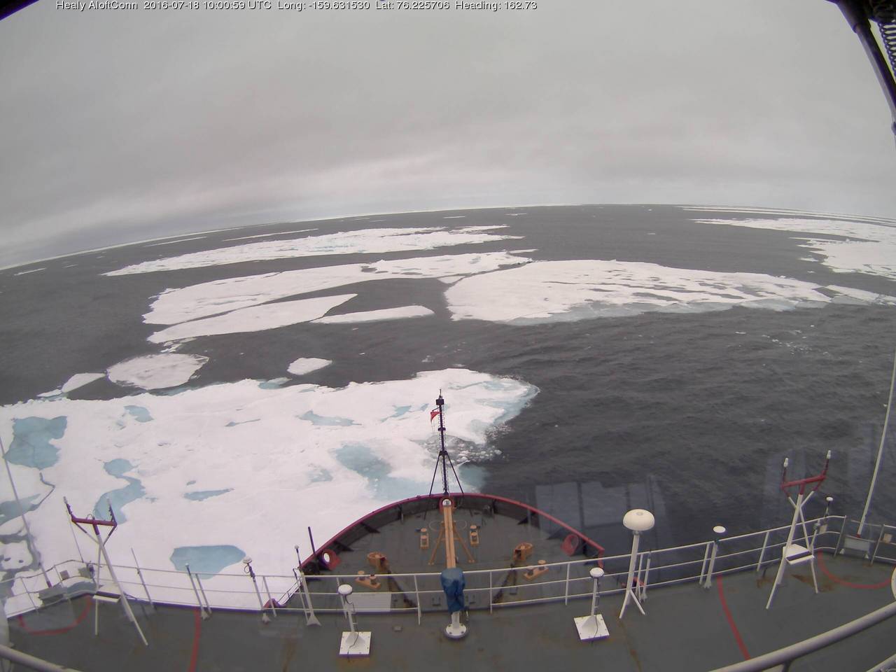
This is how the resultant swell looked from USCGC Healy at 06:00:
[Edit July 18th 2016]
Here’s what the Beaufort and Chukchi Sea north of Barrow look like this morning through the clouds:
NASA Worldview “true-color” image of the Beaufort Sea on July 18th 2016, derived from the MODIS sensor on the Terra satellite
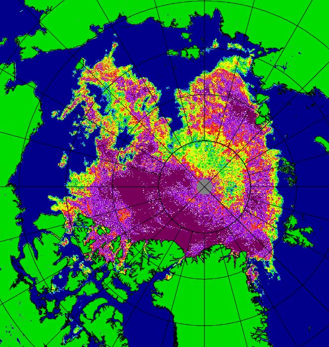
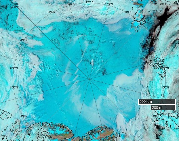
The remains of the now not so “Big Block” can just be made out in the bottom left. For a cloud free image here’s the latest AMSR2 passive microwave imagery of the area from the University of Hamburg:
The USCGC Healy and the remnants of the swell are in amongst the ice:
[Edit July 20th 2016]
As the remnants of the storm head off across the Canadian Arctic Archipelago here is what it has left in its wake in the Central Arctic Basin:
NASA Worldview “false-color” image of the Central Arctic Basin on July 19th 2016, derived from the MODIS sensor on the Aqua satelliteUniversity of Hamburg AMSR2 concentration visualisation of the Central Arctic on July 19th 2016
[Edit July 21st 2016]
The storm has dispersed the remaining ice in the Beaufort Sea over the last few days:
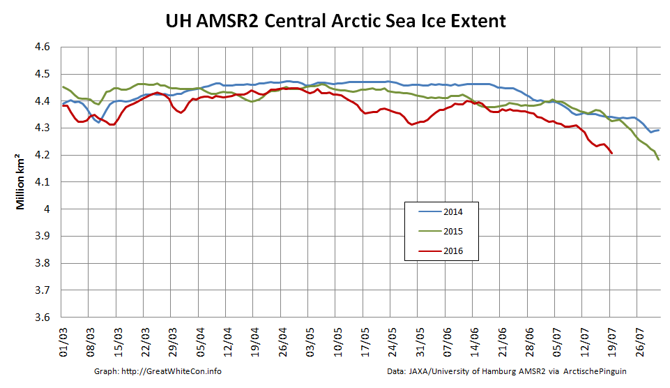
However across the Arctic as a whole sea ice area continues its downward trend:
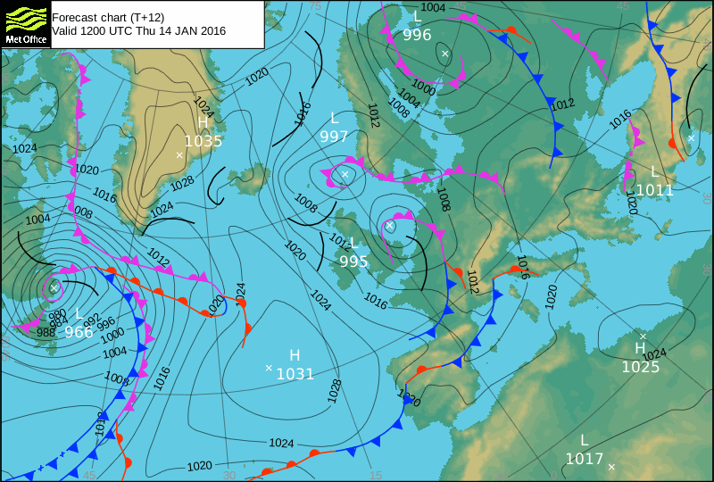
Strange things are happening in the North Atlantic at the moment. It’s the middle of January, and currently Hurricane Alex is heading straight for Greenland:
By the time he gets there Alex is due to meet another strong storm already spinning north of Newfoundland:
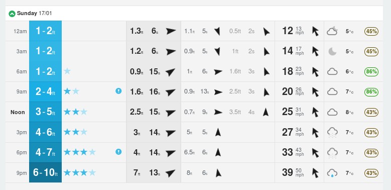
That combination is forecast by Magic Seaweed to bring some interesting surfing conditions to my local beach break here in Soggy South West England this coming weekend:
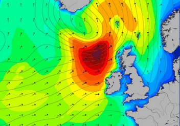
and here is their forecast for the Arctic Circle a day or so later:
A lot may change over the next week of course, but here’s ECMWF’s current prognosis for 192 hours from now, courtesy of MeteoCiel:
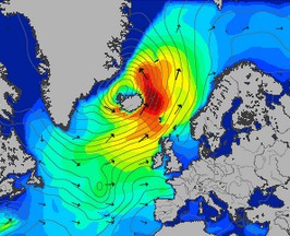
Finally, for the moment at least, here’s a reminder of what Storm Frank did to the sea ice in the Arctic at the very end of 2015:
This website uses cookies to improve your experience. We'll assume you're ok with this, but you can opt-out if you wish. Cookie settingsACCEPT
Privacy & Cookies Policy
Privacy Overview
This website uses cookies to improve your experience while you navigate through the website. Out of these, the cookies that are categorized as necessary are stored on your browser as they are essential for the working of basic functionalities of the website. We also use third-party cookies that help us analyze and understand how you use this website. These cookies will be stored in your browser only with your consent. You also have the option to opt-out of these cookies. But opting out of some of these cookies may affect your browsing experience.
Necessary cookies are absolutely essential for the website to function properly. This category only includes cookies that ensures basic functionalities and security features of the website. These cookies do not store any personal information.
Any cookies that may not be particularly necessary for the website to function and is used specifically to collect user personal data via analytics, ads, other embedded contents are termed as non-necessary cookies. It is mandatory to procure user consent prior to running these cookies on your website.