Regular readers will have realised by now that we’ve been pestering the Mail and The Telegraph with telephone calls and emails for weeks now. That’s because, as The Economist put it last weekend:
There are climate facts—and facts are stubborn things.
Both The Mail and The Telegraph have now corrected a couple of the gross inaccuracies they printed (virtually and/or physically) on September 8th, but many more remain. One of those is the identical phrase in both articles saying:
An unbroken ice sheet more than half the size of Europe already stretches from the Canadian islands to Russia’s northern shores.
The fact of the matter is that this statement is untrue. I’ve recently received a couple of letters about this from “The Daily Telegraph” signed by “Robert Winnett, Head of News”. Here’s an extract from the first one:
Them:
Reputable evidence exists to show an unbroken ice sheet more than half the size of Europe already stretches from the Canadian islands to Russia’s northern shore. This can be seen on the National Snow and Ice Data Center’s website [in the article] “A Real Hole Near the North Pole“. The site states that the average ice extent for August 2013 was 6.09 million square kilometres, which is more than half the size of Europe.
Us:
Have I got news for you Robert! If you’d read any of the articles on here, or watched any of the videos I linked to in my emails, that wasn’t the “fact” I was quibbling about. The fact is that the Arctic “ice sheet” was not “unbroken” and did not “stretch… to Russia’s northern shore” on September 8th 2013 and for considerable periods of time both before and after that date. Here’s an extract from The Telegraph’s second letter:
Them:
In reply to your enquiry, the Telegraph’s policy is to correct clear inaccuracies once we are alerted to them – and in appropriate cases update articles on our website.
Us:
I thought I’d already made this perfectly plain, but evidently not, so here’s yet another alert about clear inaccuracies in the “reporting” of climate science in The Telegraph:
I just received an emailed letter from the Telegraph’s Head of News, part of which reads as follows:
The Telegraph has looked into the matters you raise. As far as the points concerning ice extent are concerned, the incorrect information was derived from data published by the National Snow and Ice Data Center (NSIDC). The mistaken information was due to a typographical error, which the NSIDC only corrected after the article that incorporated it was published. We have since updated the online versions of the article and explained why this was necessary.
There is no mention in the letter of any “updates” or “corrections” being put into print. The Telegraph are thus telling much the same story as the Mail, which is of course wholly unsatisfactory when it comes to correcting the long list of “inaccuracies and misrepresentations” they have recently published regarding the sorry state of sea ice in the Arctic. This is how they’ve done it:
There has been a 29 per cent increase in the amount of ocean covered with ice compared to this time last year, the equivalent of 533,000 square miles.
In a rebound from 2012’s record low, an unbroken ice sheet more than half the size of Europe already stretches from the Canadian islands to Russia’s northern shores, days before the annual re-freeze is even set to begin.
The Northwest Passage from the Atlantic to the Pacific had remained blocked by pack-ice all year, forcing some ships to change their routes.
One ship has now managed to pass through, completing its journey on September 27.
with the following additional “explanation” at the end:
Update: As at the date the article was first posted it relied on information about ice extent from the Nasa-funded National Snow and Ice Data Centre (NSIDC). This information contained a typographical error which the NSIDC subsequently corrected. The article has been amended in line with the correct information.
In addition, we have amended our reference to the Northwest Passage following the successful traverse, completed on September 27 after our article was published, of the Danish bulk carrier Nordic Orion.
Us:
Should The Telegraph’s Head of News be interested in some slightly stale Northwest Passage news, here’s a picture published on econnexus.org on September 4th in an article linked to below, which takes a close look at the “pack ice” supposedly “blocking the North West Passage” on that date:
Sea ice concentration in the Northwest Passage on September 4th 2013, according to AMSR2
Update: After this article was published, a bulk carrier – the MV Nordic Orion – was able to pass through the Northwest Passage on its way from Vancouver to Finland.
c) “That has been enough to make a mockery of a much-publicised prediction, six years ago, by Prof Wieslaw Maslowski, of the Naval Postgraduate School in Monterey, California, that the Arctic would be entirely ice-free by 2013”
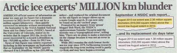
This weekend the Mail on Sunday admitted that the headline numbers in David Rose’s “And now it’s global COOLING!” article published on September 8th were inflated by a factor of approximately two. This is how they explained that discrepancy to their faithful readers:
The bottom of page 31 in the September 29th 2013 edition of the Mail on Sunday
Can you spot the MILLION square km blunder by the Mail on Sunday? For the benefit of the scientifically illiterate amongst you I’ll explain, as I did yesterday in an email to the Mail on Sunday’s Managing Editor:
It appears that whoever writes your headlines is unaware of the difference between “A MILLION km” and “a million square km”. The former is a distance, and hence has no area. The latter IS an area.
Them:
As you can clearly see, the Mail reported yesterday that:
On September 4, NSIDC, based at the University of Colorado, stated on its website that in August 2013 the Arctic ice cover recovered by a record 2.38 million sq km – 919,000 sq miles – from its 2012 low.
News of this figure was widely reported – including by MailOnline – on September 8.
A large hole (roughly 150 square kilometers or 58 square miles) of near-zero ice concentration appears to have opened up at about 87 degrees North latitude. Small areas of open water are common within the ice pack, even at the North Pole, as the ice pack shifts in response to winds and currents, resulting in cracks (called leads) in the ice. The current opening seen in our satellite imagery is much larger.
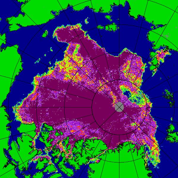
and the relevant area of the accompanying satellite imagery looks like this:
University of Bremen AMSR2 colour visualisation of Arctic sea ice concentration for September 2nd 2013
Them:
Since the Mail’s intrepid reporter evidently read those words and looked at that picture, why on Earth do you suppose that the Mail on Sunday printed these words four days later?
Days before the annual autumn re-freeze is due to begin, an unbroken ice sheet more than half the size of Europe already stretches from the Canadian islands to Russia’s northern shores.
Even more to the point, why on Earth do you suppose that the Mail on Sunday left those words unaltered following their September 28th edit of the online version of that article?
Us:
Here’s our latest video update on the 2013 Arctic sea ice refreeze. The “Polar Polynya” is prominent by its presence, as is the broad band of open water between the “broken ice sheet” and “Russia’s northern shores”:
Whatever David Rose may say in the Mail on Sunday, satellite images from high above the Arctic make it abundantly clear that there is in fact no “unbroken ice sheet [that] already stretches from the Canadian islands to Russia’s northern shores.”
Should further confirmation of that fact be needed, here’s our latest video analysis of the Arctic “refreeze” thus far:
As our video update points out, if you look carefully at the Arctic sea ice concentration maps derived from AMSR2 data, the large “Polar Polynya” visible is the region of the North Pole earlier this month seemed to be shrinking to nothing following the (provisional) NSIDC 2013 extent minimum on September 13th. However it now seems to have been given a new lease of life, as has the nearby “Barents Bite” of open water north of 85 degrees latitude.
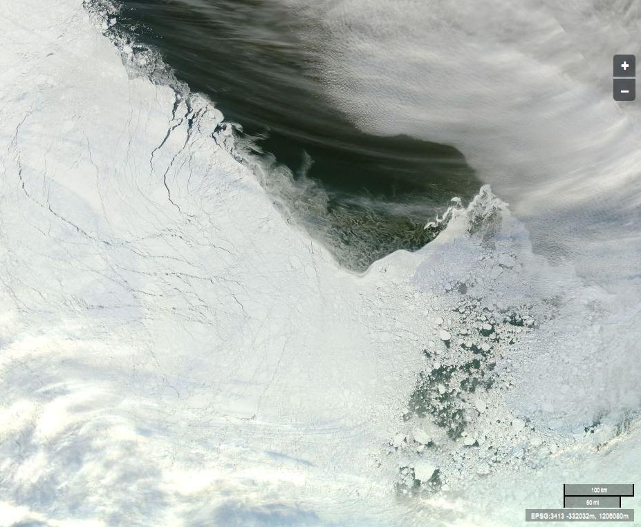
That area of the Arctic is currently obscured by cloud, but here’s an image captured by the Aqua satellite earlier today of the “broken ice sheet” off “Russia’s northern shores”:
The Arctic sea ice edge off “Russia’s northern shores” (Click for larger version)
Image courtesy of NASA Worldview from from the Aqua satellite.
Can you by any chance spot any cracks and/or holes in the supposedly “unbroken ice sheet”? Can you spot “Russia’s northern shores” for that matter?
In conclusion, for the moment at least, please note that we are now collecting all these periodical updates together in one handy location.
David Rose has now had another article published in the Mail on Sunday. The new one refers back to his previous words of wisdom about the Arctic, imparting this piece of information:
The Mail on Sunday’s report last week that Arctic ice has had a massive rebound this year from its 2012 record low was followed up around the world – and recorded 174,200 Facebook ‘shares’, by some distance a record for an article on the MailOnline website.
That’s a lot of people repeating a load of old nonsense! Here at GreatWhiteCon.info we also have a Facebook presence, so if you would like to share our alternative interpretation of what’s really going on in the Arctic please take a good look at:
and share that information with your friends, as long as it makes more sense to you than David Rose’s record breaking article. Meanwhile here in at Great Ivory Towers we’ve still only progressed as far as the third sentence in David’s article the weekend before last, which reads as follows:
Them:
Days before the annual autumn re-freeze is due to begin, an unbroken ice sheet more than half the size of Europe already stretches from the Canadian islands to Russia’s northern shores.
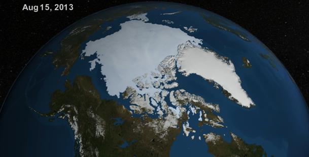
As you’ll discover below we’ve been experimenting with YouTube recently, where we stumbled upon a NASA video which led us to a page on NASA’s Goddard Space Flight Center web site where you can download a high resolution version of the same video. We did that, and then much like the Mail, we took a screenshot from the video to reveal an image remarkably like the one they published just over a week ago. Here it is:
NASA visualization of the Arctic on August 15th 2013
Us:
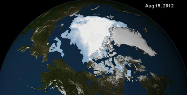
We also found that NASA’s Scientific Visualization Center had another similar video available for download, covering the period from August 1st to September 13th 2012. Here’s a screenshot we took from that video, for August 15th 2012:
NASA visualization of the Arctic on August 15th 2012
For some reason a similar image cannot however be found in David Rose’s Mail on Sunday article of September 8th 2013. Instead that contains an image labelled “August 27th 2012”. Whilst you ponder why the Mail was avoiding comparing like with like visually 9 days ago, here’s a little animation we’ve put together using alternative visualizations of Arctic sea ice, this time of ice concentration and generated by the University of Bremen. It shows how the sea ice cover has been changing from August 15th through to September 13th 2013, which may ultimately prove to be day of the minimum extent in 2013, using the NSIDC’s methodology at least. Note that it lingers for a while on August 27th, and we hope you like the sound track!
Verdict:
For reasons known only to themselves the Mail certainly weren’t comparing like with like visually on September 8th 2013. They evidently weren’t comparing like with like numerically either, since however hard we try comparing numbers from “the same time last year” we can’t come up with the Mail’s magic “60% increase”. Comparing NSIDC extent for August 15th 2013 with August 27th 2012 did however lead us to perform this bit of elementary arithmetic:
6.16 / 3.94 = 1.56 – A 56% increase.
However hard we try we still can’t get close to the Mail’s “nearly a million more square miles of ocean covered with ice than at the same time last year – an increase of 60 per cent”. We also challenge all and sundry to watch our video and then loudly proclaim, with a straight face, that “an unbroken ice sheet more than half the size of Europe already stretches from the Canadian islands to Russia’s northern shores”.
Our title today is an allusion to Bill Bruford’s “Five Percent For Nothing”, from the 1971 album “Fragile” by Yes. Here’s what the cover looks like:
Fragile cover art, by Roger Dean (image Wikipedia)
Them:
A chilly Arctic summer has left nearly a million more square miles of ocean covered with ice than at the same time last year – an increase of 60 per cent.
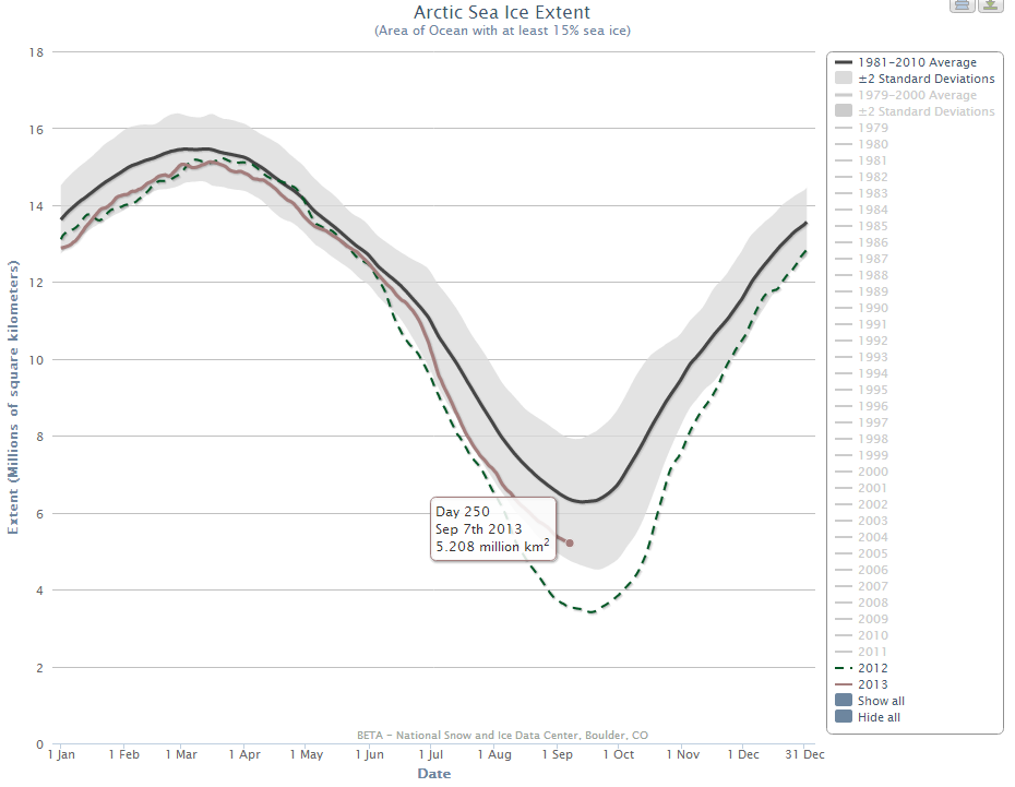
The sums are obviously rather tricky, so we’ve enlisted the aid of a spreadsheet. Here’s what it reveals to us:
Metric
Date
2012
2013
Increase
NSIDC Daily Extent (million km²)
Day 249
3.558
5.236
47.2%
NSIDC Daily Extent (million km²)
Sep 8th
3.523
5.179
47.0%
NSIDC Daily Extent (million km²)
Aug 27th
3.94
5.632
42.9%
NSIDC Daily Extent (million km²)
Aug 15th
4.845
6.159
27.1%
NSIDC Monthly Extent (million km²)
August
4.71
6.09
29.3%
Verdict:
Whichever way you look at things, on a “same time last year” basis at least, the magic number of 60% seems to be out of reach. Whatever the arithmetic David Rose actually performed, whether mentally or on his pocket calculator, it would appear not to involve comparing like with like. We have asked David and the Mail on a number of occasions what numbers he started from and what calculations he performed. We have received no answers as yet.
Getting back to our title, when you start to look at Arctic sea ice volume instead of extent, 160% of almost nothing is still almost nothing:
Let’s start at the very beginning. A very good place to start!
Them:
A chilly Arctic summer has left nearly a million more square miles of ocean covered with ice than at the same time last year – an increase of 60 per cent.
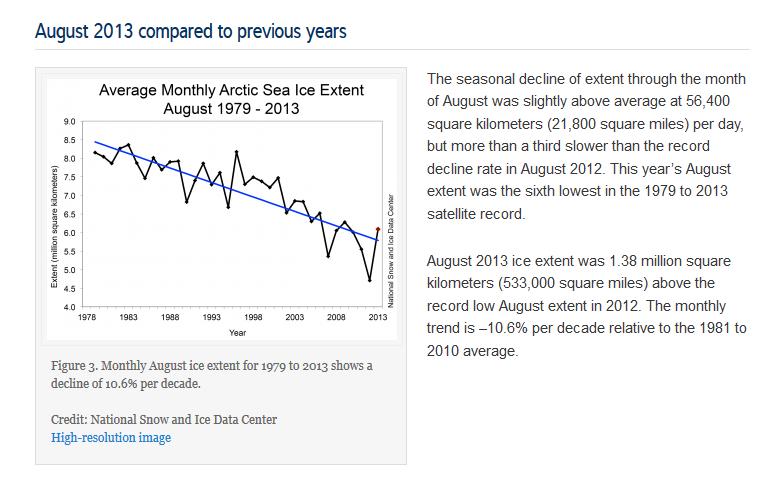
The Mailet. al. say “Nearly a million square miles”. When the floods in Boulder have receded the NSIDC will once again say “Just over half a million square miles”. Is that discrepancy sufficient to satisfy the Press Complaints Commission’s definition of “inaccurate, misleading or distorted information”?
This website uses cookies to improve your experience. We'll assume you're ok with this, but you can opt-out if you wish. Cookie settingsACCEPT
Privacy & Cookies Policy
Privacy Overview
This website uses cookies to improve your experience while you navigate through the website. Out of these, the cookies that are categorized as necessary are stored on your browser as they are essential for the working of basic functionalities of the website. We also use third-party cookies that help us analyze and understand how you use this website. These cookies will be stored in your browser only with your consent. You also have the option to opt-out of these cookies. But opting out of some of these cookies may affect your browsing experience.
Necessary cookies are absolutely essential for the website to function properly. This category only includes cookies that ensures basic functionalities and security features of the website. These cookies do not store any personal information.
Any cookies that may not be particularly necessary for the website to function and is used specifically to collect user personal data via analytics, ads, other embedded contents are termed as non-necessary cookies. It is mandatory to procure user consent prior to running these cookies on your website.