Tag Archives: Linette Boisvert

The 2021 Arctic Sea Ice Minimum Extent

The results of the ARCUS Sea Ice Prediction Network August call have been released, and here is the outlook for the 2021 minimum September mean Arctic sea ice extent:
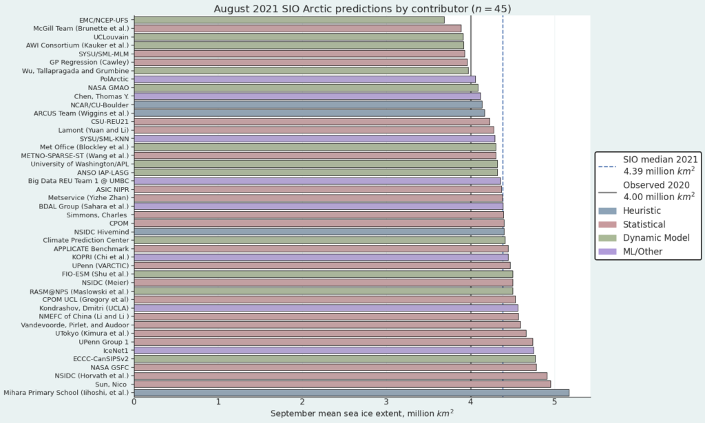
The median prediction for the mean sea ice extent during the month of September 2021 is 4.39 million km2. According to ARCUS:

As of 22 August 2021, the Arctic sea-ice extent was 5.58 (compared with 25 August 2020 value of 4.43) million square kilometers. Arctic sea-ice extent in 2021 remains well below the climatological median and has closely followed the 2012 values for much of the summer but has diverged to higher sea-ice extent starting in early August. The forecasts continue to support September 2021 mean sea-ice extent being well above the September 2020 value. July sea-ice retreat has been greatest in the Eurasian seas, particularly in the East Siberian Sea, making the 2021 ice edge well north of the long-term median edge in Eurasia. Sea ice retreated since the end of July along the northern coast of Alaska, although the ice edge is near its climatological position, which makes the Beaufort and Chukchi sea ice extent the largest at this time of year since 2006. A tongue of sea ice that has been present all summer continues to extend close to land in the Kara Sea, making the northeast passage likely to remain blocked for the first time in several years. Half the models which provide spatial data to the SIO predict that the tongue is likely to survive.

Now let’s take a look at a range of assorted extent measurements. Here’s the NSIDC’s 5 day average extent:

Continue reading The 2021 Arctic Sea Ice Minimum Extent
NASA Researches Storm Frank in the Arctic

Regular readers may recall that as 2016 began we pondered how “Storm Frank” might have affected the Arctic. Now NASA have published some research into that very topic, entitled ” The Impact of the Extreme Winter 2015/16 Arctic Cyclone on the Barents–Kara Seas”. The paper itself is paywalled, but according to an associated article on the NASA web site:

A large cyclone that crossed the Arctic in December 2015 brought so much heat and humidity to this otherwise frigid and dry environment that it thinned and shrunk the sea ice cover during a time of the year when the ice should have been growing thicker and stronger.

The cyclone formed on Dec. 28, 2015, in the middle of the North Atlantic, and traveled to the United Kingdom and Iceland before entering the Arctic on Dec. 30, lingering in the area for several days. During the height of the storm, the mean air temperatures in the Kara and Barents seas region, north of Russia and Norway, were 18 degrees Fahrenheit (10 degrees Celsius) warmer than what the average had been for this time of the year since 2003.

The extremely warm and humid air mass associated with the cyclone caused an amount of energy equivalent to the power used in one year by half a million American homes to be transferred from the atmosphere to the surface of the sea ice in the Kara-Barents region. As a result, the area’s sea ice thinned by almost 4 inches (10 centimeters) on average.

At the same time, the storm winds pushed the edges of the sea ice north, compacting the ice pack.

Here’s a video with commentary by Linette Boisvert, lead author of the paper:

From the commentary:

As a result of this cyclone, the concentration of the sea ice in the Barents and Kara Seas decreased by ten percent, and the sea ice edge moved northward. The loss in sea ice area during this time was equivalent to the size of Florida. Sea ice extent stayed low throughout the month of January with large parts of the Barents and Kara Seas remaining unseasonably ice-free, which probably helped contribute to a record low Arctic sea ice maximum.

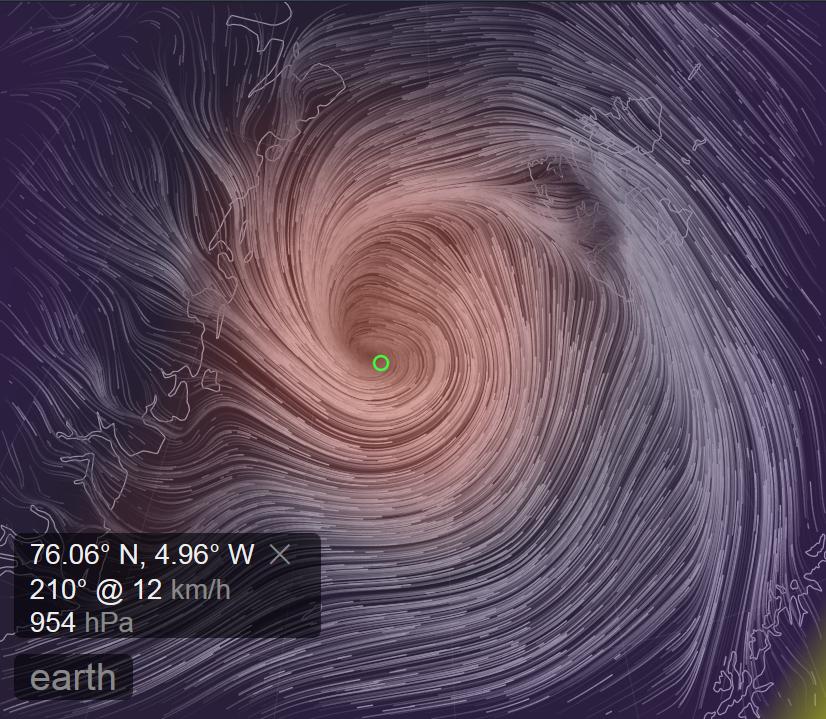
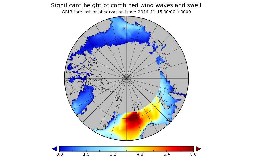
Somewhat earlier than last year another strong cyclone has been having a similar effect on the Arctic over the last week. A cyclone entered the Central Arctic via the Fram Strait, reaching a minimum central pressure of 954 hPa on November 14th:

fram-2016-11-14-1800

Here is the Wavewatch III wave height forecast for November 15th 2016:

significant_height_of_combined_w-in-multi_2-glo_30m-20161113_00049

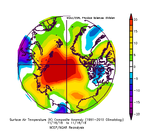
and here is NOAA’s temperature anomaly reanalysis for November 16th 2016:

noaatempanomaly-20161116

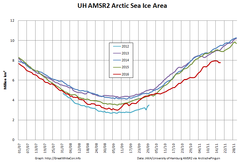
As a consequence of the strong winds, huge waves and 20 degrees Celsius temperature anomaly across much of the Arctic, sea ice area has been falling during a period when it is usually increasing rapidly:

uh-arctic-area-2016-11-19