Tag Archives: NASA

The United States’ National Aeronautics and Space Administration

Shock News! The Telegraph is Propagating Fake News About the Arctic!!

David Rose is mercifully quiet this weekend, but there’s no rest for the wicked! Christopher Booker in the Sunday Telegraph leads a bunch of the usual Alt-facts suspects in a barrage of fake news about our dearly beloved Arctic sea ice. According to Mr. Booker in the “Arctic Myths” section of his column today:

As the fake science of global warming continues to crumble, one scare story the zealots are determined to hold on to at all costs is their claim that ice in the Arctic is dangerously vanishing. Yet again lately we have been treated to a barrage of such headlines as “Hottest Arctic on record triggers massive ice melt”.

The nearest we got to such a headline here at the Great White Con was “Arctic Sea Ice News from AGU” in which article we showed images which said things like:

arctictemp_map_graph_2015-16_620

That’s because last year was the *hottest year on record in the Arctic! Undeterred by mere facts Mr. Booker continues:

Booker-NSIDC-20170226

But that ever-diligent blogger Paul Homewood has drawn on official sources such as the US National Snow and Ice Data Center to uncover what is actually happening. Under “Arctic Fake News”, on NotALotOfPeopleKnowThat, he posted a graph showing that last week the extent of sea ice was much the same as it has been at this date ever since 2001. Indeed, according to the Danish Meteorological Institute, there is even more of it today than in February 2006, and it is also significantly thicker. Back in 2008 much of the ice was only a metre thick. Today that has risen to two metres, and in some places four.

Mr. Booker appears to be more than somewhat confused, since this is what the DMI Arctic sea ice extent graph he links to reveals:

DMI_nh_iceextent_daily_5years_20170225

In addition the DMI thickness maps he refers to aren’t available at any of the places he mentions! Not a lot of people know that he was probably thinking of another recent article by Paul Homewood entitled “Arctic Ice Fake News“, which includes these two DMI thickness maps:

cice_combine_thick_sm_en_20080218

cice_combine_thick_sm_en_20170218

Even without considering other sources of Arctic thickness and/or volume data it is quite clear from the two volume graphs that according to the Danish Meteorological Institue Arctic sea ice volume is significantly lower this year than it was in 2008. If Arctic sea ice extent is greater this year and the volume is lower then the laws of physics (which not even the combined talents of Messrs Homewood and Booker can change) dictate that its average thickness must be LESS this year than in 2008!

Mr Booker blunders on:

The DMI data also show that the Greenland ice sheet, which we are told is melting at horrendous speed, is actually growing this year at a record rate, to a size way above its average for the past 26 years. And the most authoritative record of Northern Hemisphere snow cover shows this year’s ranking as one of the six highest since 1967.

He seems blissfully unaware that the “DMI data” to which he refers is the output of a DMI climate model that attempts to determine the “surface mass balance” of the Greenland ice sheet. He seems to think it’s a measurement of the mass of the Greenland ice sheet, which it isn’t. However this is, courtesy of NASA:

GreenlandGrace-20170213

In his bubble of astounding Arctic ignorance Mr. Booker continues:

The Deplorable Climate Science blog, run by US expert Tony Heller, gleefully reproduces a 2007 headline: “Scientists: ‘Arctic is screaming’, global warming may have passed tipping point”. As Heller comments: “The Arctic is indeed screaming at climate scientists – to shut up.”

Now as luck would have it I have been (vainly!) attempting to persuade Mr. Heller “to shut up” on the very article Mr. Booker references! Let’s take a quick look at a couple of highlights shall we?

February 22, 2017 at 12:01 am

At the risk of repeating myself, need I say more?

PIOMAS-Jan-19Years

It seems safe to assume that Mr. Booker wasn’t reading Mr Heller’s blog on or after February 22nd does it not? Otherwise he would surely have had second thoughts about writing such a ludicrous phrase as “there is even more of it today than in February 2006”?

Then of course there’s the burning question of the “Hottest Arctic on record”

February 22, 2017 at 5:59 pm

At the risk of (repeating myself)² AZ, here’s some “higher atmospheric air temperatures” for you:

DMI-FDD-20170218

If Mr. Booker had browsed Mr. Heller’s blog slightly more diligently he might even have seen this from the much maligned NOAA:

February 20, 2017 at 11:06 am

You seem to have forgotten about spring Gail? Here’s April:

NOAA-NH-Snow-April

Here’s the May graph from “the most authoritative record of Northern Hemisphere snow cover” for good measure:

Rutgers-NH-Snow-May

To summarise, Messrs Booker and Homewood could have confined their due diligence on their assorted Arctic articles to reading my comments on Mr. Heller’s blog. Having done so it would quickly have become apparent to them that every single point they made was in actual fact a “fake fact”.

The inevitable conclusion is that they have no interest whatsoever in establishing the actual facts about the Arctic. All they are interested in is propagating “fake news” about the Arctic as far and as wide as possible in pursuit of a common “agenda”. As is David Rose.

* Since satellite records began.

NASA Researches Storm Frank in the Arctic

Regular readers may recall that as 2016 began we pondered how “Storm Frank” might have affected the Arctic. Now NASA have published some research into that very topic, entitled ” The Impact of the Extreme Winter 2015/16 Arctic Cyclone on the Barents–Kara Seas”. The paper itself is paywalled, but according to an associated article on the NASA web site:

A large cyclone that crossed the Arctic in December 2015 brought so much heat and humidity to this otherwise frigid and dry environment that it thinned and shrunk the sea ice cover during a time of the year when the ice should have been growing thicker and stronger.

The cyclone formed on Dec. 28, 2015, in the middle of the North Atlantic, and traveled to the United Kingdom and Iceland before entering the Arctic on Dec. 30, lingering in the area for several days. During the height of the storm, the mean air temperatures in the Kara and Barents seas region, north of Russia and Norway, were 18 degrees Fahrenheit (10 degrees Celsius) warmer than what the average had been for this time of the year since 2003.

The extremely warm and humid air mass associated with the cyclone caused an amount of energy equivalent to the power used in one year by half a million American homes to be transferred from the atmosphere to the surface of the sea ice in the Kara-Barents region. As a result, the area’s sea ice thinned by almost 4 inches (10 centimeters) on average.

At the same time, the storm winds pushed the edges of the sea ice north, compacting the ice pack.

Here’s a video with commentary by Linette Boisvert, lead author of the paper:

From the commentary:

As a result of this cyclone, the concentration of the sea ice in the Barents and Kara Seas decreased by ten percent, and the sea ice edge moved northward. The loss in sea ice area during this time was equivalent to the size of Florida. Sea ice extent stayed low throughout the month of January with large parts of the Barents and Kara Seas remaining unseasonably ice-free, which probably helped contribute to a record low Arctic sea ice maximum.

Somewhat earlier than last year another strong cyclone has been having a similar effect on the Arctic over the last week. A cyclone entered the Central Arctic via the Fram Strait, reaching a minimum central pressure of 954 hPa on November 14th:

fram-2016-11-14-1800

Here is the Wavewatch III wave height forecast for November 15th 2016:

significant_height_of_combined_w-in-multi_2-glo_30m-20161113_00049

and here is NOAA’s temperature anomaly reanalysis for November 16th 2016:

noaatempanomaly-20161116

As a consequence of the strong winds, huge waves and 20 degrees Celsius temperature anomaly across much of the Arctic, sea ice area has been falling during a period when it is usually increasing rapidly:

uh-arctic-area-2016-11-19

NSIDC Announce The 2016 Arctic Sea Ice Maximum Extent

In the latest edition of their “Arctic Sea Ice News” the United States’ National Snow and Ice Data Center have announced that:

Arctic sea ice appears to have reached its annual maximum extent on March 24, and is now the lowest maximum in the satellite record, replacing last year’s record low. This year’s maximum extent occurred later than average. A late season surge in ice growth is still possible. NSIDC will post a detailed analysis of the 2015 to 2016 winter sea ice conditions in early April.

NSIDC-20160327

On March 24, 2016, Arctic sea ice likely reached its maximum extent for the year, at 14.52 million square kilometers (5.607 million square miles). This year’s maximum ice extent was the lowest in the satellite record, with below-average ice conditions everywhere except in the Labrador Sea, Baffin Bay, and Hudson Bay. The maximum extent is 1.12 million square kilometers (431,000 square miles) below the 1981 to 2010 average of 15.64 million square kilometers (6.04 million square miles) and 13,000 square kilometers (5,000 square miles) below the previous lowest maximum that occurred last year. This year’s maximum occurred twelve days later than the 1981 to 2010 average date of March 12. The date of the maximum has varied considerably over the years, occurring as early as February 24 in 1996 and as late as April 2 in 2010.

NASA’s Goddard Space Flight Center has also made a similar announcement, which includes this video:

The new record low follows record high temperatures in December, January and February around the globe and in the Arctic. The atmospheric warmth probably contributed to this lowest maximum extent, with air temperatures up to 10 degrees Fahrenheit above average at the edges of the ice pack where sea ice is thin, said Walt Meier, a sea ice scientist at NASA’s Goddard Space Flight Center in Greenbelt, Maryland.

The wind patterns in the Arctic during January and February were also unfavorable to ice growth because they brought warm air from the south and prevented expansion of the ice cover. But ultimately, what will likely play a bigger role in the future trend of Arctic maximum extents is warming ocean waters, Meier said.

“It is likely that we’re going to keep seeing smaller wintertime maximums in the future because in addition to a warmer atmosphere, the ocean has also warmed up. That warmer ocean will not let the ice edge expand as far south as it used to,” Meier said. “Although the maximum reach of the sea ice can vary a lot each year depending on winter weather conditions, we’re seeing a significant downward trend, and that’s ultimately related to the warming atmosphere and oceans.” Since 1979, that trend has led to a loss of 620,000 square miles of winter sea ice cover, an area more than twice the size of Texas.

This year’s record low sea ice maximum extent will not necessarily result in a subsequent record low summertime minimum extent, Meier said. Summer weather conditions have a larger impact than the extent of the winter maximum in the outcome of each year’s melt season; warm temperatures and summer storms make the ice melt fast, while if a summer is cool, the melt slows down.

Neither NASA or the NSIDC comment on one of the striking things about this winter’s NSIDC extent chart, which has effectively “plateaued” during March 2016 following an initial peak of 14.48 million square kilometers on March 2nd, which was only recently exceeded. This is also illustrated by the JAXA Arctic sea ice extent metric, for which the 2016 maximum was 13.96 million square kilometers on February 29th:

JAXA-20160328

Now that the start of 2016 Arctic sea ice melting season has been called, albeit slightly hesitantly, by the experts at the NSIDC let’s also take a look at Cryosphere Today Arctic sea ice area:

CT-20160327

The preliminary peak which we announced on March 16th has also recently been exceeded, but we now feel supremely confident in predicting that the 2016 CT area maximum will be less than 13 million square kilometers for the first time ever in the satellite record.

Thus begins what promises to be a very interesting 2016 Arctic sea ice melting season! As the NSIDC puts it:

There is little correlation between the maximum winter extent and the minimum summer extent—this low maximum does not ensure that this summer will see record low ice conditions. A key factor is the timing of widespread surface melting in the high Arctic. An earlier melt onset is important to the amount of energy absorbed by the ice cover during the summer. If surface melting starts earlier than average, the snow darkens and exposes the ice below earlier, which in turn increases the solar heat input, allowing more ice to melt. With the likelihood that much of the Arctic cover is somewhat thinner due to the warm winter, early surface melting would favor reduced summer ice cover.

How to Make a Complete RSS of Yourself (With Sausages)

In the wake of the recent announcement from NASA’s Goddard Institute for Space Studies that global surface temperatures in February 2016 were an extraordinary 1.35 °C above the 1951-1980 baseline we bring you the third in our series of occasional guest posts.

Today’s article is a pre-publication draft prepared by Bill the Frog, who has also authorised me to reveal to the world the sordid truth that he is in actual fact the spawn of a “consumated experiment” conducted between Kermit the Frog and Miss Piggy many moons ago. Please ensure that you have a Microsoft Excel compatible spreadsheet close at hand, and then read on below the fold.


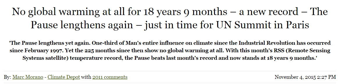
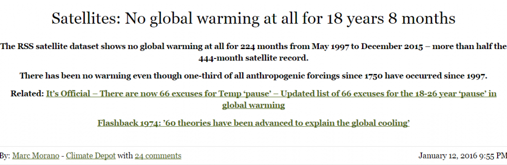
­­­­In a cleverly orchestrated move immaculately timed to coincide with the build up to the CoP21 talks in Paris, Christopher Monckton, the 3rd Viscount Monckton of Brenchley, announced the following startling news on the climate change denial site, Climate Depot

Morano1

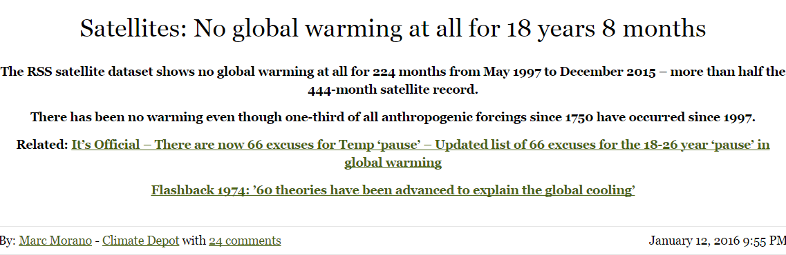
Upon viewing Mr Monckton’s article, any attentive reader could be forgiven for having an overwhelming feeling of déjà vu. The sensation would be entirely understandable, as this was merely the latest missive in a long-standing series of such “revelations”, stretching back to at least December 2013. In fact, there has even been a recent happy addition to the family, as we learned in January 2016 that …

Morano2

The primary eye-candy in Mr Monckton’s November article was undoubtedly the following diagram …

https://lh3.googleusercontent.com/-xAdiohdkcU4/VjpSKNYP9SI/AAAAAAACa8Q/639el4qIzpM/s720-Ic42/monckton1.png

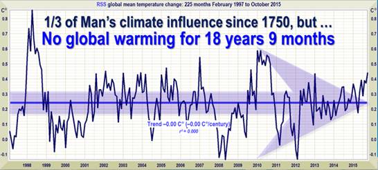
Fig 1: Copied from Nov 2015 article in Climate Depot

It is clear that Mr Monckton has the ability to keep churning out virtually identical articles, and this is a skill very reminiscent of the way a butcher can keep churning out virtually identical sausages. Whilst on the subject of sausages, the famous 19th Century Prussian statesman, Otto von Bismarck, once described legislative procedures in a memorably pithy fashion, namely that … “Laws are like sausages, it is better not to see them being made”.

One must suspect that those who are eager and willing to accept Mr Monckton’s arguments at face value are somehow suffused with a similar kind of “don’t need to know, don’t want to know” mentality. However, some of us are both able and willing to scratch a little way beneath the skin of the sausage. On examining one of Mr Monckton’s prize sausages, it takes all of about 2 seconds to work out what has been done, and about two minutes to reproduce it on a spreadsheet. That simple action is all that is needed to see how the appropriate start date for his “pause” automatically pops out of the data.

However, enough of the hors d’oeuvres, it’s time to see how those sausages get made. Let’s immediately get to the meat of the matter (pun intended) by demonstrating precisely how Mr Monckton arrives at his “no global warming since …” date. The technique is incredibly straightforward, and can be done by anyone with even rudimentary spreadsheet skills.

One basically uses the spreadsheet’s built-in features, such as the SLOPE function in Excel, to calculate the rate of change of monthly temperature over a selected time period. The appropriate command would initially be inserted on the same row as the first month of data, and it would set to range to the latest date available. This would be repeated (using a feature such as Auto Fill) on each subsequent row, down as far as the penultimate month. On each row, the start date therefore advances by one month, but the end date remains fixed. (As the SLOPE function is measuring rate of change, there must be at least two items in the range, that’s why the penultimate month would also be the latest possible start date.)

That might sound slightly complex, but if one then displays the results graphically, it becomes obvious what is happening, as shown below…

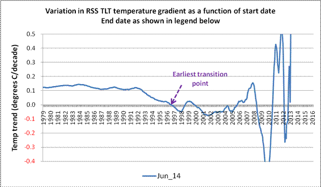
Fig 2: Variation in temperature gradient. End date June 2014

On the above chart (Fig 2), it can clearly be seen that, after about 13 or 14 years of stability, the rate of change of temperature starts to oscillate wildly as one looks further to the right. Mr Monckton’s approach has been simply to note the earliest transition point, and then declare that there has been no warming since that date. One could, if being generous, describe this as a somewhat naïve interpretation, although others may feel that a stronger adjective would be more appropriate. However, given his classical education, it is difficult to say why he does not seem to comprehend the difference between veracity and verisimilitude. (The latter being the situation when something merely has the appearance of being true – as opposed to actually being the real thing.)

Fig 2 is made up from 425 discrete gradient values, each generated (in this case) using Excel’s SLOPE function. Of these, 122 are indeed below the horizontal axis, and can therefore be viewed as demonstrating a negative (i.e. cooling) trend. However, that also means that 70% show a trend that is positive. Indeed, if one performs a simple arithmetic average across all 425 data points, the integration thus obtained is 0.148 degrees Celsius per decade.

(In the spirit of honesty and openness, it must of course be pointed out that the aggregated warming trend of 0.148 degrees Celsius/decade thus obtained has just about the same level of irrelevance as Mr Monckton’s “no warming since mm/yy” claim. Nether has any real physical meaning, as, once one gets closer to the end date(s), the values can swing wildly from one month to the next. In Fig 2, the sign of the temperature trend changes 8 times from 1996 onwards. A similar chart created at the time of his December 2013 article would have had no fewer than 13 sign changes over a similar period. This is because the period in question is too short for the warming signal to unequivocally emerge from the noise.)

As one adds more and more data, a family of curves gradually builds up, as shown in Fig 3a below.

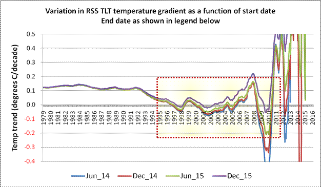
Fig 3a: Family of curves showing how end-date also affects temperature gradient

It should be clear from Fig 3a that each temperature gradient curve migrates upwards (i.e. more warming) as each additional 6-month block of data comes in. This is only to be expected, as the impact of isolated events – such as the temperature spike created by the 1997/98 El Niño – gradually wane as they get diluted by the addition of further data. The shaded area in Fig 3a is expanded below as Fig 3b in order to make this effect more obvious.

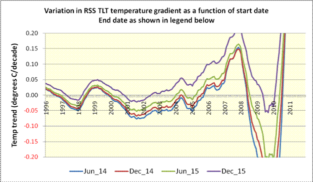
Fig 3b: Expanded view of curve family

By the time we are looking at an end date of December 2015, the relevant curve now consists of 443 discrete values, of which just 39, or 9%, are in negative territory. Even if one only considers values to the right of the initial transition point, a full 82% of these are positive. The quality of Mr Monckton’s prize-winning sausages is therefore revealed as being dubious in the extreme. (The curve has not been displayed, but the addition of a single extra month – January 2016 – further reduces the number of data points below the zero baseline to just 26, or 6%.) To anyone tracking this, there was only ever going to be one outcome, eventually, the curve was going to end up above the zero baseline. The ongoing El Niño conditions have merely served to hasten the inevitable.

With the release of the February 2016 data from RSS, this is precisely what happened. We can now add a fifth curve using the most up-to-date figures available at the time of writing. This is shown below as Fig 4.

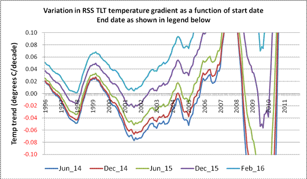
Fig 4: Further expansion of curve families incorporating latest available data (Feb 2016)

As soon as the latest (Feb 2016) data is added, the fifth member of the curve family (in Fig 4) no longer intersects the horizontal axis – anywhere. When this happens, all of Mr Monckton’s various sausages reach their collective expiry date, and his entire fantasy of “no global warming since mm/yy” simply evaporates into thin air.

Interestingly, although Mr Monckton chooses to restrict his “analysis” to only the Lower Troposphere Temperatures produced by Remote Sensing Systems (RSS), another TLT dataset is available from the University of Alabama in Huntsville (UAH). Now, this omission seems perplexing, as Mr Monckton took time to emphasise the reliability of the satellite record in his article dated May 2014.

In his Technical Note to this article, Mr Monckton tells us…

The satellite datasets are based on measurements made by the most accurate thermometers available – platinum resistance thermometers, which not only measure temperature at various altitudes above the Earth’s surface via microwave sounding units but also constantly calibrate themselves by measuring via spaceward mirrors the known temperature of the cosmic background radiation, which is 1% of the freezing point of water, or just 2.73 degrees above absolute zero. It was by measuring minuscule variations in the cosmic background radiation that the NASA anisotropy probe determined the age of the Universe: 13.82 billion years.

Now, that certainly makes it all sound very easy. It’s roughly the metaphorical equivalent of the entire planet being told to drop its trousers and bend over, as the largest nurse imaginable approaches, all the while gleefully clutching at a shiny platinum rectal thermometer. Perhaps a more balanced perspective can be gleaned by reading what RSS themselves have to say about the difficulties involved in Brightness Temperature measurement.

When one looks at Mr Monckton’s opening sentence referring to “the most accurate thermometers available”, one would certainly be forgiven for thinking that there must perforce be excellent agreement between the RSS and UAH datasets. This meme, that the trends displayed by the RSS and UAH datasets are in excellent agreement, is one that appears to be very pervasive amongst those who regard themselves as climate change sceptics. Sadly, few of these self-styled sceptics seem to understand the meaning behind the motto “Nullius in verba”.

Tellingly, this “RSS and UAH are in close agreement” meme is in stark contrast to the views of the people who actually do that work for a living.

Carl Mears (of RSS) wrote an article back in September 2014 discussing the reality – or otherwise – of the so-called “Pause”. In the section of this article dealing with measurement errors, he wrote that …

 A similar, but stronger case can be made using surface temperature datasets, which I consider to be more reliable than satellite datasets (they certainly agree with each other better than the various satellite datasets do!) [my emphasis]

The views of Roy Spencer from UAH concerning the agreement (or, more accurately, the disagreement) between the two satellite datasets must also be considered. Way back in July 2011, Dr Spencer wrote

… my UAH cohort and boss John Christy, who does the detailed matching between satellites, is pretty convinced that the RSS data is undergoing spurious cooling because RSS is still using the old NOAA-15 satellite which has a decaying orbit, to which they are then applying a diurnal cycle drift correction based upon a climate model, which does not quite match reality.

So there we are, Carl Mears and Roy Spencer, who both work independently on satellite data, have views that are somewhat at odds with those of Mr Monckton when it comes to agreement between the satellite datasets. Who do we think is likely to know best?

The closing sentence in that paragraph from the Technical Note did give rise to a wry smile. I’m not sure what relevance Mr Monckton thinks there is between global warming and a refined value for the Hubble Constant, but, for whatever reason, he sees fit to mention that the Universe was born nearly 14 billion years ago. The irony of Mr Monckton mentioning this in an article which treats his target audience as though they were born yesterday appears to have passed him by entirely.

Moving further into Mr Monckton’s Technical Note, the next two paragraphs basically sound like a used car salesman describing the virtues of the rust bucket on the forecourt. Instead of trying to make himself sound clever, Mr Monckton could simply have said something along the lines of … “If you want to verify this for yourself, it can easily be done by simply using the SLOPE function in Excel”. Of course, Mr Monckton might prefer his readers not to think for themselves.

The final paragraph in the Technical Note reads as follows…

Dr Stephen Farish, Professor of Epidemiological Statistics at the University of Melbourne, kindly verified the reliability of the algorithm that determines the trend on the graph and the correlation coefficient, which is very low because the data are highly variable and the trend is flat.

Well, this is an example of the logical fallacy known as “Argument from Authority” combined with a blatant attempt at misdirection. The accuracy of the “… algorithm that determines the trend …” has absolutely nothing to do with Mr Monckton’s subsequent interpretation of the results, although that is precisely what the reader is meant to think. The good professor may well be seriously gifted at statistics, but that doesn’t mean he speaks with any authority about atmospheric science or about satellite datasets.

Also, for the sake of the students at Melbourne University, I would hope that Mr Monckton was extemporizing at the end of that paragraph. It is simply nonsense to suggest that the “flatness” of the trend displayed in his Fig 1 is in any way responsible for the trend equation also having an R2 value of (virtually) zero. The value of the coefficient of determination (R2) ranges from 0 to 1, and wildly variable data can most certainly result in having a value of zero, or thereabouts, but the value of the trend itself has little or no bearing upon this.

The phraseology used in the Technical Note would appear to imply that, as both the trend and the coefficient of determination are effectively zero, this should be interpreted as two distinct and independent factors which serve to corroborate each other. Actually, nothing could be further from the truth.

The very fact that the coefficient of determination is effectively zero should be regarded as a great big blazing neon sign which says “the equation to which this R2 value relates should be treated with ENORMOUS caution, as the underlying data is too variable to infer any firm conclusions”.

To demonstrate that a (virtually) flat trend can have an R2 value of 1, anyone can try inputting the following numbers into a spreadsheet …

10.0 10.00001 10.00002 10.00003 etc.

Use the Auto Fill capability to do this automatically for about 20 values. The slope of this set of numbers is a mere one part in a million, and is therefore, to all intents and purposes, almost perfectly is flat. However, if one adds a trend line and asks for the R2 value, it will return a value of 1 (or very, very close to 1). (NB When I tried this first with a single recurring integer – i.e. absolutely flat – Excel returned an error value. That’s why I suggest using a tiny increment, such as the 1 in a million slope mentioned above.)

Enough of the Technical Note nonsense, let’s looks at the UAH dataset as well. Fig 5 (below) is a rework of the earlier Fig 2, but this time with the UAH dataset added, as well as an equally weighted (RSS+UAH) composite.

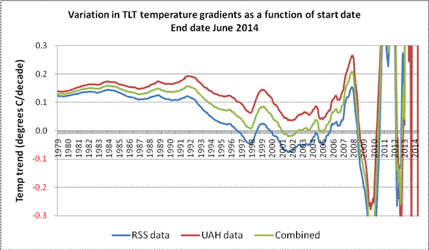
Fig 5: Comparison between RSS and UAH (June 2014)

The difference between the RSS and UAH results makes it clear why Mr Monckton chose to focus solely on the RSS data. At the time of writing this present article, the RSS and UAH datasets each extended to February 2016, and Fig 6 (below) shows graphically how the datasets compare when that end date is employed.

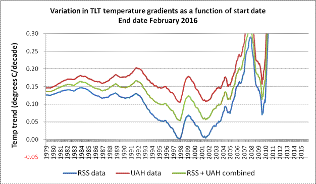
Fig 6: Comparison between RSS and UAH (Feb 2016)

In his sausage with the November 2015 sell-by-date, Mr Monckton assured his readers that “…The UAH dataset shows a Pause almost as long as the RSS dataset.

Even just a moment or two spent considering the UAH curves on Fig 5 (June 2014) and then on Fig 6 (February 2016) would suggest precisely how far that claim is removed from reality. However, for those unwilling to put in this minimal effort, Fig 7 is just for you.

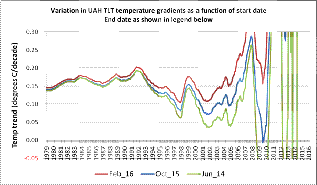
Fig 7: UAH TLT temperatures gradients over three different end dates.

From the above diagram, it is rather difficult to see any remote justification for Mr Monckton’s bizarre assertion that “…The UAH dataset shows a Pause almost as long as the RSS dataset.

Moving on, it is clear that, irrespective of the exact timeframe, both the datasets exhibit a reasonably consistent “triple dip”. To understand the cause(s) of this “triple dip” in the above diagrams (at about 1997, 2001 and 2009), one needs to look at the data in the usual anomaly format, rather than in gradient format used in Figs 2 – 7.

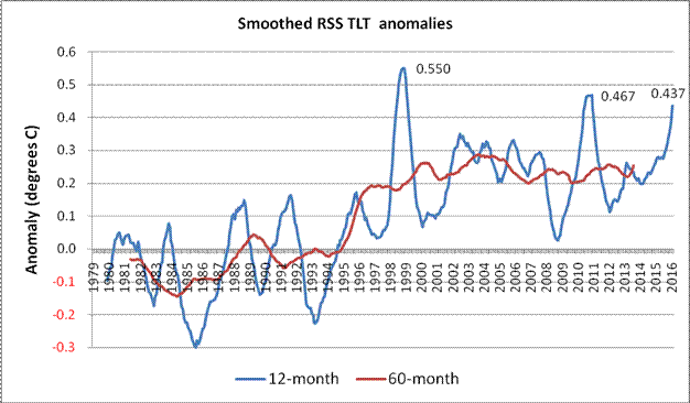
Fig 8: RSS TLT anomalies smoothed over 12-month and 60-month periods

The monthly data looks very messy on a chart, but the application of 12-month and 60-month smoothing used in Fig 8 perhaps makes some details easier to see. The peaks resulting from the big 1997/98 El Niño and the less extreme 2009/10 event are very obvious on the 12-month data, but the impact of the prolonged series of 4 mini-peaks centred around 2003/04 shows up more on the 60-month plot. At present, the highest 60-month rolling average is centred near this part of the time series. (However, that may not be the case for much longer. If the next few months follow a similar pattern to the 1997/98 event, both the 12- and 60-month records are likely to be surpassed. Given that the March and April RSS TLT values recorded in 2015 were the two coolest months of that year, it is highly likely that a new rolling 12-month record will be set in April 2016.)

Whilst this helps explain the general shape of the curve families, it does not explain the divergence between the RSS and the UAH data. To show this effect, two approaches can be adopted: one can plot the two datasets together on the same chart, or one can derive the differences between RSS and UAH for every monthly value and plot that result.

In the first instance, the equivalent UAH rolling 12- and 60-month values have effectively been added to the above chart (Fig 8), as shown below in Fig 9.

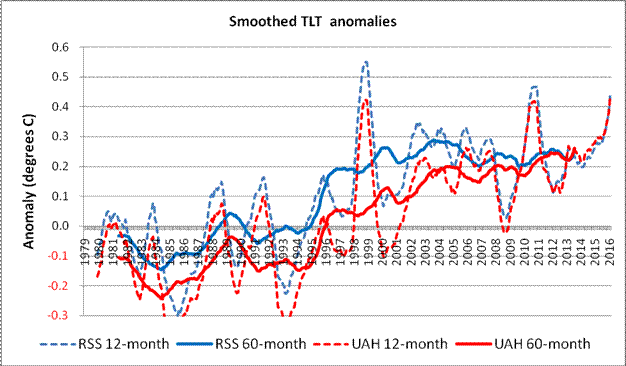
Fig 9: RSS and UAH TLT anomalies using 12- and 60-month smoothing

On this chart (Fig 9) it can be seen that the smoothed anomalies start a little way apart, diverge near the middle of the time series, and then gradually converge as one looks toward the more recent values. Interestingly, although the 60-month peak at about 2003/04 in the RSS data is also present in the UAH data, it has long since been overtaken.

The second approach would involve subtracting the UAH monthly TLT anomalies figures from the RSS equivalents. The resulting difference values are plotted on Fig 10 below, and are most revealing. The latest values on Figs 9 and 10 are for February 2016.

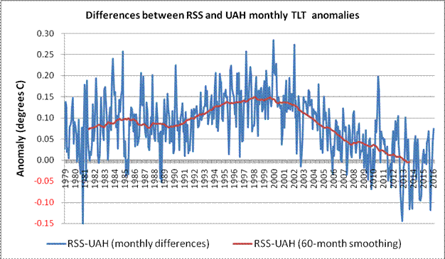
Fig 10: Differences between RSS and UAH monthly TLT values up to Feb 2016

Even without the centred 60-month smoothed average, the general shape emerges clearly. The smoothed RSS values start off about 0.075 Celsius above the UAH values, but by about 1999 or 2000, this delta has risen to +0.15 Celsius. It then begins a virtually monotonic drop such that the 6 most recent rolling 60-month values have gone negative.

NB It is only to be expected that the dataset comparison begins with an offset of this magnitude. The UAH dataset anomalies are based upon a 30-year meteorology stretching from 1981 – 2010. However, RSS uses instead a 20-year baseline running from 1979 – 1998. The mid points of the two baselines are therefore 7 years apart. Given that the overall trend is currently in the order of 0.12 Celsius per decade, one would reasonably expect the starting offset to be pretty close to 0.084 Celsius. The actual starting point (0.075 Celsius) was therefore within about one hundredth of a degree Celsius from this figure.

Should anyone doubt the veracity of the above diagram, hereis a copy of something similar taken from Roy Spencer’s web pages. Apart from the end date, the only real difference is that whereas Fig 9 has the UAH monthly values subtracted from the RSS equivalent, Dr Spencer has subtracted the RSS data from the UAH equivalent, and has applied a 3-month smoothing filter. This is reproduced below as Fig 11.

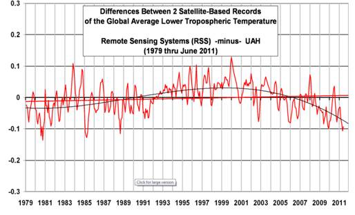
Fig 11: Differences between UAH and RSS (copied from Dr Spencer’s blog)

This actually demonstrates one of the benefits of genuine scepticism. Until I created the plot on Fig 10, I was sure that the 97/98 El Niño was almost entirely responsible for the apparent “pause” in the RSS data. However, it would appear that the varying divergence from the equivalent UAH figures also has a very significant role to play. Hopefully, the teams from RSS and UAH will, in the near future, be able to offer some mutually agreed explanation for this divergent behaviour. (Although both teams are about to implement new analysis routines – RSS going From Ver 3.3 to Ver 4, and UAH going from Ver 5.6 to Ver 4.0 – mutual agreement appears to be still in the future.)

Irrespective of this divergence between the satellite datasets, the October 2015 TLT value given by RSS was the second largest in that dataset for that month. That was swiftly followed by monthly records for November, December and January. The February value went that little bit further and was the highest in the entire dataset. In the UAH TLT dataset, September 2015 was the third highest for that month, with each of the 5 months since then breaking the relevant monthly record. As with its RSS equivalent, the February 2016 UAH TLT figure was the highest in the entire dataset. In fact, the latest rolling 12-month UAH TLT figure is already the highest in the entire dataset. This would certainly appear to be strange behaviour during a so-called pause.

As sure as the sun rises in the east, these record breaking temperatures (and their effect on temperature trends) will be written off by some as merely being a consequence of the current El Niño. It does seem hypocritical that these people didn’t feel that a similar argument could be made about the 1997/98 event. An analogy could be made concerning the measurement of Sea Level Rise. Imagine that someone – who rejects the idea that sea level is rising – starts their measurements using a high tide value, and then cries foul because a subsequent (higher) reading was also taken at high tide.

This desperate clutching of straws will doubtless continue unabated, and a new “last, best hope” has already appeared in guise of Solar Cycle 25. Way back in 2006, an article by David Archibald appeared in Energy & Environment telling us how Solar Cycles 24 & 25 were going to cause temperatures to plummet. In the Conclusion to this paper, Mr Archibald wrote that …

A number of solar cycle prediction models are forecasting weak solar cycles 24 and 25 equating to a Dalton Minimum, and possibly the beginning of a prolonged period of weak activity equating to a Maunder Minimum. In the former case, a temperature decline of the order of 1.5°C can be expected based on the temperature response to solar cycles 5 and 6.

Well, according to NASA, the peak for Solar Cycle 24 passed almost 2 years ago, so it’s not looking too good at the moment for that prediction. However, Solar Cycle 25 probably won’t peak until about 2025, so that will keep the merchants of doubt going for a while.

Meanwhile, back in the real world, it is very tempting to make the following observations …

  • The February TLT value from RSS seems to have produced the conditions under which certain allotropes of the fabled element known as Moncktonite will spontaneously evaporate, and …
  • If Mr Monckton’s sausages leave an awfully bad taste in the mouth, it could be due to the fact that they are full of tripe.

Inevitably however, in the world of science at least, those who seek to employ misdirection and disinformation as a means to further their own ideological ends are doomed to eventual failure. In the closing paragraph to his “Personal
observations on the reliability of the Shuttle
”, the late, great Richard Feynman used a phrase that should be seared into the consciousness of anyone writing about climate science, especially those who are economical with the truth…

For a successful technology, reality must take precedence over public relations, for nature cannot be fooled.

Remember that final phrase – “nature cannot be fooled”, even if vast numbers of voters can be!

Watts Up With DMI Arctic Sea Ice Extent?

When I pose that question I’m not referring to the Danish Meteorological Institute’s long “deprecated” 30% concentration threshold Arctic sea ice extent metric so much as the reaction to its demise amongst the more “skeptical” of we cryospheric bloggers. Here once again is the “controversial” graph in question, archived from the start of the year:

DMI-15-2016-01-04

No sooner had Paul Homewood moved on from that topic to finally reproduce on his blog an NSIDC Arctic sea ice graph I first brought to his attention last spring than across the Atlantic in the good ‘ol US of A a certain Mr. Anthony Watts suddenly loudly proclaims that he “tends to agree” with Mr. Homewood’s assertion that:

There has been so much skulduggery going on in the climate establishment in recent years that it is hard to avoid the conclusion that this graph has been withdrawn simply because it gives the “wrong” results.

Given the actual facts of the matter this is peculiar enough, but then things get positively surreal. Regular readers will realise that up here in the penthouse suite at the pinnacle of the tallest of the Great White Con Ivory Towers we pride ourselves on our surreal sensibilities. Today though, we are forced to admit that WUWT has beaten us at our own game. Whilst we were conducting a perfectly sane interview with one of the world’s top sea ice scientists Tony was concocting these perfectly formed surrealist fantasies.

In his update 1 to this already nonsensical story Anthony assures us that:

The typical haters, such as Neven Acropolis, are making claims in comments that I see this as some sort of “conspiracy”. I do not and any such claim is false and political in nature.

Mr. Watts is evidently a big fan of William Burroughs, and has used his celebrated “cut-up” technique to transform “Skulduggery going on in the climate establishment” into “magnets cued she got on the inimitably ginger skull” which is obviously not even slightly conspiratorial.

Let’s move swiftly on to update 2, wherein we are told:

DMI has an entire page dedicated to the use of the 30% concentration value that is still operational!

However if you read the small print on Anthony’s accompanying image it says that:

The maps are additionally overlayed with the corresponding multi-year monthly mean of the periods 1978-2014.

and if you click the accompanying link you will discover that there is no way on Earth to persuade the DMI web site to display “operational” data from 2015, let alone 2016.

Whilst we eagerly await the no doubt imminent arrival of What’s up with that Watts DMIgate update 3 we will leave you with some words of wisdom from Dr. Walt Meier of NASA, the aforementioned top sea ice scientist, who informed us earlier today that:

Regarding DMI, the issue seems quite simple. The 30% plot is an older version that they stopped supporting as they transitioned to the 15% plot.

DMI, MASIE and the Sea Ice Index – An Interview With Walt Meier

For some reason best known to himself Anthony Watts has jumped on the “DMIGate” bandwagon started by Paul Homewood over on this side of the Atlantic a few days ago. In his latest article Mr. Watts quotes with approval the “Not A Lot Of People Know That” article which we have already covered in some depth.

Here yet again is one of my comments that recently ended up on the NALOPKT cutting room floor:

2016-02-21_1811-NALOPKT

You will note that I was suggesting that Ron Clutz’s extremely selectively interpretation of some of Walt Meier’s academic papers left a lot to be desired. Particularly given the additional fuel added to the “skulduggery” fire by the Watts Up With That article it seemed sensible to phone up NASA and ask Walt for his views on the second hottest Arctic sea ice topic on the planet at the moment, according to Messrs. Clutz and Homewood at least. That is the relative merits of Multisensor Analyzed Sea Ice Extent (MASIE for short) versus the National Snow and Ice Data Center’s Sea Ice Index (SII for short) for determining Arctic sea ice trends.

According to the NSIDC:

MASIE sea ice products are developed from National Ice Center (NIC for short) data with support from the U.S. Navy and from NOAA. MASIE is hosted by NOAA@NSIDC.

whereas:

The Sea Ice Index provides a quick look at Arctic- and Antarctic-wide changes in sea ice. It is a source for consistent, up-to-date sea ice extent and concentration images and data values from November 1978 to the present.

As luck would have I managed to get through to Walt on my second attempt, and he graciously agreed to be interviewed at extremely short notice. He told me that whilst he now worked at NASA he used to be at the NSIDC, and still collaborated with them. Here are the edited highlights of his thoughts on “MASIE v SII”:

MASIE repackages data from the NIC, and incorporates an ice edge hand drawn by analysts working with whatever satellite data they have available at the time. It is an “operational” product designed to produce a “best effort” ice edge each day, based on whatever data may be available at the time.

Visual data is obviously not available in winter, and the ice edge is often obscured by clouds in summer. Synthetic Aperture Radar can “see in the dark” and through clouds, but suffers from different limitations. The whole of the Arctic isn’t covered every day for example. In addition, and unlike the SII, data from different satellite sensors is incorporated which means there are inevitably inconsistencies from day to day and from year to year. There is also an element of “human subjectivity” because different analysts are working with different sources of data from one day to the next. Since the quantity and quality of data varies the time series will not be consistent over time.

On the other hand the SII was designed to use a consistent methodology over a long period of time using a single type of sensor. 100% automatically processed passive microwave data is the “gold standard” when it comes to determining sea ice trends. It is subject to some biases and thus is not necessarily as accurate on a given day as MASIE. However, the biases are consistent over time, so the time series will be consistent over time. This means that year-to-year comparisons and trend estimates will be more accurate in the passive microwave data than in MASIE.

So there you have it. If you’re on the bridge of a vessel sailing in Arctic waters then MASIE is the right tool for the job. If on the other hand you’re sat in front of a computer trying to get the best estimate of trends in Arctic sea ice extent then the Sea Ice Index is what you’ll grab from your toolkit.

Having had a chance to examine the “evidence” of DMI “skulduggery” presented by Messrs. Watts and Homewood, Walt sent me a follow up email. Here is what it says:

Regarding DMI, the issue seems quite simple. The 30% plot is an older version that they stopped supporting as they transitioned to the 15% plot. I don’t know specifically why the 30% plot went awry, but there is generally automatic quality control done to make sure the final results are accurate and consistent. If such QC is not done, a lot of incorrect values can occur. I suspect that since the older version was no longer supported, the QC wasn’t being watched and something went wrong that they didn’t bother to fix (or maybe didn’t even notice) because the new 15% version is the official DMI output.

Not a lot of people know that, because Watts, Homewood et al. have developed the nasty habit of “snipping” comments to that effect as and when the mood takes them, which based on my own experience seems to be remarkably often in this day and age.

2015 Really Is “The Warmest Year in Modern Record”!

Our regular reader(s) may recall that this time last year we took umbrage at an article by David Rose in the Mail on Sunday about the joint NASA/NOAA press briefing outlining their findings about global surface temperatures in 2014.

We’ve been discussing Mr. Rose’s recent misleading “Tweets” about the Arctic with him:

As a consequence we also found ourselves in conversation with Gavin Schmidt of NASA about this year’s NASA/NOAA press briefing about global surface temperatures in 2015, which takes place on January 20th. Pencil it into your diary:

Climate experts from NASA and the National Oceanic and Atmospheric Administration (NOAA) will discuss the release of new data on 2015 global temperatures, and the most important weather and climate events of the year, during a media teleconference at 11 a.m. EST Wednesday, Jan. 20.

The teleconference panelists are:

Gavin Schmidt, director of NASA’s Goddard Institute for Space Studies in New York
Thomas R. Karl, director of NOAA’s National Centers for Environmental Information in Asheville, North Carolina, and chair of the Subcommittee on Global Change Research for the U.S. Global Change Research Program in Washington

Media can participate in the teleconference by calling 888-790-1804 (toll-free in the United States and Canada) or 415-228-4885 (international) and use the passcode “climate.”

Audio of the briefing, as well as supporting graphics, will stream live.

Whilst we wait with bated breath for the NASA/NOAA announcement, here’s how the Gavin, David & Snow show has been going over on Twitter:


You will note from the exchange on Twitter that the Berkeley Earth Surface Temperature project are one of the organisations that have already declared 2015 “The Warmest Year in the Modern Record”, which brings me to the Arctic connection. Tamino explains over at “Open Mind”, in an article entitled “Hottest Year On Record“:

When it comes to global temperature over land and sea, Berkeley produces two versions, different in the way they treat areas covered with sea ice. Version 1 uses air temperature estimates for sea-ice covered regions, version 2 uses ocean temperature estimates.

and quotes BEST as follows:

For most of the ocean, sea-surface temperatures are similar to near-surface air temperatures; however, air temperatures above sea ice can differ substantially from the water below the sea ice. The air temperature version of this average shows larger changes in the recent period, in part this is because water temperature changes are limited by the freezing point of ocean water. We believe that the use of air temperatures above sea ice provides a more natural means of describing changes in Earth’s surface temperature.

As Tamino puts it:

Let’s not keep you in suspense any longer. Here are annual averages through 2015 (which is now complete) according to version 1:

2015-berk1

Here it is according to version 2:

2015-berk2

Any way you look at it, 2015 is the hottest. Any way you look at it, there was no “pause” in global temperature.

[Edit – 17:30 UTC on January 20th 2016]

The joint NASA/NOAA media briefing on 2015 global average surface temperatures has just finished. The recording of the event is due to go online “in 2 hours” or so from:

http://www.noaanews.noaa.gov/advisories/011516-advisory-noaa-nasa-to-announce-official-analyses-of-2015-global-temperature-climate-conditions.html

You can get a good flavour things by taking a look at the second half of the Twitter “Storify” above. This one sums things up:

Whilst we all wait for the recording to emerge, you can download the slides for the briefing from:

http://www.nasa.gov/sites/default/files/atoms/files/noaa_nasa_global_analysis_2015.pdf

and here’s a video summary NASA have released:

Note too that the UK Met Office released their numbers this afternoon also. Here’s how they look:

and here’s the Met Office’s video in which Peter Stott explains their conclusion that:

2015 – Warmest year on record globally

I waited patiently in the NASA/NOAA queue to ask some Arctic related questions, but never received the call. I’ll let you know when I receive the promised answers by email.

New Calving of the Zachariae Isstrom Glacier

The Zachariæ Isstrøm glacier in North East Greenland is in the news at the moment. Here’s a recent article from The Guardian for example, which states that:

A major glacier in Greenland that holds enough water to raise global sea levels by half a metre has begun to crumble into the North Atlantic Ocean, scientists say. The calving of the glacier into chunks of floating ice will set in train a rise in sea levels that will continue for decades to come, the US team warns.

“Even if we have some really cool years ahead, we think the glacier is now unstable,” said Jeremie Mouginot at the University of California, Irvine. “Now this has started, it will continue until it retreats to a ridge about 30km back which could stabilise it and perhaps slow that retreat down.”

Mouginot and his colleagues drew on 40 years of satellite data and aerial surveys to show that the enormous Zachariae Isstrom glacier began to recede three times faster from 2012, with its retreat speeding up by 125 metres per year every year until the most recent measurements in 2015.

The same records revealed that from 2002 to 2014 the area of the glacier’s floating shelf shrank by a massive 95%, according to a report in the journal Science. The glacier has now become detached from a stabilising sill and is losing ice at a rate of 4.5bn tonnes a year.

Eric Rignot, professor of Earth system science at the University of California, Irvine, said that the glacier was “being hit from above and below”, with rising air temperatures driving melting at the top of the glacier, and its underside being eroded away by ocean currents that are warmer now than in the past.

“The glacier is now breaking into bits and pieces and retreating into deeper ground,” he said. The rapid retreat is expected to continue for 20 to 30 more years, until the glacier reaches another natural ledge that slows it down.

The Guardian article includes a picture of Zachariæ Isstrøm, along with much of the rest of North East Greenland. Here it is again, together with a helpful annotation revealing the location of the calving face of Zachariæ Isstrøm in amongst all the snow and ice:

zach-guardian

That’s still not really much help when it comes to visualising the “retreat speeding up by 125 metres per year”, so here’s a closer look at Zachariae Isstrom using an image prepared by Espen Olsen for the Arctic Sea Ice Forum, which is based on a Landsat 8 satellite image from September 2014:

Retreat of the calving face of the Zachariae Isstrøm glacier between 2009 and 2015

North East Greenland is in the dark at the moment, but if you want to take a closer look at recent changes to Zachariæ Isstrøm for yourself you can do so with the aid of NASA’s EOSDIS Worldview web site, which allows you to scroll through images from both the Aqua and Terra satellites. Here’s one from August 26th 2015:

NASA Worldview “true-color” image of the Zachariae Isstrøm glacier on August 26th 2015, derived from the MODIS sensor on the Aqua satellite

Our headline for today announces that yet another large chunk of ice has just detached itself from Zachariæ Isstrøm. You may wonder how we can be so sure of that when it’s dark in North East Greenland? That’s because yet another satellite can “see” in the dark, using synthetic aperture radar. Here’s an animation prepared earlier today by “Wipneus” using data from the European Space Agency’s Sentinel 1A satellite, once again for the Arctic Sea Ice Forum:

Animated comparison of Sentinel 1A visualisations of the Zachariae Isstrøm calving face on 4th and 16th November 2015

Can you spot “The new iceberg [that] seems to lie on its side”?

The conclusion to all this frantic activity, according to Mouginot, Rignot et al. at least, is that:

The Zachariæ Isstrøm / Nioghalvfjerdsfjorden sector is one of three major marine-based basins in Greenland along with the Jakobshavn Isbræ and Petermann–Humboldt glaciers, each holding a 0.6-m sea-level equivalent. Jakobshavn Isbræ started a rapid retreat (18 km in 2001-2015) following the collapse of its ice shelf and has undergone massive calving events since 2010. The central channel of the Petermann ice shelf lost 250 m of ice in 2002-2010, and the ice front retreated 33 km in 2010-2012. The Nioghalvfjerdsfjorden ice shelf will become vulnerable to break up in the near future if thinning continues. These observations combined suggest that all three major marine-based basins are undergoing significant changes at present. Jakobshavn Isbræ and Zachariæ Isstrøm have already transitioned to tidewater glacier regime, with increased calf-ice production and ice melting by the ocean. The retreat of these marine-based sectors is likely to increase sea-level rise from Greenland for decades to come.

Does a Lie Told Often Enough Become the Truth?

This morning “Steven Goddard” quotes Lenin and Hitler with apparent approval. In an article entitled “Today’s Featured Climate Criminals – The Guardian” he closes with the following quotations:

“A lie told often enough becomes the truth”
– Vladimir Lenin

“The most brilliant propagandist technique will yield no success unless one fundamental principle is borne in mind constantly and with unflagging attention. It must confine itself to a few points and repeat them over and over. Here, as so often in this world, persistence is the first and most important requirement for success”
– Adolf Hitler

The few points about the Arctic that Tony Heller repeats over and over look like this today:

The Guardian reports that Arctic ice is melting “faster and earlier”

Arctic ice melting faster and earlier as scientists demand action | Environment | The Guardian

Arctic sea ice is melting very slowly, and is nearing a mid-summer high for the past decade.

unRealScience-DMI-20150623

Ocean and Ice Services | Danmarks Meteorologiske Institut

Arctic sea ice looked like this on June 20 – nothing like the fake picture in their May 5 article.

unRealScience-Ice-20150623

The Greenland melt season started more than a month late, and has seen below normal melt every day this year.

unRealScience-Grelyenland-20150623

Greenland Ice Sheet Surface Mass Budget: DMI

The Guardian report cited by Steve/Tony does in actual fact date from May 5th 2015. For an up to date alternative viewpoint see for example:

DMI Arctic sea ice volume on June 22nd 2015

NASA Worldview “true-color” image of broken ice north of the East Siberian Sea on June 22nd 2015, derived from bands 1, 4 and 3 of the MODIS sensor on the Aqua satellite
NSIDC Greenland melt area graph on June 21st 2015

New Antarctic Sea Ice Resources

In the Arctic the refreeze is slowing down as the March maximum extent approaches. Meanwhile in the southern hemisphere Antarctic sea ice extent has taken a tumble as the annual minimum extent approaches.

Over the long cold Arctic winter “Wipneus” of ArctischePinguin fame has been porting his northern hemisphere regional sea ice area/extent methodology to cover the South Pole as well. We are pleased to be able to reveal the fruits of his labours on our new regional Antarctic Sea Ice Graphs page. The ultimate source of the information is the University of Hamburg’s sea ice concentration data based on a 3.125 km grid that uses data from the from the AMSR2  instrument on board the Japan Aerospace Exploration Agency’s SHIZUKU satellite. Here’s an overview of Antarctic sea ice area:

2015-02-07-Ant-Area and here’s a close up on the sea ice extent in the Bellingshausen and Amundsen Seas region, where what sea ice there is helps buttress the West Antarctic Ice Sheet:

2015-02-07-West-Extent

In future we will also be bringing you satellite images from Antarctica. By way of example, here’s the latest “Shock News!!!” from the Antarctic, courtesy of LandSat 8:

I
NASA report that:

While large icebergs calve regularly from fast-flowing ice shelves in West Antarctica, the coast of cooler, drier East Antarctica tends to be less active. That made it a mild surprise when a 70-square-kilometer chunk of ice broke off from the King Baudouin Ice Shelf in January 2015. The last time that part of King Baudouin calved such a large iceberg was in the 1960s.

and you can track the current position of the latest large chunk of ex ice shelf on their WorldView web site:

The recently calved King Baudouin Ice Shelf on February 3rd 2015

Thanks also to “Arcticio” from the Arctic Sea Ice Blog who pointed me in the direction of PolarView, where it was remarkably easy to locate this Sentinel-1A synthetic aperture radar image of the large iceberg in question on January 30th 2015:

RoiBaudouin-600