Tag Archives: Worldview

Facts About the Arctic in January 2022

2021 has been and gone, so first of all may I wish all our readers a very Happy New Year.

Sadly it’s not been a happy start to 2022 for the inhabitants of Boulder, Colorado, home of the National Snow and Ice Data Center. According to the Denver Post:

The Marshall fire destroyed an estimated 991 homes in Boulder County, damaged 127 more and may have killed three people, Sheriff Joe Pelle said Saturday afternoon.

Pelle added that the cause of the fire — the most damaging in Colorado history — remains under investigation, and confirmed that sheriff’s officials have served a search warrant on at least one property based on a tip.

Currently, two people are missing in Superior and another is missing in the Marshall area, Pelle said. All three are feared dead as each of their homes was lost to the fire, the sheriff said…

So far, officials say Thursday’s wildfire — exacerbated by 100-mph winds — burned more than 6,000 acres across Boulder County.

The fire destroyed 553 homes in Louisville, damaging 45, Pelle said Saturday. It also destroyed 332 homes in Superior, damaging 60 in that town, and destroyed 106 homes in unincorporated Boulder County, damaging 22…

Officials first thought downed power lines sparked the fire, but have been unable to confirm its origin. The abnormally dry conditions led to what is now the most destructive wildfire in Colorado history.

Moving north to examine snow and ice data from the Arctic, let’s start 2022 in traditional fashion with a look at high resolution AMSR2 area and extent:
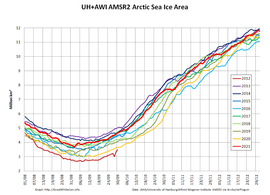
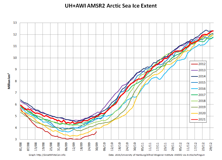
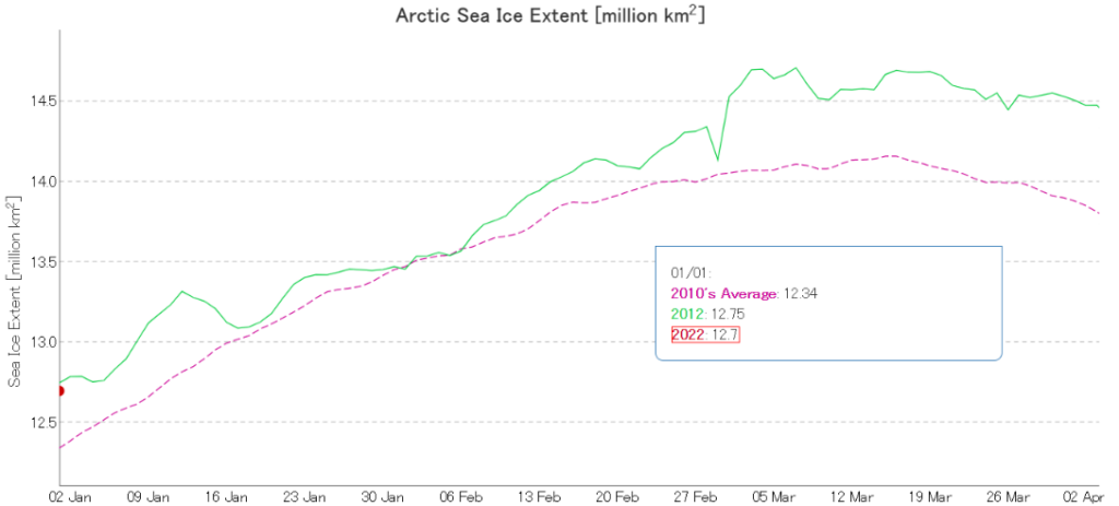
Both metrics are now near the upper boundary of the last 10 years’ range. The AMSR2 instrument wasn’t launched into orbit until summer 2012, but according to both JAXA and NSIDC data extent on January 1st 2022 is almost identical to the same date in 2012. Regular readers will recall that year went on to produce the lowest annual minimum extent in the satellite era despite recording the highest annual maximum in the decade of the 2010s:
Note that sea ice volume tells a rather different story. Here’s the latest AWI CryoSat-2/SMOS volume graph:

The current near real time data is likely to be revised upwards slightly when the final reanalysis is complete, but even so volume seems likely to remain in the lower half of the recent range at the end of 2021.

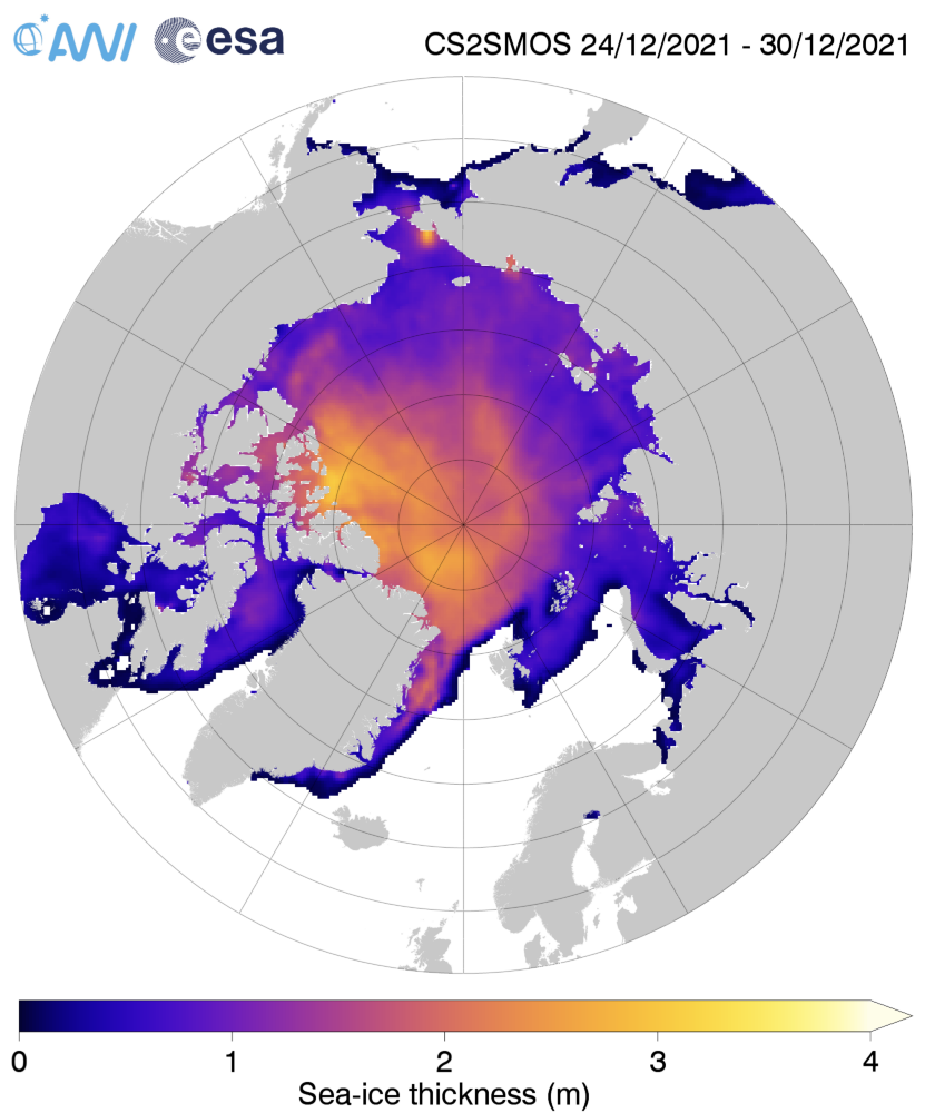
Here too is the AWI Arctic sea ice thickness map:
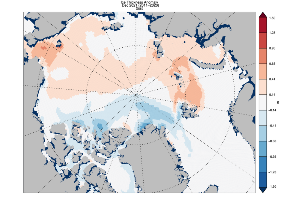
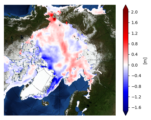
together with the thickness anomaly map from the Finnish Meteorological Institute:

Once again the ice in the so called “last ice area” north of Greenland and Ellesmere Island is thinner than usual, as is the ice in the Fram Strait and East Greenland Sea.

[Edit – January 11th]

As has been pointed out below, the Polar Science Center has now released the PIOMAS volume data for December 2021:

Average Arctic sea ice volume in December 2021 was 13,300 km3. This value is the 9th lowest on record for December,  about  2100 km3 above the  record set in 2016.   Monthly  ice volume was 51% below the maximum in 1979 and 37% below the mean value for 1979-2020. Average December 2021 ice volume was  1.2  standard deviations above the 1979-2020 trend line.
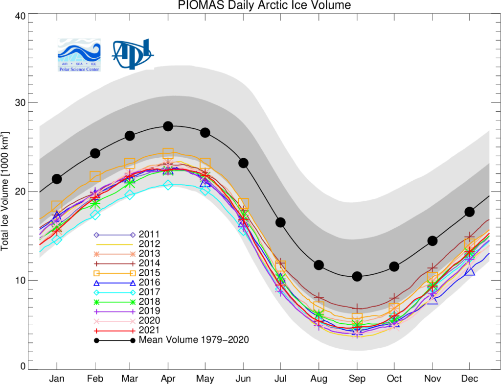
November and December of 2021 saw relative rapid ice growth  for recent years, bringing the mean ice thickness  (above 15 cm thickness) towards the thicker end of  the recent values.
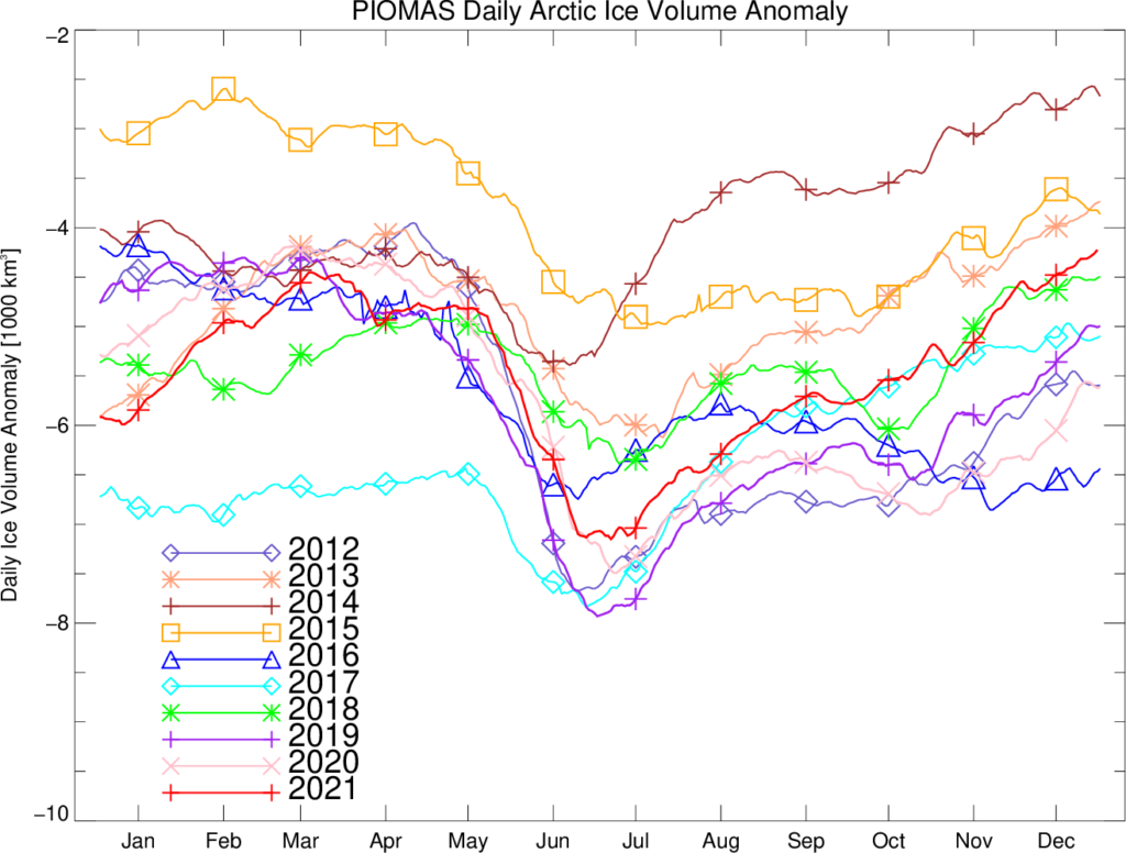
The ice thickness anomaly map for December 2021 relative to 2011-2020 continues to show anomalies divided into positive and a negative halves with areas of positive anomalies increasing since the two prior months and stretching from the Beaufort, over the pole and into the Barents.  Negative anomalies stretching from Fram Strait,  North of Greenland and along the Canadian Archipelago. Areas North of Greenland again feature low ice thickness as in prior years.
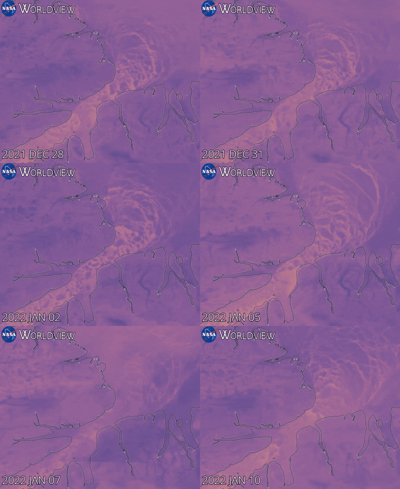
Note that as revealed by this animation from NASA Worldview the sea ice in the Lincoln Sea is currently still breaking up and being exported from the Central Arctic via the Nares Strait:
[Edit – January 25th]

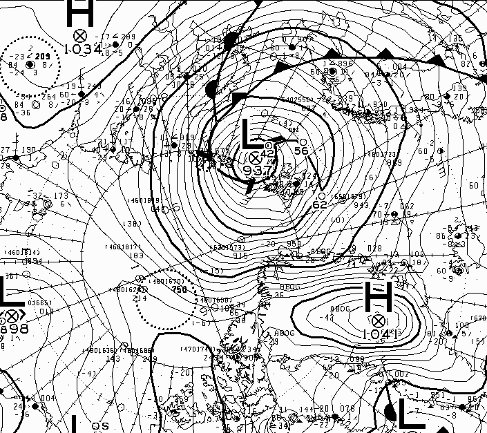
The Atlantic side of the Arctic Ocean has been taking a bit of a battering from what I shall henceforth refer to as the Great Arctic Winter Cyclone of 2022, or GAWC 2022 for short. Unless there’s an even deeper one later in the year of course!

According to the Canadian Meteorological Centre the storm achieved a minimum Mean Sea Level Pressure of 937 hPa at 12 noon UTC yesterday:
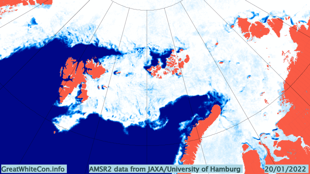
Here are the visible effects of the storm on the sea ice in the area so far, now updated to January 25th:
Watch this space!
The 2021 Maximum Arctic Sea Ice Extent

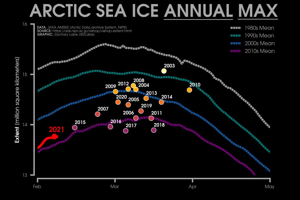
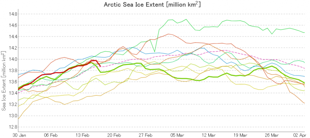
Here’s the latest graph of Arctic sea ice extent from JAXA/ViSHOP, with 2021 and 2015 highlighted:

Extent fell by over 100,000 square kilometres between February 16th and 17th! Can that steep fall continue, as it did for one more day in 2015?

Here too is Zack Labe’s 2021 overview of JAXA maximum extent over the previous couple of decades:

2015’s maximum was very early, on February 15th. Hence the current extremely tentative 2021 maximum is already both higher and later than that. The decadal average extent graphs show the date of the maximum getting later and later, and the 2010’s peaks in the middle of March.

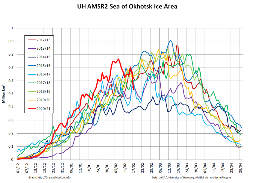
It therefore seems likely that there is more freezing still to come this year. However lets take a look at the high resolution AMSR2 sea ice area graph for the Sea Of Okhotsk:

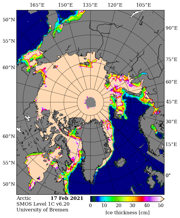
The recent fall in Arctic wide extent has evidently been driven by the recent rapid decline in this peripheral sea, where SMOS reveals more thin ice ripe for further melting:

In conclusion, the high res AMSR2 extent metric shows the tentative 2021 peak below that of 2015!

Continue reading The 2021 Maximum Arctic Sea Ice Extent

New Calving of the Zachariae Isstrom Glacier

The Zachariæ Isstrøm glacier in North East Greenland is in the news at the moment. Here’s a recent article from The Guardian for example, which states that:

A major glacier in Greenland that holds enough water to raise global sea levels by half a metre has begun to crumble into the North Atlantic Ocean, scientists say. The calving of the glacier into chunks of floating ice will set in train a rise in sea levels that will continue for decades to come, the US team warns.

“Even if we have some really cool years ahead, we think the glacier is now unstable,” said Jeremie Mouginot at the University of California, Irvine. “Now this has started, it will continue until it retreats to a ridge about 30km back which could stabilise it and perhaps slow that retreat down.”

Mouginot and his colleagues drew on 40 years of satellite data and aerial surveys to show that the enormous Zachariae Isstrom glacier began to recede three times faster from 2012, with its retreat speeding up by 125 metres per year every year until the most recent measurements in 2015.

The same records revealed that from 2002 to 2014 the area of the glacier’s floating shelf shrank by a massive 95%, according to a report in the journal Science. The glacier has now become detached from a stabilising sill and is losing ice at a rate of 4.5bn tonnes a year.

Eric Rignot, professor of Earth system science at the University of California, Irvine, said that the glacier was “being hit from above and below”, with rising air temperatures driving melting at the top of the glacier, and its underside being eroded away by ocean currents that are warmer now than in the past.

“The glacier is now breaking into bits and pieces and retreating into deeper ground,” he said. The rapid retreat is expected to continue for 20 to 30 more years, until the glacier reaches another natural ledge that slows it down.

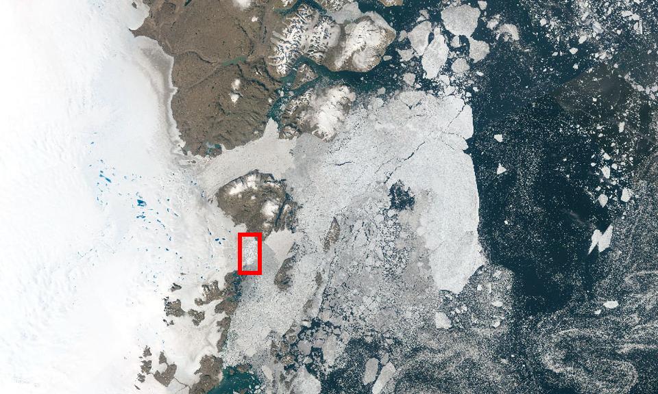
The Guardian article includes a picture of Zachariæ Isstrøm, along with much of the rest of North East Greenland. Here it is again, together with a helpful annotation revealing the location of the calving face of Zachariæ Isstrøm in amongst all the snow and ice:

zach-guardian

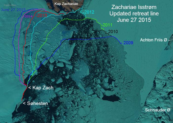
That’s still not really much help when it comes to visualising the “retreat speeding up by 125 metres per year”, so here’s a closer look at Zachariae Isstrom using an image prepared by Espen Olsen for the Arctic Sea Ice Forum, which is based on a Landsat 8 satellite image from September 2014:

Retreat of the calving face of the Zachariae Isstrøm glacier between 2009 and 2015

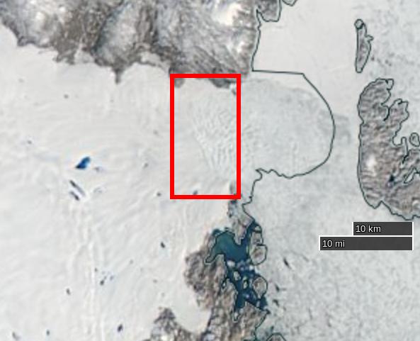
North East Greenland is in the dark at the moment, but if you want to take a closer look at recent changes to Zachariæ Isstrøm for yourself you can do so with the aid of NASA’s EOSDIS Worldview web site, which allows you to scroll through images from both the Aqua and Terra satellites. Here’s one from August 26th 2015:

NASA Worldview “true-color” image of the Zachariae Isstrøm glacier on August 26th 2015, derived from the MODIS sensor on the Aqua satellite

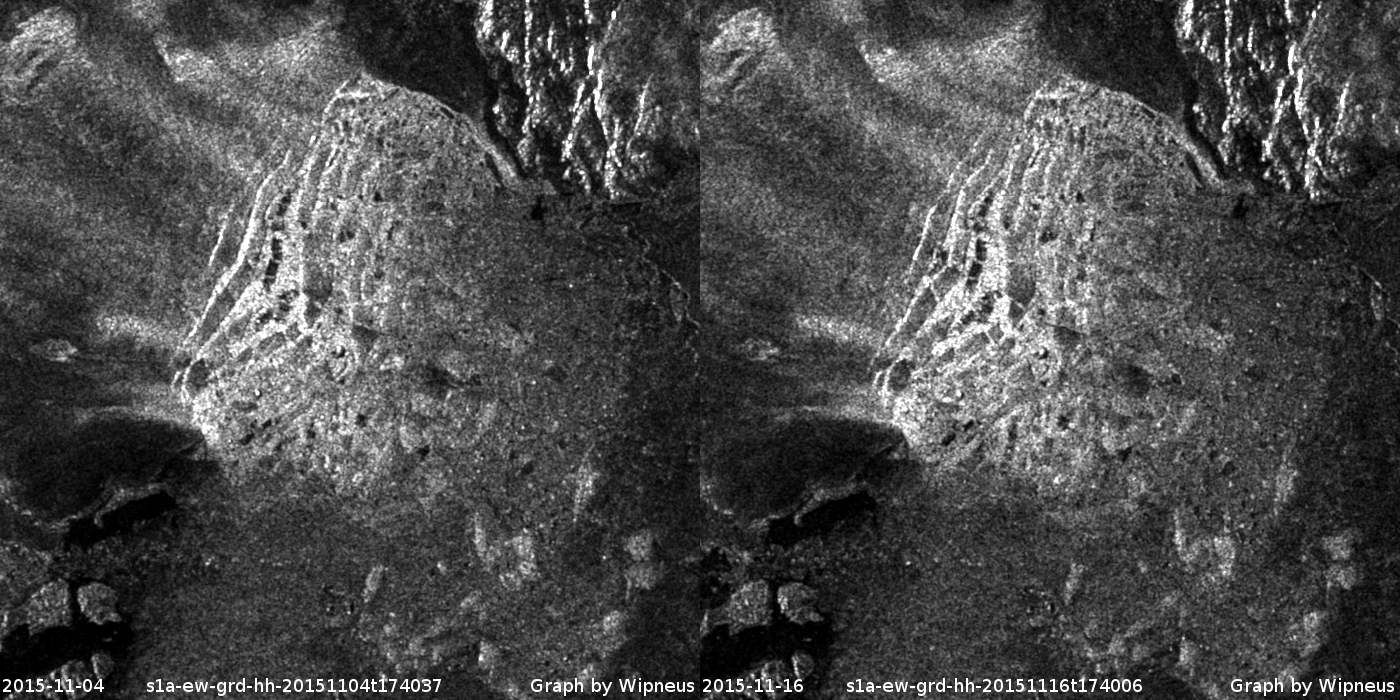
Our headline for today announces that yet another large chunk of ice has just detached itself from Zachariæ Isstrøm. You may wonder how we can be so sure of that when it’s dark in North East Greenland? That’s because yet another satellite can “see” in the dark, using synthetic aperture radar. Here’s an animation prepared earlier today by “Wipneus” using data from the European Space Agency’s Sentinel 1A satellite, once again for the Arctic Sea Ice Forum:

Animated comparison of Sentinel 1A visualisations of the Zachariae Isstrøm calving face on 4th and 16th November 2015

Can you spot “The new iceberg [that] seems to lie on its side”?

The conclusion to all this frantic activity, according to Mouginot, Rignot et al. at least, is that:

The Zachariæ Isstrøm / Nioghalvfjerdsfjorden sector is one of three major marine-based basins in Greenland along with the Jakobshavn Isbræ and Petermann–Humboldt glaciers, each holding a 0.6-m sea-level equivalent. Jakobshavn Isbræ started a rapid retreat (18 km in 2001-2015) following the collapse of its ice shelf and has undergone massive calving events since 2010. The central channel of the Petermann ice shelf lost 250 m of ice in 2002-2010, and the ice front retreated 33 km in 2010-2012. The Nioghalvfjerdsfjorden ice shelf will become vulnerable to break up in the near future if thinning continues. These observations combined suggest that all three major marine-based basins are undergoing significant changes at present. Jakobshavn Isbræ and Zachariæ Isstrøm have already transitioned to tidewater glacier regime, with increased calf-ice production and ice melting by the ocean. The retreat of these marine-based sectors is likely to increase sea-level rise from Greenland for decades to come.

How Many Subs In Santa’s Swimming Pool?

An extract from a  discussion about submarines surfacing at the North Pole, courtesy of Steven Goddard’s “Real Science” blog. One of us must be blind!

Them:

Hey spambot, what is this picture of?

USS Skate (SSN-578) made submarine history on 11 August 1958 when it became the first submarine to surface at the North Pole

Us:

It would seem to be the USS Skate on 11 August 1958 when it became the first submarine to surface at the North Pole. What is this picture of?

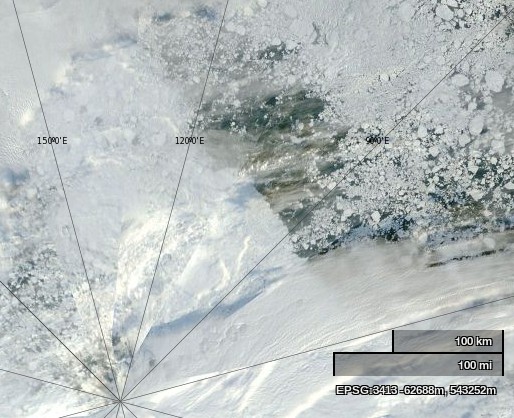
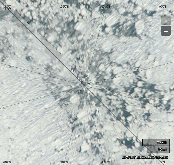
NASA Worldview “true-color” image of the North Pole area on September 2nd 2013

NASA Worldview “true-color” image of the North Pole area on September 2nd 2013, derived from bands 1, 4 and 3 of the MODIS sensor on the Terra satellite

Them:

Frozen ice. What is my prize?

And basically yours is just a snipe hunt. Mine disproves your hysteria.

Us:

No prize I’m afraid. The correct answer is vast areas of open ocean. Plenty of room for every submarine on the planet.

Them:

Sorry, there is no open water. Check your picture again. So you are reneging? Typical.

Us:

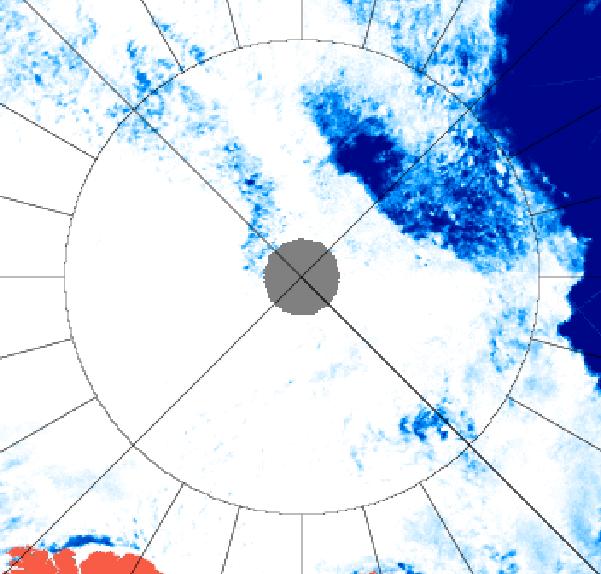
I have checked again, and I still see lots of open water underneath a thin veil of cloud. Perhaps you should arrange a hasty visit to an optician? Luckily microwaves can see through clouds, even if you cannot. Here’s another satellite image of the North Pole area from September 2nd 2013, this time a University of Hamburg visualisation of data from the AMSR2 sensor on board the Japanese SHIZUKU satellite.

AMSR2 image of the North Pole area on September 2nd 2013

AMSR2 image of the North Pole area on September 2nd 2013

The circle is 85 degrees North. How many subs do you suppose will fit into Santa’s secret summer swimming pool?

Them:

You have X-ray vision? I am sorry! I did not realize you were stuper girl! Want to try again? This time with normal vision.

BTW. for the SLOOOOOW learners. 85 North +/= North pole. The North Pole is WITHIN 85 North. But it is NOT 85 North.

The Skate is at 90 North. The NORTH POLE.

You may have x-ray vision, but you still cannot read a map. neither picture shows open water AT the north pole.

How many submarines are on the planet Snowy? better recheck your figures. They are not tinker toys.

Us:

You’re a hard man to please Phil! Feast your eyes on this picture instead then:

NASA Worldview “true-color” image of the North Pole area on August 28th 2013, derived from bands 1, 4 and 3 of the MODIS sensor on the Aqua satellite

NASA Worldview “true-color” image of the North Pole area on August 28th 2013, derived from bands 1, 4 and 3 of the MODIS sensor on the Aqua satellite

Them:

We’ll keep you posted!