In the latest edition of their “Arctic Sea Ice News” the United States’ National Snow and Ice Data Center have announced that:
Arctic sea ice appears to have reached its annual maximum extent on March 24, and is now the lowest maximum in the satellite record, replacing last year’s record low. This year’s maximum extent occurred later than average. A late season surge in ice growth is still possible. NSIDC will post a detailed analysis of the 2015 to 2016 winter sea ice conditions in early April.
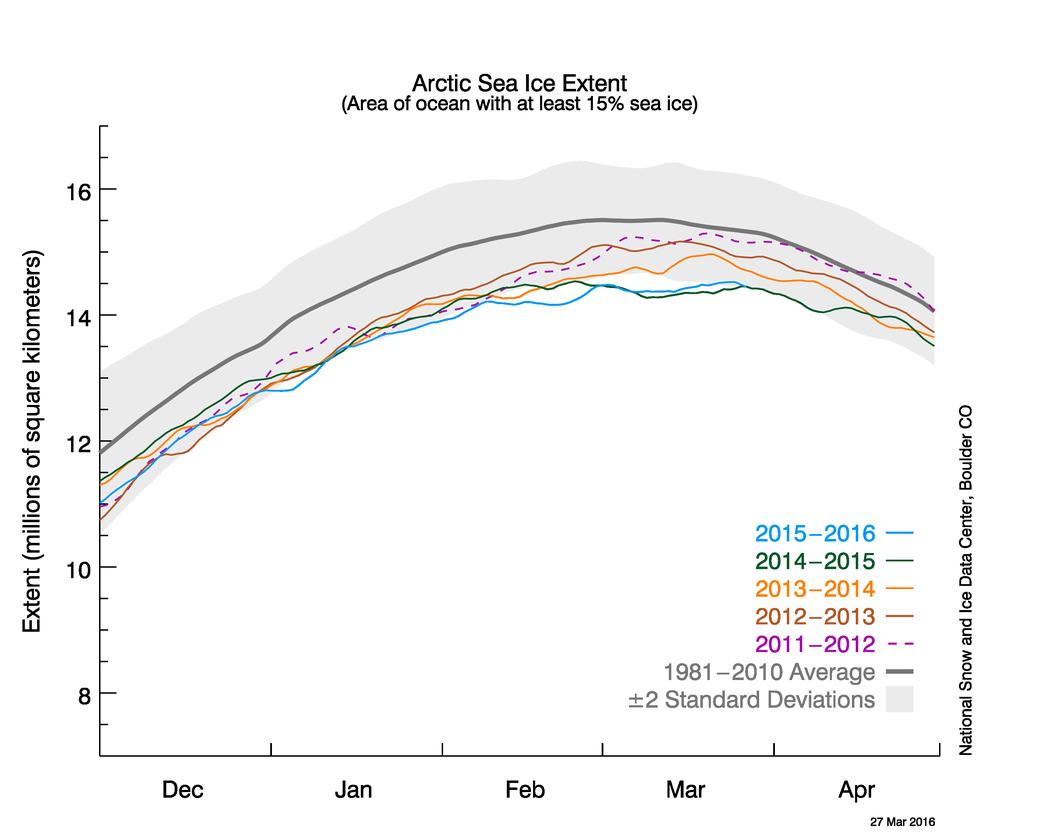
On March 24, 2016, Arctic sea ice likely reached its maximum extent for the year, at 14.52 million square kilometers (5.607 million square miles). This year’s maximum ice extent was the lowest in the satellite record, with below-average ice conditions everywhere except in the Labrador Sea, Baffin Bay, and Hudson Bay. The maximum extent is 1.12 million square kilometers (431,000 square miles) below the 1981 to 2010 average of 15.64 million square kilometers (6.04 million square miles) and 13,000 square kilometers (5,000 square miles) below the previous lowest maximum that occurred last year. This year’s maximum occurred twelve days later than the 1981 to 2010 average date of March 12. The date of the maximum has varied considerably over the years, occurring as early as February 24 in 1996 and as late as April 2 in 2010.
NASA’s Goddard Space Flight Center has also made a similar announcement, which includes this video:
The new record low follows record high temperatures in December, January and February around the globe and in the Arctic. The atmospheric warmth probably contributed to this lowest maximum extent, with air temperatures up to 10 degrees Fahrenheit above average at the edges of the ice pack where sea ice is thin, said Walt Meier, a sea ice scientist at NASA’s Goddard Space Flight Center in Greenbelt, Maryland.
The wind patterns in the Arctic during January and February were also unfavorable to ice growth because they brought warm air from the south and prevented expansion of the ice cover. But ultimately, what will likely play a bigger role in the future trend of Arctic maximum extents is warming ocean waters, Meier said.
“It is likely that we’re going to keep seeing smaller wintertime maximums in the future because in addition to a warmer atmosphere, the ocean has also warmed up. That warmer ocean will not let the ice edge expand as far south as it used to,” Meier said. “Although the maximum reach of the sea ice can vary a lot each year depending on winter weather conditions, we’re seeing a significant downward trend, and that’s ultimately related to the warming atmosphere and oceans.” Since 1979, that trend has led to a loss of 620,000 square miles of winter sea ice cover, an area more than twice the size of Texas.
This year’s record low sea ice maximum extent will not necessarily result in a subsequent record low summertime minimum extent, Meier said. Summer weather conditions have a larger impact than the extent of the winter maximum in the outcome of each year’s melt season; warm temperatures and summer storms make the ice melt fast, while if a summer is cool, the melt slows down.
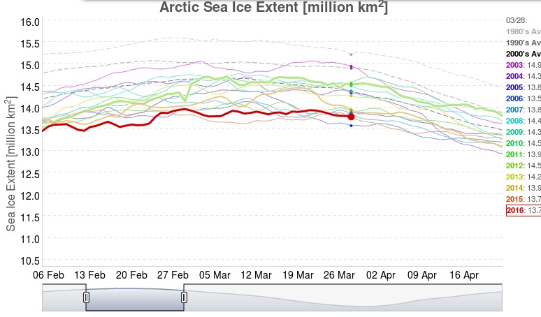
Neither NASA or the NSIDC comment on one of the striking things about this winter’s NSIDC extent chart, which has effectively “plateaued” during March 2016 following an initial peak of 14.48 million square kilometers on March 2nd, which was only recently exceeded. This is also illustrated by the JAXA Arctic sea ice extent metric, for which the 2016 maximum was 13.96 million square kilometers on February 29th:
Now that the start of 2016 Arctic sea ice melting season has been called, albeit slightly hesitantly, by the experts at the NSIDC let’s also take a look at Cryosphere Today Arctic sea ice area:
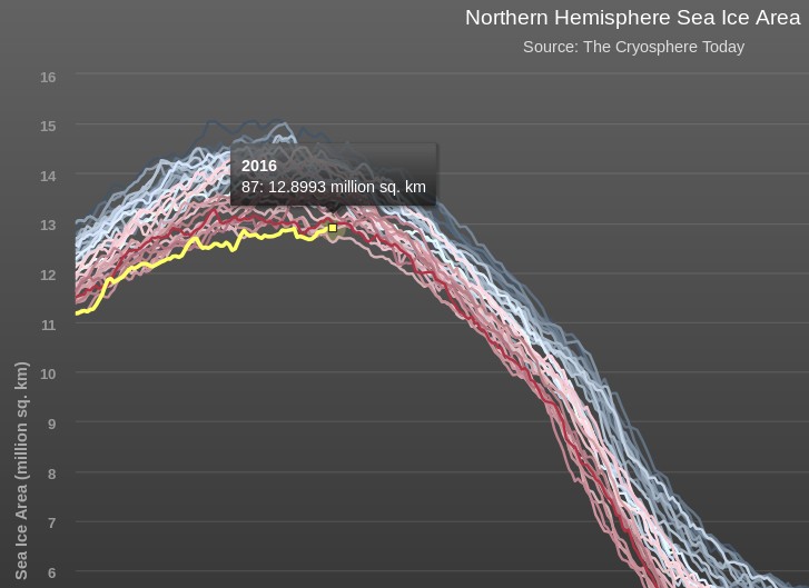
The preliminary peak which we announced on March 16th has also recently been exceeded, but we now feel supremely confident in predicting that the 2016 CT area maximum will be less than 13 million square kilometers for the first time ever in the satellite record.
Thus begins what promises to be a very interesting 2016 Arctic sea ice melting season! As the NSIDC puts it:
There is little correlation between the maximum winter extent and the minimum summer extent—this low maximum does not ensure that this summer will see record low ice conditions. A key factor is the timing of widespread surface melting in the high Arctic. An earlier melt onset is important to the amount of energy absorbed by the ice cover during the summer. If surface melting starts earlier than average, the snow darkens and exposes the ice below earlier, which in turn increases the solar heat input, allowing more ice to melt. With the likelihood that much of the Arctic cover is somewhat thinner due to the warm winter, early surface melting would favor reduced summer ice cover.
Lawrence Martin comments elsewhere that:
I couldn’t resist the temptation to point out the error of his ways concerning MASIE to Ron Clutz, and to my astonishment my comment has now seen the light of day at WUWT! If you don’t believe me please see:
https://archive.is/t6Kej#selection-1445.4-1445.8
Let’s see what happens to my next attempt!
Damn! The poor little #wutz saved me the effort and posted for me at his cesspit. If I didn’t see it with my own eyes I wouldn’t believe it…..
Meanwhile back on the Mann thread, Watt’s has decided he has no problem with dog whistle anti-semitic comments towards Dr Mann. Trust me that may not end well.
I’ve now been honoured with a personal attack on my intellectual capabilities by Anthony himself, including a screenshot from this very thread:
https://archive.is/Vv0eO#selection-1501.1-1501.46
Sadly my witty riposte remains [Snip]ped in its entirety. Here it is:
It seems that the perfect way to “threadbomb” a WUWT discussion concerning a NASA scientist’s views on Arctic sea ice is to mention said NASA scientist’s views on Arctic sea ice!
Anthony wonders “why he keeps trying?”. Because I’m writing a documentary!
We know Watts visits this site, that was made obvious when he posted your edited version of my comment. Today one of his minions made a comment directed towards Reggie… http://bit.ly/1VTc4Rc
You should be ashamed of yourself for the emotional stress you are inflicting on them by posting fact based science that conflicts with what they read in their wingnut alternate reality.
Anthony evidently hasn’t got as far as perusing all our Arctic sea ice resources in detail yet.
Or there again perhaps he has, but he also has a good reason to keep his loyal readers in the dark about the actual facts? No doubt you are right about the “emotional stress” caused by such facts!
After the “plateau” comes the fall. The winds have changed and anomalously high temperatures are returning to the Barents and Kara Seas:
Consequently the sea ice is retreating again north of Svalbard, and JAXA Arctic sea ice extent is once again at the lowest *ever level for the date:
*Since their records began
..is Jim personally looking forward to a “2010s average” I wonder?
(You wouldn’t know where to find a different map of this same data would you? It’s very interesting but a little hard/confusing to read in detail.)
Cheers!
..obviously for soothsayer purposes of course ~;^>
Lastly,
To be exact you are saying that the flatlining (..some might even say “hiatusing”) of Arctic sea ice extent is the phenomena escaping everyones attention perhaps?
To be more exact, I’m wondering what the relevance of the date of the maximum extent is in such circumstances. Particularly when JAXA come up with a much earlier maximum than either NSIDC or CT.
That leads one to wonder what the relevance of the date of the maximum extent is in any circumstances, when “weather” plays such a significant role in these things.
A 2010s average dotted line will ultimately be very interesting!
Which “data” are you referring to AiG? JAXA extent? If so the raw numbers are available from:
https://ads.nipr.ac.jp/vishop/data/graph/plot_extent_n_v2.csv
Plot them any which way you choose!
April 7 temp anomaly at the north pole…
speechless
The DMI’s “Polar Portal” has now also announced the 2016 maximum extent:
Cryosphere Today Arctic sea ice area is once again at the lowest *ever level for the date:
*Since their records began
The NSIDC’s 5 day averaged Arctic sea ice extent has joined the lowest *ever level for the date club:
*Since their records began
Check out Greenland
[For future reference, try wrapping an image in <img src=”my_image_goes_here”> tags]
It looks like the SSMIS instrument on the DMSP F-17 satellite is having a funny five minutes:
Whilst we wait for CT/NSIDC to fix their metrics, here’s JAXA extent:
It has now been officially announced that OSI-SAF are switching from the F-17 satellite to the newer F-18 for their sea ice products:
Willard is sofa king stupid he doesn’t realize he was played like a dime store guitar by Saul and Neven.
#snipgate #JREF
It seems Jim just couldn’t resist joining in the fun. Steven too. Some people have no self control!
Judah Cohen also seems somewhat confused by the SSMIS “glitch”?
Data from:
http://www.star.nesdis.noaa.gov/smcd/emb/snow/HTML/northernhemisphere_multisensor.html
If I was a gambler my money would be on Saul using Marcus to illustrate that WUWT is nothing more than troll central for the astroturf spin machine’s anti climate change crusade.
Did you happen to notice Saul’s comments on the David R. Legates thread this morning? Same question regarding Mosher’s comments on sat thread…
We certainly are living in interesting times!
I’m afraid I have better things to do than read Legates@WUWT Lawrence!
I did notice Neven giving Saul a hard time on the “Satellite Shock News!” thread though, and Willard giving Mosher an even harder time:
Meanwhile Willis and JAXA seem to be contemplating some sort of collaborative sea ice project?