Regular readers of this blog will no doubt have realised that way up here in the Great White Con Ivory Towers we concluded many moons ago that Arctic sea ice is the “canary in the climate coal mine”.
Unlike some others we have already mentioned we were not the beneficiaries of a review copy of Steven E. Koonin’s new book, catchily entitled “Unsettled: What Climate Science Tells Us, What It Doesn’t, and Why It Matters”. Hence I was compelled to acquire my own review copy, and have just purchased the electronic version. I eagerly searched the virtual weighty tome for the term “Arctic sea ice”, and you may well be wondering what I discovered?
Nothing. Nada. Zilch. ничего такого. Nic.

I broadened my thus far vain search by removing the “Arctic” specifier, which revealed:
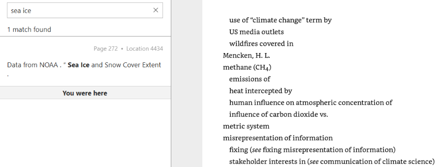
No mention of “sea ice” in the body of the book, merely a reference to the data underlying this graph of northern hemisphere snow cover:
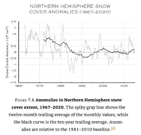
I am forced to an unsettling conclusion. Evidently there are some areas of climate science that Dr. Koonin tells his eager readers nothing whatsoever about. It seems likely that he is also well aware that Arctic sea ice is the canary in the climate coal mine, which is why he has chosen to make no mention of it in his magnum opus.
Here is an informative video which will no doubt not appear in “Unsettled – The Movie”:
Having now had time to read some of Steve Koonin’s “Unsettled Climate Science” at greater length I have discovered that it does contain one reference to Arctic sea ice, albeit using non-standard terminology. On page 40 of the Kindle version of the book I read:
Rising temperatures at the surface and in the ocean are not the only indicators of recent warming. The ice on the Arctic Ocean and in mountain glaciers has been in decline, and growing seasons have been lengthening slightly. Satellite observations show that the lower atmosphere is warming as well.
A paragraph I can broadly agree with, but I am compelled to ask why Dr. Koonin does not quantify the “decline of the ice on the Arctic Ocean” anywhere in the book? There are a wide variety of metrics used to quantify the “amount” of sea ice in the Arctic, but here is one readily available for download from the NASA web site. It is hard to believe that a scientist of Dr. Koonin’s experience, particularly one writing about climate change, has never previously come across a similar graph of Arctic sea ice extent:
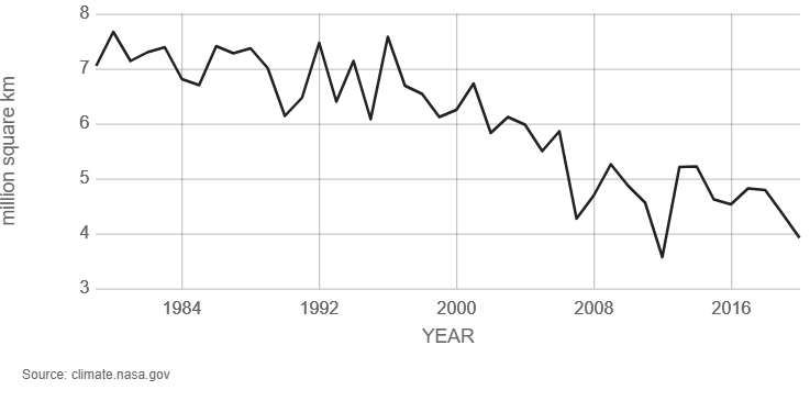
It seems safe to assume that Dr. Koonin has heard of NASA, since the organisation is mentioned several times in his list of references and once in the body of the book. However it seems that the United States’ National Snow and Ice Data Center (NSIDC for short) is not very visible on his personal radar screen, meriting only a single reference which is to snow rather than ice data.
Here is the NSIDC’s version of the NASA graph above, which includes a handy trend line:
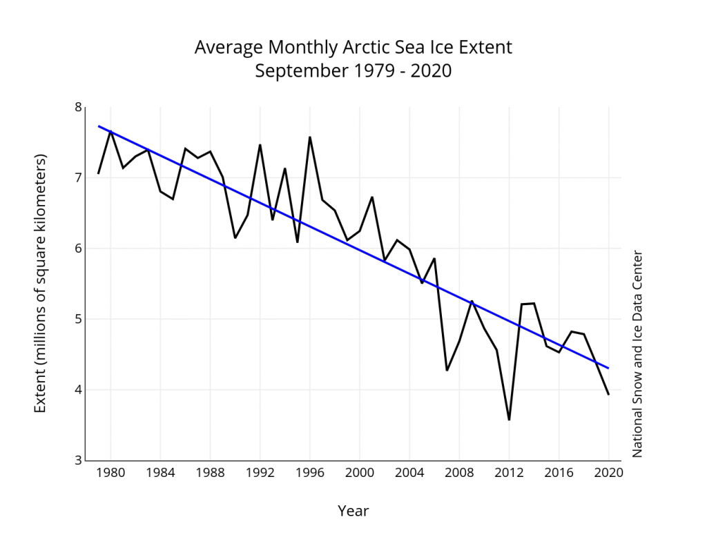
Nearby Steve has penned another paragraph I can broadly agree with. On page 36 he states:
The warming of the past forty years on large scales hasn’t been uniform over the globe. That’s evident in Figure 1.5, reproduced from the US government’s 2017 CSSR (Climate Science Special Report, described earlier). As you can see, the land is warming more rapidly than the ocean surface, and the high latitudes near the poles are warming faster than the lower latitudes near the equator.
Here is the figure 1.5 referred to above:
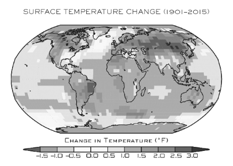
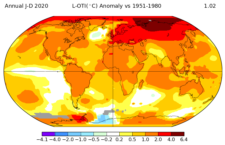
Once again I am compelled to ask some questions. Why not include a map that uses more recent data than 2015? And why not quantify how much faster the “high latitudes near the poles are warming than the lower latitudes near the equator”?
NASA helpfully provide an interface to their data which allows anybody who can click a mouse to produce their own global surface temperature maps. Here is the up to date answer to the first question:
NASA have also produced another informative video, which I suspect will also never make it into “Unsettled – The Movie”:
Another US scientific agency that provides publicly accessible climate data is the National Oceanic and Atmospheric Administration (NOAA for short). The abbreviation is referred to several times in Steve Koonin’s book, but for some reason he never expands the acronym in full. Like NASA they also provide a means to produce your own maps and time series. Albeit with a somewhat more complex user interface, the Web-based Reanalysis Intercomparison Tool (WRIT for short) allows the user to differentiate between different regions of Planet Earth, and hence answer the second question above.
Please compare and contrast the “non polar” temperature time series with the “Arctic” one. Note the change of scale of the X axis, and also the units. Degrees Kelvin rather than degrees Fahrenheit which are seemingly preferred by Dr. Koonin:
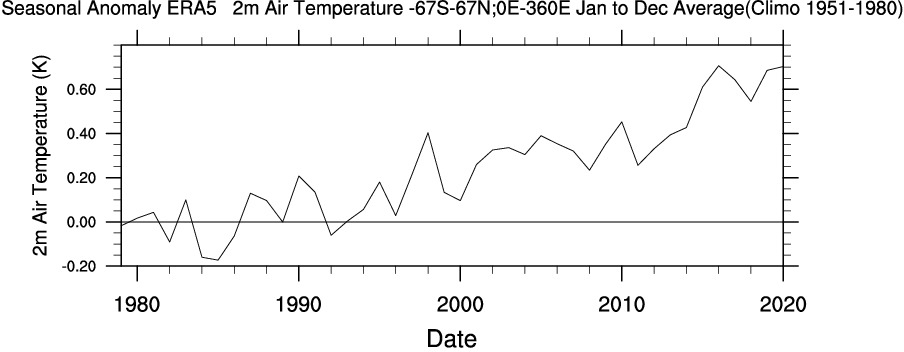
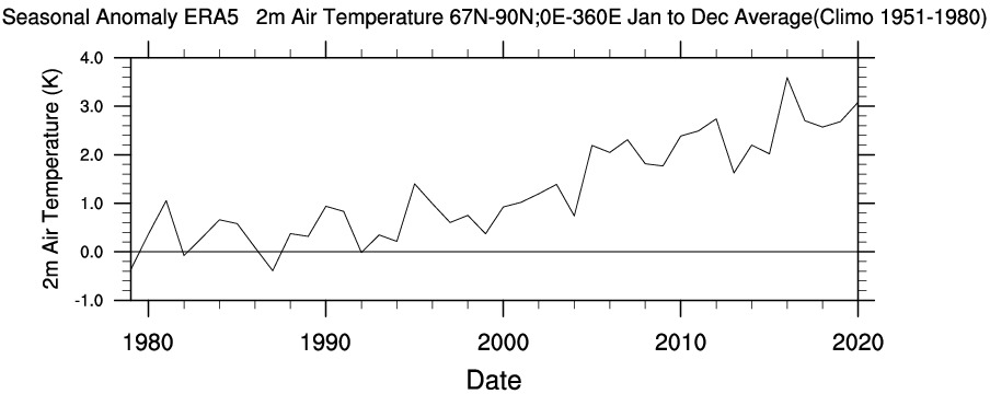
To summarise, you don’t need to wait for Steve Koonin to write another book or for the US government to produce another CSSR. Vast amounts of data and a plethora of visualisation tools are freely available to allow you to do your own research regarding a wide variety of climate metrics. Steve neglects to impart that information to his readers as well.
As has been alluded to above, in the soon to be shipped hardcover edition of his new book Steve Koonin makes much mention of “snow cover” whilst ignoring “sea ice” entirely. There are also a grand total of 48 reference to the perhaps overly esoteric term “albedo“. On page 84 of the Kindle edition of “Unsettled” we are reliably informed that:
Among the most important things that a model has to get right are “feedbacks.”
Despite that the entire electronic volume makes no mention whatsoever of the phrase “ice-albedo feedback” or any synonym thereof. A brief course teaching the topic has recently been developed as part of the outreach activities of the MOSAiC Arctic drift expedition. Perhaps Dr. Koonin would be well advised to read it at his earliest convenience?
The ice-albedo feedback is an example of a positive feedback loop. A feedback loop is a cycle within a system that increases (positive) or decreases (negative) the effects on that system. In the Arctic, melting sea ice exposes more dark ocean (lower albedo), which in turn absorbs more heat and causes more ice to melt…the cycle continues.
Here’s another explanatory video which will also no doubt never make it into “Unsettled – The Movie”:
Watch this space for further revelations about the gigantic Arctic canary in the room!
I’ve added a section to the article above, reviewing Steve Koonin’s treatment of “Global surface temperature change” and his unfortunately absent treatment of “Arctic sea ice decline”:
https://GreatWhiteCon.info/2021/05/steve-koonins-unsettled-arctic-science/#May-08
According to science, the Great Lakes were formed by a glacier, 2000 miles long and 1 mile deep. The glacier ice, formed by compacted snowfall, covered Canada, even “chattering” bedrock in Central Park. This, of course, disappeared long before man stood upright. How can you not say that such regression has been going on for tens of thousands of years, and anything man adds to the mix is incidental?
Hi Roger,
To start with I can simply repeat what the IPCC have to say about Arctic sea ice in their recent SROCC, since that is what Professor Koonin asserts is his “gold standard” for “The Science”.
He could of course have mentioned that science in his book. However he assured me that instead he took the view that “The topic is… somewhat distant from ordinary folks’ perception”, so he didn’t.
If you prefer to discuss “glacier ice” then perhaps this is a better place?
https://GreatWhiteCon.info/2021/05/steven-koonins-unsettled-greenland-ice-sheet-science/
I’ve added a section to the article above, expanding upon Dr. Koonin’s strange reluctance to mention ice-albedo feedback anywhere in his new book:
https://GreatWhiteCon.info/2021/05/steve-koonins-unsettled-arctic-science/#May-09
Please see our new article on the unsettling lack of Arctic science in “Unsettled – The Movie”:
https://GreatWhiteCon.info/2021/05/koonins-unsettled-science-the-movies/
as usual, arctic sea ice extent begins at 1980 , maximum sea ice year since the little ice age . likely much larger than most of the earlier holocene . climate did not begin in 1980
Hi Jeff,
You seem to be suffering from a few Arctic misconceptions? Much like Steve Koonin some might say!
For your information, and Steve Koonin’s, according to the NSIDC web site:
How much further back would you like to go? The NSIDC also make this graph available to avid readers of their “introduction to sea ice” article for example?
Is that one more to your liking?
I agree that we almost never go back long enough when looking at Arctic Ice.
I do not understand for example why climate scientists obsess and foresee disaster with any rise above 1.5 degrees C.
During the Eemian interglacial some 130,000 years ago the rise was more than twice this. Boreal forest stretched up to the North Cape and tropical fauna roamed the Thames valley.
Even with this much warmth, some of the Greenland icecap and nearly all of the Antarctic icecap survived and the CO2 level only rose slightly some time after the warmth had arrived.
Strangely, at the end of the interglacial, CO2 then persisted at this slightly higher level for several thousand years after the warmth ended and the next ice age had kicked in.
Coincidentally we’re discussing “solar irradiance” elsewhere at the moment.
What does Mr. Milankovitch have to say about the Eemian compared to the Holocene? Perhaps the “obsessed” climate scientists you refer to are more concerned about the Paleocene-Eocene Thermal Maximum, when atmospheric “greenhouse gas” levels are alleged to have been higher than today?