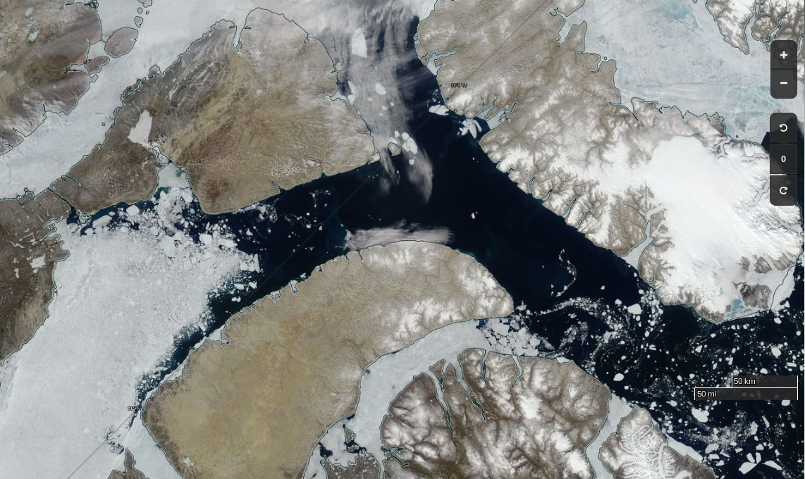
The time has come to start speculating about if, and when, the Northwest Passage will become navigable for the host of small vessels eager to traverse it this summer. The west and east entrances are clearing early this year. Lancaster Sound and Prince Regent inlet already reveal only a few area of white amongst the deep blue open water:
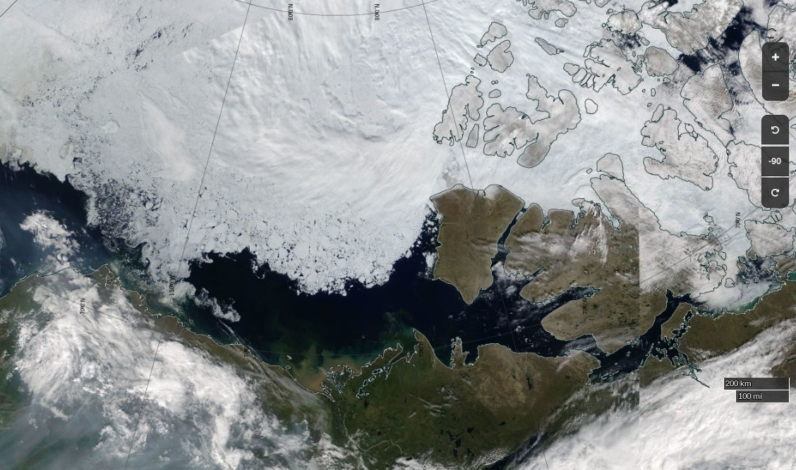
To the west the route is already opening up all the way from the Chukchi Sea to Cambridge Bay:
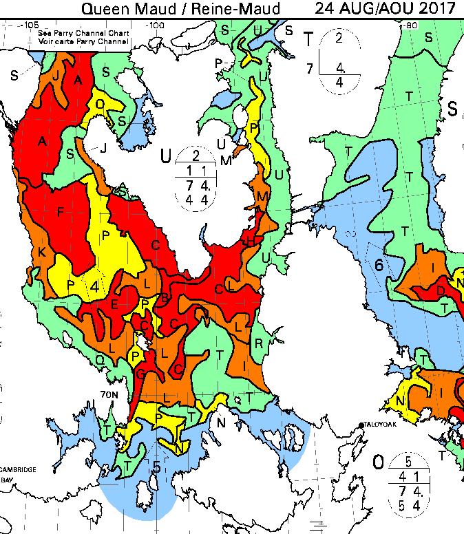
The problems on the southern route seem likely to arise in the central section this year, where far more old ice is present this year than in 2016:
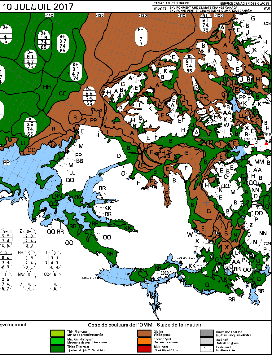
The remaining sea ice in Queen Maud Gulf doesn’t look like it will last long, but the ice in Victoria Strait and Larsen Sound is made of much sterner stuff:
The cruise liner Crystal Serenity is anticipating navigating those waters once again this year, on August 29th. However much smaller craft are already heading for the Northwest Passage. Celebrate and Alkahest are already sailing north along the west coast of Greenland. Meanwhile Yvan Bourgnon is due to depart Nome, Alaska tomorrow, sailing his catamaran single handed in the opposite direction.
According to the United States Coast Guard web site:
The crew of the Coast Guard Cutter Maple, a 225-foot seagoing buoy tender home ported in Sitka, Alaska, departed [July 12th] on a historic voyage through the Northwest Passage.
This summer marks the 60th anniversary of the three Coast Guard cutters and one Canadian ship that convoyed through the Northwest Passage. The crews of the U.S. Coast Guard Cutters Storis, SPAR and Bramble, along with the crew of the Canadian ice breaker HMCS Labrador, charted, recorded water depths and installed aids to navigation for future shipping lanes from May to September of 1957. All four crews became the first deep-draft ships to sail through the Northwest Passage, which are several passageways through the complex archipelago of the Canadian Arctic.
The crew of the cutter Maple will make a brief logistics stop in Nome, Alaska, to embark an ice navigator on its way to support marine science and scientific research near the Arctic Circle. The cutter will serve as a ship of opportunity to conduct scientific research in support of the Scripps Institution of Oceanography.
The Maple crew will deploy three sonographic buoys that are used to record acoustic sounds of marine mammals. A principal investigator with the University of San Diego embarked aboard the cutter will analyze the data retrieved from the buoys.
The Canadian Coast Guard Ship Sir Wilfrid Laurier will rendezvous with the Maple later this month to provide icebreaking services as the Maple makes it way toward Victoria Strait, Canada. The Maple has a reinforced hull that provides it with limited ice breaking capabilities similar to Coast Guard 225-foot cutters operating on the Great Lakes.
There doesn’t seem to be any up to date tracking information for the Maple, but CCGS Sir Wilfrid Laurier has recently arrived off Utqiaġvik (Barrow as was):
Another article by Chris Mooney in the Washington Post includes this image of the eastern entrance to Bellot Strait on August 11th:

According to Chris:
After we’d passed through safely, Claude Lafrance, the ship’s commanding officer, took some time to explain how the strait worked with the help of a navigational chart. In the process, he lent credence to some of the observations made by Larsen over 70 years ago, while also explaining how modern knowledge has made navigating it safe with a proper tidal understanding.
The essence is that depending on when you are in Bellot Strait, the waters can be flowing either westward or eastward at and around high or low tide, respectively. So timing your crossing makes a great deal of difference.
The danger is that if you’re coming from the west (as we were) with the current to your back, you can be moving too fast, and have difficulty steering your vessel as you approach rocks at the end of the strait.
“We always want to go through where it’s more difficult, with the current against you, because it’s a lot easier to control the movement of your ship,” Lafrance said.
Therefore, the two-hour wait was quite intentional: The CCGS Amundsen stayed put until the tide began to shift and the waters to flow back westward, in effect neutralizing the current. Then the ship steamed out easily. “We just passed at the ideal time to go through,” Lafrance said.
Another view of Bellot Strait, this time from Ernest Shackleton yesterday:
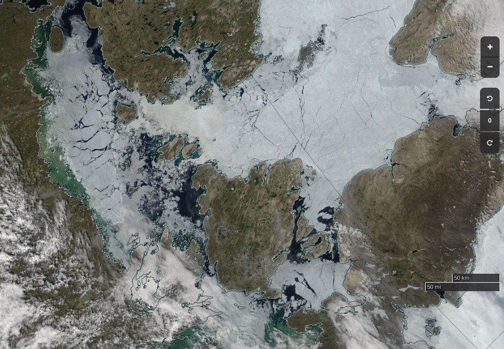
Here’s Sentinel 2A’s view of what he should expect to see in Larsen Sound after emerging at the other end:
From the RRS Ernest Shackleton in Franklin Strait or thereabouts:
From the C3 expedition, also in the Franklin Strait area by the look of things:
Yesterday, we broke through ice that was two metres thick. Thank you to the Canadian Ice Service for ensuring our safe passage! #CanadaC3 pic.twitter.com/2nCgalwPOo
— Canada C3 (@canada_c3) August 22, 2017
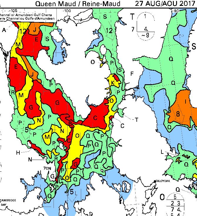
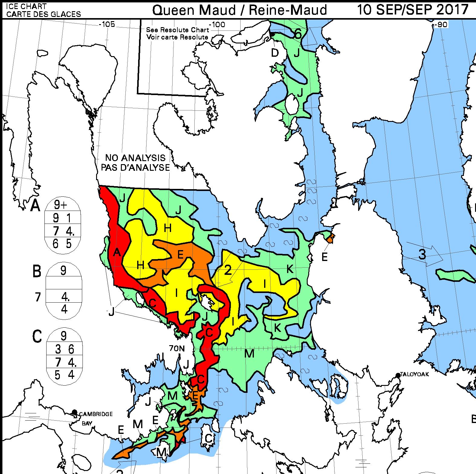
The latest CIS ice chart reveals a circuitous route via McClintock Channel that is ALMOST <= 6/10 concentration. Meanwhile Larsen Sound is still refusing to open up for the imminent arrival of the Crystal Serenity:
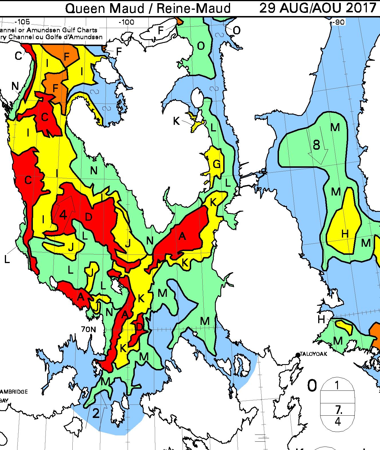
At long last the CIS concentration map reveals a <= 6/10 concentration path along the entire southern route via Bellot Strait:
It is now possible to squeeze through Roald Amundsen’s route through the Northwest Passage without encountering over 6/10 concentration sea ice:
Coincidentally Amundsen’s Maud has started the long journey back to Norway from Cambridge Bay. Thanks to Matthew for the heads up
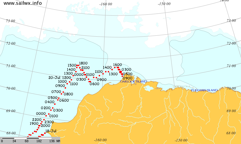
David Scott Cowper sought shelter for Polar Bound in the welcoming arms of Booth Island for a couple of days. Now they’re off again and have taken another close look at Cape Bathurst, but which route will they take now?
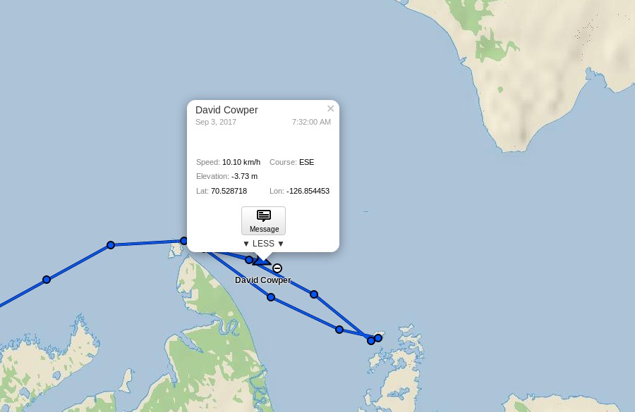
David Scott Cowper has left Cambridge Bay in Polar Bound and is heading east:
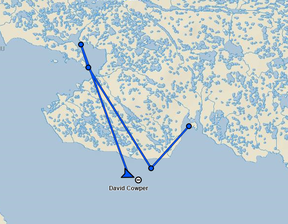
here’s what lies ahead of him:
Watch this space!
The Finnish icebreaker Nordica is currently negotiating the Bering Strait, en route to the Northwest Passage on the “Arctic 100 Expedition”
Ole Torrissen in S/Y Romar is also currently heading north along the west coast of Greenland:
http://northwestpassage.no/en/
Nordica is now negotiating the old ice in Larsen Sound:
Associated Press have a team on board, including a photographer, but no pictures of the area are available yet. Here’s one from July 19th, as Nordica was approaching the Dolphin & Union Strait:
Not much ice to be seen there!
Nordica has negotiated Peel Sound and is entering the Parry Channel:
Nordica has now emerged from Lancaster Sound into Baffin Bay, and uploaded plenty of pictures:
https://apimagesblog.com/blog/2017/7/25/icebreaker-leaves-jagged-beautiful-arctic-icescapes
Great intel.. Thank you Jim
From David “Duke” Snider, ice pilot aboard Nordica:
plus a pretty picture of thick first year ice in Peel Sound:
P.S. Plus the “old ice” in Larsen Sound:
Sir Wilfrid Laurier, now in convoy with Maple, has reached Herschel Island en route to the Canadian Arctic Archipelago:
According to a United States Coast Guard press release:
It looks as though Crystal Cruises are having trouble filling all the berths on the imminent Northwest Passage cruise of Crystal Serenity:
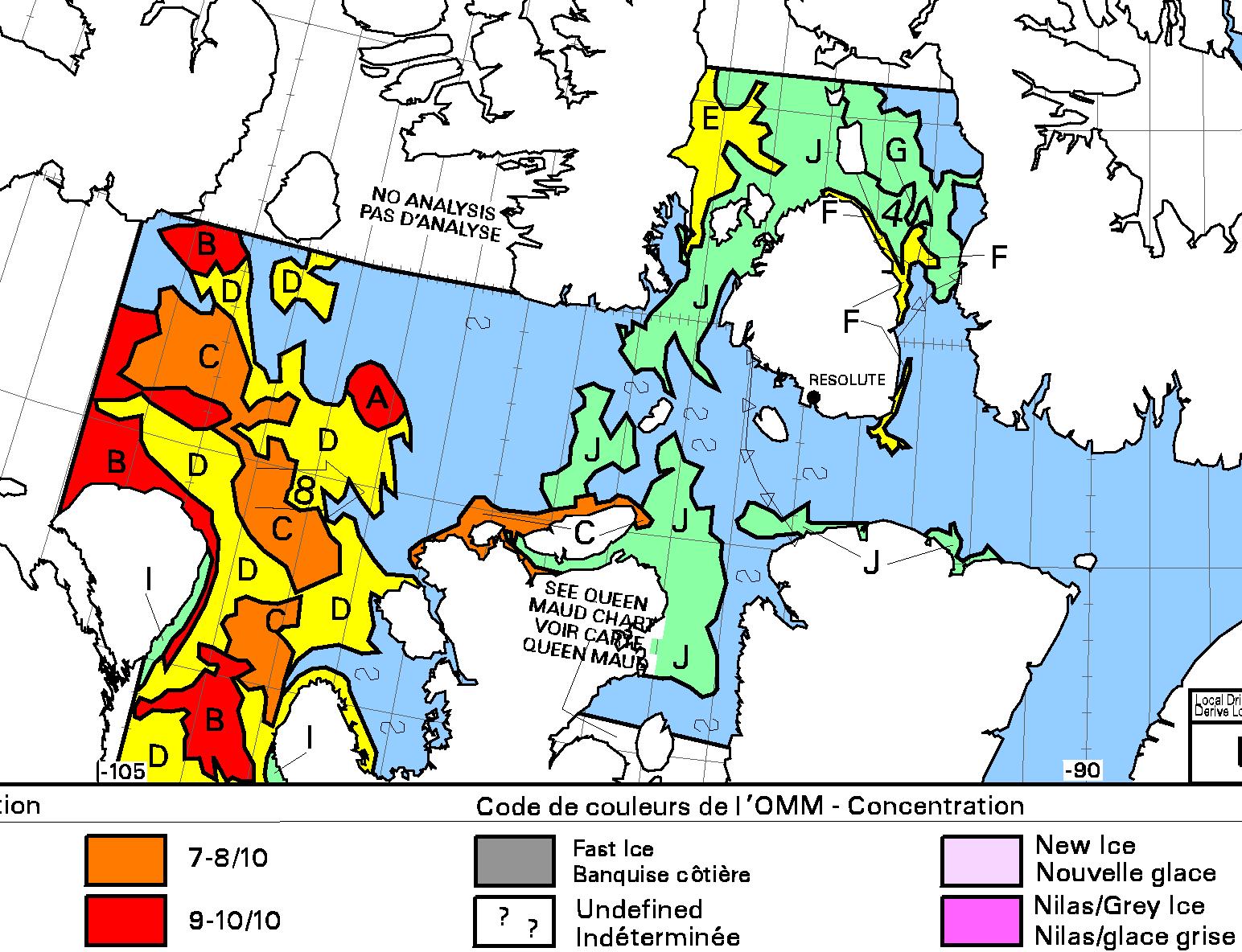
Perhaps prospective passengers have been reading the article above, particularly the bit about all the old ice in Larsen Sound? Here’s the current state of play:
The Washington Post has a couple of reporters embedded on the Canadian icebreaker CCGS Amundsen as she makes her way through the Northwest Passage. Here’s the Amundsen’s current postion:
Chris Mooney reports that:
Here’s how Peel Sound looked from the Amundsen a couple of days ago:
Idly Googling Pen Hadow’s Arctic Mission I stumbled across another Arctic sailing expedition. This one’s called Mission Arctic, and they’ve recently had a good look at the Kane Basin:
According to their blog post:
Now they’re on their way to the Northwest Passage.
Whilst checking on the position of the yachts of the Arctic Mission who should I spot but David Scott Cowper passing Nome in Polar Bound:
En route for yet another voyage through the Northwest Passage.
Tracking for Polar Bound on DeLorme has been turned off but there is a vessel north of King William island all alone that might be Polar Bound. I’m too cheap to pay MarineTraffic.com to see the ships names – is that Polar Bound?
Looks like the next 24-48 hours will be crucial if she can slip past the sea ice based on Canadian sea ice charts.
DeLorme back on for Polar Bound. At harbor 20 km east of Cambridge Bay, so evidently another ship approaching Bellot Strait.
The evidence:
I wonder David is heading next?
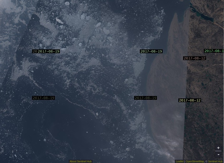
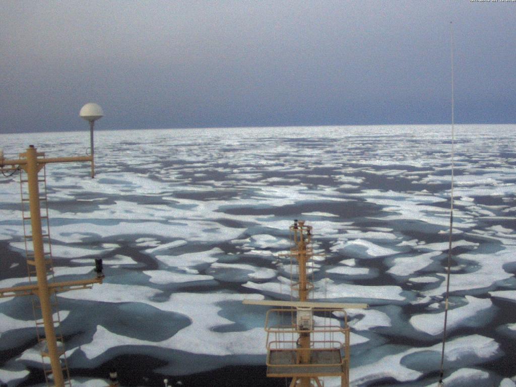
Wildfires in Northern Canada are sending massive quantities of smoke across the Northwest Passage. Here’s the view from above:
and here’s the view from below: