People keep on posing that question just at the moment. Here’s a typical example from the Arctic Sea Ice Blog this morning:
Albeit not ‘officially’ declared as such, the daily Uni-Bremen chart shows Amundsen’s route is cleared and free now.
Here’s an extract from the “Daily Uni-Bremen chart” referred to, with an apparently “ice free” section of the southern route through the Northwest Passage highlighted:
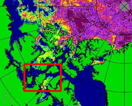
As we’ve been discussing here recently, the automated passive microwave based satellite Arctic sea ice concentration products can miss ice that’s visible to the naked human eye. Here’s some pictures from the Great White Con Northwest Passage page:
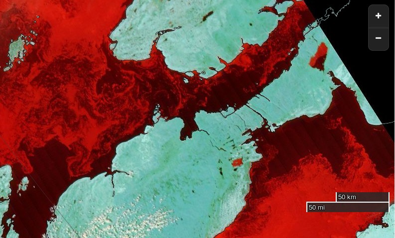
Here’s an extract from the NSIDC’s Multisensor Analyzed Sea Ice Extent (MASIE) product (currently for August 12th 2015):
and here’s an extract from an answer I gave to a similar question on the Arctic Sea Ice Forum earlier this morning:
The Canadian Ice Service still have 4-6/10 ice within a whisker of the coast. Would you fancy your chances in amongst that and a bit of a breeze?
The CIS definition of “navigable” is “a criteria of less than 60% ice cover over all sections of the Northwest Passage”. See:
http://ec.gc.ca/glaces-ice/default.asp?lang=En&n=765F63E4-1
and the inset map at:

The answer to the question posed in the title to this article is therefore currently NO, the Northwest Passage is not open yet, both officially from the CIS and unofficially from any mariner with a sense of self preservation in charge of any vessel that isn’t “ice hardened”. In all the circumstances that answer might change quite quickly though!
The Canadian Ice Service have finally published a close up map of the Parry Channel that doesn’t say “No Analysis”. Here it is:
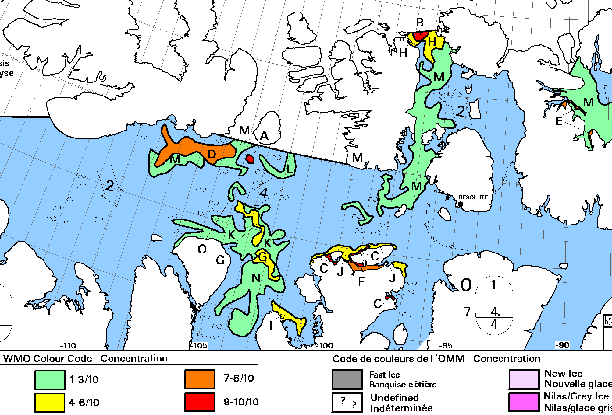
There’s still a (narrow!) green path into McClure Strait, so I reckon we can at long last confidently declare the main Northwest Passage to be OPEN!
i do not have a clue when it might happen jim, but i ould like to take this opportunity to wish all this years intrepid explorers a safe and quick passage .one of the few real challenges left to mariners these days,despite the available technology.
Jimmy Cornell heading east aboard Aventura reports that:
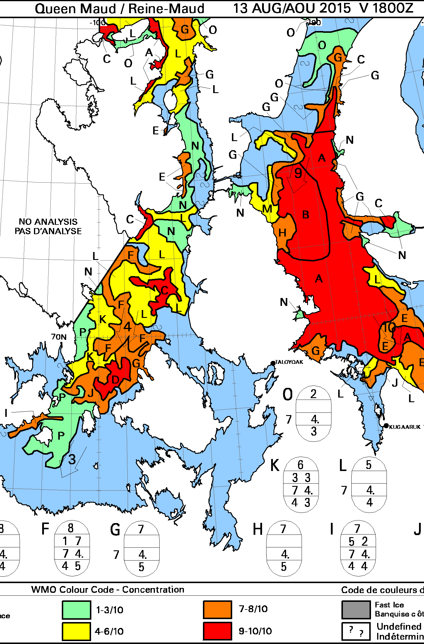
Here’s the new ice concentration map for the Queen Maud Gulf from the Canadian Ice Service:
Here’s the latest from MODIS:
and here’s Aventura’s course through that ice so far today:
I reckon the Northwest Passage is still not “open” using the CIS’s criteria, but the worst now looks to be behind Aventura?
Having been pointed in the direction of the S/V Necton’s own tracking map it’s now clear that they made it through to the Eastern end of Bellot Strait early yesterday morning. They’re currently speeding into Lancaster Sound:
Aventura emerged from the Bellot Strait early today:
Meanwhile Salty Kisses has left Resolute and is currently entering Peel Sound:
Beware … seen on the blog of Douglas Pohl …
2015 Northwest Passage
======================
Vessel Name – Route(s)
======================
M/V ANDROS – East 7 and West 1 – NW Passage Round Trip (Demonstration Project Only)
Quite so Charlie.
After my first (obviously over hasty!) mention of the Andros I noticed hints to that effect on Doug’s blog. Obviously he also has the wherewithal to simulate the supposedly live tracking data.
great effort by both boats jim !
The latest blog post from Aventura documents the passage through Bellot Strait:
Apparently:
just looking at this picture again jim. that piece of ice must surely be about 8 metres thick judging by the amount proud of the water .
will this be true sea ice,or break off from a glacier ? although it looks too “clean” for glacier break off to my inexperienced eyes.
The CIS “state of development” maps do show “bergy bits” off the eastern end of Bellot Strait. However it could also be the remains of a pressure ridge and thus “true sea ice”.
This morning comes news that S/V Selma made it through Bellot Strait travelling west yesterday morning, and is now well on the way to Gjoa Havn:
A picture of the Fort Ross visitor’s book taken by the team aboard Selma suggests that S/V Philos also made it through Bellot Strait heading east on August 13th:
Meanwhile S/V Necton has made it to Dundas Harbour, whilst Salty Kisses reports via Twitter that:
having now made it as far as the western entrance to Bellot Strait:
with S/V Bagheera and S/V Snow Dragon II in close attendance.
Here’s the ice that’s holding them up:
M/V Andros is attempting a voyage through the Northwest Passage in both directions in a single season.
Heading east she has successfully made it through the (extremely unusual!) route via Fury and Hecla Strait and Foxe Basin:
I’m eagerly awaiting the August 29th release of the Canadian Ice Service sea ice concentration maps. Here’s why:
They may reveal the possibility of being able to thread a way through the main Northwest Passage without encountering more than 3/10 sea ice concentration.
Nope. According to the CIS there’s still an area of 9/10 concentration across the Parry Channel:
There may possibly be a way around the north of Byam Martin Island, but the CIS resolutely state “No analysis” in that area. I guess that wouldn’t really count as the Parry Channel either.
Last but not least a slightly cloudy MODIS image is now available:
Given the available evidence the passage isn’t “open” just yet IMHO. Others may of course disagree!
it cannot be far away from being officially open now jim . i am sure i could manage it fairly easily on a jet ski 🙂
Concentration is down to 7-8/10 on the latest CIS chart:
I reckon we can at long last confidently declare the main Northwest Passage to be OPEN!
See above.