Tag Archives: Nares Strait

Facts About the Arctic in May 2017

Before we got on to the more usual Arctic metrics let’s bear in mind that the beginning of May is the time when the ice on the mighty Mackenzie River begins to break up, ultimately sending a surge of (comparatively!) warm water rushing into the Beaufort Sea. The patches of open water visible in the Beaufort Sea off the Mackenzie Delta in early April refroze, but have recently opened up once again:
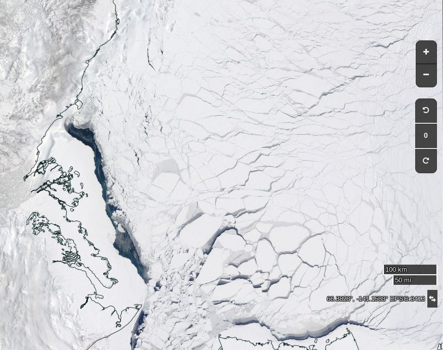
NASA Worldview “true-color” image of the Beaufort Sea on May 2nd 2017, derived from the MODIS sensor on the Terra satellite

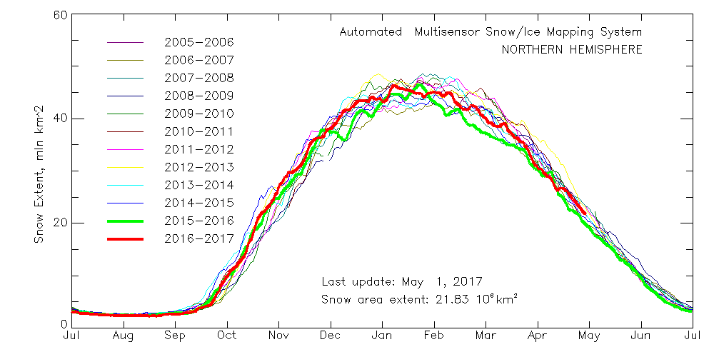
Meanwhile Northern Hemisphere snow cover is falling fast, albeit still above last year’s levels:

multisensor_4km_nh_snow_extent_20170502

Here’s the current view of the Liard River in northern Canada, with the Mackenzie River running bottom to top on the right hand side:
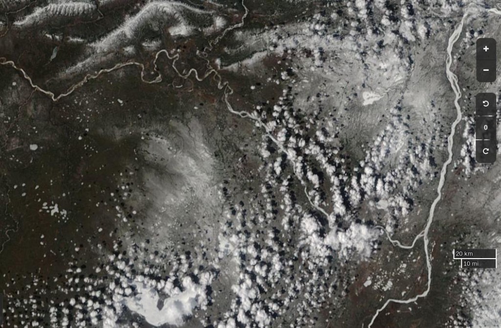
NASA Worldview “true-color” image of the Liard and Mackenzie Rivers on May 2nd 2017, derived from the MODIS sensor on the Terra satellite

The break-up of the Liard leads the Mackenzie, and taking a look at last year’s view of the same area it’s apparent that this year there’s somewhat more snow on the ground, and that this years Mackenzie break-up will therefore be a few days later than last year:
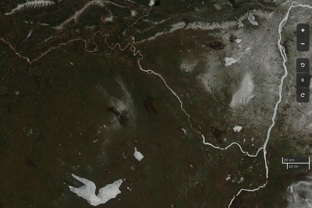
NASA Worldview “true-color” image of the Liard and Mackenzie Rivers on May 2nd 2016, derived from the MODIS sensor on the Aqua satellite

Whilst early melt in the Beaufort Sea is currently behind last year, the reverse is most certainly the case next door in the Chukchi Sea. The skies are rather cloudy there at the moment, but using the Suomi NPP day/night band to peer through the gloom reveals this:
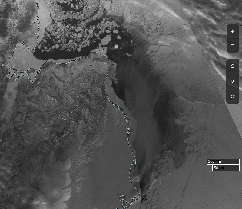
NASA Worldview “day/night band” image of the Chukchi Sea on May 2nd 2017, derived from the VIIRS sensor on the Suomi satellite

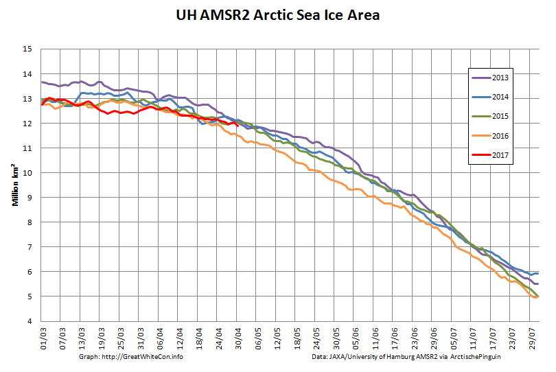
Whilst sea coverage on the Pacific periphery has continued to fall, extent on the Atlantic side has not been following suit. Hence overall Arctic sea ice area is no longer lowest in the satellite record:

UH-Arctic-Area-2017-04-30

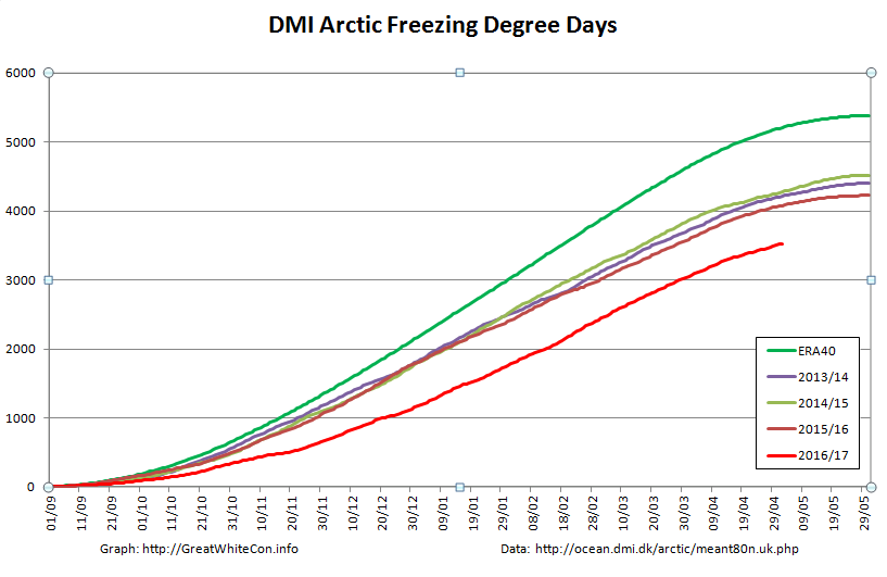
Finally, until the new PIOMAS numbers are released at least, here’s how DMI freezing degree days look at the moment:

DMI-FDD-20170502


[Edit – May 4th]

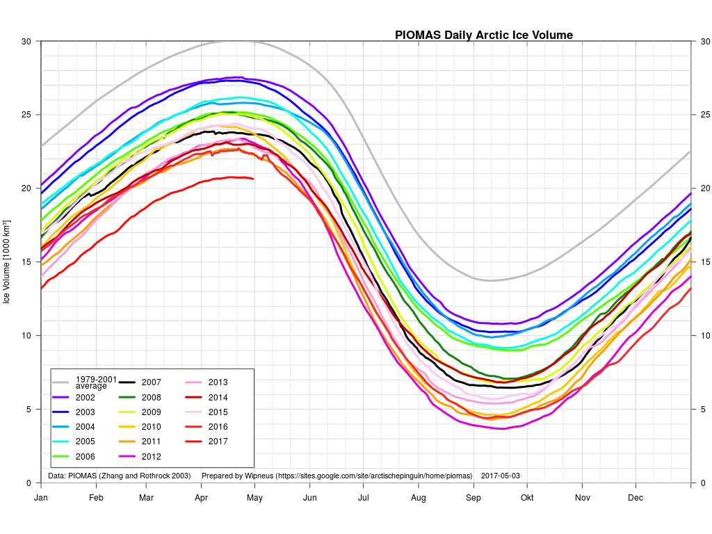
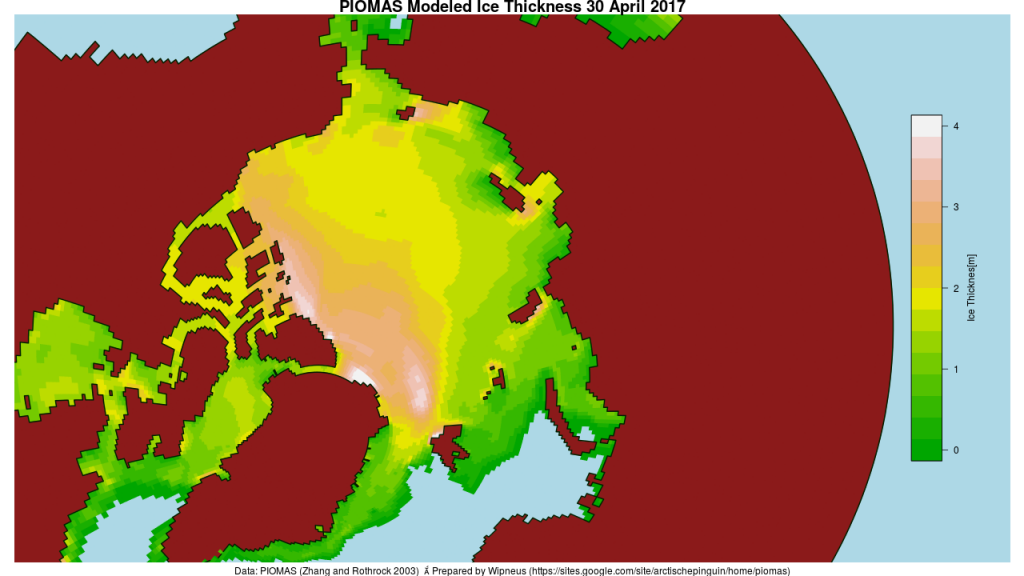
The April PIOMAS numbers have been published: Arctic sea ice volume is yet again by far the lowest on record:

PIOMAS-Volume-20170430

PIOMAS-thk-20170430


[Edit – May 5th]

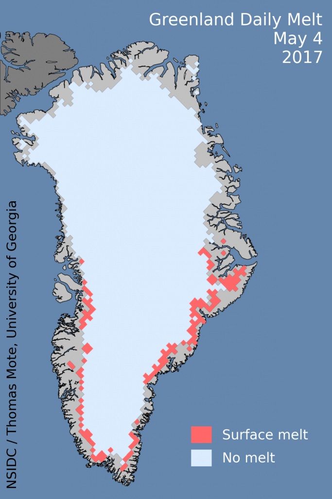
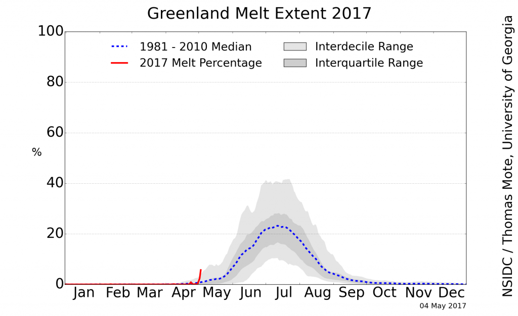
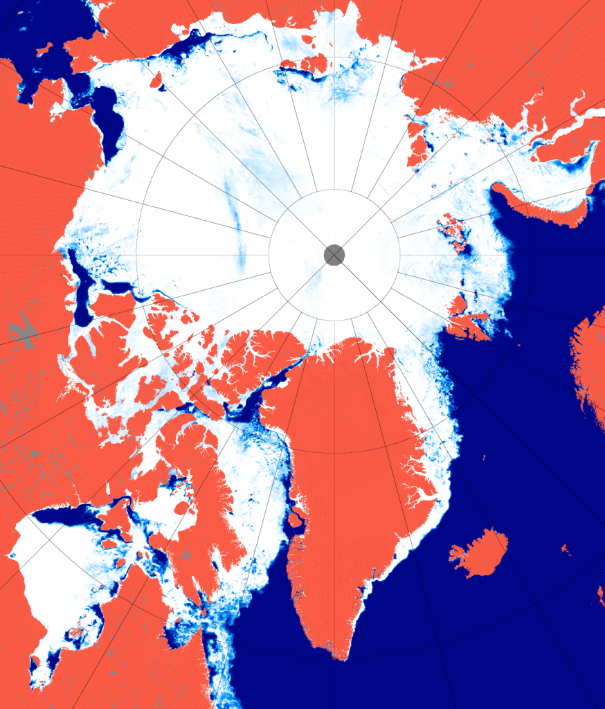
Greenland ice sheet surface melt has started early this year:

greenland_melt_map_20170504

greenland_melt_plot_20170504


[Edit – May 12th]

The ice break-up of the Mackenzie River is now visible as increased flow at the junction with Arctic Red River just south of the delta:
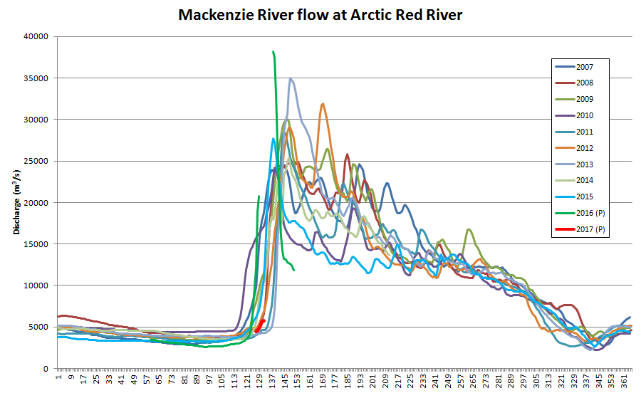
Mackenzie River flow at Arctic Red River up to May 12th 2017

Meanwhile the sea ice in the Lincoln Sea north the Nares Strait is coming apart at the seams:
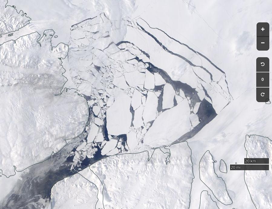
NASA Worldview “true-color” image of the Lincoln Sea on May 12th 2017, derived from the MODIS sensor on the Terra satellite


[Edit – May 17th]

May seems to be shaping up as month of two halves, both spatially and temporally. Here’s an overview of the current state of play:

Arc_20170516_res3.125

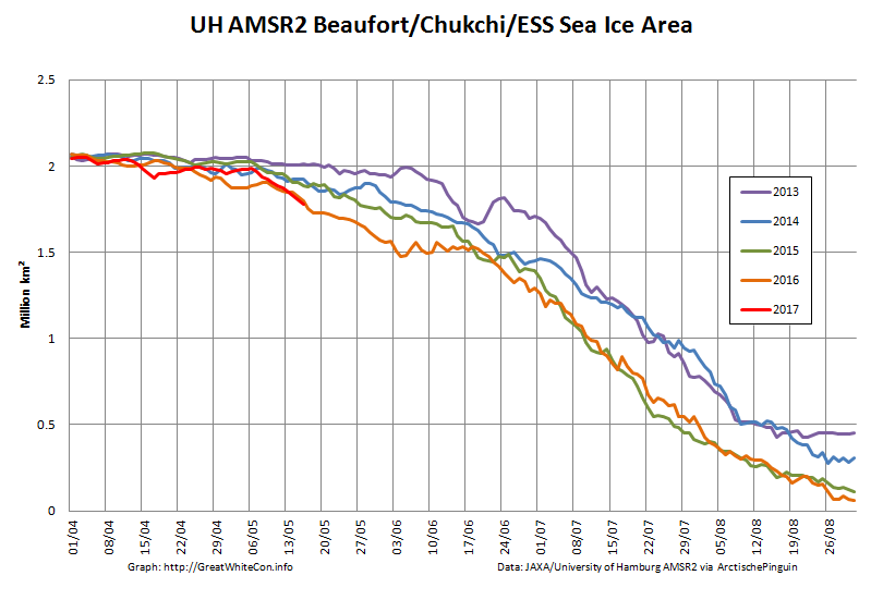
On the Pacific side of the Arctic sea ice area has been declining rapidly courtesy of the expanding areas of open water visible in the Beaufort, Chukchi and East Siberian Seas. It’s currently tracking below other recent years:

UH-Pacific-Extent-2017-05-16

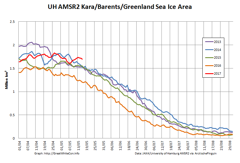
However over on the Atlantic side area has been flatlining, and is currently above other recent years:

UH-Atlantic-Extent-2017-05-16

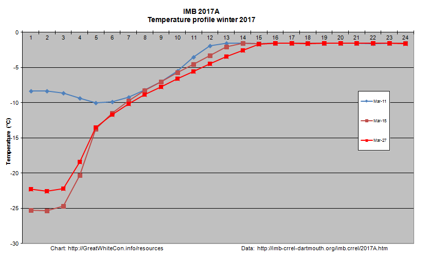
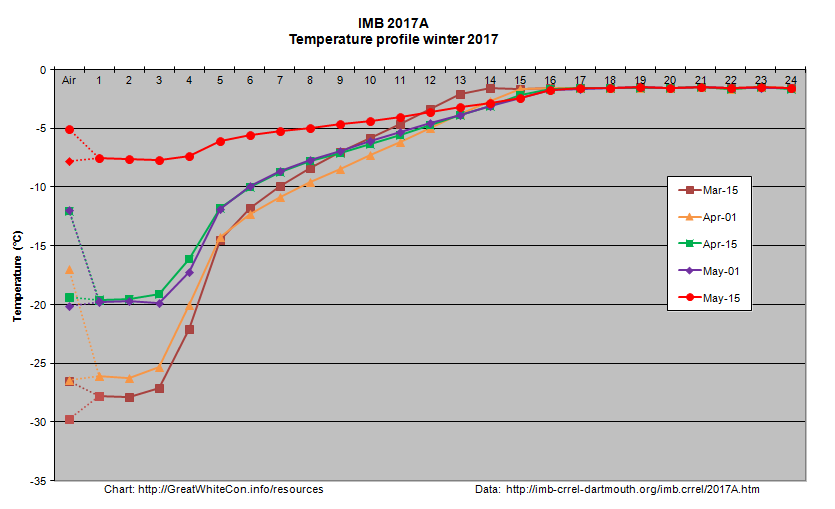
Ice mass balance buoy 2017A is now located near the boundary between the Beaufort and Chukchi Seas and as the melting season in that vicinity rapidly approaches it reveals that thermodynamic thickening has thus far achieved a mere 119 cm:2017A-2017-05-15
Arctic wide sea ice area has recently started to decline at an increasing rate:

UH-Arctic-Area-2017-05-16

During the second half of the month it will be interesting to see whether the forecast high temperatures produce significant melt ponding. If so it’s conceivable that 2017 area could drop below 2016 again by the beginning of June. There already signs of surface melt at places as far apart as Franklin Bay, Chaunskaya Bay and even the Great Bear Lake!

Watch this space!

References

Muhammad, P., Duguay, C., and Kang, K.-K.: Monitoring ice break-up on the Mackenzie River using MODIS data, The Cryosphere, 10, 569-584, doi:10.5194/tc-10-569-2016, 2016.

Rood S. B., Kaluthota S., Philipsen L. J., Rood N. J., and Zanewich K. P. (2017) Increasing discharge from the Mackenzie River system to the Arctic Ocean, Hydrol. Process., 31, 150–160. doi: 10.1002/hyp.10986.

Kwok, R., L. Toudal Pedersen, P. Gudmandsen, and S. S. Pang (2010), Large sea ice outflow into the Nares Strait in 2007, Geophys. Res. Lett., 37, L03502, doi:10.1029/2009GL041872.
Facts About the Arctic in April 2017

Particularly in view of all the balderdash concerning “climate science” being spouted in Washington DC on Wednesday lets first of all run through some Arctic sea ice facts from April 1st 2017 or thereabouts:

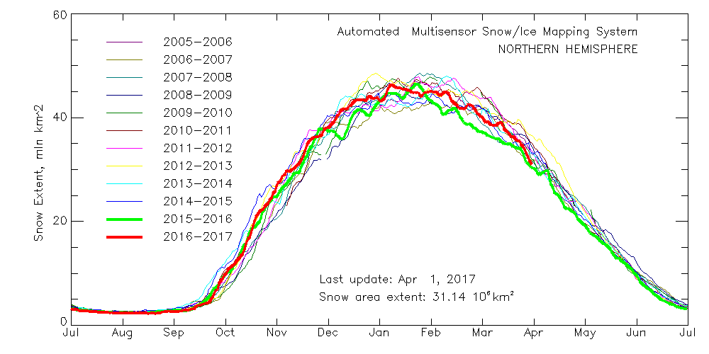
Northern Hemisphere Snow Extent:

multisensor_4km_nh_snow_extent_20170401

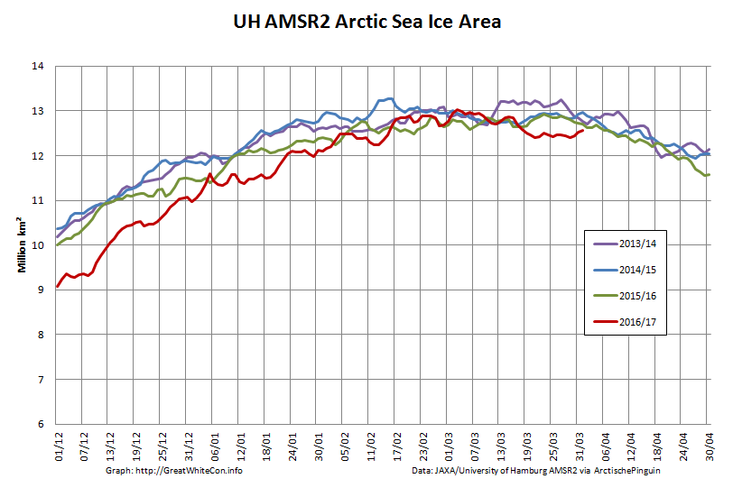
Arctic Sea Ice Area:

UH-Arctic-Area-2017-04-01

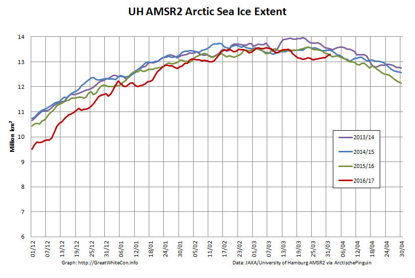
Arctic Sea Ice Extent:

UH-Arctic-Extent-2017-04-01

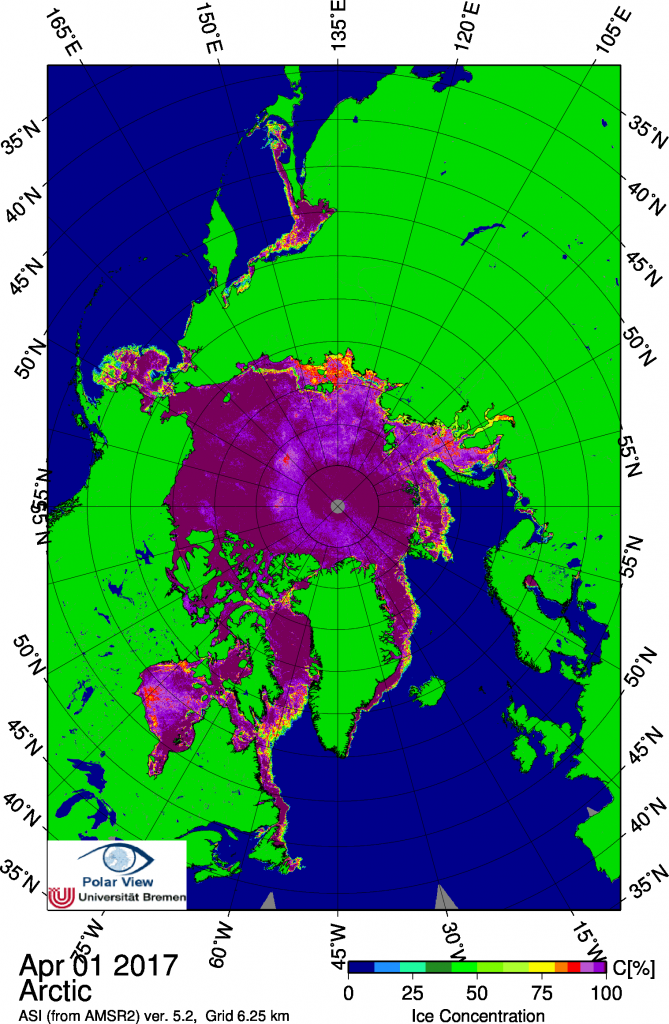
Arctic Sea Ice Concentration:

Bremen_AMSR2_20170401

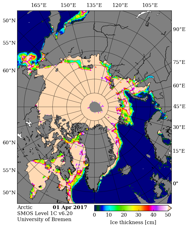
Thin ice map from the University of Bremen SMOS:

SMOS-20170401

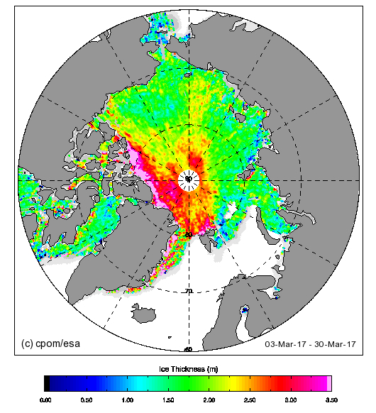
Thick ice map from CPOM CryoSat-2

Cryosat_28_20170330

Beaufort Sea ice thickness growth graph:

2017A-2017-03-27

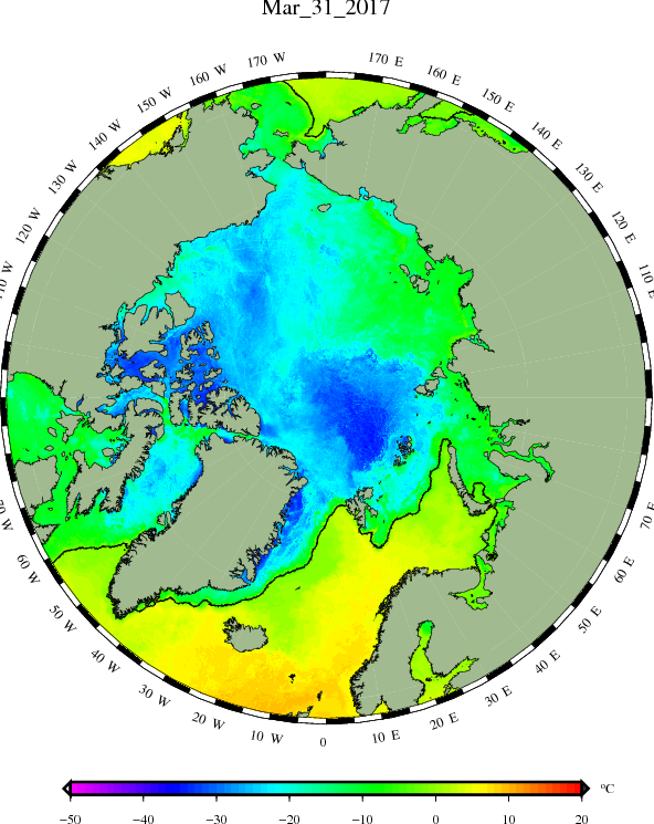
DMI sea ice temperature map:

DMI-icetemp-20170330

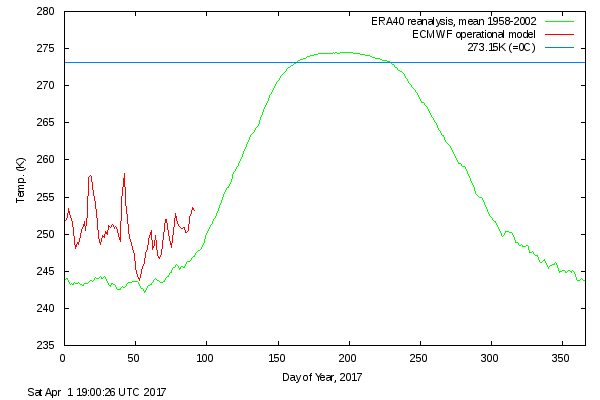
DMI atmospheric temperature graph:

DMI-meanT_20170401

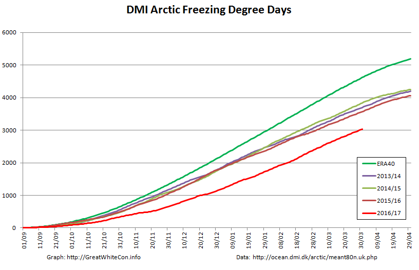
DMI Arctic Freezing Degree Days:

DMI-FDD-20170401

PIOMAS volume for March will follow in a few days, but it’s extremely unlikely to be anything other than “lowest for the date”.

What preliminary conclusions can we draw from this plethora of pretty pictures? First of all the Arctic hasn’t suddenly gone into “deep freeze” mode. Temperatures above 80 degrees north are rising again and are well above the climatology. Freezing degree days are still the lowest on record by a wide margin. Northern hemisphere snow cover is falling fast and is currently just above last year.

In contrast to last year, and thanks to lots of cyclones and very little in the way of anticyclones, there’s plenty of sub half meter sea ice in the Laptev and East Siberian Seas and hardly any in the Beaufort Sea. There’s also plenty of thin ice to be seen on both the Atlantic and Pacific peripheries.

The usual southerly arch hasn’t formed in the Nares Strait between Greenland and Ellesmere Island, and as SMOS shows the sea ice in the strait is consequently very thin. That leads one to wonder when the northern arch in the Lincoln Sea might give way.

It’s not immediately apparent from the still images above, but there’s been relatively large amounts of “old ice” exported from the Central Arctic on the Atlantic side, hence the recent increase in overall extent which is now second lowest for the date (since satellite records began). Area has been creeping up as well over recent days, but is still lowest for the date, as it has been for most of the last year. Sea ice “compactness” has decreased somewhat and given all the thin ice around the edges extent will soon start dropping once again.

All in all, the Arctic sea ice prognosis is not good. Are you watching Lamar Smith? (Pun intended!)


[Edit – April 4th]

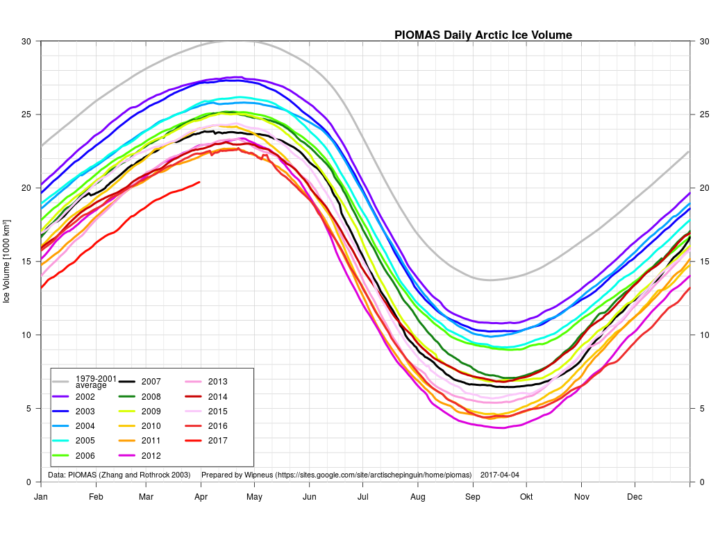
The March PIOMAS update is out! As suspected, Arctic sea ice volume is still by far the lowest on record:

PIOMAS-Volume-20170331

Volume on March 31st 2017 was 20.398 thousand cubic kilometers. The previous lowest volume for the date was 22.129 thousand km³ in 2011.

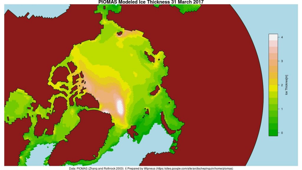
Here too is the PIOMAS modelled Arctic sea ice thickness map:

PIOMAS daily gridded thickness for March 31st 2017


[Edit – April 12th]

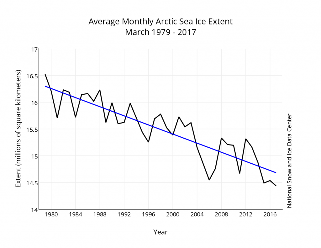
The latest edition of the NSIDC’s Arctic Sea Ice News confirms that their monthly extent metric for March 2017 was the lowest in the satellite record for the month:

monthly_ice_03_NH_v2.1

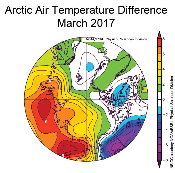
As well as highlighting the anomalously warm temperatures across much of the Arctic:

Mar_925t_anom

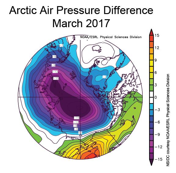
the NSIDC article includes this telling pressure anomaly map:

Mar_925_slp_anom

There’s also mention of a new paper:

New work by an international team led by Igor Polyakov of the University of Alaska Fairbanks provides strong evidence that Atlantic layer heat is now playing a prominent role in reducing winter ice formation in the Eurasian Basin, which is manifested as more summer ice loss. According to their analysis, the ice loss due to the influence of Atlantic layer heat is comparable in magnitude to the top down forcing by the atmosphere.