USS Skate (SSN-578) made submarine history on 11 August 1958 when it became the first submarine to surface at the North Pole
Us:
It would seem to be the USS Skate on 11 August 1958 when it became the first submarine to surface at the North Pole. What is this picture of?
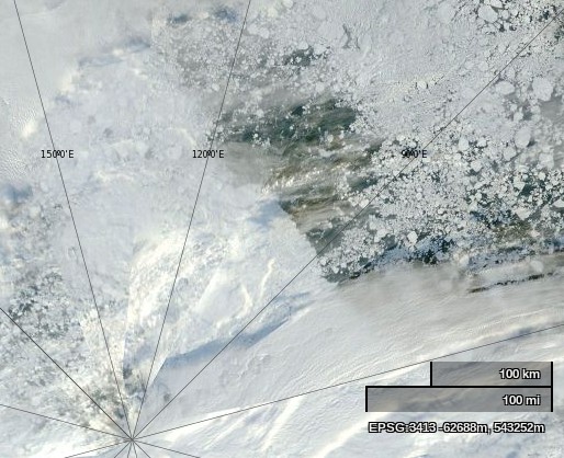
NASA Worldview “true-color” image of the North Pole area on September 2nd 2013, derived from bands 1, 4 and 3 of the MODIS sensor on the Terra satellite
Them:
Frozen ice. What is my prize?
And basically yours is just a snipe hunt. Mine disproves your hysteria.
Us:
No prize I’m afraid. The correct answer is vast areas of open ocean. Plenty of room for every submarine on the planet.
Them:
Sorry, there is no open water. Check your picture again. So you are reneging? Typical.
Us:
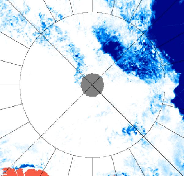
I have checked again, and I still see lots of open water underneath a thin veil of cloud. Perhaps you should arrange a hasty visit to an optician? Luckily microwaves can see through clouds, even if you cannot. Here’s another satellite image of the North Pole area from September 2nd 2013, this time a University of Hamburg visualisation of data from the AMSR2 sensor on board the Japanese SHIZUKU satellite.
AMSR2 image of the North Pole area on September 2nd 2013
Whatever David Rose may say in the Mail on Sunday, satellite images from high above the Arctic make it abundantly clear that there is in fact no “unbroken ice sheet [that] already stretches from the Canadian islands to Russia’s northern shores.”
Should further confirmation of that fact be needed, here’s our latest video analysis of the Arctic “refreeze” thus far:
As our video update points out, if you look carefully at the Arctic sea ice concentration maps derived from AMSR2 data, the large “Polar Polynya” visible is the region of the North Pole earlier this month seemed to be shrinking to nothing following the (provisional) NSIDC 2013 extent minimum on September 13th. However it now seems to have been given a new lease of life, as has the nearby “Barents Bite” of open water north of 85 degrees latitude.
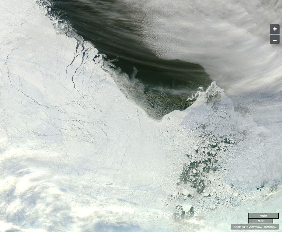
That area of the Arctic is currently obscured by cloud, but here’s an image captured by the Aqua satellite earlier today of the “broken ice sheet” off “Russia’s northern shores”:
The Arctic sea ice edge off “Russia’s northern shores” (Click for larger version)
Image courtesy of NASA Worldview from from the Aqua satellite.
Can you by any chance spot any cracks and/or holes in the supposedly “unbroken ice sheet”? Can you spot “Russia’s northern shores” for that matter?
In conclusion, for the moment at least, please note that we are now collecting all these periodical updates together in one handy location.
This website uses cookies to improve your experience. We'll assume you're ok with this, but you can opt-out if you wish. Cookie settingsACCEPT
Privacy & Cookies Policy
Privacy Overview
This website uses cookies to improve your experience while you navigate through the website. Out of these, the cookies that are categorized as necessary are stored on your browser as they are essential for the working of basic functionalities of the website. We also use third-party cookies that help us analyze and understand how you use this website. These cookies will be stored in your browser only with your consent. You also have the option to opt-out of these cookies. But opting out of some of these cookies may affect your browsing experience.
Necessary cookies are absolutely essential for the website to function properly. This category only includes cookies that ensures basic functionalities and security features of the website. These cookies do not store any personal information.
Any cookies that may not be particularly necessary for the website to function and is used specifically to collect user personal data via analytics, ads, other embedded contents are termed as non-necessary cookies. It is mandatory to procure user consent prior to running these cookies on your website.