We speculated a few days ago about whether the “Son of Storm Frank” might have battered Britain by now, and be sending a 10 meter swell past Svalbard towards the Arctic sea ice edge. That’s not quite how things have worked out in practice however! We haven’t had another named storm affecting the United Kingdom directly, but we have received a series of long distance swells from a sequence of hurricane force storms further out in the North Atlantic. I even managed to test my Arctic surfing equipment by personally partaking in the swell generated by Hurricane Alex!
Sorry to disappoint you @AvaPlaint. I'll update it eventually, but I'm just editing a #HurricaneAlex #Surfing video! pic.twitter.com/2sqaZD46FL
— Jim Hunt (@jim_hunt) January 18, 2016
Moving from the water into the air, here’s the Danish Meteorological Institute’s forecast for Greenland tomorrow:

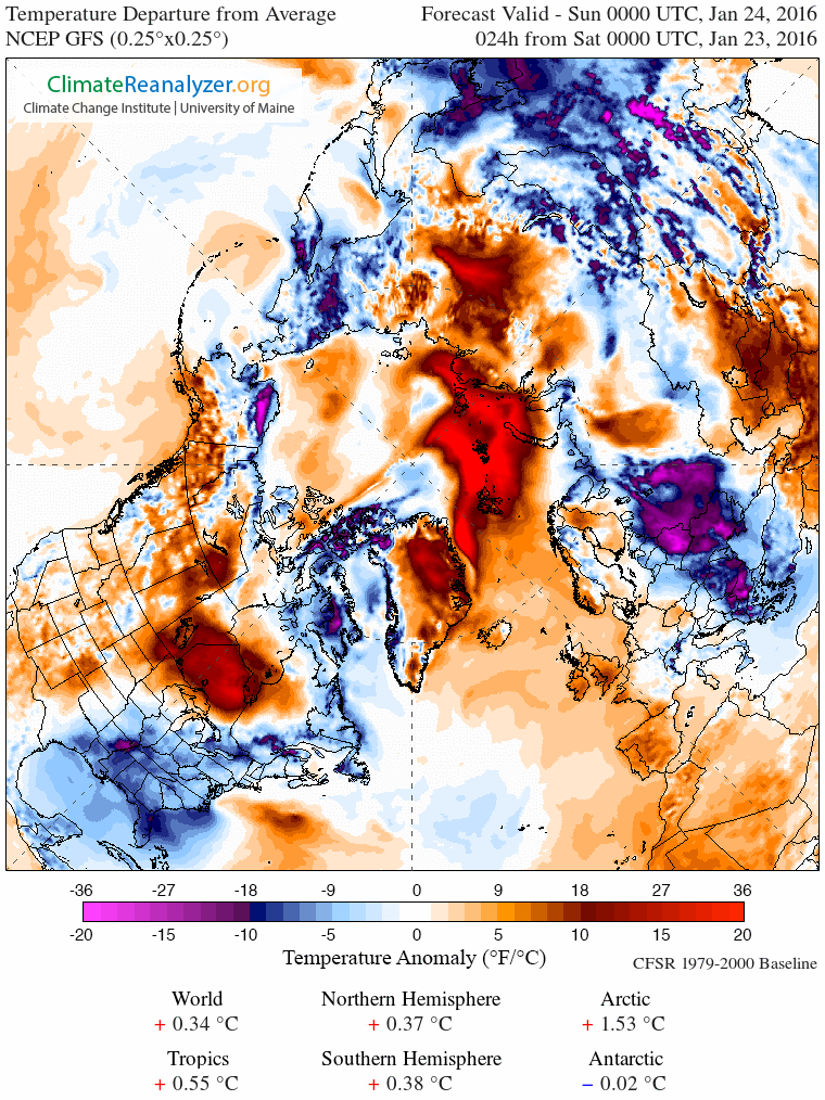
If you’re at all familiar with isobars you’ll note yet another storm off Southern Greenland and that comparatively warm, moist air will be heading up the east coast of Greenland towards the Fram Strait, albeit not at the speeds generated by Storm Frank! As a consequence here is Climate Reanalyzer’s surface temperature anomaly map for first thing tomorrow:
and here is how it looks by Wednesday lunchtime:

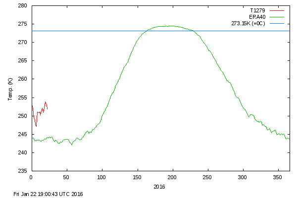
As you can see, the ultimate effect of the recent hurricane force storms in both the Atlantic and the Pacific is to attack the Arctic with warm, moist air from both sides. Whilst we wait to see exactly how this much shorter term forecast pans out, particularly at the North Pole itself, the DMI’s graph of temperatures in the central Arctic has burst back into life after a “brief hiatus” in the New Year. Here’s how it looks at the moment:
BLOWTORCH…lol
Heads are probably exploding over at troll central, if I wasn’t flushed down the #memory_hole it would be a great time to visits steve’s sewer of a blog.
Things are gradually warming up Lawrence, although not really a “blowtorch” just yet!
Here’s Svalbard yesterday:
and AMSR2 today:
Of course it is not a blowtorch, it is winter. The word was used to poke fun at the second dumbest man on the internet
http://bit.ly/1ZIyKHu
The UK Met Office have just released two videos which suggests they are contemplating naming the “Son of Storm Frank” in the not too distant future:
The accompanying weather warning for here in the United Kingdom tomorrow currently looks like this:
Here is the surf forecast for today:
It looks like the Greenland Sea is currently on the receiving end of an even bigger swell than once again Soggy South-West England!
Recent data from weather buoys near the North Pole is now available, and here’s how it looks. Firstly buoy 300234062788470 which is on the Pacific side of the North Pole:
and then buoy 300234062785480 from the Atlantic side:
Visually interpolating between the two then it appears to be just about feasible that “air temperature” at the North Pole itself briefly reached zero degrees Celsius (or Celcius as the graphs have it)? “Surface temperature”, however, did not. Here’s how DMI’s “daily mean temperature of the Arctic area north of the 80th northern parallel” looks this morning:
Rather than a sudden large spike in the last few days it reveals more of a “plateau” during January 2016, well above the normal temperature at this time of year.
Another named storm is due to batter the British Isles this evening and tomorrow. However she is Frank’s daughter rather than his son, and called Storm Gertrude. Here’s an explanatory video from the UK Met Office:
Here’s the Met Office’s forecast for lunchtime tomorrow:
Whether as a result of the recent “anomalous heat” and/or the “anomalous Greenland surf forecast” the JAXA/ADS Arctic sea ice extent metric is once again at the lowest ever level for the date, at least since their records began:
As per usual, Cryosphere Today Arctic sea ice area is reporting with a couple of days delay. On January 27th that metric also reached the lowest ever level for the date, since their records began:
12.14734 million square kilometres
An image of Storm Gertrude spinning North of the British Isles yesterday, courtesy of the MODIS instrument on the Terra satellite:
Meanwhile here is the Met Office’s synoptic chart for midnight on Sunday:
Yet more closely packed isobars following in Gertrude’s footsteps across the North Atlantic!
After two down days in a row the NSIDC daily Arctic sea ice extent has joined JAXA/ADS extent and CT area in the “lowest ever level for the date” category. The 5 day averaged version is still a smidgeon above 2006.
Meanwhile Storm Henry has started battering the British Isles with hurricane force winds:
Note also the “developing hurricane force” winds south of Greenland. Over in the North-East Pacific hurricane force winds are also heading for Alaska once again: