David Rose has now had another article published in the Mail on Sunday. The new one refers back to his previous words of wisdom about the Arctic, imparting this piece of information:
The Mail on Sunday’s report last week that Arctic ice has had a massive rebound this year from its 2012 record low was followed up around the world – and recorded 174,200 Facebook ‘shares’, by some distance a record for an article on the MailOnline website.
That’s a lot of people repeating a load of old nonsense! Here at GreatWhiteCon.info we also have a Facebook presence, so if you would like to share our alternative interpretation of what’s really going on in the Arctic please take a good look at:
https://www.facebook.com/GreatWhiteCon
and share that information with your friends, as long as it makes more sense to you than David Rose’s record breaking article. Meanwhile here in at Great Ivory Towers we’ve still only progressed as far as the third sentence in David’s article the weekend before last, which reads as follows:
Them:
Days before the annual autumn re-freeze is due to begin, an unbroken ice sheet more than half the size of Europe already stretches from the Canadian islands to Russia’s northern shores.
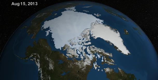
As you’ll discover below we’ve been experimenting with YouTube recently, where we stumbled upon a NASA video which led us to a page on NASA’s Goddard Space Flight Center web site where you can download a high resolution version of the same video. We did that, and then much like the Mail, we took a screenshot from the video to reveal an image remarkably like the one they published just over a week ago. Here it is:
Us:
We also found that NASA’s Scientific Visualization Center had another similar video available for download, covering the period from August 1st to September 13th 2012. Here’s a screenshot we took from that video, for August 15th 2012:
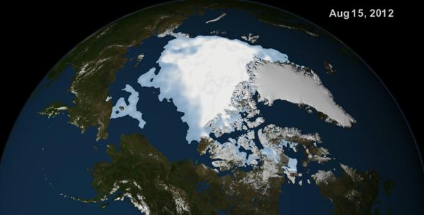
For some reason a similar image cannot however be found in David Rose’s Mail on Sunday article of September 8th 2013. Instead that contains an image labelled “August 27th 2012”. Whilst you ponder why the Mail was avoiding comparing like with like visually 9 days ago, here’s a little animation we’ve put together using alternative visualizations of Arctic sea ice, this time of ice concentration and generated by the University of Bremen. It shows how the sea ice cover has been changing from August 15th through to September 13th 2013, which may ultimately prove to be day of the minimum extent in 2013, using the NSIDC’s methodology at least. Note that it lingers for a while on August 27th, and we hope you like the sound track!
Verdict:
For reasons known only to themselves the Mail certainly weren’t comparing like with like visually on September 8th 2013. They evidently weren’t comparing like with like numerically either, since however hard we try comparing numbers from “the same time last year” we can’t come up with the Mail’s magic “60% increase”. Comparing NSIDC extent for August 15th 2013 with August 27th 2012 did however lead us to perform this bit of elementary arithmetic:
6.16 / 3.94 = 1.56 – A 56% increase.
However hard we try we still can’t get close to the Mail’s “nearly a million more square miles of ocean covered with ice than at the same time last year – an increase of 60 per cent”. We also challenge all and sundry to watch our video and then loudly proclaim, with a straight face, that “an unbroken ice sheet more than half the size of Europe already stretches from the Canadian islands to Russia’s northern shores”.
The NSIDC have now published their latest edition of Arctic Sea Ice News. They say that:
They go on to point out that:
They also link to another NASA video, this time running up to September 12th. September 8th looks like this:
Note the “break” in the ice in the form of the “Polar Polynya”, and the wide band of blue ocean between the ice edge and “Russia’s northern shores”. The accompanying text states that:
Thus the concentration data is used to determine the ice edge, but not the colours within the ice sheet. Our own animations display daily ice concentration only.