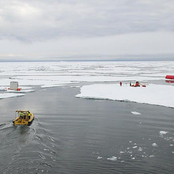
I just watched the live stream of the fall 2016 AGU press conference about the findings of the “First results from the Norwegian Young Sea ICE Expedition”.
Here’s the associated video of the expedition:
Here are the bullet points:
Initial results suggest that the thinner and younger ice is altogether different from older multiyear ice. It moves faster, breaks up easier, melts faster, and is more vulnerable to storms. This has important consequences for the Arctic as a whole, as our current knowledge is largely based on information from the “old Arctic.”
The Atmosphere
• For the first time, N-ICE2015 researchers directly observed large winter storms over sea ice and saw that they have significant effects on the young, thinner ice. The high winds create a lot of stress on the sea ice by pushing it around and breaking it up.
• One winter storm raised the air temperature from -40 F to +32 F in less than 48 hours, while the moisture in the air increased 10 times. All of these factors significantly warm the surface of the snow, even in mid-winter, and slow the growth of ice.The Sea Ice and Snow Cover
• Researchers on the drifting ice camps found more snow on top of the ice than expected. This insulated the ice from the atmosphere, slowing its growth in winter and surface melt in summer.
• The sea ice was sometimes flooded by seawater as the large snow load pushed the thinner ice below sea level.
• The thinner sea ice was more dynamic than researchers have seen before. This could mean more ridging but also more cracks and leads between ice floes.The Ocean
• Winter storms caused the sea ice to drift so fast that it increased mixing of the water beneath the ice. Deeper, warmer water was mixed up closer to the sea ice, causing it to melt from below despite winter air temperatures that were below freezing.
• Researchers saw summer storms stir up deep warm waters and melt as much as 25 cm of ice in a single day.The Ecosystem
• For the first time, N-ICE2015 researchers observed an algae bloom under snow-covered pack ice. Thinner and more dynamic Arctic sea ice allows more light transmission to the ocean, especially through cracks and leads. This triggers earlier phytoplankton blooms under the snow-covered ice.
• The phytoplankton species that dominated the under-ice bloom does not sink to the deep ocean. Such shifts in phytoplankton species composition, associated with early under-ice phytoplankton blooms, could thus have important implications for the strength of the biological carbon pump in the Arctic.
There was also mention of the “waves in ice” event that the R/V Lance experienced back in June 2015:
P.S. A recording of the N-ICE2015 press conference is now available:
Next up on the live stream is was the 2016 “Arctic Report Card“. Here’s the associated video:
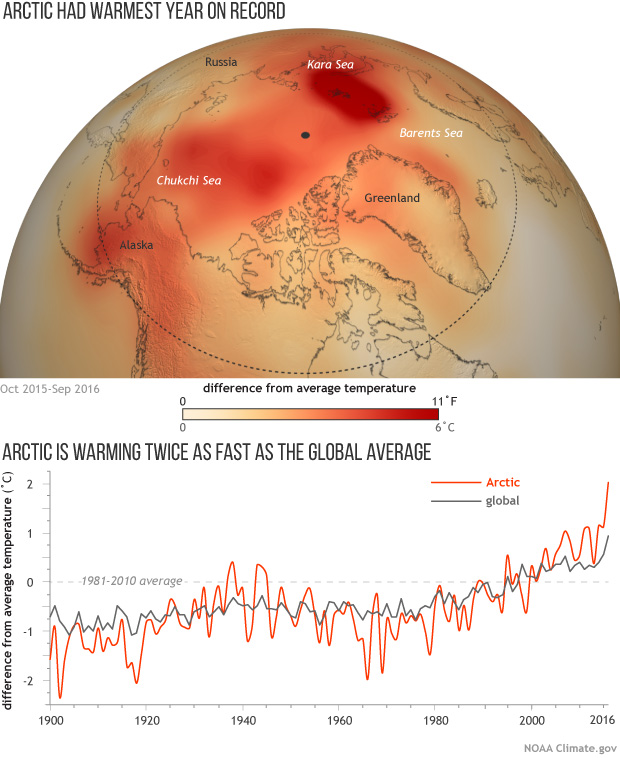
No doubt because of the recent controversy concerning the effects of the 2015/16 El Niño the first graphic that caught my eye was this one:
In the question and answer session the obvious question was asked. The answer was that while attribution is difficult the 2015/16 El Niño did have some effect on Arctic sea ice. However currently we’ve only seen “the first act of a 3 act play”. Act 2 will be the maximum extent in March.
In answer to another question, a focus of research over the next 10 years should be the interactions between mid latitudes and the Arctic.
P.S. A recording of the Arctic Report Card press conference is now available:
A variety of cryospheric posters are available via:
https://agu.confex.com/agu/fm16/meetingapp.cgi/Index/EPoster~1/Program/1175


The last graphic seems to show The Arctic as somewhat of a harbinger.
(I don’t think we’ve got 8 years!)
Well Jeremy Mathis did say at AGU that El Niño has had some effect on the Arctic. If David Rose is right both the red and grey lines will be falling like proverbial stones RSN!
Alternatively?
What does RSN mean?
Real Soon Now!
Yes, of course: testable hypothesis is good… I will have to keep an eye on this blog for good measure.
You also showed that the neutral phase seems to be the order of the day and not la nina as people have seemed to assume.
Those massive upticks seems to say the el nino can safely be assumed to be partly responsible but I would venture to say that a step change has kicked in and therefore stones dropping is possibly not exactly what we will see. It seems David Rose has his back up against a wall and knows it so is curbing his language ala Trump but the internet never forgets.
I was making simple observation of the graph- and may be I am falling for visual illusions, possibly, yes- but it seemed the red line was reacting to the grey line in such a sensitive fashion. If the grey line was going into stall mode then the orange line basically did more than that: it stagnated and died etc… exaggerating the situation if you will!!
… neatly reinforcing my own conclusions that the upticks at the end looked really bad.
(I was thinking out loud perhaps.)
They also talked about “Arctic amplification“, so maybe your “simple observation” isn’t too far off the mark?
I’m always being told that the ocean in the NH is only 1 km deep versus 4km deep in the SH. Asking if this is the reason why the SH is colder than the NH I am quickly reminded about the fact that there is also a massive ice block. Then there is land mass.
So there are multiple reasons why the NH and the SH are so different. Wayne, from the forum and his blog, says that the open ocean is a fairly direct correlation of the abnormal dmi 80N graphs… I don’t understand all those weather maps and stuff but suffice to say the conditions must be so different when it is a continent surrounded by ocean on the one hand and an ocean surrounded by continents on the other.
All I know is in the SH the wind patterns are tightening around Antarctica (Although I don’t know WHY this is, I’ve just been told THAT IT SIMPLY IS A FACT!!) giving the Australian continent less rain, or atleast in the south west of Western Australia that is. So, there are changes down here aswell but as it is all about heat engines I think the Arctic is simply putting on a spectacle via newly formed areas of open ocean.
Actually, I may have been told that that wind patterns reflect the ocean currents and the circumpolar current around Antarctica has been tightening (Once again, I don’t know why) and so the wind patterns are copying this behaviour.
[All this I’ve just been told without knowing how to really interact when being told such things.]
To be frank I’m not sure that anyone has a handle on all this stuff at the moment. As Mats Granskog put it:
Even the Great British Met Office is flummoxed by the events of 2015/16:
A pertinent image taken at the “Stand Up For Science” protest outside AGU yesterday:
A pertinent graph from the Arctische Pinguin?
There’s quite a few papers promised about the Lance expedition. The first ones seem to be (paywalled) at:
http://agupubs.onlinelibrary.wiley.com/hub/issue/10.1002/(ISSN)2169-9291.NICE1/
See also:
https://www.researchgate.net/project/Norwegian-young-sea-ICE-N-ICE2015-expedition
This slightly older article is freely available for example:
Arctic Research on Thin Ice: Consequences of Arctic Sea Ice Loss
To a complete novice looking through all the current data, it looks like we are entering a period of exponential temperature increase. That is extremely scary.
If you check out the Arctic Report Card press conference video above you will note that Jeremy Mathis of NOAA stated:
Hence it’s feasible that the apparent “exponential curve” will flatten a bit in the short term. Having said that, things are still scary. For example the professionals are starting to say things like this:
Hi Jim, taking another look. This is a very useful summary and I’m glad I revisited it.