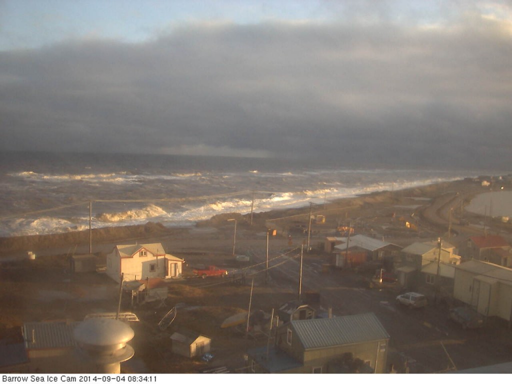
The first big waves of 2015 have been battering the town of Barrow, Alaska today and they’ve already broken through the coastal defences. Firstly take a look at the view from the Barrow webcam during a less damaging storm on September 4th last year:
Now take a look at the view from the same camera earlier today, and play “spot the difference” with me:
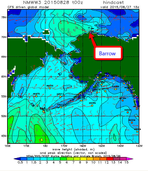
The cause of the flooding that is all too visible is a cyclone that’s been whirling around in the Chukchi Sea for a while, and here is a WaveWatch III “hindcast” of what the resultant winds have created in the way of waves. Firstly the “significant wave height”:
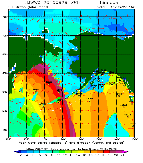
and now the “peak period”:
which reveal a swell 4 to 5 metres high with a period of 10 seconds heading directly towards Barrow Beach. According to the Alaska Dispatch News:
Huge, wind-whipped waves crashed onto the shore at Barrow on Thursday, forcing the closure of a nearby road. Westerly winds were gusting up to 50 miles an hour, pushing waves up to the top of the beach and causing some erosion, the National Weather Service said.
The service has issued a coastal flood warning for Barrow until Friday morning, along with a high surf advisory for the western part of the North Slope and a gale warning for much of the Beaufort and Chukchi Seas.
The big surf and flooding, which has covered a road that runs between the ocean and Barrow’s lagoon, is “not terribly unusual” at this time of the year, said Ryan Metzger, a National Weather Service meteorologist in Fairbanks. Fall is a stormy season, and the timing — right around the annual minimum sea ice extent — allows the surf to build and reach shore.
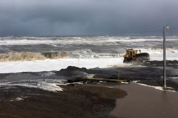
Just in case it’s not obvious from all the pictures, the respective advisory messages point out that:
A COASTAL FLOOD WARNING MEANS THAT RISING SEA WATER THAT CAUSES FLOODING IS EXPECTED. COASTAL RESIDENTS IN THE WARNED AREA SHOULD BE ALERT FOR RISING WATER…AND TAKE ACTIONS TO PROTECT LIFE AND PROPERTY.
A HIGH SURF ADVISORY MEANS THAT LOCALIZED BEACH EROSION IS EXPECTED. PRECAUTIONS SHOULD BE TAKEN TO PROTECT PROPERTY.
If you’re now wondering what might happen to other areas of the north coast of Alaska in similar circumstances, but with no bulldozer in attendance, here’s an example from Cape Halkett:
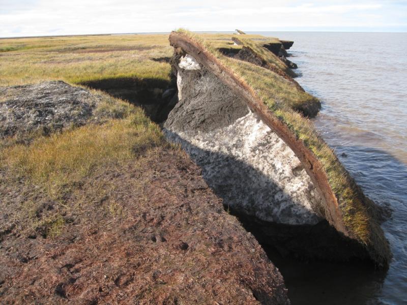
According to to the United States’ Climate Resilience Toolkit:
Thawing permafrost causes coastline collapse on Alaska’s North Slope, which is no longer kept frozen and protected from fall storms by sea ice—the ice now forms later in the season.
Away from the coast swell from the same cyclone has also been affecting the sea ice north of Barrow, and here’s what a webcam bobbing about on a buoy north of the Chukchi Sea showed as the winds started to build yesterday:
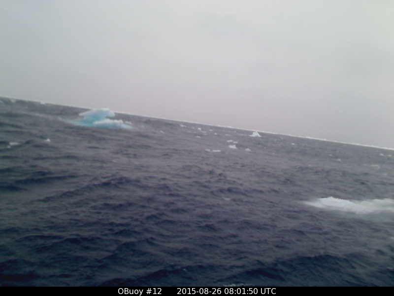
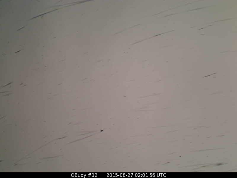
O-Buoy 12 has now tipped over and then ceased transmitting. This is the last picture received, in the early hours of August 27th when the wind speed had reached 13 m/s and the buoy had been moving at over 5 m/s:
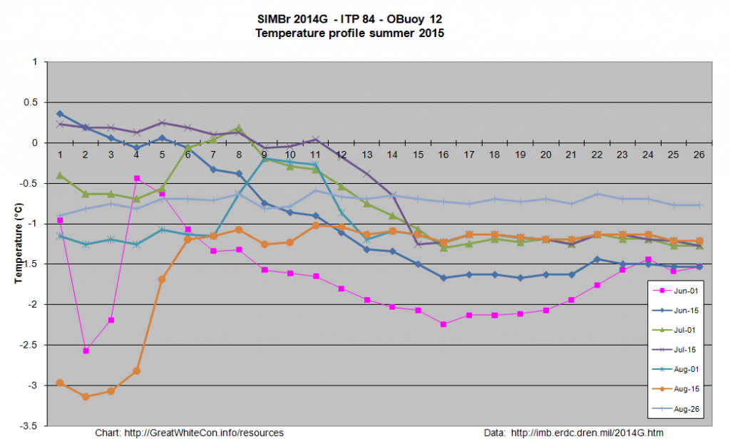
Once upon a time O-Buoy 12 was sat on the same ice floe as ice mass balance buoy 2014G, which has also been free floating for a while. Here’s what it reveals about the temperature of the sea water on August 26th 2015 at 77.56 N, 163.86 W:
Somewhere in the vicinity of -0.7 °C.
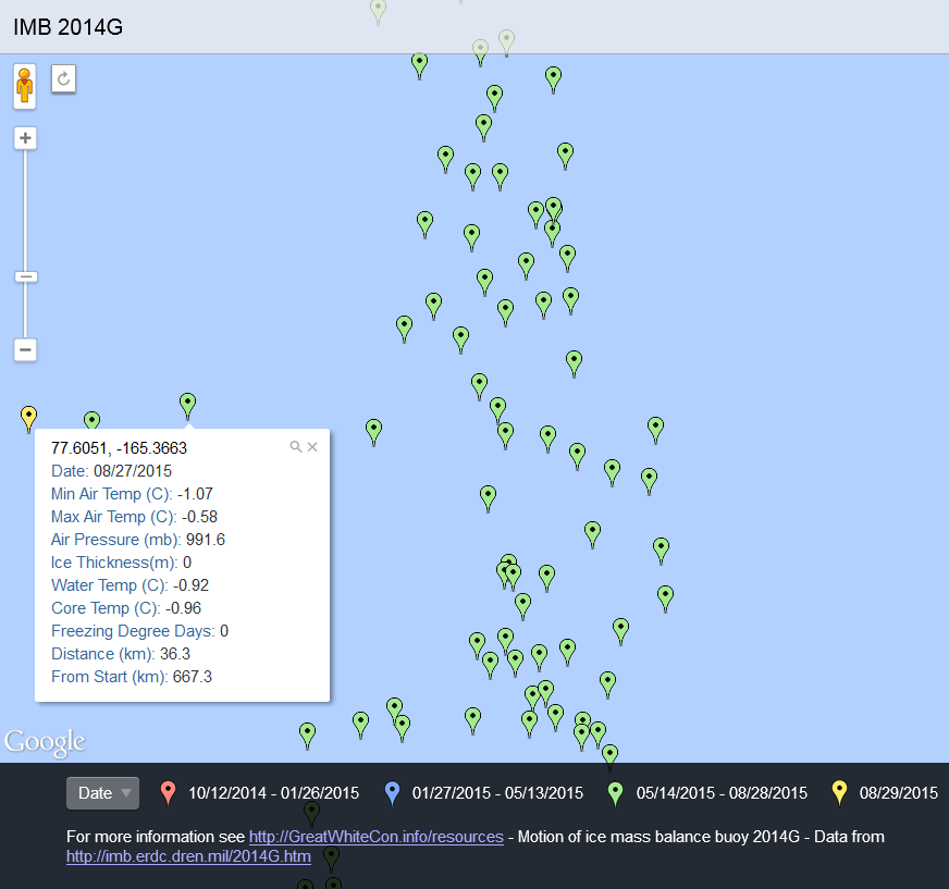
O-Buoy 12 has made no further transmissions, and therefore seems to have succumbed to the storm. In addition IMB buoys 2014F and 2013F stopped transmitting on the 26th and 27th of August respectively. Ice mass balance buoy 2014G has survived however, and reports two successive record daily distances travelled:
25.6 km on August 26th, followed by 36.3 km on the 27th. After a brief dip during the cyclone water temperature is still around -0.7 °C.
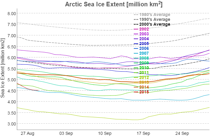
Presumably as a result of the cyclone JAXA Arctic sea ice extent has taken a tumble over the last few days. It has stabilised this morning slightly above 2007 levels:
Here is the current AMSR2 Arctic sea ice concentration map from the University of Hamburg, revealing a large potential fetch across the East Siberian, Chukchi and Beaufort Seas should any further cyclones occur in the area over the next few weeks:
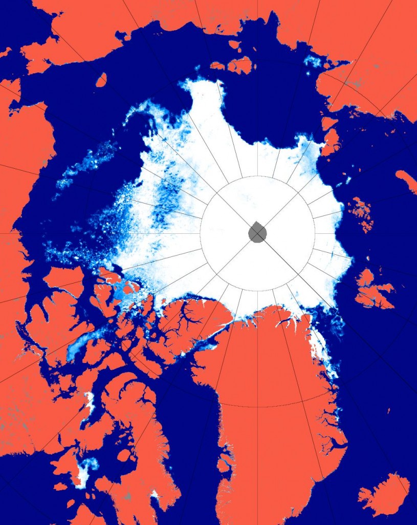
Hence the conditions now exist for an even more damaging swell to be generated before the 2015 minimum Arctic sea ice extent is reached.

Since a cyclone is semicircular in nature would you not have the same kind of waves going in the opposite direction either smashing the edges apart or to my mind even worse slipping under the ice and smashing to pieces the thinner ice farther in the middle and adding greater weakness to the polar ice and in the next week we could be seeing another storm coming from the other side.
What I mean by semicircular is that it is not a perfect circle shape.
I’m not sure I’m following you yet Bryan. Cyclones are not perfectly symmetrical, and in the Arctic where they’re spinning partly over sea ice and partly over open water the resulting swells are extremely “asymmetrical”.
If at one point in time a big swell is heading in the direction of Barrow it won’t simultaneously be heading straight for the MIZ. Is that what you mean? If so see for example this period chart from August 26th:
lot of suspended silt in the water from that storm jim, increases the capability of the sun to warm the water ,if the sun makes it through the clouds.
Actually the clouds are clearing. See:
https://greatWhiteCon.info/resources/arctic-sea-ice-images/summer-2015-images/#CAB
This is the “Beaufort Bite” north of 80 degrees:
on that scale i would think every bit of visible ice would be more than 2 m thick jim. looks like 3rd or 4th lowest extent depending on whose output you look at . been more compaction than melt last few days going by temperatures.
Thanks Jim, lots of helpful detail and the kind of visual information that helps me understand best. That extent dip is unexpected, watching daily at this point, of course. I do often come over when you provide links to your superb work.
I’ll be watching to see if any of those Pacific cyclones heads north, as JDallen pointed out. I had a question myself about what might be in the way. Here’s the ongoing link of GOES West for reference:
http://www.ssec.wisc.edu/data/geo/index.php?satellite=west&channel=wv&coverage=fd&file=gif&imgoranim=8&anim_method=flash
and one more, from the North Pole perspective, this one preferable as one can slow it down:
http://mp1.met.psu.edu/~fxg1/SAT_NHEM/animwjap.html
To my amateur eye, the question would be, is that mess between the storms and the Arctic more likely to be a funnel or a block. [Yes, I know, amateur is a bit of an understatement when I write things like that ;)]
Every run of GFS looks very different so far out, and hence I have very little confidence in this 12:00 version, but….